List of ghost towns in Nevada

Last updated

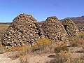
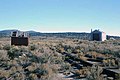
Most ghost towns in Nevada in the United States are former mining boomtowns that were abandoned when the mines closed. Those that were not set up as mining camps were usually established as locations for mills, or supply points for nearby mining operations.

Contents

In Clark County, settlements along the Colorado River have been submerged underneath the reservoirs of Lake Mead or Lake Mohave.

Conditions

Ghost towns can include sites in various states of disrepair and abandonment. Some sites no longer have any trace of buildings or civilization, and have reverted to empty land. Other sites are unpopulated but still have standing buildings. Still others may support full-time residents, though usually far fewer than at their historical peak, while others may now be museums or historical sites.

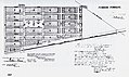
For ease of reference, the sites listed have been placed into one of the following general categories.

Barren site
Neglected site
Abandoned site
Semi-abandoned site
Historic site

List of ghost towns in Nevada

Nevada ghost towns
TownOther namesImageCountyEstablishedDisestablishedStatusNotes
Alturas Clark 1861In El Dorado Canyon near Techatticup Mine in the Colorado Mining District.
Aurora Aurora NV.jpg Mineral 1860Neglected site
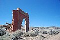
According to published time-lines, Aurora's population suffered greatly in 1865. Only two mills were still in operation. In 1866 much of the town was leveled in a Great fire That burned most of the business district. A second fire followed in 1873, and by 1880 the population had dropped down to less than 500 persons.
Austin Austin, Nevada (King Survey), 1868.jpg Lander 1862Historic siteClifton was still active in 1865 but when the mill closed in 1867, the town was abandoned. While Austin's mining activity was at its peak during the late 1860s ...
Beatty Nye 1905Historic siteAround Indian Springs, Nevada. Beatty is known for two things, as a gateway to Death Valley and the ever-popular road trip stop, the Death Valley Nut and Candy Company.
Belleville Mineral 1872 (1915)1892 (1918)By the late 1880s pipes delivered water to Candelaria and allowed local mills to begin operation, reducing the need for shipping costs. Belleville could not survive the competition and was deserted by 1892.
Belmont
Belmont, NV Courthouse.jpg
Nye 18651922Semi-abandoned siteFormer Nye County courthouse in Belmont is preserved as Belmont Courthouse State Historic Park. [1]
Berlin Berlin Ghost Town.jpg Nye 18971911Historic sitePreserved within Berlin–Ichthyosaur State Park [2]
Bermond Station Frenchman Fairview & Bermond Station Nevada 1910.jpg Churchill 19201926The site was also known as Frenchman or "Frenchy's and later as Bermond Station from 1920 to 1926. [3]
Blair Blair Nevada Stamp mill c 1907.jpg Esmeralda 19061916Neglected siteThe site of the largest stamp mill in Nevada (100 stamps), at the time [3]
Bristol Wells Charcoal Kiln, Bristol Wells.jpg Lincoln 18721905Abandoned siteBy 1893, however, Bristol Well fell out of use. In 1900, a copper leaching plant was built to treat ore from the Bristol Mine, but it only operated for two years. After the railroad was completed through Lincoln County in 1905, Bristol Well wasn't used again.
Broken Hills Broken Hills, Nevada b 1920.jpg Mineral 19131940Neglected site
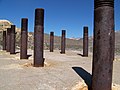
Broken Hills is a ghost town in Mineral County, Nevada. It was primarily the site of the mining operation of miners, Joseph Arthur and James Stratford from ...
Bullfrog Inside Bullfrog Jail.jpg Nye 19041907Neglected siteFounded just south of Rhyolite, had a rivalry with Rhyolite. Rhyolite eventually won out before becoming a ghost town as well.
Bullionville Bullionville loading tailings b 1880.jpg Lincoln 18701882Barren siteA reliable water supply supported milling in town until nearby Pioche built waterworks to supply water to Pioche mills. Afterward, Bullioniville was slowly abandoned. [3]
Cactus Springs Nye 19101935Cactus Springs is a ghost town in Nye County, Nevada. It is currently within the boundaries of the Nellis Air Force Range.
Callville Lake Mead Callville Bay Marina 2.jpg Clark 18641869Submerged under Callville Bay of Lake Mead Steamboat landing, County seat of Pah-Ute County, Arizona Territory (1865–67), post office (1867-69)
Candelaria Main street Candelaria Nev c 1880.jpg Mineral 18641939Neglected siteThe Northern Belle mine produced 15 million dollars in silver during production. [4]
Chafey Dun Glen Chafee Nevada 1908.jpg Pershing 19081913Was originally called Dun Glen. [3]
Charleston 2013-06-28 10 00 10 View east along Elko County Route 746 (North Fork-Charleston Road) in Charleston in Nevada.jpg Elko 18761956Abandoned site
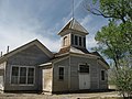
Charleston is a ghost town in Elko County, Nevada, United States. ... It lies along the Bruneau River just south of the Mountain City and Jarbidge Ranger ...
Clifton Lander 1862Semi-abandoned siteJust west of Austin.
Coaldale Coaldale Junction.jpg Esmeralda 18941993Neglected siteLeaking fuel tanks forced closure of the gas station around 1993, and with no other reason to stop, the place folded. Sometime in the mid 2000's the restaurant mysteriously caught fire. Over the years, a number of people were involved in what would be known in later years as Coaldale.
Cobre Cobre Nevada.jpg Elko By 1937, only about 20 people lived in Cobre, and in November 1948 the Southern Pacific abandoned the station. Ore shipments continued through Cobre until June 20, 1983, when the smelter at McGill closed. Today, not much remains of Cobre and a large cinderblock engine house from the 1960s dominates the site.
Colorado City Clark 1861Submerged under Lake Mohave Steamboat landing near the mouth of El Dorado Canyon in the Colorado Mining District.
Columbus Borax refining tanks, Columbus Nevada 1870s.jpg Esmerelda 18651881Neglected site
Como Horse-powered whim Como Nevada.jpg Lyon 18611930sPost office 1879–1881, 1903–1905; mining town occupied intermittently, activity finally ceasing in the 1930s after the closing of a sawmill. [3]
Cortez Cortez Mill Complex Tier C.jpg Lander 18631930 George Hearst mined at the area in the 1860s.
Crystal Springs Crystal Spring - Nevada.jpg Lincoln
Currant 2014-07-17 09 55 40 Panorama of Currant, Nevada from U.S. Route 6 about 118 miles east of the Esmeralda County Line-cropped.jpg Nye 18651871
Daveytown Humboldt 19101930
Deeth 2015-03-31 18 52 31 Buildings along Deeth-O'Neil Road (Elko County Route 753) in Deeth, Nevada.JPG Elko 18691915A depot and trading center for local ranchers and ranchers from adjacent counties.
Delamar Delamar Nevada newspaper office.jpg Lincoln 18901909In 1897, Delamar had a population of 3000. [3]
Delano Elko 18721927The town was the site of a small gold-mining district that saw production from the 1870s to the 1960s.
Dixie Valley Dixie Nevada 1910.jpg Churchill 1861
Dun Glen Dun Glen Nevada 1880.jpg Pershing 18621894Later became Chafey. [3]
Eagleville Mineral 18851915Neglected site
El Dorado City Clark 18631880sBarren siteMining camp in El Dorado Canyon in the Colorado Mining District. Site of the El Dorado Mills.
Etna Pershing 18651872
Fairview Fairview Nevada July 4th 1906.jpg Churchill 19051919At its height, Fairview had 27 saloons. [3]
Fish Lake Valley Esmeralda
Flanigan Flanigan townsite map.jpg Washoe 19091973
Fort Churchill Fort Churchill Gelatin.jpg Lyon Preserved within Fort Churchill State Historic Park [5]
Frenchman Frenchman Station Nevada 1910.jpg Churchill 19061920The site was also known as Frenchy's and later as Bermond Station 1920–26 [3]
Genoa Mormon Station Douglas 1851Historic siteOriginally called Mormon Station. Now part of Mormon Station State Historic Park
Golconda Golconda School - Golconda Nevada.jpg Humboldt 18691908Golconda's hot springs were a famous landmark for westbound travelers. [3]
Gold Center Mill foundation, Gold Center, Nevada.jpg Nye 19041919Barren siteThe origin of Gold Center’s name is a mystery, for it was not the center of anything and it had no gold. It was a critical water source for nearby Bullfrog and Rhyolite and at one time had a large brewery and the only distilled water ice plant in Nevada.
Gold Point Gold point street.jpg Esmeralda
Goldfield Esmeralda County, Nevada courthouse.jpg Esmeralda 1902Historic site
Goodsprings Clark 1900
Grantsville Nye
Hamilton Cave City Hamilton Nevada.jpg White Pine 18681931Hamilton was originally called Cave City, because early arrivals set up camp in nearby caves. [3]
Hardin City Humboldt 18581866Neglected
Hiko MILL OF HYKO SILVER MINING COMPANY, HYKO, NEVADA - NARA - 524161.jpg Lincoln 18651882Hiko was a Native American expression meaning "white man's town". [3]
Ione Ione nevada 1900.jpg Nye 18631930sAt its peak, Ione had 100 houses and a population of 500. [3]
Jacobsville Lander 1859Late 1870sA Pony Express station and the first seat of Lander County.
Jarbidge Elko 1909
Jessup Jessup, Nevada 1910.jpg Churchill 1908
Johnnie Nye 18901935Barren siteWater in town was scarce. It was drawn from a spring four miles away, packed in canvas bags, and hauled to town by donkeys. [3]
Johntown Placer mining 1880s at site of Johntown , Nevada mining settlement.jpg Lyon 18531860sBarren siteConsidered to be the first ghost town of Nevada. [6]
Jungo Mapping the North Half of Lovelock One Degree Quadrangle in the Desert Area Near Jungo, Nevada, 1 August 1931.tiff Humboldt 19111952BarrenPost office from January 1911 until May 1952 [7]
Lahontan City Churchill 19111915NeglectedDeveloped to house workers during the construction of Lahontan Dam [8]
Lander Lander 18801921
Logan WATER RHYOLITES NEAR LOGAN SPRINGS, NEVADA - NARA - 524153.jpg Lincoln 18651930
Louisville Clark 18611862In El Dorado Canyon near the Techatticup Mine in the Colorado Mining District.
Lucky Jim Camp Clark 1862Barren siteIn El Dorado Canyon near the Techatticup Mine in the Colorado Mining District.
Marietta Mineral 18671894Neglected site
Mazuma Mazuma Nevada 1908.jpg Pershing 19071912Post office: 1907–1912. Site of flash flood that killed at least eight and destroyed most of the town. [3]
Metropolis A494, Metropolis, Nevada, USA, Lincoln School, 2016.jpg Elko 1909
Midas Gold Circle Gold Circle, Midas Nevada 1907.jpg Elko 19081942The camp was first called Gold Circle, but when the post office was established in 1907, officials decided that Nevada had too many towns with "gold" in their names, and the town was renamed Midas. [3]
Millers Esmeralda
Miriam White Plains, Ocala, and Miriam Nevada in 1910.jpg Churchill Non-agency station of the SPRR [9]
Mountain City 2013-06-16 15 39 22 View south across Mountain City in Nevada, with Nevada State Route 225 visible passing through town and the Owyhee River visible toward the right.jpg Elko 1870Semi-abandoned site
Nevada City Churchill 19161919A co-operative colony
Ocala White Plains, Ocala, and Miriam Nevada in 1910.jpg Churchill
Osceola White Pine
Palisade A339, abandoned car, Palisade, Nevada, USA, 2011.JPG Eureka 18681910
Palmetto Palmetto, Nevada ghost town.jpg Esmeralda 18661920sNeglected siteMiners named the town after local Joshua trees, which they thought were related to the palmetto tree.
Parran Parran Nevada 1910.jpg Churchill 1910A telegraph station and post office. Post office closed 1913. [10]
Pine Grove Pine grove nev steam boiler 1880.jpg Lyon 18661918Abandoned siteSeveral buildings remain. [4]
Pioneer Pioneer (ghost town) ruins.jpg Nye 19081931Barren sitePost office 19091931
Poeville Washoe 18641880Post office 18741878
Potosi Clark Barren site
Quartz Mountain Nye 19051922Barren siteLocated inside the Nellis Air Force Base Bombing and Gunnery Range.
Ragtown Churchill 1854Leeteville may be the same location.
Rawhide Rawhide Nevada 1908 a.jpg Mineral 1907Barren siteRawhide Mining Co. has destroyed any remains of the town. Now it is just an open pit mine.

Devastating fire in 1908, $1 million in property damage and thousands left homeless. [3]

Rhyolite A363, Rhyolite, Nevada, USA, John S Cook and Company building, 2004.jpg Nye 1905 [11] 1916Abandoned sitePost office closed 1913
Rio Tinto Elko 19321948A few houses and the school remain.
Rioville Junction City Clark 18691906Site is now under Lake Mead.Originally Junction City, Rioville had a post office from 1881 to 1906.
Rochester Rochester nv 1913 tent move.jpg Pershing 19121942
Ruby Hill Ruby Hill, Nevada 03.JPG Eureka 18731910
Ruth Ruth Neva, steam shovel 1910.jpg White Pine
Saint Joseph Clark 18651868BarrenSite located west of the north end of Overton Airport and east of the Muddy River. It burned down in 1868. Town name and population moved to what is now Logandale.
St. Thomas St. Thomas, NV Building Foundation.JPG Clark Submerged beneath Lake Mead. Ruins became visible when the waters of the lake were lowered.
Salt Wells Churchill 2007Site of a borax plant, bar, gas station and former brothel
San Juan Clark 1862The camp was abandoned just weeks after being established. [3]
Scossa Pershing 19311937One of the last important mining camps in Nevada. [3]
Seven Troughs Seven Troughs Nevada 1907.jpg Pershing 19071918
Silver Canyon Lincoln
Simonsville Clark 18651870sBarrenOriginally called Mill Point, located west of the south end of Overton Airport and east of the Muddy River.
Spruce Mountain 2013-06-27 10 07 04 Abandoned buildings adjacent to the old Monarch Mine on Spruce Mountain in Nevada.jpg Elko
Star City Pershing
Stillwater Stillwater, Nevada 1910.jpg Churchill 1862
Sulphur Humboldt Neglected
Tempiute Lincoln 18681957In the 1950s, the Lincoln mine was one of the primary producers of tungsten in the U.S. [3]
Tenabo Shoshone Range in Nevada.jpg Lander 19071930s
Treasure City White Pine 1869
Tybo Nye
Unionville Unionville, Nevada.jpg Pershing
Ute Clark Railroad siding and site of a silica mill in the 1940s.
Vernon Pershing 1905
Vya Washoe
Washoe City Washoe 18601910sNeglected site
White Cloud City Dixie Nevada 1910.jpg Churchill Also known as Coppereid
White Plains White Plains, Ocala, and Miriam Nevada in 1910.jpg Churchill 18791909"No vegetation meets the eye when gazing on the vast expanse of dirty white alkali." [12]
Wonder Wonder Nevada 1907.jpg Churchill 1906Post office closed 1920

Related Research Articles

<span class="mw-page-title-main">Bodie, California</span> Ghost town in Mono County

Bodie is a ghost town in the Bodie Hills east of the Sierra Nevada mountain range in Mono County, California, United States. It is about 75 miles (121 km) southeast of Lake Tahoe, and 12 mi (19 km) east-southeast of Bridgeport, at an elevation of 8,379 feet (2554 m). Bodie became a boom town in 1876 after the discovery of a profitable vein of gold; by 1879 it had established 2,000 structures with a population of roughly 8,000 people.

<span class="mw-page-title-main">Gerlach, Nevada</span> Census-designated place in Nevada, United States

Gerlach, Nevada is a census-designated place (CDP) in Washoe County, Nevada, United States. The population was 130 at the 2020 census. It is part of the Reno–Sparks Metropolitan Statistical Area. Prior to 2010, Gerlach was part of the Gerlach–Empire census-designated place. The town of Empire is now a separate CDP. The next nearest town, Nixon, is 60 miles (100 km) to the south on a reservation owned by the Pyramid Lake Paiute Tribe. The Fly Geyser is located near Gerlach.

<span class="mw-page-title-main">Pah Rah Range</span> Mountain range in Nevada

The Pah Rah Range is a mountain range located in western Nevada in Washoe County just to the northeast of Reno. It is a hook shaped range with the main eastern portion oriented northwest–southeast, approximately 20 miles (32 km) long. The northwest flowing Cottonwood Creek in Warm Springs Valley is bounded on three sides by the range. To the south and east the Truckee River forms the boundary and Pyramid Lake is at the northeast. Spanish Springs Valley north of Reno forms the southwest margin. To the north, the narrow Mullen Pass separates the Pah Rah Range from the Virginia Mountains.

<span class="mw-page-title-main">Rhyolite, Nevada</span> Ghost town in Nevada, United States

Rhyolite is a ghost town in Nye County, in the U.S. state of Nevada. It is in the Bullfrog Hills, about 120 miles (190 km) northwest of Las Vegas, near the eastern boundary of Death Valley National Park.

Ragtown, Nevada, is a Churchill County ghost town of an abandoned 1854 trading post west of Fallon.

<span class="mw-page-title-main">Belmont, Nevada</span> United States historic place

Belmont is a ghost town in Nye County, Nevada, United States along former State Route 82. The town is a historic district listed in the National Register of Historic Places. It is Nevada Historical Marker number 138.

<span class="mw-page-title-main">Aurora, Nevada</span> United States historic place

Aurora is a ghost town in Mineral County in the west central part of the US state of Nevada, approximately 22 mi (35 km) southwest of the town of Hawthorne, three miles from the California border.

Vya is a small ghost town located in Washoe County, in northwestern Nevada, United States. It is about 10 miles (16 km) east of the California state line, north of Forty Nine Canyon. Not much remains of the small town, which essentially died in the 1920s. Just two wooden buildings can still be seen—the Vya Post Office and Library. The Vya Post Office was in operation from September 1910 until October 1941. The settlement was named for Vya Wimer, the first European heritage baby born in the valley.

<span class="mw-page-title-main">Fort Churchill State Historic Park</span> Park in Nevada

Fort Churchill State Historic Park is a state park of Nevada, United States, preserving the remains of a United States Army fort and a waystation on the Pony Express and Central Overland Routes dating back to the 1860s. The site is one end of the historic Fort Churchill and Sand Springs Toll Road. The park is in Lyon County south of the town of Silver Springs, on U.S. Route 95 Alternate, eight miles (13 km) south of U.S. Route 50. Fort Churchill was designated a National Historic Landmark in 1961. A 1994 park addition forms a corridor along the Carson River.

<span class="mw-page-title-main">Coppereid</span> Ghost town in Nevada, United States

Coppereid, also known as White Cloud City is a ghost town in Churchill County, Nevada. It had a total population of 40 people. The site of Coppereid is south of Lovelock, east of the Carson Sink in the Stillwater Range.

Currant is an unincorporated community in Nye County, Nevada. Settled in 1868, it was first a farming town with a small population. Its current population is 65.

<span class="mw-page-title-main">Ione, Nevada</span> Ghost town in Nevada, United States

Ione, Nevada, is a ghost town in Nye County, Nevada, located approximately 23 miles (37 km) east of Gabbs, Nevada.

Potts is a ghost town and abandoned ranching property in Monitor Valley, Nye County, Nevada, approximately 2 miles east of Nevada State Route 82.

Tungstonia, Nevada, is a ghost town on the Southern flank of the Kern Mountains of Eastern White Pine County, Nevada, along Tungstonia Wash.

Schellbourne, formerly known as Fort Schellbourne and Schell Creek Station is a ghost town located in the Schell Creek Range in White Pine County in Nevada, United States, located 43 miles (69 km) north of Ely. The town was a stopover along the Central Overland Route, Pony Express and original routing of the Lincoln Highway. It is today Nevada Historical Marker number 51. The site was listed on the National Register of Historic Places in 1972. Its boundaries were increased in 1977.

<span class="mw-page-title-main">Fairview, Nevada</span> Historic site

Fairview is a ghost town in Churchill County, Nevada, in the United States of America.

Deep Wells is a ghost town in Eureka County, Nevada in the United States.

National is an extinct town in Humboldt County, in the United States state of Nevada.

<span class="mw-page-title-main">Parran, Nevada</span> Ghost town in Nevada, United States

Parran was a telegraph station and post office in Churchill County, Nevada, United States. It was established in 1910 and closed in 1913. The abandoned site is currently considered a ghost town.

References

  1. Belmont Courthouse State Historic Park Archived 2012-02-15 at the Wayback Machine
  2. "Berlin-Ichthyosaur State Historic Park | State Parks". parks.nv.gov. Retrieved April 1, 2022.
  3. 1 2 3 4 5 6 7 8 9 10 11 12 13 14 15 16 17 18 19 20 Paher, Stanley W (1970). Nevada Ghost Towns and Mining Camps. Howell North.
  4. 1 2 "Candelaria". Western mining history. Retrieved September 18, 2018.
  5. "Fort Churchill State Historic Park | State Parks". parks.nv.gov. Retrieved April 1, 2022.
  6. "Johntown, the first ghost town in Nevada". Sparks Tribune. July 29, 2017. Retrieved September 16, 2018.
  7. "Jungo Post Office (historical)". Geographic Names Information System . United States Geological Survey, United States Department of the Interior. September 1, 1991. Retrieved January 3, 2016.
  8. Lahontan City
  9. Carlson, Helen S. (1985). Nevada place names : a geographical dictionary. Reno: University of Nevada Press. p. 169. ISBN   087417094X.
  10. Carlson, Helen S. (1985). Nevada place names : a geographical dictionary. Reno: University of Nevada Press. p. 187. ISBN   087417094X.
  11. "The Most Haunted Ghost Towns". United States Ghost Towns. November 21, 2022. Retrieved May 23, 2023.
  12. Carlson, Helen S. (1985). Nevada place names : a geographical dictionary. Reno: University of Nevada Press. p. 245. ISBN   087417094X.