Ruth, Nevada

Last updated
Ruth, Nevada
CDP
Company Houses.JPG
Street Scene in Ruth, Nevada
USA Nevada location map.svg
Red pog.svg
Ruth
Location within the state of Nevada
Coordinates: 39°16′42″N114°59′18″W / 39.27833°N 114.98833°W / 39.27833; -114.98833
Country United States
State Nevada
County White Pine
Area
[1]
  Total0.35 sq mi (0.90 km2)
  Land0.35 sq mi (0.90 km2)
  Water0.00 sq mi (0.00 km2)
Elevation
6,880 ft (2,100 m)
Population
 (2020)
  Total371
  Density1,072.25/sq mi (414.24/km2)
Time zone UTC-8 (Pacific (PST))
  Summer (DST) UTC-7 (PDT)
ZIP codes
89319
FIPS code 32-63800
GNIS feature ID0845643

Ruth is a census-designated place (CDP) in White Pine County, Nevada, United States. Founded in 1903, it had a population of 440 at the 2010 census. [2]

Contents

Ruth was built as a company town for the adjacent Robinson Mine, a large open-pit copper mine, which is still in operation as of 2022.

Demographics

Historical population
CensusPop.Note
2020 371
U.S. Decennial Census [3]

History

Ruth began as a settlement for workers of the White Pine Copper Company in 1903. It derived its name from the Ruth mining claim which was named for Ruth McDonald, daughter of the original owner of the mining claim. [4]

With the opening Nevada Northern Railway in the year 1906 copper production began to boom.

Three-ton steam shovel, Ruth, 1910 Ruth Neva, steam shovel 1910.jpg
Three-ton steam shovel, Ruth, 1910

In 1905, Daniel C. Jackling "evaluated a low-grade copper prospect", which he turned into "an impressive open-pit and satellite cave (the Veteran Mine)." Jackling went on to become president of the Nevada Consolidated Copper Company. [5]

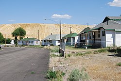
By 1910 the settlement was already established a small distance from the first site. Ruth was a company town for the Nevada Consolidated Copper Company: the houses belonged to the mine and the city and were administered by them. Saloons and bordellos were not permitted in the company town but were plentiful in the neighboring community of Riepetown.

A mine explosion in Ruth on July 12, 1912, killed ten people. In 1929 there was another explosion set off by dynamite blasts. 2 men were killed with a third injured. One of the killed men was Giovanni Simonetta from Cortale, Italy. [6]

In 1919 Ruth was the site of a labor dispute when 150 copper miners walked out demanding higher wages. Although some claimed the strike was instigated by the Industrial Workers of the World the leaders were actually from the Western Federation of Miners. [7]

At the beginning of the Great Depression, Ruth had almost 2,300 inhabitants. [8]

Nevada Consolidated Copper Co. was taken over by Kennecott Copper Corporation in 1933. [6]

Ruth ceased being a company town in 1955 when the houses were sold to the John W. Galbreath Company. Occupants were given the opportunity to purchase the homes they had been renting. Around this time the community was moved two miles north to make way for expansion of the Deep Ruth mine. [6]

In 1978 Kennecott closed the mines in Ruth, [9] which went into decline. The elementary school closed in 1986.

BHP reopened the mine in 1996. From 1996 to 1999, the BHP Nevada Railroad was based here. The mine closed again in 1999.

Quadra FNX Mining reopened the Robinson Mine in 2004, and it is still in full production as of 2022.

The Nevada Northern Railway Museum maintains some track in the area.

Ruth was featured in the fourth season of the Netflix original series Stranger Things as the location of the NINA project, which is housed in a converted missile silo. [10]

Ruth is the inspiration for the Stephen King novel Desperation . [11]

A panorama of Ruth, circa 1912 Ruth, Nevada panorama.jpg
A panorama of Ruth, circa 1912
A panorama of Ruth in 2014 2014-08-11 15 04 20 Panorama of Ruth, Nevada cropped.jpg
A panorama of Ruth in 2014

Notable people

Geologic structure map showing local mining operations with Ruth in the top center and Rib Hill in the bottom center. Ruth Pit is to the right and the Veteran Pit is to the left. The hatched area indicates traces of copper while the shaded area indicates traces of gold. Ely Mine Locations.PNG
Geologic structure map showing local mining operations with Ruth in the top center and Rib Hill in the bottom center. Ruth Pit is to the right and the Veteran Pit is to the left. The hatched area indicates traces of copper while the shaded area indicates traces of gold.

Climate

Ruth experiences a semi-arid climate (Bsk) with hot summers and cold winters, typical of most small towns in the Great Basin. Due to Ruth's substantial elevation and aridity, the diurnal temperature variation is large. Nights are cool, even in the summer, and frosts can occur any time of the year, although rare in summer months. Daytime highs in the winter tend to be a few degrees above freezing, but nights can be bitterly cold.

Climate data for Ruth, Nevada, 1991–2020 normals, 1958-2020 extremes: 6858ft (2090m)
MonthJanFebMarAprMayJunJulAugSepOctNovDecYear
Record high °F (°C)62
(17)
68
(20)
75
(24)
80
(27)
88
(31)
94
(34)
100
(38)
96
(36)
95
(35)
86
(30)
80
(27)
64
(18)
100
(38)
Mean maximum °F (°C)53
(12)
54
(12)
62
(17)
70
(21)
79
(26)
87
(31)
92
(33)
89
(32)
85
(29)
76
(24)
65
(18)
53
(12)
92
(33)
Average high °F (°C)37.7
(3.2)
40.2
(4.6)
47.1
(8.4)
54.0
(12.2)
64.3
(17.9)
75.7
(24.3)
83.9
(28.8)
82.3
(27.9)
74.6
(23.7)
61.4
(16.3)
47.0
(8.3)
37.4
(3.0)
58.8
(14.9)
Daily mean °F (°C)23.4
(−4.8)
25.8
(−3.4)
32.9
(0.5)
39.2
(4.0)
48.3
(9.1)
57.9
(14.4)
65.6
(18.7)
63.9
(17.7)
55.1
(12.8)
43.0
(6.1)
31.5
(−0.3)
22.4
(−5.3)
42.4
(5.8)
Average low °F (°C)9.0
(−12.8)
11.5
(−11.4)
18.7
(−7.4)
24.3
(−4.3)
32.3
(0.2)
40.1
(4.5)
47.3
(8.5)
45.6
(7.6)
35.6
(2.0)
24.6
(−4.1)
15.9
(−8.9)
7.4
(−13.7)
26.0
(−3.3)
Mean minimum °F (°C)−15
(−26)
−10
(−23)
−1
(−18)
10
(−12)
18
(−8)
27
(−3)
35
(2)
33
(1)
22
(−6)
11
(−12)
−3
(−19)
−13
(−25)
−19
(−28)
Record low °F (°C)−30
(−34)
−31
(−35)
−19
(−28)
−12
(−24)
5
(−15)
18
(−8)
18
(−8)
22
(−6)
12
(−11)
−6
(−21)
−22
(−30)
−34
(−37)
−34
(−37)
Average precipitation inches (mm)0.97
(25)
1.09
(28)
1.13
(29)
1.34
(34)
1.51
(38)
0.85
(22)
1.02
(26)
0.73
(19)
1.02
(26)
1.11
(28)
0.89
(23)
0.92
(23)
12.58
(321)
Average snowfall inches (cm)13.10
(33.3)
12.40
(31.5)
10.10
(25.7)
5.50
(14.0)
1.30
(3.3)
0.00
(0.00)
0.00
(0.00)
0.00
(0.00)
0.30
(0.76)
1.80
(4.6)
6.10
(15.5)
13.30
(33.8)
63.9
(162.46)
Source 1: NOAA [13]
Source 2: XMACIS2 (records) [14]
Climate data for Moorman Ranch - Ruth 16WNW, Nevada, 1991–2020 normals: 6539ft (1993m)
MonthJanFebMarAprMayJunJulAugSepOctNovDecYear
Record high °F (°C)62
(17)
69
(21)
76
(24)
81
(27)
90
(32)
98
(37)
100
(38)
97
(36)
93
(34)
87
(31)
74
(23)
65
(18)
100
(38)
Mean maximum °F (°C)52
(11)
54
(12)
65
(18)
73
(23)
82
(28)
91
(33)
95
(35)
92
(33)
87
(31)
77
(25)
67
(19)
54
(12)
96
(36)
Average high °F (°C)38.7
(3.7)
41.2
(5.1)
48.7
(9.3)
54.8
(12.7)
65.2
(18.4)
76.6
(24.8)
85.5
(29.7)
83.8
(28.8)
75.4
(24.1)
62.2
(16.8)
48.0
(8.9)
37.9
(3.3)
59.8
(15.5)
Daily mean °F (°C)25.4
(−3.7)
27.3
(−2.6)
34.5
(1.4)
39.8
(4.3)
48.3
(9.1)
57.8
(14.3)
66.5
(19.2)
64.6
(18.1)
56.1
(13.4)
44.6
(7.0)
32.8
(0.4)
24.0
(−4.4)
43.5
(6.4)
Average low °F (°C)12.1
(−11.1)
13.5
(−10.3)
20.3
(−6.5)
24.9
(−3.9)
31.4
(−0.3)
39.0
(3.9)
47.4
(8.6)
45.5
(7.5)
36.8
(2.7)
27.0
(−2.8)
17.7
(−7.9)
10.1
(−12.2)
27.1
(−2.7)
Mean minimum °F (°C)−10
(−23)
−4
(−20)
4
(−16)
14
(−10)
22
(−6)
29
(−2)
40
(4)
38
(3)
27
(−3)
15
(−9)
2
(−17)
−9
(−23)
−13
(−25)
Record low °F (°C)−22
(−30)
−18
(−28)
−8
(−22)
8
(−13)
13
(−11)
23
(−5)
34
(1)
34
(1)
21
(−6)
−4
(−20)
−16
(−27)
−20
(−29)
−22
(−30)
Average precipitation inches (mm)0.79
(20)
0.77
(20)
0.90
(23)
1.07
(27)
1.23
(31)
0.46
(12)
0.68
(17)
0.79
(20)
0.81
(21)
0.72
(18)
0.55
(14)
0.69
(18)
9.46
(241)
Average snowfall inches (cm)7.50
(19.1)
7.80
(19.8)
8.00
(20.3)
4.40
(11.2)
1.20
(3.0)
0.00
(0.00)
0.00
(0.00)
0.00
(0.00)
0.20
(0.51)
0.40
(1.0)
4.40
(11.2)
10.30
(26.2)
44.2
(112.31)
Source 1: NOAA [15]
Source 2: XMACIS2 (records) [14]

Related Research Articles

<span class="mw-page-title-main">Tonopah, Nevada</span> Unincorporated town in the State of Nevada, United States

Tonopah is an unincorporated town in, and the county seat of, Nye County, Nevada, United States. Nicknamed the Queen of the Silver Camps for its mining-rich history, it is now primarily a tourism-based resort city, notable for attractions like the Mizpah Hotel and the Clown Motel.

<span class="mw-page-title-main">Ely, Nevada</span> City in Nevada, United States

Ely is the largest city and county seat of White Pine County, Nevada, United States. Ely was founded as a stagecoach station along the Pony Express and Central Overland Route. In 1906 copper was discovered. Ely's mining boom came later than the other towns along US 50. The railroads connecting the transcontinental railroad to the mines in Austin, Nevada and Eureka, Nevada have long been removed, but the railroad to Ely is preserved as a heritage railway by the Nevada Northern Railway and known as the Ghost Train of Old Ely. As of the 2020 census, the population was 3,924.

<span class="mw-page-title-main">McGill, Nevada</span> CDP in Nevada, United States

McGill is a census-designated place (CDP) in White Pine County, Nevada, United States. The population was 1,148 at the 2010 census.

<span class="mw-page-title-main">Magna, Utah</span> Metro Township in Utah, United States

Magna is a metro township in Salt Lake County, Utah, United States. The current population of the township stands at 29,251 according to the 2020 census, a 10.4% increase over 26,505 in 2010.

<span class="mw-page-title-main">Goldfield, Nevada</span> Census-designated place in Nevada, United States

Goldfield is an unincorporated small desert city and the county seat of Esmeralda County, Nevada.

<span class="mw-page-title-main">Rhyolite, Nevada</span> Ghost town in Nevada, United States

Rhyolite is a ghost town in Nye County, in the U.S. state of Nevada. It is in the Bullfrog Hills, about 120 miles (190 km) northwest of Las Vegas, near the eastern boundary of Death Valley National Park.

<span class="mw-page-title-main">Helen Delich Bentley</span> American politician (1923–2016)

Helen Bentley was an American politician who was a Republican member of the United States House of Representatives from Maryland from 1985 to 1995. Before entering politics, she had been a leading maritime reporter and journalist.

<span class="mw-page-title-main">Kennecott Utah Copper</span> Major copper mining and refining company

Kennecott Utah Copper LLC (KUC), a division of Rio Tinto Group, is a mining, smelting, and refining company. Its corporate headquarters are located in South Jordan, Utah. Kennecott operates the Bingham Canyon Mine, one of the largest open-pit copper mines in the world in Bingham Canyon, Salt Lake County, Utah. The company was first formed in 1898 as the Boston Consolidated Mining Company. The current corporation was formed in 1989. The mine and associated smelter produce 1% of the world's copper.

<span class="mw-page-title-main">Nevada Northern Railway</span> 20th century U.S. state railroad

The Nevada Northern Railway was a railroad in the U.S. state of Nevada, built primarily to reach a major copper producing area in White Pine County, Nevada. The railway, constructed in 1905–06, extended northward about 140 miles (230 km) from Ely to connections with the Western Pacific Railroad at Shafter and Southern Pacific Railroad at Cobre. In 1967 NN reported 40 million net ton-miles of revenue freight on 162 miles (261 km) of line.

<span class="mw-page-title-main">Bingham Canyon Mine</span> Worlds largest open-pit copper mine, located in Utah, United States

The Bingham Canyon Mine, more commonly known as Kennecott Copper Mine among locals, is an open-pit mining operation extracting a large porphyry copper deposit southwest of Salt Lake City, Utah, in the Oquirrh Mountains. The mine is the largest man-made excavation, and deepest open-pit mine in the world, which is considered to have produced more copper than any other mine in history – more than 19,000,000 short tons. The mine is owned by Rio Tinto Group, a British-Australian multinational corporation. The copper operations at Bingham Canyon Mine are managed through Kennecott Utah Copper Corporation which operates the mine, a concentrator plant, a smelter, and a refinery. The mine has been in production since 1906, and has resulted in the creation of a pit over 0.75 miles (1,210 m) deep, 2.5 miles (4 km) wide, and covering 1,900 acres. It was designated a National Historic Landmark in 1966 under the name Bingham Canyon Open Pit Copper Mine. The mine experienced a massive landslide in April 2013 and a smaller slide in September 2013.

<span class="mw-page-title-main">Indian Valley Railroad</span>

The Indian Valley (IV) Railroad was a shortline railroad that was constructed from the Engels Copper Mine to a connection with the Western Pacific Railroad at Paxton, in Plumas County, northeastern California.

<span class="mw-page-title-main">Daniel C. Jackling</span> Mining engineer (1869–1956)

Daniel Cowan Jackling , was an American mining and metallurgical engineer who pioneered the exploitation of low-grade porphyry copper ores at the Bingham Canyon Mine, Utah.

<span class="mw-page-title-main">Bingham Canyon, Utah</span> Ghost town in Utah, United States

Bingham Canyon was a city formerly located in southwestern Salt Lake County, Utah, United States, in a narrow canyon on the eastern face of the Oquirrh Mountains. The Bingham Canyon area boomed during the first years of the twentieth century, as rich copper deposits in the canyon began to be developed, and at its peak the city had approximately 15,000 residents. The success of the local mines eventually proved to be the town's undoing, however: by the mid-twentieth century, the huge open-pit Bingham Canyon Mine began encroaching on the land of the community, causing residents to relocate. By the 1970s, almost the entirety of the town had been devoured by the mine, and the few remaining residents voted to disincorporate and abandon the community. No trace of Bingham Canyon remains today.

<span class="mw-page-title-main">History of Nevada</span> Aspect of history

The History of Nevada as a state began when it became the 36th state on October 31, 1864, after telegraphing the Constitution of Nevada to the Congress days before the November 8 presidential election. Statehood was rushed to help ensure three electoral votes for Abraham Lincoln's reelection and add to the Republican congressional majorities.

<span class="mw-page-title-main">McGill Historical Drug Store Museum</span> United States historic place

The McGill Drug Store Museum is a former drug store in McGill, Nevada. It operated from 1915 to 1979. The store closed when the nearby Kennecott Copper mine closed down, with its entire inventory intact, including prescription medication. It has been re-opened as a museum with more than 30,000 items as well as prescription records extending back to 1915. The museum is a resource for investigators of retailing and historical pharmacy practices.

<span class="mw-page-title-main">George Wingfield</span>

George Wingfield was a Nevada cattleman and gambler who became a financier, investor and one of the state's most powerful economic and political figures during the period from 1909 to 1932. With future senator George S. Nixon as his mentor after he settled in Winnemucca in 1899, and fellow gambler John Hennessy as his partner in the mining boomtown of Tonopah after 1901, Wingfield rose from faro-dealer to become richest man in Nevada in less than five years.

The Robinson Mine is a porphyry copper deposit located at Ruth, White Pine County, Nevada, in the Egan Range, 4 miles (6.4 km) west of Ely. The mine comprises three large open pits: Liberty, Tripp-Veteran and Ruth. The ore is extracted using conventional surface methods, and is then processed into a copper-gold concentrate, and a molybdenum concentrate in a concentrating plant. Since 2012 the mine has been owned and operated by Polish copper miner KGHM Polska Miedź

<span class="mw-page-title-main">Treasure Hill (White Pine County, Nevada)</span> Site of 1860s silver mining boom

Treasure Hill is an east-jutting spur of the White Pine Range of White Pine County in the east central region of the U.S. state of Nevada. It lies to the east of Mount Hamilton and to the northwest of Mokomoke Hill. It is noted for a silver mining boom in the late 1860s: between 1867 and 1880, the total production from area mines was valued at $20 million. The rush drew thousands to new towns such as Hamilton, situated at the northern base of the hill, and Treasure City, located near its peak, 2.5 miles (4.0 km) from Hamilton.

Quartz Mountain is an abandoned post office, ghost town, and mine, located in Nye County, Nevada, United States. Quartz Mountain was a huge interest to more than 15 mining companies in the period between 1926 and 1930. The mines in the area contained high-grade silver and lead ores.

References

  1. "ArcGIS REST Services Directory". United States Census Bureau. Retrieved September 19, 2022.
  2. "U.S. Census website". U.S. Bureau of the Census.
  3. "Census of Population and Housing". Census.gov. Retrieved June 4, 2016.
  4. Elliott, Russell (1966). Nevada's twentieth-century mining boom: Tonopah, Goldfield, Ely. Reno: University of Nevada Press. p. 344. ISBN   0-87417-133-4.
  5. Charles Caldwell Hawley (2014). A Kennecott Story. The University of Utah Press. p. 95.
  6. 1 2 3 Elliott, Russell (1990). Growing up in a company town: A family in the copper camp of McGill, Nevada. Reno: Nevada Historical Society. p. 200.
  7. Elliott, Russell (1961). Radical labor in the Nevada mining booms: 1900-1920. Carson City, NV: State Printing Office.
  8. Nevada Writers' Project of the Work Projects Administration (1940). The WPA Guide to 1930s Nevada. University of Nevada Press. p. 252. ISBN   978-0874171709 . Retrieved 4 May 2019.
  9. Hulse, James (2004). The Silver state: Nevada's heritage reinterpreted. 3rd ed. Reno: University of Nevada Press. p. 375. ISBN   0-87417-592-5.
  10. Bojalad, Alec (2022-05-28). "Stranger Things Season 4: What is Nina?". denofgeek.
  11. "Desperation". StephenKing.com.
  12. "Bentley, Helen Delich". Biographical Directory of the United States Congress. Retrieved 4 May 2019.
  13. "Ruth, Nevada 1991-2020 Monthly Normals" . Retrieved November 9, 2023.
  14. 1 2 "xmACIS". National Oceanic and Atmospheric Administration. Retrieved November 9, 2023.
  15. "Moorman Ranch - Ruth 16WNW, Nevada 1991-2020 Monthly Normals" . Retrieved November 11, 2023.