
White Pine County is a largely rural, mountain county along the central eastern boundary of the U.S. state of Nevada. As of the 2020 census, the population was 9,080. Its county seat is Ely. The name "(Rocky Mountain) white pine" is an old name for the limber pine, a common tree in the county's mountains.

Nye County is a county in the U.S. state of Nevada. As of the 2020 census, the population was 51,591. Its county seat is Tonopah. At 18,159 square miles (47,030 km2), Nye is Nevada's largest county by area and the third-largest county in the contiguous United States, behind Coconino County of Arizona and San Bernardino County of California.
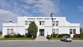
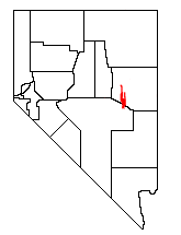
Lincoln County is a county in the U.S. state of Nevada. As of the 2020 census, the population was 4,499, making it the fourth-least populous county in Nevada. Its county seat is Pioche. Like many counties in Nevada, it is dry and sparsely populated, though notable for containing the Area 51 government Air Force base.

Elko County is a county in the northeastern corner of Nevada, United States. As of the 2020 census, the population was 53,702. Its county seat is Elko. The county was established on March 5, 1869, from Lander County.

McDermitt is an unincorporated community straddling the Nevada–Oregon border, in Humboldt County, Nevada, and Malheur County, Oregon, United States. McDermitt's economy has historically been based on mining, ranching, and farming. The last mining operation closed in 1990, resulting in a steady decline in population.

The Reese River is a 181-mile-long (291 km) tributary of the Humboldt River, located in central Nevada in the western United States.
Duckwater is an unincorporated community located in the central portion of the U.S. state of Nevada, in the Duckwater Valley at about the same latitude as Sacramento, California. It is in Nye County, at the eastern edge of the Duckwater Indian Reservation, near the Red Mountain Wilderness at the end of Nevada State Route 379. The city of Las Vegas is about 200 miles (320 km) to the south-southeast.

The Ely Shoshone Indian Reservation is an Indian reservation for the Ely Shoshone Tribe of Nevada, Shoshone people, in and near the south side of the city of Ely in south-central White Pine County, Nevada. In 2005 it had a population of around 500, a textile business, and its own court system. The reservation is quite small, with a land area of only 104.99 acres (0.4249 km2) and a 2000 census official resident population of 133 persons. Part of the city of Ely lies within its territory.

Railroad Valley is one of the Central Nevada Desert Basins in the Tonopah Basin and is about 80 miles (130 km) long north–south and up to 20 miles (32 km) wide, with some southern areas running southwest to northeast.

Ruby Valley is a large basin located in south-central Elko and northern White Pine counties in the northeastern section of the state of Nevada in the western United States. From Secret Pass it runs south-southwest for approximately 60 miles (96 km) to Overland Pass. To the west is the steep escarpment of the Ruby Mountains, and to the north is the East Humboldt Range and Clover Valley. The east side of the valley is less well defined, but its maximum width is about 10 miles (16 km) near Franklin Lake. At its south end lies the Ruby Lake National Wildlife Refuge.
The White Pine Range is a group of mountains in southern White Pine County, in eastern Nevada. The range runs for approximately 51 miles (82 km) from Beck Pass in the north to Currant Pass in the south. To the west of the range are the Duckwater (Shoshone) tribal lands and the northern arm of large Railroad Valley. To the east are Jakes Valley and the northern part of the long White River Valley. To the south are the Horse and Grant Ranges.

The Toquima Range is a mountain range, located primarily in Nye County with a small extension into Lander County, in Nevada, United States. Most of the range is included within the Humboldt-Toiyabe National Forest. The range reaches a maximum elevation of 11,949 feet (3,642 m) at the southern summit of Mount Jefferson. From Hickison Summit on U.S. Route 50, the range runs for approximately 71 miles (114 km) to the south-southwest. To its west are Big Smoky Valley, scenic State Route 376, and the large Toiyabe Range. To the east are remote Monitor Valley and the Monitor Range. Lying to the south of the range are U.S. Route 6 (Nevada) and the community of Tonopah, while to the north is U.S. Route 50, leading to the small community of Austin.

State Route 894 (SR 894), also known as Shoshone Road, is a state highway in southeastern White Pine County, Nevada, United States.
The Paiute-Shoshone Indians of the Lone Pine Community of the Lone Pine Reservation is a federally recognized tribe of Mono and Timbisha Native American Indians near Lone Pine in Inyo County, California. They are related to the Owens Valley Paiute.

The Te-Moak Tribe of Western Shoshone Indians of Nevada is a federally recognized tribe of Western Shoshone people in northeastern Nevada.

The Duckwater Shoshone Tribe of the Duckwater Reservation is a federally recognized tribe of Western Shoshone, based in central Nevada in the high desert Railroad Valley, in northern Nye County. Their autonym is Tsaidüka in their Shoshoni language, meaning "Eaters of tule."
The Yomba Shoshone Tribe of the Yomba Reservation is a federally recognized tribe of Western Shoshone Indians in central Nevada.
Schellbourne, formerly known as Fort Schellbourne and Schell Creek Station is a ghost town located in the Schell Creek Range in White Pine County in Nevada, United States, located 43 miles (69 km) north of Ely. The town was a stopover along the Central Overland Route, Pony Express and original routing of the Lincoln Highway. It is today Nevada Historical Marker number 51. The site was listed on the National Register of Historic Places in 1972. Its boundaries were increased in 1977.
Spring Valley is a long north south trending basin, largely in White Pine County, Nevada and a small portion in the extreme south in Lincoln County, Nevada. It extends from 39°59′00″N114°29′33″W in White Pine County to the north to 38°33′57″N114°21′05″W in the south in Lincoln County. The bottom of the basin is at Yelland Dry Lake at an elevation of 5,551 feet. Bahsahwahbee, a grove of Rocky Mountain juniper trees, locally called swamp cedars, where multiple massacres of Western Shoshone people occurred in the 19th century, lies in Spring Valley. The Spring Valley Wind Farm is to its south.


 Ranches in Shoshone
