
The Town of Montezuma is a statutory town located in eastern Summit County, Colorado, United States. The town population was 74 at 2020 United States Census. The town is a former mining camp that sits at an elevation of 10,200 feet (3,110 m), just west of the Continental Divide, nestled among mountains that reach an elevation of 12,000-13,000 feet around it. It is situated in the upper valley of the Snake River above the ski resort of Keystone in the Rocky Mountains.

Neihart is a town in Cascade County, Montana, United States. It is located in the center of Little Belt Mountains. The population was 43 at the 2020 census. It is part of the Great Falls, Montana, Metropolitan Statistical Area.

Gilman is an abandoned mining town in southeastern Eagle County, Colorado, United States. The U.S. Post Office at Minturn now serves Gilman postal addresses.

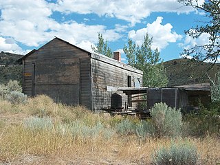
Hamilton is an abandoned mining town located in the White Pine Range, in western White Pine County, Nevada, United States.

Panamint City is a ghost town in the Panamint Range, near Death Valley, in Inyo County, California, US. It is also known by the official Board of Geographic Names as Panamint. Panamint was a boom town founded after silver and copper were found there in 1872. By 1874, the town had a population of about 2,000. Its main street was one mile (1.6 km) long. Panamint had its own newspaper, the Panamint News. Silver was the principal product mined in the area. The town is located about three miles northwest of Sentinel Peak. According to the National Geographic Names Database, NAD27 latitude and longitude for the locale are 36°07′06″N117°05′43″W, and the feature ID number is 1661185. The elevation of this location is identified as being 6,280 feet AMSL. The similar-sounding Panamint Springs, California, is located about 25.8 miles at 306.4 degrees off true north near Panamint Junction.

Tuscarora is an unincorporated community in Elko County, Nevada, United States. The community lies on the east side of the Tuscarora Mountains approximately 40 miles north of Carlin. Tuscarora is part of the Elko Micropolitan Statistical Area. Far from being a ghost town, as several websites proclaim, Tuscarora is home to two schools, a library, a post office and a bar and grill, as well as homes for its very much alive residents.

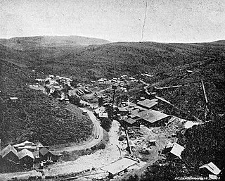
Cherry Creek is a historic mining town located in northern White Pine County, in northeastern Nevada in the western United States. It is a census county division (CCD), with a population at the 2010 census of 72.
The Lost Adams Diggings is a Southwestern treasure story that refers to the existence of a canyon rich in gold deposits somewhere in western New Mexico in the early 1860s.

Bingham Canyon was a city formerly located in southwestern Salt Lake County, Utah, United States, in a narrow canyon on the eastern face of the Oquirrh Mountains. The Bingham Canyon area boomed during the first years of the twentieth century, as rich copper deposits in the canyon began to be developed, and at its peak the city had approximately 15,000 residents. The success of the local mines eventually proved to be the town's undoing, however: by the mid-twentieth century, the huge open-pit Bingham Canyon Mine began encroaching on the land of the community, causing residents to relocate. By the 1970s, almost the entirety of the town had been devoured by the mine, and the few remaining residents voted to disincorporate and abandon the community. No trace of Bingham Canyon remains today.
Kimberly is a ghost town in the northwest corner of Piute County, Utah, United States. Located high in Mill Canyon on the side of Gold Mountain in the Tushar Mountains, Kimberly was formerly a gold mining town. Originally settled in the 1890s, it lasted until 1910. Kimberly had a minor rebirth in the 1930s, but has been uninhabited since approximately 1938. The town is perhaps best known as the birthplace of Ivy Baker Priest, a former United States Treasurer.
Mammoth is an unincorporated community and semi-ghost town in northeastern Juab County, Utah, United States.

Havilah is an unincorporated community in Kern County, California. It is located in the mountains between Walker Basin and the Kern River Valley, 5 miles (8.0 km) south-southwest of Bodfish at an elevation of 3,136 feet (956 m).
La Plata is a ghost town on the southern end of Cache County, Utah, United States. Located in the Bear River Mountains on a small tributary of the east fork of the Little Bear River, La Plata was a short-lived silver mining boomtown in the 1890s.
Sageland is an unincorporated community in Kern County, California. It is located near Kelso Creek 3.5 miles (5.6 km) west-northwest at the base of the Piute Mountains, at an elevation of 4,026 feet (1,227 m).
De Lamar is a ghost town in Owyhee County, Idaho, United States. Its elevation is 5,463 ft (1,665 m), and it is approximately 6 mi (9.7 km) west of Silver City. The community lies within an area governed by the Bureau of Land Management.

Alexandra is a ghost town in Yavapai County, Arizona, United States. The ghost town was settled during the frontier days of 1875 as a mining camp until abandoned in 1896. Alexandra is ten miles east of Mayer.

El Dorado Canyon is a canyon in southern Clark County, Nevada famed for its rich silver and gold mines. The canyon was named in 1857 by steamboat entrepreneur Captain George Alonzo Johnson when gold and silver was discovered here. It drains into the Colorado River at the former site of Nelson's Landing.

Fairview is a ghost town in Churchill County, Nevada, in the United States of America.
Vanderbilt is a ghost town in Eureka County, in the western state of Nevada, in the United States.
Pyramid City is a ghost town located south of Sutcliffe, Nevada. This location was also sometimes known as Pyramid and should not be confused with Pyramid, Nevada, located north of Sutcliffe. Pyramid City consisted of two mining camps, Upper Pyramid and Lower Pyramid, also known as Pyramid City.

