
McDermitt is an unincorporated community straddling the Nevada–Oregon border, in Humboldt County, Nevada, and Malheur County, Oregon, United States. McDermitt's economy has historically been based on mining, ranching, and farming. The last mining operation closed in 1990, resulting in a steady decline in population.

Winnemucca is the only incorporated city in and is the county seat of Humboldt County, Nevada, United States. As of the 2010 census, the city had a total population of 7,396, up 3.1 percent from the 2000 census figure of 7,174. Interstate 80 passes through the city, where it meets U.S. Route 95.

Sarah Winnemucca Hopkins was a Northern Paiute author, activist and educator.

The Black Rock Desert is a semi-arid region (in the Great Basin shrub steppe eco-region), of lava beds and playa, or alkali flats, situated in the Black Rock Desert–High Rock Canyon Emigrant Trails National Conservation Area, a silt playa 100 miles (160 km) north of Reno, Nevada that encompasses more than 300,000 acres (120,000 ha) of land and contains more than 120 miles (200 km) of historic trails. It is in the northern Nevada section of the Great Basin with a lakebed that is a dry remnant of Pleistocene Lake Lahontan.

The Humboldt River is an extensive river drainage system located in north-central Nevada. It extends in a general east-to-west direction from its headwaters in the Jarbidge, Independence, and Ruby Mountains in Elko County, to its terminus in the Humboldt Sink, approximately 225 miles away in northwest Churchill County. Most estimates put the Humboldt River at 290 miles (470 km) long however, due to the extensive meandering nature of the river, its length is more closely estimated at 380 miles (612 km). It is located within the Great Basin Watershed and is the third longest river in the watershed behind the Bear River at 355 miles (570 km) and the Sevier River at 325 miles (523 km). The Humboldt River Basin is the largest sub-basin of the Great Basin encompassing an area of 16,840 square miles. It is the only major river system wholly contained within the state of Nevada.
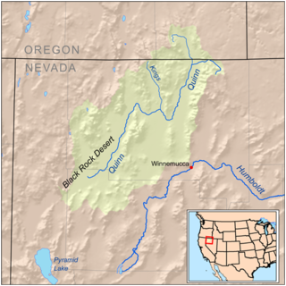
The Quinn River, once known as the Queen River, is an intermittent river, approximately 110 miles (180 km) long, in the desert of northwestern Nevada in the United States. It drains an enclosed basin inside the larger Great Basin.

Mound House, Nevada is a small unincorporated community in Lyon County, Nevada on U.S. Route 50 that is situated between Nevada's capital, Carson City, and Dayton. Its elevation is 4,974 feet (1,516 m). It is in Lyon County, one of eight Nevada counties that allow for legalized prostitution, and is home to four brothels.

Delamar, Nevada, nicknamed The Widowmaker, is a ghost town in central eastern Nevada, USA along the east side of the Delamar Valley. During its heyday, primarily between 1895 and 1900, it produced $13.5 million in gold.

Golconda is a census-designated place in southeastern Humboldt County, Nevada, United States. As of the 2010 census it had a population of 214. It is located along Interstate 80 on the Humboldt River in the northwestern part of the state. Although it is unincorporated, Goldonda has a post office, which has been in operation since 1869.

Imlay is an unincorporated town in Pershing County, Nevada, United States. It has an elementary school, a general store, a post office, and a trading post. As of the 2010 census the population was 171.

Blair, Nevada is a mining ghost town in Esmeralda County, Nevada.

The Jackson Mountains are a north-northeast trending mountain range in southwestern Humboldt County, Nevada. The range is flanked on the west by the Black Rock Desert and the Black Rock Range beyond. To the north across the Quinn River and Nevada State Route 140 lie the Bilk Creek Mountains. To the northeast across Kings River Valley is the Double Mountains and to the east are the Sleeping Hills. To the southeast and south lie the Eugene and Kamma Mountains. The ghost town of Sulphur lies just southwest of the pass between the Jackson and Kamma ranges. Nevada State Route 49 and the Union Pacific railroad Feather River Route traverse this pass.

The Getchell Mine is an underground gold mine in the Potosi Mining District of Humboldt County, Nevada, on the east flank of the Osgood Mountains, 35 miles northeast of Winnemucca. Prospectors Edward Knight and Emmet Chase discovered gold in 1933 and located the first claims in 1934. With the financial backing of Noble Getchell and George Wingfield, the Getchell Mine, Inc. was organized in 1936 and the mine was brought into production in 1938.
The Kamma Mountains are a mountain range in Pershing County and Humboldt County, Nevada. The ghost town and railroad siding at Sulphur, Nevada is on the west side of the Kamma Mountains at the eastern edge of the Black Rock Desert playa.
The Broken Hills, or Broken Hills Range, is a mountain range bordering Churchill County, Nevada and Mineral County, Nevada.

Red Dog was a California gold rush mining town located in the Gold Country in south-central Nevada County, California, United States, 6 mi (9.7 km) northeast of Chicago Park. Red Dog Hill, a mine and campsite, was founded by three men all under the age of 22, and was named by their youngest, a 15-year-old prospector. As mining operations grew, the campsite became a settlement, and then a town with a population of 2,000 residents, before it was eventually abandoned. Still considered important today, Red Dog Townsite is listed on the National Register of Historic Places. Red Dog has been noted for its unusual place name.
Hunt's Hill is a former mining camp in Nevada County, California, United States. Hunt's Hill was located in the Sierra Nevada foothills about 6 miles in a straight line southeast of Nevada City and about 2 miles northwest of You Bet, on the north side of Greenhorn Creek, not far from the present intersection of Red Dog and Buckeye Roads. Hunt’s Hill was founded in 1852 by a miner named Hunt. It was located on one of the deepest parts of the rich Blue Lead channel of gold-bearing gravel. In 1855, one of the mining claims established by some French miners, was “jumped". During the fight, one of the French miners lost an eye. Thereafter, that mine, and sometimes the town, were called Gouge Eye. By 1857, the town boasted two saloons, a hotel, a blacksmith and stable, a butcher shop, a boot and shoe store, and several grocery stores. In 1858, a stage line from Nevada City arrived. In 1866, seven cement mills for extracting gold from the “blue cement” were operating in the area. By 1880, the town was reduced to a combined store and saloon and a few houses. In 1895, one directory summed up the state of the community thus: "At the present time there is not much doing there." Since that same directory identified the town's justice of the peace and constable, what little happened must have been interesting. Today, it is just a historic site.
The Grass Valley of Pershing and Humboldt counties in northern Nevada, United States, is a 30-mile (48 km) long valley. The north section of the valley is part of the southwest portion of Winnemucca on the Humboldt River. Clear Creek flows down the valley center, north-northwesterly and joins the Humboldt at Rose Creek, Nevada, 10 miles (16 km) southwest of Winnemucca. The census-designated place of Grass Valley, with a population of 1,161, occupies the central 8 miles (13 km) of the valley.
Jungo is a ghost town located on Humboldt County Route 55, between Winnemucca, Nevada and Sulphur, Nevada. At one time, Jungo boasted a hotel, store, filling station and blacksmith's shop, though no buildings remain.
Willow Point is an extinct town in Humboldt County, in the U.S. state of Nevada. Willow Point is located in Paradise Valley, south of the town of Paradise Valley and about 20 miles northeast of Winnemucca.


