Denio, Nevada

Last updated

Denio, Nevada
2014-07-06 14 51 51 View of Denio, Nevada from Harney County Route 201 (Fields-Denio Road) a half mile north of the Oregon border.JPG
USA Nevada location map.svg
Red pog.svg
Denio
Usa edcp location map.svg
Red pog.svg
Denio
Coordinates: 41°59′24″N118°37′59″W / 41.99000°N 118.63306°W / 41.99000; -118.63306
Country United States
States Nevada (CDP)
Oregon  (outside CDP)
Counties Humboldt and Harney
Area
[1]
  Total0.46 sq mi (1.19 km2)
  Land0.46 sq mi (1.19 km2)
  Water0.00 sq mi (0.00 km2)
Elevation
[2]
4,206 ft (1,282 m)
Population
 (2020)
  Total34
  Density74.24/sq mi (28.65/km2)
Time zone UTC-8 (Pacific (PST))
  Summer (DST) UTC-7 (PDT)
ZIP code
89404
FIPS code 32-18500
GNIS feature ID845425 [2]

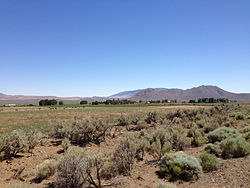
Denio is a census-designated place (CDP) in Humboldt County, Nevada, along the Oregon state line in the United States. [3] The Denio post office was originally north of the state line in Harney County, Oregon, [4] but the residents moved the building into Nevada in the mid-20th century. The population of the CDP, which is entirely in Nevada, was 47 at the 2010 census; [5] additional development considered to be Denio extends into Oregon. The CDP includes a post office, a community center, a library, and the Diamond Inn Bar, the center of the town's social life. [6] Recreational activities in the Denio area include bird watching, photography, off road vehicle use, fishing, recreational black opal mining, rockhounding, hunting, visiting the hot springs, and camping on the Sheldon National Wildlife Refuge. [6]

Contents

Denio Junction is about 3 miles (5 km) south of Denio, at the junction of State Route 140 and State Route 292. [7] Denio Junction's motel provides gas, food, groceries, and lodging. [6] Denio Junction Airport is a two-runway graded airstrip. [8] There is no scheduled air or ground transportation serving this field, which is a short walk from Denio Junction. [8]

History

The Diamond Inn in Denio, 1976 The Old Diamond Inn.jpg
The Diamond Inn in Denio, 1976

Denio was named after Aaron Denio, who settled in the area in 1885. [9] He was born in 1824 in Illinois and traveled to California in 1860. [9] He worked in milling, mining, and farming in Nevada and California for 25 years before settling near the Oregon-Nevada border. [9] He died at Denio in 1907. [9] The Denio post office was established in Oregon in 1888. [9] After World War II a number of businesses relocated south of the state line to take advantage of Nevada's lack of an income tax and more liberal liquor, gambling, and prostitution laws. [9] The post office was moved and reopened in Nevada in 1950 for Nevada addresses, not Oregon. [9]

Education

Public education in Denio (on the Nevada side) is administered by the Humboldt County School District, which operates the Denio School, a three-room kindergarten-eighth grade (K-8) school. [6] It is, more or less, a two-room schoolhouse, and lacks a full-service cafeteria. By design, as per the last twenty years, the school functions to allow teachers more informal, flexible scheduling. [10] There were 20 students in the 1963-1964 school year; [11] likewise, enrollment in December 2004 was also 20 students. [10]

As of 2004, Denio, Nevada students of high school age may attend Humboldt County School District's Albert M. Lowry High School (in Winnemucca, Nevada); additionally, parents of high school-aged children who decide to attend Lowry High School may relocate to Winnemucca for the duration of their children’s time as a student there. High schoolers may also attend Crane Union High School, a public boarding high school in Crane, Oregon. [10] The Oregon side (across from Denio, Nevada) is, as of 2020, zoned to South Harney School District 33 (Fields School, K-8) and Harney County Union High School District 1J (the district for Crane Union). [12] The Denio, Oregon, community was historically served by Crane Union, with the high school taking in several Basque Oregonians from there. [13]

Denio has a public library, a branch of the Humboldt County Library. [14]

Humboldt County is in the service area of Great Basin College. [15] That college maintains the GBC Center in Winnemucca. [16] Harney County is not in a community college district but has a "contract out of district" (COD) with Treasure Valley Community College. [17] TVCC operates the Burns Outreach Center in Burns. [18]

Climate

Climate data for Denio, Nevada (1991–2020 normals, extremes 1951–2017)
MonthJanFebMarAprMayJunJulAugSepOctNovDecYear
Record high °F (°C)67
(19)
76
(24)
78
(26)
93
(34)
97
(36)
105
(41)
107
(42)
107
(42)
103
(39)
97
(36)
72
(22)
64
(18)
107
(42)
Mean maximum °F (°C)53.8
(12.1)
58.9
(14.9)
69.0
(20.6)
80.1
(26.7)
88.5
(31.4)
95.1
(35.1)
101.1
(38.4)
100.2
(37.9)
92.3
(33.5)
83.1
(28.4)
66.2
(19.0)
53.9
(12.2)
102.1
(38.9)
Mean daily maximum °F (°C)43.6
(6.4)
48.7
(9.3)
57.6
(14.2)
64.1
(17.8)
73.6
(23.1)
83.8
(28.8)
94.3
(34.6)
92.9
(33.8)
83.2
(28.4)
68.6
(20.3)
52.6
(11.4)
42.4
(5.8)
67.1
(19.5)
Daily mean °F (°C)32.7
(0.4)
36.4
(2.4)
43.2
(6.2)
47.8
(8.8)
56.2
(13.4)
64.7
(18.2)
73.9
(23.3)
72.2
(22.3)
62.9
(17.2)
51.2
(10.7)
39.5
(4.2)
32.0
(0.0)
51.1
(10.6)
Mean daily minimum °F (°C)21.7
(−5.7)
24.0
(−4.4)
28.7
(−1.8)
31.5
(−0.3)
38.8
(3.8)
45.7
(7.6)
53.5
(11.9)
51.5
(10.8)
42.6
(5.9)
33.8
(1.0)
26.4
(−3.1)
21.6
(−5.8)
35.0
(1.7)
Mean minimum °F (°C)3.5
(−15.8)
8.2
(−13.2)
15.2
(−9.3)
17.6
(−8.0)
23.8
(−4.6)
32.8
(0.4)
40.4
(4.7)
38.3
(3.5)
27.6
(−2.4)
17.1
(−8.3)
9.3
(−12.6)
2.1
(−16.6)
−2.9
(−19.4)
Record low °F (°C)−21
(−29)
−21
(−29)
0
(−18)
11
(−12)
14
(−10)
22
(−6)
29
(−2)
26
(−3)
17
(−8)
−2
(−19)
−4
(−20)
−25
(−32)
−25
(−32)
Average precipitation inches (mm)0.73
(19)
0.82
(21)
0.98
(25)
1.00
(25)
1.36
(35)
0.76
(19)
0.25
(6.4)
0.30
(7.6)
0.29
(7.4)
0.65
(17)
0.77
(20)
1.19
(30)
9.10
(231)
Average snowfall inches (cm)5.7
(14)
2.3
(5.8)
1.3
(3.3)
1.5
(3.8)
0.1
(0.25)
0.0
(0.0)
0.0
(0.0)
0.0
(0.0)
0.0
(0.0)
0.6
(1.5)
1.0
(2.5)
7.3
(19)
19.8
(50)
Average precipitation days (≥ 0.01 in)5.45.07.16.96.74.51.71.72.44.34.96.256.8
Average snowy days (≥ 0.1 in)2.31.50.80.60.00.00.00.00.00.31.12.59.1
Source: NOAA (mean maxima/minima 19812010) [19] [20]

Demographics

Historical population
CensusPop.Note
2020 34
U.S. Decennial Census [21]

See also

Related Research Articles

<span class="mw-page-title-main">Harney County, Oregon</span> County in Oregon, United States

Harney County is one of the 36 counties in the U.S. state of Oregon. As of the 2020 census, the population was 7,495, making it the sixth-least populous county in Oregon. The county seat is Burns. Established in 1889, the county is named in honor of William S. Harney, a military officer of the period, who was involved in the Pig War and popular in the Pacific Northwest.

<span class="mw-page-title-main">Humboldt County, Nevada</span> County in Nevada, United States

Humboldt County is a county in the U.S. state of Nevada. As of the 2020 Census, the population was 17,285. It is a largely rural county that is sparsely populated with the only major city being Winnemucca which has a population of 8,431. Humboldt County comprises the Winnemucca, NV Micropolitan Statistical Area and serves as an important crossroads in the national transportation network. Interstate 80 travels through the southeastern corner of the county, meeting US 95 in Winnemucca that serves as a primary freight corridor between Northern Nevada and Boise, Idaho and the Interstate 84 freight corridor that links much of the Pacific Northwest. The original transcontinental railway, constructed by the Central Pacific Railroad, reached Humboldt County on Sept. 16, 1868. The Western Pacific Railroad would reach Humboldt County by November 1909, providing two mainline rail links to California and the Eastern United States. Both railroads have since been acquired by the Union Pacific Railroad, who continues to serve the region today.

<span class="mw-page-title-main">McDermitt, Nevada and Oregon</span> Unincorporated community in the state of Nevada, United States

McDermitt is an unincorporated community straddling the Nevada–Oregon border, in Humboldt County, Nevada, and Malheur County, Oregon, United States. McDermitt's economy has historically been based on mining, ranching, and farming. The last mining operation closed in 1990, resulting in a steady decline in population.

<span class="mw-page-title-main">Winnemucca, Nevada</span> City in Nevada, United States

Winnemucca is the only incorporated city in, and is the county seat of, Humboldt County, Nevada, United States. As of the 2020 census, the city had a total population of 8,431, up 14.0 percent from the 2010 census figure of 7,396. Interstate 80 passes through the city, where it meets U.S. Route 95.

<span class="mw-page-title-main">Riley, Oregon</span> Unincorporated town in Oregon, United States

Riley is an unincorporated community in Harney County, Oregon, United States, located at the crossroads of U.S. Highway 395 and U.S. Highway 20, milepost 104, about 28 miles (45 km) west of Burns, the seat of Harney County. The elevation of Riley is 4,226 feet (1,288 m). The town presently consists entirely of two service establishments with attached apartments: a post office, and a general store with gas pump and garage service. It exists to serve the rural farming and ranching community that surrounds it, and highway travelers.

<span class="mw-page-title-main">Frenchglen, Oregon</span> Unincorporated community in the state of Oregon, United States

Frenchglen is an unincorporated community in Harney County, Oregon, United States. It is 60 miles (97 km) south of Burns on Oregon Route 205 and its population is approximately 12.

<span class="mw-page-title-main">Paradise Valley, Nevada</span> Census-designated place in Nevada, United States

Paradise Valley is a census-designated place (CDP) in Humboldt County, Nevada, United States, near the Santa Rosa Ranger District of Humboldt National Forest. It is located at the northern terminus of Nevada State Route 290, about 19 miles (31 km) northeast of U.S. Highway 95 and a total of 40 miles (64 km) north of Winnemucca. The town is located in a broad valley, with the Santa Rosa Range of mountains just to the northwest. At the 2010 census, the population of the CDP was 109.

<span class="mw-page-title-main">Drewsey, Oregon</span> Unincorporated community in the state of Oregon, United States

Drewsey is an unincorporated community in Harney County, in the U.S. state of Oregon. Drewsey is along the main stem of the Malheur River, about 45 miles (72 km) east of Burns, off U.S. Route 20. It has the ZIP Code of 97904.

<span class="mw-page-title-main">Nevada State Route 140</span> State highway in Humboldt County, Nevada, United States

State Route 140 is a two-lane state highway in Humboldt County, Nevada. It serves a sparsely populated section of the state, connecting northwestern Nevada to southern Oregon. Most of the highway was originally part of State Route 8A, and was later improved through an effort to provide an all-weather highway linking northern Nevada to the Pacific Northwest.

<span class="mw-page-title-main">Orovada, Nevada</span> Census-designated place in Nevada, United States

Orovada is a census-designated place in Humboldt County, Nevada. The population was 155 at the 2010 census.

<span class="mw-page-title-main">Nevada State Route 292</span> State highway in Nevada, United States

State Route 292 is a short state highway on the northern edge of Humboldt County, Nevada, United States, that serves the community of Denio.

<span class="mw-page-title-main">Crane, Oregon</span> Unincorporated community in the state of Oregon, United States

Crane is a census-designated place and unincorporated community in Harney County, Oregon, United States, northeast of Malheur Lake on Oregon Route 78. Its population was 116 at the 2020 census.

<span class="mw-page-title-main">Crane Union High School</span> Public school in Crane, , Oregon, United States

Crane Union High School is a public high school in Crane, Oregon, United States. It is a boarding school that serves students from a large geographic area.

<span class="mw-page-title-main">Fields, Oregon</span> Unincorporated community in the state of Oregon, United States

Fields is an unincorporated community in Harney County, Oregon, United States, located 112 miles (180 km) south of Burns. It is the center of commerce for local ranches and the largest community between Denio, Nevada, 22 miles (35 km) to the south, and Frenchglen, Oregon, 52.4 miles (84.3 km) to the north.

<span class="mw-page-title-main">Diamond, Oregon</span> Unincorporated community in the state of Oregon, United States

Diamond is an unincorporated community in Harney County, Oregon, United States. Diamond is west of Oregon Route 205 and south of Malheur Lake, 52 miles (84 km) south-southeast of Burns by highway. Its post office is assigned ZIP code 97722.

<span class="mw-page-title-main">Lawen, Oregon</span> Unincorporated community in the state of Oregon, United States

Lawen is an unincorporated community in Harney County, Oregon, United States. It has a post office with a ZIP code 97720. Lawen lies along Oregon Route 78 just south of its interchanges with Oregon Route 205, U.S. Route 20, and U.S. Route 395 in Burns, the county seat. Lawen is just north of the East Fork Silvies River and Malheur Lake.

<span class="mw-page-title-main">Humboldt County School District</span> School district in Nevada, United States

The Humboldt County School District is a public school district serving K−12 education in Humboldt County, Nevada, in the northwestern part of the state.

Suntex is the name of an unincorporated community in Harney County, in the U.S. state of Oregon. It was established with the placement of a post office in the valley of Silver Creek west of Burns and north of U.S. Route 20.

McDermitt Combined School or McDermitt Combined Schools is a K-12 school in McDermitt, on the boundary of Nevada and Oregon, in the United States. The school is a part of Humboldt County School District of Nevada.

References

  1. "ArcGIS REST Services Directory". United States Census Bureau. Retrieved September 19, 2022.
  2. 1 2 U.S. Geological Survey Geographic Names Information System: Denio, Nevada
  3. "Denio". Geographic Names Information System . United States Geological Survey, United States Department of the Interior. December 12, 1980. Retrieved March 27, 2012.
  4. "Denio Post Office (historical)". Geographic Names Information System . United States Geological Survey, United States Department of the Interior. August 1, 1994. Retrieved March 27, 2012.
  5. "Geographic Identifiers: 2010 Demographic Profile Data (G001): Denio CDP, Nevada". U.S. Census Bureau, American Factfinder. Archived from the original on February 12, 2020. Retrieved January 24, 2013.
  6. 1 2 3 4 "Denio, Nevada". travelNevada.com. Nevada Commission on Tourism. Archived from the original on February 4, 2013. Retrieved March 27, 2012.
  7. "Denio Junction". Geographic Names Information System . United States Geological Survey, United States Department of the Interior. December 12, 1980. Retrieved March 27, 2012.
  8. 1 2 "Denio Junction Airport". airnav.com. Retrieved July 22, 2014.
  9. 1 2 3 4 5 6 7 McArthur, Lewis A.; McArthur, Lewis L. (2003) [1928]. Oregon Geographic Names (7th ed.). Portland, Oregon: Oregon Historical Society Press. p. 278. ISBN   978-0875952772.
  10. 1 2 3 Roccapriore, Carla (December 12, 2004). "Tiny-town students visit biggest little city". Reno Gazette-Journal . pp. 1C, 2C. - Clipping of first and of second page at Newspapers.com. "a public boarding school in Crane, Ore." automatically refers to Crane Union HS, as it is the only boarding school in Crane.
  11. "Humboldt School Enrollment Gains". Reno Gazette-Journal . September 11, 1963. p. 2. - Clipping from Newspapers.com.
  12. "2020 CENSUS - SCHOOL DISTRICT REFERENCE MAP: Harney County, OR" (PDF). U.S. Census Bureau . Retrieved July 15, 2022. - Text list
  13. "They 'Live In' at Crane". Sunday Journal Magazine . November 12, 1950. Archived from the original on October 10, 2006. Retrieved July 15, 2022.
  14. "Nevada Public Libraries". PublicLibraries.com. Retrieved June 14, 2019.
  15. "Data and Information". Great Basin College . Retrieved March 10, 2024.
  16. "GBC Center in Winnemucca". Great Basin College . Retrieved March 10, 2024. 5490 Kluncy Canyon Road Winnemucca, NV 89445
  17. "Oregon Community Colleges and Community College Districts" (PDF). Oregon Department of Community Colleges & Workforce Development . Retrieved July 17, 2022.
  18. "Burns Outreach Center". Treasure Valley Community College . Retrieved July 17, 2022.
  19. "NOWData – NOAA Online Weather Data". National Oceanic and Atmospheric Administration. Retrieved December 9, 2023.
  20. "Summary of Monthly Normals 1991–2020". National Oceanic and Atmospheric Administration. Retrieved December 9, 2023.
  21. "Census of Population and Housing". Census.gov. Retrieved June 4, 2016.

Further reading