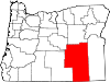
Wadadökadö or Wadatika (Waadadikady): "Wada Root and Grass-seed Eaters", also known as Harney Valley Paiute, they controlled about 52,500 square miles (136,000km2) along the shores of Malheur Lake, between the Cascade Range in central Oregon and the Payette Valley north of Boise, Idaho, as well as in the southern parts of the Blue Mountains in the vicinity of the headwaters of the Powder River, north of the John Day River, southward to the desertlike surroundings of Steens Mountain. They are federally recognized as part of the Burns Paiute Tribe and part of the Confederated Tribes of Warm Springs. The tribe received federal recognition in 1968.[3]
Hunipuitöka or Walpapi: "Hunipui-Root-Eaters", often called Snake Indians, they lived along Deschutes River, Crooked River and John Day River in Central Oregon. They are federally recognized as part of the Burns Paiute Tribe.
Reservation
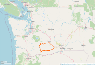
Location of Burns Paiute ReservationSign for the "Paiute Indian Reservation" in Burns
The tribe owns 13,736 acres (55.59km2) in acres in reservation and trust land, all of it in Harney County, Oregon.[4] The tribe also holds about 10 acres (40,000m2) (the "Old Camp"), located about a half-mile west of Burns.[3] The tribe also holds 71 scattered allotments about 25 miles (40km) east of the Burns city limits.[3]
The tribe's reservation is the Burns Paiute Reservation and Trust Lands,[5] also known as the Burns Paiute Indian Colony, located north of the city of Burns.[2]
The tribe's reservation, split into two tracts, was established by Public Law 92-488 on October 13, 1972.[3] In 1935, an additional 760.32 acres (3.0769km2) acres was purchased for the tribe under Section 208 of the National Industrial Recovery Act of 1933; this land lies northwest of the City of Burns.[3]
Demographics
Tribal flag flying at the Walk of Flags near the State Capitol
In 1990, 151 tribal members lived on the reservation; in 1992, 356 people were enrolled in the tribe.[5]
In 2008, there were 341 enrolled members of the tribe (about a third of whom lived on the reservation), making them the smallest federally recognized tribe in Oregon.[3]
According to the Oregon Blue Book (accessed in January 2016), there are 349 members of the tribe.[1]
Tribal members have taken part in an oral history project to gather memories of tribal elders.[3]
The tribe celebrates an Annual Mother's Day Powwow. The tribe also celebrates its Reservation Day Festival and Powwow on October 13 each year, in honor of the anniversary of the date when the land held in trust for the tribe became a reservation.[1][3]
Tribal government and employees
Tribal police
The Constitution and Bylaws of the Burns Paiute Colony was adopted on May 16, 1968.[7] The Constitution and Bylaws created the General Council, a body consisting of all qualified voters (i.e., tribal members 18 years of age or older who live on the reservation or are absentee voters).[7] The General Council meets twice a year for deliberation and voting on matters of importance.[7]
The General Council also nominates and elects a seven-person tribal council to handle the day-to-day affairs of the tribe.[7] The tribal council meets several times a month, and council members serve three-year terms.[7] (The tribal council was created by an amendment to the Constitution and Bylaws in 1988; the council replaced a five-member business council).[7] The council consists of a chair, vice-chair, secretary, sergeant at arms, and three members at large.[1]
There is a tribal police force and tribal court,[3] consisting of a tribal judge and associate judge.[1]
According to the Oregon Blue Book, the tribe employs 54 people.[1] Tribal employees are organized into nine departments, each dealing with a particular area, such as health, education, the environment and energy, cultural preservation and enhancement, and law enforcement.[7]
In 2009, the tribe became the first Native American community to complete full weatherization and installation of energy-efficient lightbulbs in all reservation housing.[3]
For economic development, the Burns Paiute created the Old Camp Casino outside Burns. The facility was 17,000 square feet (1,600m2) in area and opened in 1998.[3] It included a casino, the Sa-Wa-Be Restaurant, a bingo hall, an arcade, a gift shop, conference facilities, an RV park, and other amenities.[1][2][3] The tribe closed the casino on November 26, 2012, due to safety concerns stemming from structural problems with the building.[8]
Related Research Articles
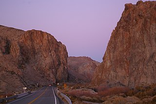
Harney County is one of the 36 counties in the U.S. state of Oregon. As of the 2020 census, the population was 7,495, making it the sixth-least populous county in Oregon. The county seat is Burns. Established in 1889, the county is named in honor of William S. Harney, a military officer of the period, who was involved in the Pig War and popular in the Pacific Northwest.
Burns is a city in and the county seat of Harney County, in the U.S. state of Oregon. According to the 2020 census, the population was 2,730. Burns and the nearby city of Hines are home to about 60 percent of the people in the sparsely populated county, by area the largest in Oregon and the ninth largest in the United States.
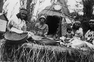
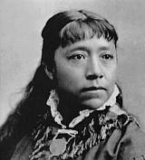
The Northern Paiute people are a Numic people that has traditionally lived in the Great Basin region of the United States in what is now eastern California, western Nevada, and southeast Oregon. The Northern Paiute pre-contact lifestyle was well adapted to the harsh desert environment in which they lived. Each tribe or band occupied a specific territory, generally centered on a lake or wetland that supplied fish and waterfowl. Communal hunt drives, which often involved neighboring bands, would take rabbits and pronghorn from surrounding areas. Individuals and families appear to have moved freely among the bands.
The Yakama Indian Reservation is a Native American reservation in Washington state of the federally recognized tribe known as the Confederated Tribes and Bands of the Yakama Nation. The tribe is made up of Klikitat, Palus, Wallawalla, Wenatchi, Wishram, and Yakama peoples.
The Shoshone or Shoshoni are a Native American tribe with four large cultural/linguistic divisions:
The Confederated Tribes of the Grand Ronde Community of Oregon (CTGR) is a federally recognized tribe of Indigenous peoples of the Northwest Plateau. They consist of at least 27 Native American tribes with long historical ties to present-day western Oregon between the western boundary of the Oregon Coast and the eastern boundary of the Cascade Range, and the northern boundary of southwestern Washington and the southern boundary of northern California.
The Confederated Tribes of Warm Springs is a federally recognized Native American tribe made of three tribes who put together a confederation. They live on and govern the Warm Springs Indian Reservation in the U.S. state of Oregon.
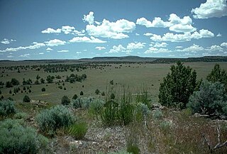
The Oregon High Desert is a region of the U.S. state of Oregon located east of the Cascade Range and south of the Blue Mountains, in the central and eastern parts of the state. Divided into a southern region and a northern region, the desert covers most of five Oregon counties and averages 4,000 feet (1,200 m) above sea level. The southwest region is part of the Great Basin and the southeast is the lower Owyhee River watershed. The northern region is part of the Columbia Plateau, where higher levels of rainfall allow the largest industry on private land to be the cultivation of alfalfa and hay. Public land within the region is owned primarily by the Bureau of Land Management, which manages more than 30,000 square miles (78,000 km2) including five rivers designated as Wild and Scenic.
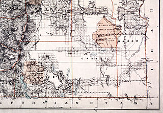
The Malheur Indian Reservation was an American Indian reservation established for the Northern Paiute in eastern Oregon and northern Nevada from 1872 to 1879. The federal government discontinued the reservation after the Bannock War of 1878, under pressure from European-American settlers who wanted the land. This negative recommendation against continuing by its agent William V. Rinehart, led to the internment of more than 500 Paiute on the Yakama Indian Reservation, as well as the reluctance of the Bannock and Paiute to return to the lands after the war.
The Cold Springs Rancheria of Mono Indians of California is a federally recognized tribe of Mono Native Americans. Cold Springs Rancheria is the tribe's reservation, which is located in Fresno County, California. As of the 2010 Census the population was 184.
The Tule River Indian Tribe of the Tule River Reservation is a federally recognized tribe of Native Americans. The Tule River Reservation is located in Tulare County, California. The reservation was made up of Yokuts, about 200 Yowlumne, Wukchumnis, and Western Mono and Tübatulabal. Tribal enrollment today is approximately 1,857 with 1,033 living on the Reservation.
The Bridgeport Indian Colony of California, formerly known as the "Bridgeport Paiute Indian Colony of California", is a federally recognized tribe of Northern Paiute Indians in Mono County, California, United States.
The Bishop Paiute Tribe, formerly known as the Paiute-Shoshone Indians of the Bishop Community of the Bishop Colony is a federally recognized tribe of Mono and Timbisha Indians of the Owens Valley, in Inyo County of eastern California. As of 2022, the United States census showed the Bishop Paiute Tribe's population at 1,914.
The Summit Lake Paiute Tribe of Nevada is a federally recognized tribe of Northern Paiute Indians in northwest Nevada. Their autonym in their language is Agai Panina Ticutta, meaning "Fish Lake Eaters." They are traditionally known as the "Fish Eaters."
The Winnemucca Indian Colony of Nevada is a federally recognized tribe of Western Shoshone and Northern Paiute Indians in northwestern Nevada.
The Yerington Paiute Tribe of the Yerington Colony and Campbell Ranch is a federally recognized tribe of Northern Paiute Indians in western Nevada.
The Las Vegas Tribe of Paiute Indians of the Las Vegas Indian Colony is a federally recognized tribe of Southern Paiute Indians in Southern Nevada.
The Fort McDermitt Paiute and Shoshone Tribe is a federally recognized tribe of Northern Paiute and Western Shoshone peoples, whose reservation Fort McDermitt Paiute and Shoshone Tribes of the Fort McDermitt Indian Reservation spans the Nevada and Oregon border next to Idaho. The reservation has 16,354 acres (6,618 ha) in Nevada and 19,000 acres (7,700 ha) in Oregon.
This page is based on this Wikipedia article Text is available under the CC BY-SA 4.0 license; additional terms may apply. Images, videos and audio are available under their respective licenses.