Umatilla County is one of the 36 counties in the U.S. state of Oregon. The population of 81,826 ranks it as the 14th largest in Oregon, and largest in Eastern Oregon. Hermiston is the largest city in Umatilla County, but Pendleton remains the county seat. Umatilla County is part of the Hermiston-Pendleton, OR Micropolitan Statistical Area, which has a combined population of 94,833. It is included in the eight-county definition of Eastern Oregon.

Pendleton is a city in and the county seat of Umatilla County, Oregon, United States. The population was 17,107 at the time of the 2020 census, which includes approximately 1,600 people who are incarcerated at Eastern Oregon Correctional Institution.

Umatilla is a city in Umatilla County, Oregon, United States. The population in 2010 was 6,906, but the city's population includes approximately 2,000 inmates incarcerated at Two Rivers Correctional Institution.

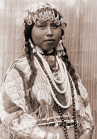
Walla Walla, Walawalałáma, sometimes Walúulapam, are a Sahaptin Indigenous people of the Northwest Plateau. The duplication in their name expresses the diminutive form. The name Walla Walla is translated several ways but most often as "many waters".

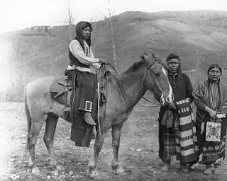
The Cayuse are a Native American tribe in what is now the state of Oregon in the United States. The Cayuse tribe shares a reservation and government in northeastern Oregon with the Umatilla and the Walla Walla tribes as part of the Confederated Tribes of the Umatilla Indian Reservation. The reservation is located near Pendleton, Oregon, at the base of the Blue Mountains.

The Blue Mountains are a mountain range in the northwestern United States, located largely in northeastern Oregon and stretching into extreme southeastern Washington. The range has an area of about 15,000 square miles (39,000 km2), stretching east and southeast of Pendleton, Oregon, to the Snake River along the Oregon–Idaho border.
The Palouse are a Sahaptin tribe recognized in the Treaty of 1855 with the United States along with the Yakama. It was negotiated at the 1855 Walla Walla Council. A variant spelling is Palus. Today they are enrolled in the federally recognized Confederated Tribes and Bands of the Yakama Nation and some are also represented by the Colville Confederated Tribes, the Confederated Tribes of the Umatilla Indian Reservation and Nez Perce Tribe.
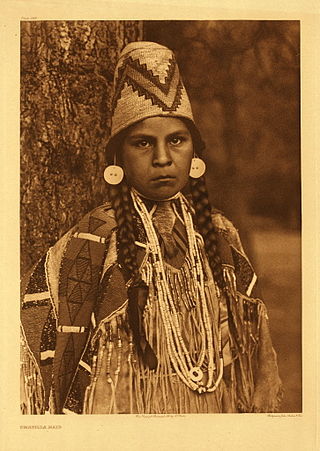
The Umatilla are a Sahaptin-speaking Native American tribe who traditionally inhabited the Columbia Plateau region of the northwestern United States, along the Umatilla and Columbia rivers.

The Confederated Tribes of the Umatilla Indian Reservation are the federally recognized confederations of three Sahaptin-speaking Native American tribes who traditionally inhabited the Columbia River Plateau region: the Cayuse, Umatilla, and Walla Walla.

The Tamástslikt Cultural Institute is a museum and research institute located on the Umatilla Indian Reservation near Pendleton in eastern Oregon. It is the only Native American museum along the Oregon Trail. The institute is dedicated to the culture of the Cayuse, Umatilla, and Walla Walla tribes of Native Americans. The main permanent exhibition of the museum provides a history of the culture of three tribes, and of the reservation itself. The museum also has a second hall for temporary exhibitions of specific types of Native American art, craftwork, history, and folklore related to the tribes.
The Cayuse War was an armed conflict that took place in the Northwestern United States from 1847 to 1855 between the Cayuse people of the region and the United States Government and local American settlers. Caused in part by the influx of disease and settlers to the region, the immediate start of the conflict occurred in 1847 when the Whitman massacre took place at the Whitman Mission near present-day Walla Walla, Washington when thirteen people were killed in and around the mission. Over the next few years the Provisional Government of Oregon and later the United States Army battled the Native Americans east of the Cascades. This was the first of several wars between the Native Americans and American settlers in that region that would lead to the negotiations between the United States and Native Americans of the Columbia Plateau, creating a number of Indian reservations.
Lee Moorhouse (1850–1926) of Pendleton, Oregon, United States, was a photographer and an Indian agent for the Umatilla Indian Reservation. From 1888 to 1916, he produced over 9,000 images documenting urban, rural, and Native American life in the Columbia Basin, and particularly Umatilla County, Oregon.
Wasco-Wishram are two closely related Chinook Indian tribes from the Columbia River in Oregon. Today the tribes are part of the Confederated Tribes of Warm Springs living in the Warm Springs Indian Reservation in Oregon and Confederated Tribes and Bands of the Yakama Nation living in the Yakama Indian Reservation in Washington.

The Umatilla River is an 89-mile (143 km) tributary of the Columbia River in northern Umatilla County, Oregon, United States. Draining a basin of 2,450 square miles (6,300 km2), it enters the Columbia near the city of Umatilla in the northeastern part of the state. In downstream order, beginning at the headwaters, major tributaries of the Umatilla River are the North Fork Umatilla River and the South Fork Umatilla River, then Meacham, McKay, Birch, and Butter creeks.
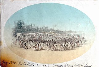
The Walla Walla Council (1855) was a meeting in the Pacific Northwest between the United States and sovereign tribal nations of the Cayuse, Nez Perce, Umatilla, Walla Walla, and Yakama. The council occurred on May 29 – June 11; the treaties signed at this council on June 9 were ratified by the U.S. Senate four years later in 1859.

Wildhorse Resort & Casino is a casino owned and operated since 1994 by the Confederated Tribes of the Umatilla Indian Reservation in the U.S. state of Oregon. It is located 5 mi (8 km) east of Pendleton, on the Umatilla Indian Reservation, near Interstate 84.

Fort Henrietta Historic Park is a public urban park, located in the city of Echo, Oregon, United States. The park is located on the east bank of the Umatilla River and overlooks the original site of Utilla Indian Agency, the first agency for the Umatilla, Cayuse and Walla Walla Indian tribes in 1855 the Oregon Mounted Volunteers built Fort Henrietta on the agency site. The fort and agency were on the west river bank. The park is named for the fort which was named for Henrietta Haller, wife of Major Granville O. Haller, an American military officer during the Cayuse War.

Charles F. Sams III is an American conservationist who is the 19th and current director of the National Park Service since 2021. A member of the Northwest Power and Conservation Council, Sams is the first Native American to serve as head of the NPS.
Roberta "Bobbie" Conner, also known as Sísaawipam, is a tribal historian, activist, and indigenous leader who traces her ancestry to the Umatilla, Cayuse, and Nez Perce tribes. Conner is known for her work as the Director of the Tamástslikt Cultural Institute in Pendleton, Oregon, which seeks to protect, preserve, and promote the culture of the Umatilla, Cayuse, and Walla Walla peoples. In her role at the Tamástslikt Cultural Institute Conner has worked to educate the public on and preserve Indigenous culture through the "We Are," "We Were," and "We Will Be" series of exhibits, and has mentored young scholars interested in tribal cultural preservation. Conner has also sought to educate the public and fight for Native American rights in her personal life as an activist, with a special emphasis on the impact of the division into Tribal Nations and segregation into boarding schools on indigenous cultures, tribal land rights, sustainability, and the repatriation of human remains and funerary objects to Native American lands.