McKay, Oregon | |
|---|---|
 McKay, Oregon  McKay, Oregon | |
| Coordinates: 45°30′27″N118°41′16″W / 45.50750°N 118.68778°W | |
| Country | United States |
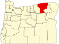
| State | Oregon |
| County | Umatilla |
| Elevation | 1,923 ft (586 m) |
| Time zone | UTC-8 (Pacific (PST)) |
| • Summer (DST) | UTC-7 (PDT) |
| ZIP code | 97868 |
| Area codes | 458 and 541 |
| GNIS feature ID | 2805456 [1] |
McKay is an unincorporated community in Umatilla County, Oregon, United States. [2] Its name accompanies McKay Creek, which is named for Dr. William Cameron McKay, [3] located in Umatilla County at North McKay Creek Road (County 1050 Rd.) on Ross Road.
It has been the site of discovery of ancient bird fossils. [4]