Riverview, Oregon | |
|---|---|
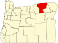
 Riverview, Oregon Location within the state of Oregon | |
| Coordinates: 45°55′09″N119°11′47″W / 45.91917°N 119.19639°W | |
| Country | United States |
| State | Oregon |
| County | Umatilla |
| Elevation | 417 ft (127 m) |
| Time zone | UTC-8 (Pacific (PST)) |
| • Summer (DST) | UTC-7 (PDT) |
| Area codes | 458 and 541 |
| GNIS feature ID | 1167815 [1] |
| Coordinates and elevation from Geographic Names Information System | |
Riverview is an unincorporated historic community in Umatilla County, Oregon, United States. [1] [2] Riverview was a station of the Union Pacific Railroad, [1] [3] near the Columbia River and north of U.S. Route 730.