Myrick, Oregon

Last updated

Myrick, Oregon
USA Oregon location map.svg
Red pog.svg
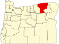
Myrick, Oregon
Location within the state of Oregon
Usa edcp location map.svg
Red pog.svg
Myrick, Oregon
Myrick, Oregon (the United States)
Coordinates: 45°48′15″N118°42′52″W / 45.80417°N 118.71444°W / 45.80417; -118.71444
Country United States
State Oregon
County Umatilla
Elevation
1,719 ft (524 m)
Time zone UTC-8 (Pacific (PST))
  Summer (DST) UTC-7 (PDT)
Area code(s) 458 and 541
GNIS feature ID1637853 [1]
Coordinates and elevation from Geographic Names Information System

Myrick is an unincorporated historic community in Umatilla County, Oregon, United States. [1] It is between Pendleton and Helix, just south of Oregon Route 334. [2]

Myrick is a station on the Burlington Northern Railroad that was originally named "Warren". [3] Because of the confusion with Warren in Columbia County, the name was changed to honor Samuel Jackson Myrick, who came to Oregon from Missouri in 1884 and settled in the area. [3] Myrick post office ran from 1902 to 1908. [3] John Myrick was the first postmaster. [3]

The Myrick family became successful wheat farmers in the area. [4]

Related Research Articles

Sams Valley is an unincorporated community in Jackson County, Oregon, United States. It lies along Oregon Route 234 northeast of Gold Hill, in the Medford area.

<span class="mw-page-title-main">Warren, Oregon</span> Unincorporated community in the state of Oregon, United States

Warren is an unincorporated community and census-designated place in Columbia County, Oregon, United States, located on U.S. Route 30 north of Scappoose and south of St. Helens on Scappoose Bay of the Multnomah Channel. As of the 2010 census it had a population of 1,787.

<span class="mw-page-title-main">Rock Point, Oregon</span> Unincorporated community in the state of Oregon, United States

Rock Point is an unincorporated community in Jackson County, Oregon, United States. Rock Point lies just north of an I-5 and Oregon Route 99 interchange along the Rogue River between the cities of Rogue River and Gold Hill.

<span class="mw-page-title-main">New Princeton, Oregon</span> Unincorporated community in the state of Oregon, United States

New Princeton is an unincorporated community in Harney County, in the U.S. state of Oregon. It is along Oregon Route 78 between Burns and Burns Junction at an elevation of 4,111 feet (1,253 m) above sea level. The South Fork Malheur River begins near Round Mountain, southeast of New Princeton.

Cold Springs is an unincorporated community in Umatilla County, Oregon, United States, south of the Columbia River in the Hermiston area. Cold Springs Junction is a populated place and highway junction about 4 miles (6 km) northeast of Cold Springs at the junction of Oregon Route 37 and U.S. Route 730.

<span class="mw-page-title-main">Lancaster, Oregon</span> Unincorporated community in the state of Oregon, United States

Lancaster is an unincorporated community in Lane County, Oregon, United States. It is located about two miles south of Harrisburg and two miles north of Junction City, on Oregon Route 99E near the Willamette River.

<span class="mw-page-title-main">Idaville, Oregon</span> Unincorporated community in the state of Oregon, United States

Idaville is a census-designated place and unincorporated community in Tillamook County, Oregon, United States. It was founded around the year 1870 by Warren N. Vaughn and named for his daughter Ida. The post office was established in 1922 and closed five years later, in 1927.

<span class="mw-page-title-main">Greenville, Washington County, Oregon</span>

Greenville is an unincorporated historic community in Washington County, Oregon, United States. It is located approximately two miles south of Banks on Oregon Route 47.

<span class="mw-page-title-main">Hauser, Oregon</span> Unincorporated community in the state of Oregon, United States

Hauser is an unincorporated community in Coos County, Oregon, United States. It is along U.S. Route 101, 7 miles (11 km) south of Lakeside and 6 miles (10 km) north of North Bend. Hauser is on the edge of the Oregon Dunes National Recreation Area near North Slough, a tributary of Coos Bay once known as the North Inlet of Coos Bay. It is a station on the Central Oregon and Pacific Railroad.

Provolt is an unincorporated community in Jackson County, Oregon, United States. It is about 15 miles (24 km) southeast of Grants Pass on Oregon Route 238, near the Applegate River on the county line between Jackson and Josephine counties.

<span class="mw-page-title-main">Deerhorn, Oregon</span> Unincorporated community in the state of Oregon, United States

Deerhorn is an unincorporated community in Lane County, Oregon, United States. It is about 4 miles (6 km) west of Leaburg on Oregon Route 126 in the McKenzie River valley.

Holland is an unincorporated community in Josephine County, Oregon, United States. It is about eight miles southeast of Cave Junction, in the Illinois Valley south of Oregon Route 46.

Cooston is an unincorporated community in Coos County, Oregon, United States. It is located on the east shore of Coos Bay across from North Bend, about eight miles from the city of Coos Bay.

<span class="mw-page-title-main">Thatcher, Oregon</span>

Thatcher is an unincorporated historic community in Washington County, Oregon, United States. It was located approximately three miles north of Forest Grove at the intersection of Hillside and Thatcher roads. The area is part of the Forest Grove Rural Fire Protection District.

<span class="mw-page-title-main">Warrendale, Oregon</span> Unincorporated community in the state of Oregon, United States

Warrendale is an unincorporated community in Multnomah County, Oregon, United States. It is located about a mile east of Dodson and about 3 miles (4.8 km) west of Bonneville in the Columbia River Gorge on Interstate 84/U.S. Route 30. It is across the Columbia River from Beacon Rock. The community was the site of an important salmon cannery founded in the 1870s.

Venator is an unincorporated community in Harney County, Oregon, United States. It is on Crane–Venator Road about 17 miles (27 km) southeast of Crane, near the South Fork Malheur River.

Beaver Hill is an unincorporated community in Coos County, Oregon, United States. It is about 12 miles (19 km) south of the city of Coos Bay, east of U.S. Route 101 and west of Oregon Route 42.

Derry is an unincorporated locale in Polk County, Oregon, United States. It is located about 10 miles west of Salem and one mile east of Rickreall.

<span class="mw-page-title-main">Cove Orchard, Oregon</span> Unincorporated community in the state of Oregon, United States

Cove Orchard is an unincorporated community in Yamhill County, in the U.S. state of Oregon. It is along Oregon Route 47 between Yamhill and Gaston in the northern part of the county.

References

  1. 1 2 "Myrick (historical)". Geographic Names Information System . United States Geological Survey, United States Department of the Interior. November 28, 1980. Retrieved December 12, 2010.
  2. Oregon Atlas & Gazetteer (7th ed.). Yarmouth, Maine: DeLorme. 2008. p. 74k. ISBN   978-0-89933-347-2.
  3. 1 2 3 4 McArthur, Lewis A.; McArthur, Lewis L. (2003) [1928]. Oregon Geographic Names (7th ed.). Portland, Oregon: Oregon Historical Society Press. p. 687. ISBN   978-0875952772.
  4. Gaston, Joseph; George H. Himes (1912). The Centennial History of Oregon, 1811-1912. Vol. 2. S.J. Clarke Publishing Co. pp. 389–390.