Warren, Oregon | |
|---|---|
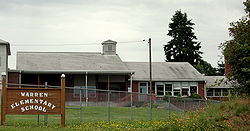 Warren Elementary School | |
 Warren Location within the state of Oregon  Warren Warren (the United States) | |
| Coordinates: 45°48′45″N122°52′00″W / 45.81250°N 122.86667°W | |
| Country | United States |
| State | Oregon |
| County | Columbia |
| Area | |
• Total | 6.33 sq mi (16.40 km2) |
| • Land | 6.31 sq mi (16.35 km2) |
| • Water | 0.02 sq mi (0.05 km2) |
| Elevation | 171 ft (52 m) |
| Population | |
• Total | 1,870 |
| • Density | 296.31/sq mi (114.40/km2) |
| Time zone | UTC-8 (Pacific (PST)) |
| • Summer (DST) | UTC-7 (PDT) |
| ZIP code | 97053 |
| FIPS code | 41-78800 |
| GNIS feature ID | 2611783 [2] |
Warren is an unincorporated community and census-designated place in Columbia County, Oregon, United States, located on U.S. Route 30 north of Scappoose and south of St. Helens on Scappoose Bay of the Multnomah Channel. As of the 2010 census it had a population of 1,787. [4]
Contents
The Warren post office was established in 1885; it was named by local resident James Gill for his hometown of Warren, Massachusetts. [5] The post office was discontinued in 1888, but reestablished in 1890 as "Gilltown" because there was another post office named Warren in Umatilla County. [5] The Columbia County office became Warren again in 1895, and the Umatilla County office was closed in 1902; the locality in Umatilla County is now known as Myrick. [5]