Kerry, Oregon | |
|---|---|
 Kerry  Kerry | |
| Coordinates: 46°07′16″N123°21′07″W / 46.121°N 123.352°W | |
| Country | United States |
| State | Oregon |
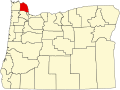
| County | Columbia |
| Elevation | 23 ft (7 m) |
| Time zone | UTC-8 (Pacific (PST)) |
| • Summer (DST) | UTC-7 (PDT) |
| ZIP code | 97016 |
| Area codes | 503 and 971 |
Kerry is an unincorporated community in Columbia County, Oregon, United States, [1] located about 30 miles east of Astoria. It was founded to extend the Columbia & Nehalem River Railroad and named in 1912 by lumberman Albert S. Kerry. In the 1920s it had about 200 inhabitants. [2] [3] Its post office opened in 1917 and closed in 1938. [3]