Marshland, Oregon | |
|---|---|
 An aerial view of Marshland | |
 Marshland  Marshland | |
| Coordinates: 46°06′40″N123°17′10″W / 46.111°N 123.286°W | |
| Country | United States |
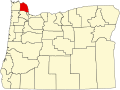
| State | Oregon |
| County | Columbia |
| Elevation | 53 ft (16 m) |
| Time zone | UTC-8 (Pacific (PST)) |
| • Summer (DST) | UTC-7 (PDT) |
Marshland, formerly known as Skunk Cabbage Flat, is an unincorporated community in Columbia County, Oregon, United States. [1] [2] It was settled by Z.B. Bryant in 1862. Its post office was established around 1873. It closed in 1960. [2]