Zigzag is an unincorporated community in Clackamas County, Oregon, United States. It is located within the Mount Hood Corridor, between Rhododendron and Welches on U.S. Route 26. The community is part of a local type of government called a village as one of the communities making up the Villages at Mount Hood, which stretches from the border of Sandy to Government Camp.

The Salmonberry River is a tributary of the Nehalem River, about 20 miles (32 km) long, in northwest Oregon in the United States. It drains a remote unpopulated area of the Northern Oregon Coast Range in the Tillamook State Forest about 65 miles (105 km) west-northwest of Portland. The river runs through part of the region devastated between 1933 and 1951 by a series of wildfires known as the Tillamook Burn.
The Clatskanie River is a tributary of the Columbia River, approximately 25 miles (40 km) long, in northwestern Oregon in the United States. It drains a timber-producing area in the foothills of the Northern Oregon Coast Range north-northwest of Portland.
Mist is an unincorporated community in Columbia County, Oregon, United States. Formerly called Riverside, the place was renamed in 1888 for the atmospheric conditions of the Nehalem Valley. The first land claims in the area had been made circa 1870. The original Riverside post office was closed in 1975.

Oregon Route 47 is an Oregon state highway that runs between the Willamette Valley, near McMinnville, and the city of Clatskanie, along the Columbia River in the northwest part of the state. OR 47 traverses several highways of the Oregon state highway system: part of the Tualatin Valley Highway No. 29, part of the Nehalem Highway No. 102, part of the Sunset Highway No. 47, and the Mist–Clatskanie Highway No. 110.

Svensen is an unincorporated community and census-designated place (CDP) on the Columbia River in Clatsop County, Oregon, United States, named after early settler Peter Svensen. There was a post office in Svensen from 1895 to 1944. Since the closure of the Svensen Post Office, mail service has been provided by rural carriers of the Astoria, Oregon post office. Svensen is within the Knappa School District.

Kinton is an unincorporated community in Washington County, Oregon, United States. It is located near the northern shore of the Tualatin River, near the intersection of Oregon Route 210 and River Road, a major county arterial that runs northwest towards Hillsboro. Kinton is located approximately eight miles north of Newberg, six miles southwest of Beaverton, and seven miles southeast of Hillsboro. The community was once the site of a ferry crossing the Tualatin River between Kinton and nearby Scholls. While the ferry has long since been replaced with a bridge, OR 210 is still known locally as Scholls Ferry Road. Kinton is in Oregon's wine country, with several notable wineries in the area.
Jewell is an unincorporated community in Clatsop County, Oregon, United States. The logging community is located at the junction of Oregon Route 103 and Oregon Route 202, near the Nehalem River.

Apiary is an unincorporated community in Columbia County, Oregon, United States, that takes its name from a post office established by David M. Dorsey. The post office operated from August 28, 1889, until March 24, 1924. It is reported that Dorsey was a beekeeper, which provided the source of the name for the Post Office and thus the community.
Antone is a former community in Wheeler County, in the U.S. state of Oregon. Antone is south of U.S. Route 26 between Mitchell and Dayville.

Manhattan Beach State Recreation Site is a state park in the U.S. state of Oregon. Administered by the Oregon Parks and Recreation Department, the park is open to the public and is fee-free. Amenities at the park, which is 2 miles (3 km) north of Rockaway Beach along U.S. Route 101, include picnicking, fishing, and a Pacific Ocean beach.

Elsie is an unincorporated community in Clatsop County, Oregon, United States. It is located in the Northern Oregon Coast Range, west of the junction of Oregon Route 103 and U.S. Route 26 where the roads cross the Nehalem River.

Olney is an unincorporated community and former company town in Clatsop County, Oregon, United States, on Oregon Route 202 approximately eight miles south of Astoria. Olney is located at 46.100109°N 123.757637°W. Its post office is assigned ZIP code 97325.
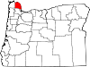
Kerry is an unincorporated community in Columbia County, Oregon, United States, located about 30 miles east of Astoria. It was founded to extend the Columbia & Nehalem River Railroad and named in 1912 by lumberman Albert S. Kerry. In the 1920s it had about 200 inhabitants. Its post office opened in 1917 and closed in 1938.
Mohler is an unincorporated community in Tillamook County, Oregon, United States. It is east of U.S. Route 101 on Oregon Route 53 along the Nehalem River.
Hamlet is an unincorporated community in Clatsop County, Oregon, United States. It is located approximately six miles southeast of Necanicum, in the Northern Oregon Coast Range near the confluence of the North Fork Nehalem River and the Little North Fork Nehalem River. It is surrounded by units of the Clatsop State Forest.
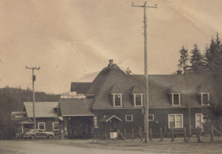
Clarno is an unincorporated community in Wasco County, Oregon, United States. It is located along Oregon Route 218 near the John Day River.

Foss is an unincorporated community in Tillamook County, Oregon, United States. It is about 4 miles (6 km) east of Mohler and Oregon Route 53, near the Nehalem River. Foss is the site of an important river flood gauge.
Vesper is an unincorporated community in Clatsop County, Oregon, United States. The Nehalem River flows through the town. Settled in 1876 by William Johnston, a man who would be responsible for the town's first post office and church, Vesper borders Jewell and the Columbia County line. Johnston also served as the town's first postmaster. Before 1901, Vesper was completely isolated from the rest of the county on land; for one to reach the community, it would have been necessary to travel via ferry on the Nehalem River. The county expanded wagon roads to the community, eventually leading to automobile roads being built in 1908. Nowadays, Oregon Route 202 passes through Vesper.
Blalock was an unincorporated community located in the Columbia River Gorge in Gilliam County, Oregon, United States. The town displaced a Native American settlement originally named Táwash. Blalock was located about 7 miles (11 km) west of Arlington on Interstate 84/U.S. Route 30 at the mouth of Blalock Canyon. Blalock is still the name of a station on the Union Pacific Railroad.