Vernonia, Oregon

Last updated

Vernonia, Oregon
Vernonia, Oregon.jpg
Downtown Vernonia
Vernonia Oregon logo.svg
Columbia County Oregon Incorporated and Unincorporated areas Vernonia Highlighted.svg
Location in Oregon
Coordinates: 45°51′40″N123°11′00″W / 45.86111°N 123.18333°W / 45.86111; -123.18333
Country United States
State Oregon
County Columbia
Incorporated 1891
Government
   Mayor Rick Hobart [1]
Area
[2]
  Total1.69 sq mi (4.38 km2)
  Land1.64 sq mi (4.25 km2)
  Water0.05 sq mi (0.13 km2)
Elevation
[3]
774 ft (236 m)
Population
 (2020) [4]
  Total2,374
  Density1,444.92/sq mi (558.05/km2)
Time zone UTC-8 (Pacific)
  Summer (DST) UTC-7 (Pacific)
ZIP code
97064
Area code(s) 503 and 971
FIPS code 41-77250 [5]
GNIS feature ID2412152 [3]
Website www.vernonia-or.gov

Vernonia is a city in Columbia County, Oregon, United States. It is located on the Nehalem River, in a valley on the eastern side of the Northern Oregon Coast Range that is the heart of one of the most important timber-producing areas of the state. Logging has played a large role in the history of the city. The population was 2,151 at the 2010 census.

Contents

History

The community was first settled in 1874 by the Parker and Van Blaricom families. Cousins Judson Weed and Ozias Cherrington, both of Ohio, arrived in 1876. Sometime afterwards, the question of a name for the community came up, and Cherrington suggested the name of his daughter (Vernona) in Ohio, which was adopted. Due to a clerical error during the incorporation process, an "i" was inserted into the name. Cherrington died in a farming accident in 1894, never having seen his daughter since his departure from Ohio. [6]

Vernonia started to become more than an isolated farming community on July 10, 1924, when the Oregon-American Lumber Company opened a state-of-the-art lumber mill, which was supported by a railroad line connecting Vernonia to the rest of the country. Oregon-American merged with Long-Bell Lumber Company in May 1953, which itself merged with International Paper in November 1957. International Paper judged the mill antiquated, and closed it on December 20, 1957.

The city has been severely impacted by floods on multiple occasions. The rains that caused the Willamette Valley Flood of 1996 flooded Vernonia as well; some homes in the floodplain were elevated, and some flooring materials were replaced, mitigating some damage from later flooding. [7] In 2007, heavy storms that impacted the Pacific Northwest washed out roads and destroyed homes, cars, [7] and communications infrastructure. [8] Despite preparations in 1996, in some parts of town flood water reached 4 feet (1.2 m) above the 100 year base flood elevation. [9] In the wake of the 2007 flood, Vernonia School District voters approved a $13 million bond in 2009 to build a new K-12 school in Vernonia. [10] [11] The new school opened in fall 2012. [12]

Community events

The Friendship Jamboree is an annual event inaugurated in 1957 and currently held on the first full weekend of August. [13]

Geography

According to the United States Census Bureau, the city has a total area of 1.66 square miles (4.30 km2), of which 1.61 square miles (4.17 km2) is land and 0.05 square miles (0.13 km2) is water. [14]

Climate

This region experiences warm (but not hot) and dry summers, with no average monthly temperatures above 71.6 °F (22.0 °C). According to the Köppen Climate Classification system, Vernonia has a warm-summer Mediterranean climate, abbreviated "Csb" on climate maps. [15]

Climate data for Vernonia, Oregon, 19912020 normals, extremes 1967present
MonthJanFebMarAprMayJunJulAugSepOctNovDecYear
Record high °F (°C)66
(19)
72
(22)
79
(26)
89
(32)
99
(37)
111
(44)
104
(40)
103
(39)
103
(39)
93
(34)
73
(23)
64
(18)
111
(44)
Mean maximum °F (°C)55.2
(12.9)
60.7
(15.9)
68.3
(20.2)
76.9
(24.9)
84.7
(29.3)
88.0
(31.1)
93.4
(34.1)
94.1
(34.5)
89.4
(31.9)
77.3
(25.2)
61.7
(16.5)
54.1
(12.3)
97.4
(36.3)
Average high °F (°C)45.7
(7.6)
49.4
(9.7)
53.6
(12.0)
58.6
(14.8)
65.5
(18.6)
69.9
(21.1)
77.3
(25.2)
78.2
(25.7)
73.1
(22.8)
61.4
(16.3)
50.6
(10.3)
44.3
(6.8)
60.6
(15.9)
Daily mean °F (°C)38.7
(3.7)
40.2
(4.6)
43.5
(6.4)
47.1
(8.4)
52.9
(11.6)
57.2
(14.0)
62.3
(16.8)
62.5
(16.9)
58.0
(14.4)
49.8
(9.9)
42.4
(5.8)
37.8
(3.2)
49.4
(9.6)
Average low °F (°C)31.6
(−0.2)
30.9
(−0.6)
33.5
(0.8)
35.6
(2.0)
40.3
(4.6)
44.4
(6.9)
47.2
(8.4)
46.9
(8.3)
42.9
(6.1)
38.3
(3.5)
34.2
(1.2)
31.3
(−0.4)
38.1
(3.4)
Mean minimum °F (°C)18.5
(−7.5)
19.7
(−6.8)
24.1
(−4.4)
27.4
(−2.6)
30.7
(−0.7)
35.3
(1.8)
38.5
(3.6)
37.7
(3.2)
32.9
(0.5)
25.8
(−3.4)
21.6
(−5.8)
18.6
(−7.4)
12.4
(−10.9)
Record low °F (°C)−2
(−19)
−6
(−21)
13
(−11)
22
(−6)
27
(−3)
30
(−1)
33
(1)
32
(0)
23
(−5)
10
(−12)
2
(−17)
−7
(−22)
−7
(−22)
Average precipitation inches (mm)6.94
(176)
5.34
(136)
5.30
(135)
3.74
(95)
2.39
(61)
1.44
(37)
0.39
(9.9)
0.55
(14)
1.79
(45)
4.12
(105)
7.70
(196)
8.33
(212)
48.03
(1,221.9)
Average snowfall inches (cm)0.3
(0.76)
0.6
(1.5)
0.0
(0.0)
0.0
(0.0)
0.0
(0.0)
0.0
(0.0)
0.0
(0.0)
0.0
(0.0)
0.0
(0.0)
0.0
(0.0)
0.0
(0.0)
0.2
(0.51)
1.1
(2.77)
Average precipitation days (≥ 0.01 in)20.016.819.517.412.49.53.73.57.814.819.820.0165.2
Average snowy days (≥ 0.1 in)0.20.20.00.00.00.00.00.00.00.00.00.10.5
Source 1: NOAA [16]
Source 2: National Weather Service [17]

Demographics

Historical population
CensusPop.Note
1900 62
1910 6911.3%
1920 142105.8%
1930 1,6251,044.4%
1940 1,412−13.1%
1950 1,5217.7%
1960 1,089−28.4%
1970 1,64350.9%
1980 1,7858.6%
1990 1,8081.3%
2000 2,22823.2%
2010 2,151−3.5%
2020 2,37410.4%
U.S. Decennial Census [18] [4]

2010 census

As of the census of 2010, there were 2,151 people, 822 households, and 571 families residing in the city. The population density was 1,336.0 inhabitants per square mile (515.8/km2). There were 962 housing units at an average density of 597.5 per square mile (230.7/km2). The racial makeup of the city was 94.1% White, 0.3% African American, 1.3% Native American, 0.5% Asian, 0.2% Pacific Islander, 0.8% from other races, and 2.8% from two or more races. Hispanic or Latino of any race were 4.2% of the population. [5]

There were 822 households, of which 35.5% had children under the age of 18 living with them, 52.6% were married couples living together, 11.1% had a female householder with no husband present, 5.8% had a male householder with no wife present, and 30.5% were non-families. 25.7% of all households were made up of individuals, and 8.9% had someone living alone who was 65 years of age or older. The average household size was 2.61 and the average family size was 3.09. [5]

The median age in the city was 38.2 years. 26.9% of residents were under the age of 18; 7.8% were between the ages of 18 and 24; 25.3% were from 25 to 44; 29.2% were from 45 to 64; and 10.8% were 65 years of age or older. The gender makeup of the city was 51.0% male and 49.0% female. [5]

2000 census

As of the census of 2000, there were 2,228 people, 789 households, and 583 families residing in the city. The population density was 1,444.2 inhabitants per square mile (557.6/km2). There were 880 housing units at an average density of 570.4 per square mile (220.2/km2). The racial makeup of the city was 95.38% White, 0.18% African American, 1.39% Native American, 0.49% Asian, 0.09% Pacific Islander, 0.54% from other races, and 1.93% from two or more races. Hispanic or Latino of any race were 2.24% of the population. 19.6% were of German, 14.7% English, 9.5% American, 8.6% Irish and 5.3% Scottish ancestry according to Census 2000. [5]

There were 789 households, out of which 41.4% had children under the age of 18 living with them, 59.4% were married couples living together, 10.4% had a female householder with no husband present, and 26.0% were non-families. 20.9% of all households were made up of individuals, and 7.4% had someone living alone who was 65 years of age or older. The average household size was 2.82 and the average family size was 3.29. [5]

In the city, the population was spread out, with 34.0% under the age of 18, 6.5% from 18 to 24, 30.8% from 25 to 44, 18.9% from 45 to 64, and 9.8% who were 65 years of age or older. The median age was 32 years. For every 100 females, there were 99.5 males. For every 100 females age 18 and over, there were 99.3 males. [5]

The median income for a household in the city was $41,181, and the median income for a family was $48,563. Males had a median income of $37,447 versus $24,219 for females. The per capita income for the city was $16,647. About 8.6% of families and 9.7% of the population were below the poverty line, including 12.0% of those under age 18 and 6.4% of those age 65 or over. [5]

Transportation

Oregon Route 47 is the only major highway serving Vernonia, providing access from the lower Columbia River and Route 30 to the north, and from Oregon Highway 26 to the south. [19] The Banks–Vernonia State Trail, a rails-to-trails conversion featuring a 21-mile (34 km) raised path for bicyclists, pedestrians, and horseback riders, roughly parallels Route 47 to the south of Vernonia. The Crown Zellerbach trail is a conversion of old logging roads (themselves a conversion from old railroad way) to a trail for mountain biking, hiking, and horseback riding. This trail extends over 20 miles (32 km) Vernonia to Scappoose. [20] In 2023 the trail was designated as a National Recreation Trail to be included in the National Trail System. [21]

Public transit

Very limited public transit service provided by the Columbia County Rider (or CC Rider), a service of the county's Transit Division, connects Vernonia with the Willow Creek MAX light rail station and bus transit center of TriMet in Hillsboro. [22] Called the Nehalem Valley Fixed-Route Service, the bus route was introduced on July 1, 2009, [23] and currently operates on Mondays, Wednesdays, and Fridays, twice per day (as one round trip in each rush hour). [22]

Airport

Vernonia Municipal Airport (FAA: 05S) is a city-owned, public-use airport located two nautical miles (3.7 km) west of the central business district of Vernonia. [24]

The December 2007 flooding in Vernonia was featured in the first season of the television show Ax Men . [25]

Vernonia has also appeared in several films, including Ring of Fire (1961), [26] The Vernonia Incident (1989), [27] Thumbsucker (2005), [28] Tillamook Treasure (2006), [29] The Water Man (2020), [30] and Twilight (2008).

See also

Related Research Articles

<span class="mw-page-title-main">Tillamook County, Oregon</span> County in Oregon, United States

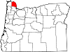
Tillamook County is one of the 36 counties in the U.S. state of Oregon. As of the 2020 census, the population was 27,390. The county seat is Tillamook. The county is named for the Tillamook or Killamook people, a Native American tribe who were living in the area in the early 19th century at the time of European American settlement. The county is located within Northwest Oregon.

<span class="mw-page-title-main">Columbia County, Oregon</span> County in Oregon, United States

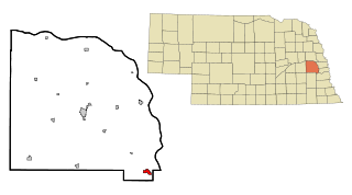
Columbia County is one of the 36 counties in the U.S. state of Oregon. As of the 2020 census, the population was 52,589. The county seat is St. Helens.

<span class="mw-page-title-main">Gibbon, Nebraska</span> City in Nebraska, United States

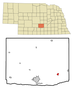
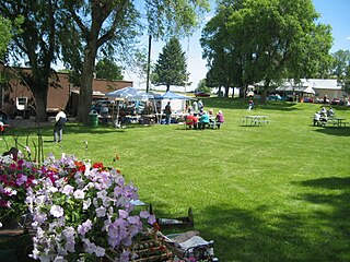
Gibbon is a city in Buffalo County, Nebraska, United States. It is part of the Kearney, Nebraska Micropolitan Statistical Area. The population was 1,833 at the 2010 census.

<span class="mw-page-title-main">Ashland, Nebraska</span> City in Saunders County, Nebraska, United States

Ashland is a city in Saunders County, Nebraska, United States. The population was 3,086 at the 2020 census.

<span class="mw-page-title-main">Huntington, Oregon</span> City in Oregon, United States

Huntington is a city in Baker County, on the eastern border of Oregon, United States. It is located on the Snake River and along Interstate 84 and U.S. Route 30. The population was 440 at the 2010 census, down from 515 in 2000.

<span class="mw-page-title-main">Clatskanie, Oregon</span> City in Oregon, United States

Clatskanie is a city in Columbia County, Oregon, United States. It was named for the Tlatskanai Native American tribe, and the Clatskanie River which flows through the town and empties into the Columbia River about four miles to the north. The population was 1,737 at the 2010 Census.

<span class="mw-page-title-main">Columbia City, Oregon</span> City in Oregon, United States

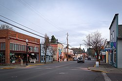
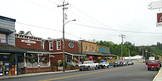
Columbia City is a city in Columbia County, Oregon, United States. It was named for its location on the Columbia River. The population was 1,946 at the 2010 census.

<span class="mw-page-title-main">Sisters, Oregon</span> City in Oregon, United States

Sisters is a city in Deschutes County, Oregon, United States. It is part of the Bend, Oregon Metropolitan Statistical Area. The population was 2,038 at the 2010 census.

<span class="mw-page-title-main">Reedsport, Oregon</span> City in Oregon, United States

Reedsport is a city in northwest Douglas County, Oregon, United States. As of the 2020 census, the population was 4,310.

<span class="mw-page-title-main">Dayville, Oregon</span> City in Oregon, United States

Dayville is a city along U.S. Route 26 in Grant County, in the U.S. state of Oregon. It was incorporated in 1913. The population was 149 at the 2010 census.

<span class="mw-page-title-main">Scio, Oregon</span> City in Oregon, United States

Scio is a city in Linn County, Oregon, United States. The population was 838 at the 2010 census.

<span class="mw-page-title-main">Adrian, Oregon</span> City in Oregon, United States

Adrian is a city in Malheur County, Oregon, United States, near the confluence of the Snake River and the Owyhee River. The population was 177 at the 2010 census. It is part of the Ontario, OR–ID Micropolitan Statistical Area.

<span class="mw-page-title-main">Jefferson, Oregon</span> City in Oregon, United States

Jefferson is a city in Marion County, Oregon, United States. It is part of the Salem Metropolitan Statistical Area. The population was 3,327 at the 2020 census. It is home to the annual Mint Harvest Festival and is the self-proclaimed "Mint Capital of the World" as well as "Frog Jumping Capital of Oregon." The city sits on the right bank of the Santiam River between Salem and Albany along Oregon Route 164 east of Interstate 5.

<span class="mw-page-title-main">Manzanita, Oregon</span> City in Oregon, United States

Manzanita is a coastal city in Tillamook County, Oregon, United States. It is located on U.S. Route 101 about 25 miles (40 km) equidistant from Seaside to the north and Tillamook to the south. The population was 603 at the 2020 census.

<span class="mw-page-title-main">Nehalem, Oregon</span> City in Oregon, United States

Nehalem is a city in Tillamook County, Oregon, United States. Incorporated in 1889, the city lies along the Nehalem River and Nehalem Bay near the Pacific Ocean. It is bisected by U.S. Route 101. The population was 355 at the 2020 census.

<span class="mw-page-title-main">Wheeler, Tillamook County, Oregon</span> City in Oregon, United States

Wheeler is a city in Tillamook County, Oregon, United States. The population was 414 at the 2010 census. It is named after Coleman Wheeler, who opened a sawmill in the town and had a lumber business; Coleman is a great-grandfather of Ted Wheeler, who as of 2023 is mayor of Portland, Oregon.

<span class="mw-page-title-main">Echo, Oregon</span> City in Oregon, United States

Echo is a city in Umatilla County, Oregon, United States. The population was 699 at the 2010 census. It is part of the Pendleton–Hermiston Micropolitan Statistical Area.

<span class="mw-page-title-main">Banks, Oregon</span> City in Oregon, United States

Banks is a city in Washington County, Oregon, United States which is located in the Tualatin Valley. It is the southern anchor to the Banks–Vernonia State Trail, which is a 21-mile (34 km) long linear trail popular with bicyclists, hikers, and equestrians. The population was 1,777 at the 2010 census. The community was named for John and Nancy Banks, who owned a nearby dairy farm. Incorporated in 1921, it is located in the western part of the county where Oregon Route 6 intersects Oregon Route 47.

<span class="mw-page-title-main">Forest Grove, Oregon</span> City in Oregon, United States

Forest Grove is a city in Washington County, Oregon, United States, 25 miles (40 km) west of Portland. Originally a small farm town, it is now primarily a commuter town in the Portland metro area. Settled in the 1840s, the town was platted in 1850, then incorporated in 1872, making it the first city in Washington County. The population was 21,083 at the 2010 census, an increase of 19.1% over the 2000 figure (17,708).

<span class="mw-page-title-main">Shady Cove, Oregon</span> City in Oregon, United States

Shady Cove is a city in Jackson County, Oregon, United States. The population was 2,904 at the 2010 census.

References

  1. "Mayor and City Council - City of Vernonia". vernonia-or.gov. Retrieved December 30, 2019.
  2. "ArcGIS REST Services Directory". United States Census Bureau. Retrieved October 12, 2022.
  3. 1 2 U.S. Geological Survey Geographic Names Information System: Vernonia, Oregon
  4. 1 2 "Census Population API". United States Census Bureau. Retrieved October 12, 2022.
  5. 1 2 3 4 5 6 7 8 "U.S. Census website". United States Census Bureau . Retrieved December 21, 2012.
  6. Lewis A. McArthur, Oregon Geographic names, fifth edition (Portland: Western Imprints, 1982), pp. 760f
  7. 1 2 Vernonia residents: Flooding is worse than 1996 Archived December 6, 2007, at the Wayback Machine , KATU
  8. "Guard Evacuates Flooded Oregon Town". KNX 1070 AM. Associated Press. 2007.[ permanent dead link ]
  9. Teresa Elliot, PE and Alex Tang PE, ed. (2012). Pacific Northwest Storms of December 1-4, 2007. Reston, VA: ASCE, TCLEE. ISBN   9780784412336. Archived from the original on March 16, 2014.
  10. "Voters support measure to build Vernonia school". The Oregonian. November 4, 2009. Retrieved March 8, 2015.
  11. "An entire school district must be rebuilt | Catalyst". www.vernoniaschools.org. Archived from the original on December 28, 2010. Retrieved June 6, 2022.
  12. "Vernonia celebrates opening of state-of-art new K-12 school to replace flood-ravaged buildings". August 22, 2012.
  13. "Event Info". Archived from the original on August 4, 2017. Retrieved March 8, 2015.
  14. "US Gazetteer files 2010". United States Census Bureau. Archived from the original on January 12, 2012. Retrieved December 21, 2012.
  15. "Vernonia, Oregon". Weatherbase. CantyMedia. 2015. Retrieved October 1, 2015.
  16. "U.S. Climate Normals Quick Access – Station: Vernonia #2, OR". National Oceanic and Atmospheric Administration. Retrieved December 30, 2022.
  17. "NOAA Online Weather Data – NWS Portland". National Weather Service. Retrieved December 30, 2022.
  18. "Census of Population and Housing". Census.gov. Retrieved June 4, 2015.
  19. Bilderback, Ken (February 18, 2009). "All roads lead to Vernonia". Archived from the original on April 1, 2009. Retrieved March 13, 2010.
  20. "Crown Zellerbach trail a jewel of a ride".
  21. "2023 national recreation trails - Office of Communications (U.S. National Park Service)". www.nps.gov. Retrieved June 3, 2023.
  22. 1 2 "CC Rider: Nehalem Valley Fixed Route" (PDF). Columbia County Rider. March 31, 2013. Archived from the original (PDF) on August 28, 2013. Retrieved August 18, 2013.
  23. "News and Current Events". Columbia County Rider. July 1, 2009. Archived from the original on July 8, 2011. Retrieved May 30, 2011.
  24. FAA Airport Form 5010 for 05S PDF . Federal Aviation Administration. Effective 8 April 2010.
  25. Townsley, Nancy (October 30, 2009). "'Ax Men' features local loggers: Reality TV - Vernonia loggers appear on new History Channel show". The Forest Grove News-Times . Archived from the original on February 22, 2013. Retrieved November 17, 2012.
  26. Ring of Fire (1961)
  27. The Vernonia Incident (1989) (V)
  28. Thumbsucker (2005)
  29. The Tillamook Treasure (2006)
  30. The Water Man (2020)