Northern Oregon Coast Range

Last updated
Northern Oregon Coast Range
Lewis and Clark River 3641.JPG
The Northern Coast Range, seen from Saddle Mountain in Clatsop County
Highest point
PeakRogers Peak
Elevation 3,706 ft (1,130 m)
Coordinates 45°39′53″N123°32′53″W / 45.66472°N 123.54806°W / 45.66472; -123.54806
Dimensions
Length100 mi (160 km)north–south
Geography
Country United States
State Oregon
Subdivisions Tualatin Mountains
Parent range Oregon Coast Range, Pacific Coast Ranges
Borders on Central Oregon Coast Range
Geology
Orogeny Geologic fault, basalt flows
Age of rock Paleocene and Eocene
Type of rock volcanic and forearc basin

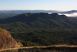
The Northern Oregon Coast Range is the northern section of the Oregon Coast Range, in the Pacific Coast Ranges physiographic region, located in the northwest portion of the state of Oregon, United States. This section of the mountain range, part of the Pacific Coast Ranges, contains peaks as high as 3,710 feet (1,131 m) for Rogers Peak. [1] Forests in these mountains are considered to be some of the most productive timber land in the world. [2] The Central Oregon Coast Range is directly south of this section with the Southern Oregon Coast Range beyond the central range.

Contents

Geology

The origins of these mountains began approximately 40 million years ago during the Eocene age. During this time-period, sandstone and siltstone formed in the area. Additionally, igneous rocks and basalt flows combined with basaltic sandstone to create many of the mountainous formations. Other sedimentary rock in the area formed more recently, around 20 million years ago. It is hypothesized that portions of the northern section of the range were islands during parts of the Eocene era. [3] Other portions of the mountains consist of marine sedimentary rock. [4] The entire coast range sits on a convergent tectonic margin interacting with the Juan de Fuca Plate that is subducting beneath North America tectonic plate. [5] Also, weathering and erosion of the region is a major factor in shaping the landscape. Heavy rainfall and landslides have worked to alter the mountains. [4]

The range is part of a broad, plunging structural arch of sedimentary and Tertiary volcanic strata that is being uplifted. Eocene and Miocene sections form the flanks of the uplifted sections. Some of the oldest rocks are submarine tholeiitic basalts from the Eocene era. The basalt came from the basalt flows that covered much of Oregon and originated from volcanoes in the central portion of the state. Other rocks include sandstone, mudstone, and siltstone. It was during the middle Miocene period that the range was uplifted in the broad, northeast-plunging arch. [6]

Flora and fauna

Logging in the mountains Northern Oregon Coast Range logging.JPG
Logging in the mountains
Fallen logs over the outflow from Soapstone Lake. Soapstone-lake-oregon-coastal-range.jpg
Fallen logs over the outflow from Soapstone Lake.

Portions of the range are in the Siuslaw National Forest and Tillamook State Forest, and large sections of the range were burned in forest fires during the 1930s and 1940s as part of the Tillamook Burn. In the forested areas trees include Sitka spruce, western redcedar, Douglas fir, and western hemlock. [7] Other plants that grow in the region are huckleberry, salmonberry, thimbleberry, salal, vine maple, sword and bracken ferns and Oregon grape to name a few. [7] [8]

Arthropods and molluscs found include collembolans, spiders, beetles, slugs, millipedes, weevils, and various centipedes. [7] [8] Animals that inhabit the Northern Coast range are the rough-skinned newt, chipmunks, bears, rabbits, white-footed deer mice, Columbian black tail deer and others. [8] Birds include chickadees, red-breasted nuthatches, kinglets, Western pileated woodpeckers, Oregon Canada jays, California creepers, and Sitka red crossbills among others. [8]

Location and climate

The range begins at the Columbia River, with some mountainous features on the north side of the river, and continues south roughly 100 miles (160 km) to the Salmon River where Oregon Route 18 traverses the range from the Willamette Valley to the Oregon Coast. The width of the range varies but is roughly 35 miles (56 km). [2]

The climate of the range is moderate because of marine influences, and annual precipitation is heavy, varying from 60 to 180 inches (1,500 to 4,600 mm). [9]

Peaks

Fog covering the mountains near Balm Grove Northern Oregon Coast Range from near Balm Grove.JPG
Fog covering the mountains near Balm Grove
Youngs River, Saddle Mountain and the Northern Oregon Coast Range from the Astoria Column Youngs River from Astoria Column - Oregon.jpg
Youngs River, Saddle Mountain and the Northern Oregon Coast Range from the Astoria Column

All mountains over 3,000 feet (910 m) in elevation in the Northern Coast Range.

Mountain NameElevationCounty
feetmetres
Rogers Peak 3,7061,130Tillamook
South Saddle Mountain 3,4651,056Washington
Larch Mountain 3,4521,052Washington
Trask Mountain 3,4261,044Yamhill
Saddle Mountain 3,2881,002Clatsop
Triangulation Point 3,235986Tillamook
Kings Mountain 3,226983Tillamook
Mount Hebo 3,154961Yamhill
Edwards Butte 3,136956Tillamook
Buck Mountain 3,097944Tillamook
Sheridan Peak 3,091942Yamhill
Woods Point 3,084940Tillamook
Gobblers Knob 3,058932Tillamook
Onion Peak 3,057932Clatsop

Other peaks

Rivers

Map of the region with major rivers in blue. Orange line shows divide between watersheds flowing to the east and those flowing north or west. USGS Oregon Northern Coast Range.png
Map of the region with major rivers in blue. Orange line shows divide between watersheds flowing to the east and those flowing north or west.

The following rivers have their headwaters in the Northern Oregon Coast Range:

Related Research Articles

<span class="mw-page-title-main">Nehalem River</span> River in Oregon, United States

The Nehalem River is a river on the Pacific coast of northwest Oregon in the United States, approximately 119 miles (192 km) long. It drains part of the Northern Oregon Coast Range northwest of Portland, originating on the east side of the mountains and flowing in a loop around the north end of the range near the mouth of the Columbia River. Its watershed of 855 square miles (2,210 km2) includes an important timber-producing region of Oregon that was the site of the Tillamook Burn. In its upper reaches it flows through a long narrow valley of small mountain communities but is unpopulated along most of its lower reaches inland from the coast.

<span class="mw-page-title-main">Salmonberry River</span> River in Oregon, United States

The Salmonberry River is a tributary of the Nehalem River, about 20 miles (32 km) long, in northwest Oregon in the United States. It drains a remote unpopulated area of the Northern Oregon Coast Range in the Tillamook State Forest about 65 miles (105 km) west-northwest of Portland. The river runs through part of the region devastated between 1933 and 1951 by a series of wildfires known as the Tillamook Burn.

<span class="mw-page-title-main">South Saddle Mountain</span>

South Saddle Mountain is the tallest mountain in Washington County, Oregon, United States. Part of the Oregon Coast Range, the peak is located in the Tillamook State Forest in the northwest section of the state of Oregon. It is the eighth-highest peak of the Oregon Coast Range.

Rogers Peak is the highest mountain in Tillamook County, Oregon. Located in the Tillamook State Forest, the peak is also the highest peak in the Northern Oregon Coast Range, which is the northern section of the Oregon Coast Range.

<span class="mw-page-title-main">Central Oregon Coast Range</span> Mountain range in Oregon, United States

The Central Oregon Coast Range is the middle section of the Oregon Coast Range, in the Pacific Coast Ranges physiographic region, and located in the west-central portion of the state of Oregon, United States roughly between the Salmon River and the Umpqua River and the Willamette Valley and the Pacific Ocean. This approximately 90-mile (140 km) long mountain range contains mountains as high as 4,097 feet for Marys Peak. Portions of the range are inside the Siuslaw National Forest and three wilderness areas exist as well: Drift Creek Wilderness, Cummins Creek Wilderness and Rock Creek Wilderness.

Trask Mountain in the Northern Oregon Coast Range, is the tallest mountain in Yamhill County, Oregon. It is located in the northwest corner of the county. Evidently the mountain was named for Elbridge Trask who settled west of the peak in Tillamook County in 1852.

<span class="mw-page-title-main">Oregon Coast Range</span> Mountain range in Oregon, United States

The Oregon Coast Range, often called simply the Coast Range and sometimes the Pacific Coast Range, is a mountain range, in the Pacific Coast Ranges physiographic region, in the U.S. state of Oregon along the Pacific Ocean. This north-south running range extends over 200 miles (320 km) from the Columbia River in the north on the border of Oregon and Washington, south to the middle fork of the Coquille River. It is 30 to 60 miles wide and averages around 1,500 feet (460 m) in elevation above sea level. The coast range has three main sections, a Northern, Central, and Southern.

<span class="mw-page-title-main">Siletz River Volcanics</span> Sequence of basaltic pillow lavas that make up part of Siletzia

The Siletz River Volcanics, located in the Oregon Coast Range, United States, are a sequence of basaltic pillow lavas that make up part of Siletzia. The basaltic pillow lavas originally came from submarine volcanoes that existed during the Eocene.

<span class="mw-page-title-main">Western Cascades</span> Region of Oregon, United States

The Western Cascades or Old Cascades are a sub-province of the Cascade Range in the U.S. state of Oregon, between the Willamette Valley and the High Cascades. The Western Cascades contain many extinct shield volcanoes, cinder cones and lava flows, and the region is highly eroded and heavily forested. Deposits of the same age as the Western Cascades are also found in southwest Washington state.

<span class="mw-page-title-main">Southern Oregon Coast Range</span> Mountain range in Oregon, United States

The Southern Oregon Coast Range is the southernmost section of the Oregon Coast Range, in the Pacific Coast Ranges, located in the southwest portion of the state of Oregon, United States, roughly between the Umpqua River and the middle fork of the Coquille River, beyond which are the Klamath Mountains. To the east is the Umpqua Valley and to the west the Pacific Ocean. This approximately 55-mile (89 km)-long mountain range contains mountains as high as 3,547 feet (1,081 m) for Bone Mountain. The mountains are known locally in the Roseburg area as the Callahan Mountains, or simply as The Callahans.

<span class="mw-page-title-main">Coast Range (EPA ecoregion)</span> Coastal ecoregion in the Western United States

The Coast Range ecoregion is a Level III ecoregion designated by the Environmental Protection Agency (EPA) in the U.S. states of Washington, Oregon, and California. It stretches along the Pacific Coast from the tip of the Olympic Peninsula in the north to the San Francisco Bay in the south, including Grays Harbor, Willapa Bay, and the Long Beach Peninsula in Washington, the entire length of the Oregon Coast, and the Northern California Coast. Named for the Coast Range mountains, it encompasses the lower elevations of the Olympic Mountains, the Oregon Coast Range, the Californian North Coast Ranges, and surrounding lowlands.

<span class="mw-page-title-main">Klamath Mountains (ecoregion)</span> Temperate coniferous forests ecoregion in northern California and southwestern Oregon

The Klamath Mountains ecoregion of Oregon and California lies inland and north of the Coast Range ecoregion, extending from the Umpqua River in the north to the Sacramento Valley in the south. It encompasses the highly dissected ridges, foothills, and valleys of the Klamath and Siskiyou Mountains. It corresponds to the Level III ecoregion designated by the Environmental Protection Agency and to the Klamath-Siskiyou forests ecoregion designated by the World Wide Fund for Nature.

<span class="mw-page-title-main">Coyote Mountains</span> Mountain range in California, United States

The Coyote Mountains are a small mountain range in San Diego and Imperial Counties in southern California. The Coyotes form a narrow ESE trending 2 mi (3.2 km) wide range with a length of about 12 mi (19 km). The southeast end turns and forms a 2 mi (3.2 km) north trending "hook". The highest point is Carrizo Mountain on the northeast end with an elevation of 2,408 feet (734 m). Mine Peak at the northwest end of the range has an elevation of 1,850 ft (560 m). Coyote Wash along I-8 along the southeast margin of the range is 100 to 300 feet in elevation. Plaster City lies in the Yuha Desert about 5.5 mi (8.9 km) east of the east end of the range.

<span class="mw-page-title-main">Caballo Mountains</span>

The Caballo Mountains, are a mountain range located in Sierra and Doña Ana Counties, New Mexico, United States. The range is located east of the Rio Grande and Caballo Lake, and west of the Jornada del Muerto; the south of the range extends into northwest Doña Ana County. The nearest towns are Truth or Consequences and Hatch.

Amethyst Mountain, el. 9,609 feet (2,929 m) is the highest peak and central part of a northwest – southeast trending ridge that lies between the Lamar River to the northeast and Deep Creek to the southwest within Park County, Wyoming. From northwest to southeast, this ridge consists of Specimen Ridge, Amethyst Mountain, and the Mirror Plateau in Yellowstone National Park. The nearest town is Silver Gate, Montana, which is 19.2 miles away.

The Salmonberry Trail is a planned rail trail hiking and biking trail through the Oregon Coast Range along the Salmonberry River in northwest Oregon, United States. A portion of the Port of Tillamook Bay Railroad was washed out by a storm in 2007. In 2012, advocacy efforts to build a trail were launched, and in 2018, the Salmonberry Trail Intergovernmental Agency was established to oversee the development of the trail. The trail is currently closed to the public.

<span class="mw-page-title-main">Geology of Arizona</span> Overview of the geology of Arizona

The geology of Arizona began to form in the Precambrian. Igneous and metamorphic crystalline basement rock may have been much older, but was overwritten during the Yavapai and Mazatzal orogenies in the Proterozoic. The Grenville orogeny to the east caused Arizona to fill with sediments, shedding into a shallow sea. Limestone formed in the sea was metamorphosed by mafic intrusions. The Great Unconformity is a famous gap in the stratigraphic record, as Arizona experienced 900 million years of terrestrial conditions, except in isolated basins. The region oscillated between terrestrial and shallow ocean conditions during the Paleozoic as multi-cellular life became common and three major orogenies to the east shed sediments before North America became part of the supercontinent Pangaea. The breakup of Pangaea was accompanied by the subduction of the Farallon Plate, which drove volcanism during the Nevadan orogeny and the Sevier orogeny in the Mesozoic, which covered much of Arizona in volcanic debris and sediments. The Mid-Tertiary ignimbrite flare-up created smaller mountain ranges with extensive ash and lava in the Cenozoic, followed by the sinking of the Farallon slab in the mantle throughout the past 14 million years, which has created the Basin and Range Province. Arizona has extensive mineralization in veins, due to hydrothermal fluids and is notable for copper-gold porphyry, lead, zinc, rare minerals formed from copper enrichment and evaporites among other resources.

The geology of Georgia is the study of rocks, minerals, water, landforms and geologic history in Georgia. The country is dominated by the Caucasus Mountains at the junction of the Eurasian Plate and the Afro-Arabian Plate, and rock units from the Mesozoic and Cenozoic are particularly prevalent. For much of its geologic history, until the uplift of the Caucasus, Georgia was submerged by marine transgression events. Geologic research for 150 years by Georgian and Russian geologists has shed significant light on the region and since the 1970s has been augmented with the understanding of plate tectonics.

The geology of Yukon includes sections of ancient Precambrian Proterozoic rock from the western edge of the proto-North American continent Laurentia, with several different island arc terranes added through the Paleozoic, Mesozoic and Cenozoic, driving volcanism, pluton formation and sedimentation.

<span class="mw-page-title-main">Geology and geological history of California</span> Description of the geology of California

The geology of California is highly complex, with numerous mountain ranges, substantial faulting and tectonic activity, rich natural resources and a history of both ancient and comparatively recent intense geological activity. The area formed as a series of small island arcs, deep-ocean sediments and mafic oceanic crust accreted to the western edge of North America, producing a series of deep basins and high mountain ranges.

References

  1. Rogers Peak. Peakbagger.com. Retrieved February 29, 2008.
  2. 1 2 Northern Coast Range Adaptive Management Area; Chapter 2: Physical and Biological Environment. Oregon State University. Retrieved February 29, 2008.
  3. Upper Nehalem Watershed Analysis. (PDF) Oregon Department of Forestry. Retrieved February 29, 2008.
  4. 1 2 Byrne, John V. "An Erosional Classification for the Northern Oregon Coast", Annals of the Association of American Geographers, Vol. 54, No. 3. (Sep. 1964), pp. 329–335.
  5. Geology of the Luckiamute River Watershed, Upper Willamette Basin, Polk and Benton Counties, Oregon. (PDF) Western Oregon University. Retrieved February 29, 2008.
  6. Geologic Map of the Tillamook Highlands, Northwest Oregon Coast Range. U.S. Geological Survey. Retrieved February 29, 2008.
  7. 1 2 3 From the Forest to the Sea: A Story of Fallen Trees. Tree Dictionary. Retrieved February 29, 2008.
  8. 1 2 3 4 Macnab, James A. Biotic Aspection in the Coast Range Mountains of Northwestern Oregon. Ecological Monographs, Vol. 28, No. 1. (Jan. 1958), pp. 21–54.
  9. Private Forests. Oregon Department of Forestry. Retrieved February 29, 2008.