
The Klamath Mountains are a rugged and lightly-populated mountain range in northwestern California and southwestern Oregon in the western United States. As a mountain system within both the greater Pacific Coast Ranges and the California Coast Ranges, the Klamath Mountains have a varied geology, with substantial areas of serpentinite and marble, and a climate characterized by moderately cold winters with very heavy snowfall and warm, very dry summers with limited rainfall, especially in the south. As a consequence of the geology and soil types, the mountains harbor several endemic or near-endemic trees, forming one of the largest collections of conifers in the world. The mountains are also home to a diverse array of fish and animal species, including black bears, large cats, owls, eagles, and several species of Pacific salmon. Millions of acres in the mountains are managed by the United States Forest Service. The northernmost and largest sub-range of the Klamath Mountains are the Siskiyou Mountains.

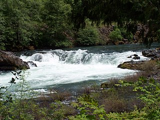
The Rogue River in southwestern Oregon in the United States flows about 215 miles (346 km) in a generally westward direction from the Cascade Range to the Pacific Ocean. Known for its salmon runs, whitewater rafting, and rugged scenery, it was one of the original eight rivers named in the Wild and Scenic Rivers Act of 1968. Beginning near Crater Lake, which occupies the caldera left by the explosive volcanic eruption and collapse of Mount Mazama, the river flows through the geologically young High Cascades and the older Western Cascades, another volcanic province. Further west, the river passes through multiple exotic terranes of the more ancient Klamath Mountains. In the Kalmiopsis Wilderness section of the Rogue basin are some of the world's best examples of rocks that form the Earth's mantle. Near the mouth of the river, the only dinosaur fragments ever discovered in Oregon were found in the Otter Point Formation, along the coast of Curry County.

The Umpqua River on the Pacific coast of Oregon in the United States is approximately 111 miles (179 km) long. One of the principal rivers of the Oregon Coast and known for bass and shad, the river drains an expansive network of valleys in the mountains west of the Cascade Range and south of the Willamette Valley, from which it is separated by the Calapooya Mountains. From its source northeast of Roseburg, the Umpqua flows northwest through the Oregon Coast Range and empties into the Pacific at Winchester Bay. The river and its tributaries flow almost entirely within Douglas County, which encompasses most of the watershed of the river from the Cascades to the coast. The "Hundred Valleys of the Umpqua" form the heart of the timber industry of southern Oregon, generally centered on Roseburg.

The Blue Mountains are a mountain range in the northwestern United States, located largely in northeastern Oregon and stretching into extreme southeastern Washington. The range has an area of about 15,000 square miles (39,000 km2), stretching east and southeast of Pendleton, Oregon, to the Snake River along the Oregon–Idaho border.

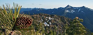
The Siskiyou Mountains are a coastal subrange of the Klamath Mountains, and located in northwestern California and southwestern Oregon in the United States. They extend in an arc for approximately 100 miles (160 km) from east of Crescent City, California, northeast along the north side of the Klamath River into Josephine and Jackson counties in Oregon. The mountain range forms a barrier between the watersheds of the Klamath River to the south and the Rogue River to the north. Accordingly, much of the range is within the Rogue River – Siskiyou and Klamath national forests, and the Pacific Crest Trail follows a portion of the crest of the Siskiyous.
The North Umpqua River is a tributary of the Umpqua River, about 106 miles (171 km) long, in southwestern Oregon in the United States. It drains a scenic and rugged area of the Cascade Range southeast of Eugene, flowing through steep canyons and surrounded by large Douglas-fir forests. Renowned for its emerald green waters, it is considered one of the best fly fishing streams in the Pacific Northwest for anadromous fish.

The South Umpqua River is a tributary of the Umpqua River, approximately 115 miles (185 km) long, in southwestern Oregon in the United States. It drains part of the Cascade Range east of Roseburg. The river passes through a remote canyon in its upper reaches then emerges in the populated South Umpqua Valley east of Canyonville.
The Little River is a tributary of the North Umpqua River, about 30 miles (48 km) long, in southwestern Oregon in the United States. It drains part of the western side of the Cascade Range east of Roseburg, between the North and South Umpqua.

The Calapooya Mountains are a mountain range in Lane and Douglas counties of southwestern Oregon in the United States. The range runs for approximately 60 miles (97 km) west from the Cascade Range between Eugene on the north and Roseburg on the south.

The Central Oregon & Pacific Railroad is a Class II railroad operating between Northern California and Eugene, Oregon, United States. It was previously a mainline owned by the Southern Pacific Railroad (SP) between Eugene and Weed, California via Medford, Oregon. SP sold the route on December 31, 1994, in favor of using its route to Eugene via Klamath Falls, Oregon and Cascade Summit.

Umpqua National Forest, in southern Oregon's Cascade Range, covers an area of 983,129 acres (3,978.58 km2) in Douglas, Lane, and Jackson counties, and borders Crater Lake National Park. The four ranger districts for the forest are the Cottage Grove, Diamond Lake, North Umpqua, and Tiller ranger districts. The forest is managed by the United States Forest Service, headquartered in Roseburg.
The Rogue River–Siskiyou National Forest is a United States National Forest in the U.S. states of Oregon and California. The formerly separate Rogue River and Siskiyou National Forests were administratively combined in 2004. Now, the Rogue River–Siskiyou National Forest ranges from the crest of the Cascade Range west into the Siskiyou Mountains, covering almost 1.8 million acres (7,300 km2). Forest headquarters are located in Medford, Oregon.
The Rogue–Umpqua Divide Wilderness is a wilderness area located in the Rogue River – Siskiyou and Umpqua National Forests in the Klamath Mountains of Oregon, United States. It was established by the United States Congress in 1984 and comprises 33,200 acres (13,400 ha).

The Sky Lakes Wilderness is a wilderness area located in the Rogue River–Siskiyou and Fremont–Winema national forests in the southern Cascade Range of Oregon in the United States. It comprises 116,300 acres (47,100 ha), of which 75,695 acres (30,633 ha) are in the Rogue River–Siskiyou National Forest and 40,605 acres (16,432 ha) are in the Fremont–Winema National Forest. It was established in 1984 under the Wilderness Act of 1964.

The Mount Thielsen Wilderness is a wilderness area located on and around Mount Thielsen in the southern Cascade Range of Oregon in the United States. It is located within the Deschutes, Umpqua, and Fremont–Winema national forests. It was established by the United States Congress in 1984 and comprises 55,100 acres (22,300 ha).

The Central Oregon Coast Range is the middle section of the Oregon Coast Range, in the Pacific Coast Ranges physiographic region, and located in the west-central portion of the state of Oregon, United States roughly between the Salmon River and the Umpqua River and the Willamette Valley and the Pacific Ocean. This approximately 90-mile (140 km) long mountain range contains mountains as high as 4,097 feet for Marys Peak. Portions of the range are inside the Siuslaw National Forest and three wilderness areas exist as well: Drift Creek Wilderness, Cummins Creek Wilderness and Rock Creek Wilderness.

The Oregon Coast Range, often called simply the Coast Range and sometimes the Pacific Coast Range, is a mountain range, in the Pacific Coast Ranges physiographic region, in the U.S. state of Oregon along the Pacific Ocean. This north-south running range extends over 200 miles (320 km) from the Columbia River in the north on the border of Oregon and Washington, south to the middle fork of the Coquille River. It is 30 to 60 miles wide and averages around 1,500 feet (460 m) in elevation above sea level. The coast range has three main sections, a Northern, Central, and Southern.
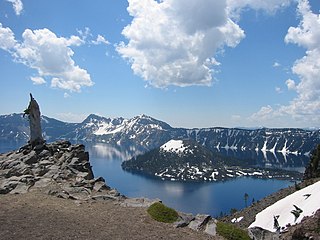
Oregon is 295 miles (475 km) north to south at longest distance, and 395 miles (636 km) east to west. With an area of 98,381 square miles (254,810 km2), Oregon is slightly larger than the United Kingdom. It is the ninth largest state in the United States. Oregon's highest point is the summit of Mount Hood, at 11,249 feet (3,429 m), and its lowest point is the sea level of the Pacific Ocean along the Oregon Coast. Oregon's mean elevation is 3,300 feet (1,006 m). Crater Lake National Park, the state's only national park, is the site of the deepest lake in the United States at 1,943 feet (592 m). Oregon claims the D River as the shortest river in the world, though the state of Montana makes the same claim of its Roe River. Oregon is also home to Mill Ends Park, the smallest park in the world at 452 square inches (0.29 m2).

The Klamath Mountains ecoregion of Oregon and California lies inland and north of the Coast Range ecoregion, extending from the Umpqua River in the north to the Sacramento Valley in the south. It encompasses the highly dissected ridges, foothills, and valleys of the Klamath and Siskiyou Mountains. It corresponds to the Level III ecoregion designated by the Environmental Protection Agency and to the Klamath-Siskiyou forests ecoregion designated by the World Wide Fund for Nature.

Oregon & Northern California Coastal is a freshwater ecoregion in western North America. It includes the coastal rivers of Oregon and Northern California, from the Columbia River mouth in northwestern Oregon to northern Monterey Bay in Central California. It includes the Umpqua, Rogue, Smith River, Klamath, Mad, Eel, and lower Russian rivers, and many smaller coastal rivers and streams, including those on the coast side of the Marin and San Francisco peninsulas.


