Pacific Coast Ranges

Last updated
Pacific Coast Ranges
Canadian Coast Range.jpg
Canadian Coast Range, Whistler, British Columbia
Highest point
Peak Mount Logan
Elevation 5,959 m (19,551 ft)
Dimensions
Length3,800 mi (6,100 km)
Geography
CountriesUnited States, Canada and Mexico
Parent range North American Cordillera
Malibu Canyon, Santa Monica Mountains Santa monica mountains canyon.jpg
Malibu Canyon, Santa Monica Mountains

The Pacific Coast Ranges (officially gazetted as the Pacific Mountain System [1] in the United States) [2] are the series of mountain ranges that stretch along the West Coast of North America from Alaska south to Northern and Central Mexico. Although they are commonly thought to be the westernmost mountain range of the continental United States and Canada, the geologically distinct Insular Mountains of Vancouver Island lie farther west.

Contents

The Pacific Coast Ranges are part of the North American Cordillera (sometimes known as the Western Cordillera, or in Canada, as the Pacific Cordillera and/or the Canadian Cordillera), which includes the Rocky Mountains, the Columbia Mountains, the Interior Mountains, the Interior Plateau, the Sierra Nevada, the Great Basin mountain ranges, and other ranges and various plateaus and basins.

The Pacific Coast Ranges designation, however, only applies to the Western System of the Western Cordillera, [3] which comprises the Saint Elias Mountains, Coast Mountains, Insular Mountains, Olympic Mountains, Cascade Range, Oregon Coast Range, California Coast Ranges, Transverse Ranges, Peninsular Ranges, and the Sierra Madre Occidental.

Other uses

The term Coast Range is used by the United States Geological Survey to refer only to the ranges south of the Strait of Juan de Fuca in Washington to the California-Mexico border, and to those west of Puget Sound, the Willamette Valley, and the Sacramento and San Joaquin valleys (the California Central Valley). That definition excludes the Sierra Nevada and Cascade Ranges, the Mojave (High), and Sonoran (Low) Deserts, [4] i.e. the Pacific Border province. The same term is used informally in Canada to refer to the Coast Mountains and adjoining inland ranges such as the Hazelton Mountains, and sometimes also the Saint Elias Mountains.

Geography

The character of the ranges varies considerably, from the record-setting tidewater glaciers in the ranges of Alaska, to the rugged Central and Southern California ranges, the Transverse Ranges and Peninsular Ranges, in the chaparral and woodlands eco-region with Oak Woodland, Chaparral shrub forest or Coastal sage scrub-covering them. The coastline is often seen dropping steeply into the sea with photogenic views. Along the British Columbia and Alaska coast, the mountains intermix with the sea in a complex maze of fjords, with thousands of islands. Off the Southern California coast the Channel Islands archipelago of the Santa Monica Mountains extends for 160 miles (260 km).

There are coastal plains at the mouths of rivers that have punched through the mountains spreading sediments, most notably at the Copper River in Alaska, the Fraser River in British Columbia, and the Columbia River between Washington and Oregon. In California: the Sacramento and San Joaquin Rivers' San Francisco Bay, the Santa Clara River's Oxnard Plain, the Los Angeles, San Gabriel, and Santa Ana Rivers' Los Angeles Basin  a coastal sediment-filled plain between the peninsular and transverse ranges with sediment in the basin up to 6 miles (10 km) deep, and the San Diego River's Mission Bay.

From the vicinity of San Francisco Bay north, it is common in winter for cool unstable air masses from the Gulf of Alaska to make landfall in one of the Coast Ranges, resulting in heavy precipitation, both as rain and snow, especially on their western slopes. The same Winter weather occurs with less frequency and precipitation in Southern California, with the mountains' western faces and peaks causing an eastward rainshadow that produces the arid desert regions.

Omitted from the list below, but often included is the Sierra Nevada, a major mountain range of eastern California that is separated by the Central Valley over much of its length from the California Coast Ranges and the Transverse Ranges. [5]

Geology

On the West coast of North America, the coast ranges and the coastal plain form the margin. Most of the land is made of terranes that have been accreted onto the margin. In the north, the insular belt is an accreted terrane, forming the margin. This belt extends from the Wrangellia Terrane in Alaska to the Chilliwack group of Canada. [6]

A rupture in Rodinia 750 million years ago formed a passive margin in the eastern Pacific Northwest. The breakup of Pangea 200 million years ago began the westward movement of the North American plate, creating an active margin on the western continent. As the continent drifted West, terranes were accreted onto the west coast. [6] The timing of the accretion of the insular belt is uncertain, although the closure did not occur until at least 115 million years ago. [6] Other Mesozoic terranes that accreted onto the continent include the Klamath Mountains, the Sierra Nevada, and the Guerrero super-terrane of western Mexico. [7] 90–80 million years ago the subducting Farallon plate split and formed the Kula Plate to the North. This formed an area in what is now Northern California, where the plates converged forming a Mélange. North of this was the Columbia Embayment, where the continental margin was east of the surrounding areas. [6] Many of the major batholiths date from the late Cretaceous. [7] As the Laramide Orogeny ended around 48 million years ago, the accretion of the Siletzia terrane began in the Pacific Northwest. This began the volcanic activity in the Cascadia subduction zone, forming the modern Cascade Range, and lasted into the Miocene. Events here may relate to the ignimbrite flare-up of the southern Basin and Range. [8] As extension in the Basin and Range Province slowed by a change in North American Plate movement circa 7 to 8 Million years ago, rifting began on the Gulf of California. [8]

Although many of the ranges do share a common geologic history, the Pacific Coast Ranges province is not defined by geology, but rather by geography. Many of the various ranges are composed of distinct forms of rock from many different periods of geological time from the Precambrian in parts of the Little San Bernardino Mountains to 10,000-year-old rock in the Cascade Range. For one example, the Peninsular Ranges, composed of Mesozoic batholitic rock, are geologically extremely different from the San Bernardino Mountains, composed of a mix of Precambrian metamorphic rock and Cenozoic sedimentary rock. However, both are considered part of the Pacific Coast Ranges due to their proximity and similar economic and social impact on surrounding communities.

Major ranges

These are the members of the Pacific Coast Ranges, from north to south:

Kenai Mountains Turnagain Arm and Kenai Mountains.jpg
Kenai Mountains

Major icefields

These are not named as ranges, but amount to the same thing. The Pacific Coast Ranges are home to the largest temperate-latitude icefields in the world.

Only the largest icefields are listed above; smaller icefields may be listed on the various range pages. Formally unnamed icefields are not listed

See also

Related Research Articles

<span class="mw-page-title-main">Geography of California</span> Overview of the geography of California

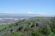
California is a U.S. state on the western coast of North America. Covering an area of 163,696 sq mi (423,970 km2), California is among the most geographically diverse states. The Sierra Nevada, the fertile farmlands of the Central Valley, and the arid Mojave Desert of the south are some of the major geographic features of this U.S. state. It is home to some of the world's most exceptional trees: the tallest, most massive, and oldest. It is also home to both the highest and lowest points in the 48 contiguous states. The state is generally divided into Northern and Southern California, although the boundary between the two is not well defined. San Francisco is decidedly a Northern California city and Los Angeles likewise a Southern California one, but areas in between do not often share their confidence in geographic identity. The US Geological Survey defines the geographic center of the state at a point near North Fork, California.

<span class="mw-page-title-main">Baja California peninsula</span> Peninsula of Mexico on the Pacific Coast of Mexico

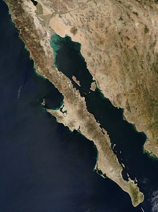
The Baja California peninsula is a peninsula in northwestern Mexico. It separates the Gulf of California from the Pacific Ocean. The peninsula extends from Mexicali, Baja California, in the north to Cabo San Lucas, Baja California Sur, in the south.

<span class="mw-page-title-main">Coast Mountains</span> Mountain range in Canada and the United States

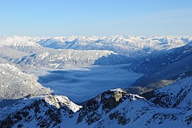
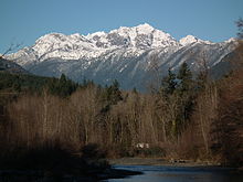
The Coast Mountains are a major mountain range in the Pacific Coast Ranges of western North America, extending from southwestern Yukon through the Alaska Panhandle and virtually all of the Coast of British Columbia south to the Fraser River. The mountain range's name derives from its proximity to the sea coast, and it is often referred to as the Coast Range. The range includes volcanic and non-volcanic mountains and the extensive ice fields of the Pacific and Boundary Ranges, and the northern end of the volcanic system known as the Cascade Volcanoes. The Coast Mountains are part of a larger mountain system called the Pacific Coast Ranges or the Pacific Mountain System, which includes the Cascade Range, the Insular Mountains, the Olympic Mountains, the Oregon Coast Range, the California Coast Ranges, the Saint Elias Mountains and the Chugach Mountains. The Coast Mountains are also part of the American Cordillera—a Spanish term for an extensive chain of mountain ranges—that consists of an almost continuous sequence of mountain ranges that form the western backbone of North America, Central America, South America and Antarctica.

<span class="mw-page-title-main">Peninsular Ranges</span> Group of mountain ranges in Southern California and northern Mexico

The Peninsular Ranges are a group of mountain ranges that stretch 1,500 km (930 mi) from Southern California to the southern tip of the Baja California peninsula; they are part of the North American Coast Ranges, which run along the Pacific Coast from Alaska to Mexico. Elevations range from 150 to 3,300 m.

<span class="mw-page-title-main">American Cordillera</span> Series of mountain ranges in the western Americas

The American Cordillera is a chain of mountain ranges (cordilleras) that consists of an almost continuous sequence of mountain ranges that form the western "backbone" of the Americas. With Aconcagua as the highest peak of the chain. It is also the backbone of the volcanic arc that forms the eastern half of the Pacific Ring of Fire.

The Nevadan orogeny occurred along the western margin of North America during the Middle Jurassic to Early Cretaceous time which is approximately from 155 Ma to 145 Ma. Throughout the duration of this orogeny there were at least two different kinds of orogenic processes occurring. During the early stages of orogenesis an "Andean type" continental magmatic arc developed due to subduction of the Farallon oceanic plate beneath the North American Plate. The latter stages of orogenesis, in contrast, saw multiple oceanic arc terranes accreted onto the western margin of North America in a "Cordilleran type" accretionary orogen. Deformation related to the accretion of these volcanic arc terranes is mostly limited to the western regions of the resulting mountain ranges and is absent from the eastern regions. In addition, the deformation experienced in these mountain ranges is mostly due to the Nevadan orogeny and not other external events such as the more recent Sevier and Laramide Orogenies. It is noted that the Klamath Mountains and the Sierra Nevada share similar stratigraphy indicating that they were both formed by the Nevadan orogeny. In comparison with other orogenic events, it appears that the Nevadan Orogeny occurred rather quickly taking only about 10 million years as compared to hundreds of millions of years for other orogenies around the world.

<span class="mw-page-title-main">Pacific Ranges</span> Subrange of the Coast Mountains in British Columbia, Canada

The Pacific Ranges are the southernmost subdivision of the Coast Mountains portion of the Pacific Cordillera. Located entirely within British Columbia, Canada, they run northwest from the lower stretches of the Fraser River to Bella Coola and Burke Channel, north of which are the Kitimat Ranges. The Coast Mountains lie between the Interior Plateau and the Coast of British Columbia.

<span class="mw-page-title-main">North American Cordillera</span> North American portion of the American Cordillera mountain chain

The North American Cordillera, sometimes also called the Western Cordillera of North America, the Western Cordillera or the Pacific Cordillera, is the North American portion of the American Cordillera, the mountain chain system (cordillera) along the western coast of the Americas. The North American Cordillera covers an extensive area of mountain ranges, intermontane basins and plateaus in Western/Northwestern Canada, Western United States and Mexico, including much of the territory west of the Great Plains.

<span class="mw-page-title-main">California Coast Ranges</span> Mountain range

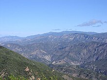
The Coast Ranges of California span 400 miles (644 km) from Del Norte or Humboldt County, California, south to Santa Barbara County. The other three coastal California mountain ranges are the Transverse Ranges, Peninsular Ranges and the Klamath Mountains.

<span class="mw-page-title-main">Ha-Iltzuk Icefield</span>

The Ha-Iltzuk Icefield is an icefield in the central Pacific Ranges of the Coast Mountains in British Columbia, Canada. It is the largest icefield in the Coast Mountains south of the Alaska Panhandle, with an area of 3,610 km2 (1,390 sq mi). It is located on the west side of the Klinaklini River and the Waddington Range. The highest summit in the icefield is Mount Silverthrone, which is a mountain on the northeast edge of a circular, 20 km (12 mi) wide, deeply dissected caldera complex called the Silverthrone Caldera.

<span class="mw-page-title-main">Geology of the Pacific Northwest</span> Geology of Oregon and Washington (United States) and British Columbia (Canada)

The geology of the Pacific Northwest includes the composition, structure, physical properties and the processes that shape the Pacific Northwest region of North America. The region is part of the Ring of Fire: the subduction of the Pacific and Farallon Plates under the North American Plate is responsible for many of the area's scenic features as well as some of its hazards, such as volcanoes, earthquakes, and landslides.

<span class="mw-page-title-main">Wrangellia Terrane</span> Geological area in northwestern North America

The Wrangellia Terrane is a crustal fragment (terrane) extending from the south-central part of Alaska and along the Coast of British Columbia in Canada. Some geologists contend that Wrangellia extends southward to Oregon, although this is not generally accepted.

<span class="mw-page-title-main">Geology of British Columbia</span>

The geology of British Columbia is a function of its location on the leading edge of the North American continent. The mountainous physiography and the diversity of the different types and ages of rock hint at the complex geology, which is still undergoing revision despite a century of exploration and mapping.

This is a list of articles related to plate tectonics and tectonic plates.

<i>Salix bonplandiana</i> Species of willow

Salix bonplandiana, , is a perennial species of willow tree native to southern and southwest Mexico and extending into central Guatemala; in western Mexico it is a tree of the Sierra Madre Occidental cordillera, but also occurring in other small locales, for example Baja California Sur, northern Sonora, San Luis Potosi, etc. A core disjunct area occurs in central and southeast Arizona, in advantageous locales, especially associated with higher elevations and water.

<span class="mw-page-title-main">Geology of North America</span> Overview of the geology of North America

The geology of North America is a subject of regional geology and covers the North American continent, the third-largest in the world. Geologic units and processes are investigated on a large scale to reach a synthesized picture of the geological development of the continent.

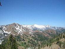
The geology of California is highly complex, with numerous mountain ranges, substantial faulting and tectonic activity, rich natural resources and a history of both ancient and comparatively recent intense geological activity. The area formed as a series of small island arcs, deep-ocean sediments and mafic oceanic crust accreted to the western edge of North America, producing a series of deep basins and high mountain ranges.

Southern California Coastal–Baja California is a freshwater ecoregion in Western North America. It covers portions of central and southern California and west of the Coast Ranges as well as most of Mexico's Baja California Peninsula, extending from the southern end of Monterey Bay to the southern tip of the Baja California Peninsula.

References

  1. Physiographic regions of the United States, USGS
  2. Merriam-Webster's collegiate encyclopedia , page 361 (Merriam-Webster, 2000).
  3. S. Holland, Landforms of British Columbia , BC Govt. 1976.
  4. "Coast Ranges". Geographic Names Information System . United States Geological Survey, United States Department of the Interior . Retrieved 30 July 2007.
  5. "Pacific mountain system". Britannica Online Encyclopedia. Encyclopædia Britannica. Retrieved 2007-09-29.
  6. 1 2 3 4 Townsend, Catherine; Figge, John (2002). "Northwest Origins". The Burke Museum.
  7. 1 2 Dickinson, William (2004). "Evolution of the North American Cordillera" (PDF). Annual Review of Earth and Planetary Sciences. 32: 13–45. doi:10.1146/annurev.earth.32.101802.120257. Archived from the original (PDF) on 4 January 2014. Retrieved 9 April 2013.
  8. 1 2 Humphreys, Eugene (2009-06-01). "Relation of flat subduction to magmatism and deformation in the Western United States". Backbone of the Americas: Shallow Subduction, Plateau Uplift, and Ridge and Terrane Collision. Geological Society of America. doi:10.1130/978-0-8137-2446-1-204.0.v. ISBN   9780813712048.