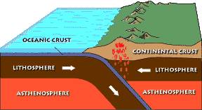
Aleutian Arc

Last updated
Map showing the volcanoes and islands of the Aleutian Arc. Map of alaska volcanoes cleveland.jpg
Map showing the volcanoes and islands of the Aleutian Arc.

The Aleutian Arc is a large volcanic arc of islands extending from the Southwest tip of the U.S. state of Alaska to the Kamchatka Peninsula of the Russian Federation.

Contents

It consists of a number of active and dormant volcanoes that have formed as a result of the subduction of the Pacific Plate beneath the North American Plate along the Aleutian Trench. Although taking its name from the Aleutian Islands, this term is a geologic grouping rather than a geographic one. The Aleutian Arc extends through the Alaska Peninsula following the Aleutian Range through the Aleutian Islands. [1] The arc makes up a sizable portion of the Pacific Ring of Fire, and is known for generating many strong magnitude earthquakes (magnitude 6-6.7) as well as its volcanism. [2]

Formation and geologic features

Formation

The Aleutian Arc reflects subduction of the Pacific Plate beneath the North American Plate. It extends 3,000 km (1,900 mi) from the Kamchatka Peninsula in the west to the Gulf of Alaska in the east. The arc was formed around 55 million years ago during the early Eocene period. [3] [2] Unimak Pass at the southwestern end of the Alaska Peninsula (~165°W) marks the eastward transition from an intra-oceanic in the west to a continental arc in the east. [2] Volcanic activity on the Aleutian Ridge extends from the Southwest corner of Alaska to around 175°E, west of Attu Island (~173°E). [2] The Aleutian Arc is distinct in that its arc massif is laterally extended and intact, which is unusual for an intra-oceanic arc. [3]

Diagram showing the process of subduction and the formation of volcanic arcs. Subduction magma rising.jpg
Diagram showing the process of subduction and the formation of volcanic arcs.

Geologic features

The Aleutian Trench, formed by the subduction of the Pacific Plate under the North American Plate, sits south of the island arc. [2] A forearc basin reaching depths of 7km occupies the space between the trench and the island arc and leads up to the Aleutian Ridge, the north side of which being the area where the most volcanic activity occurs. [2] The Aleutian Ridge is largest near tip of the Alaskan Peninsula (160-225 km wide, 25-35 km thick) and decreases in width (80 km wide near the Komandorski Islands) as it extends west towards the Kamchatka Peninsula. [3] Due to the arcuate geometry of the trench, the relative velocity vector changes from almost trench-normal in the Gulf of Alaska to almost trench-parallel in the west. Along the oceanic part of the subduction zone, convergence varies from 6.3 cm (2.5 in) per year to the north-northwest in the east to 7.4 cm (2.9 in) per year towards the northwest in the west. [4] The eastern Aleutians see an orthogonal direction of convergence relative to the trench, while the more central area sees an oblique direction of convergence relative to the trench. [2] Past Attu Island, the direction of convergence becomes parallel with the trench. [2]

Seismic activity

Image showing the Aleutian Island Arc, along with the trench. The trench is denoted by the dark blue line to the south running parallel with the island arc. The area between the trench and the ridge delineates the blocks of crust that cause much of the seismic activity in the region. Island arc of Aleutian trench.jpg
Image showing the Aleutian Island Arc, along with the trench. The trench is denoted by the dark blue line to the south running parallel with the island arc. The area between the trench and the ridge delineates the blocks of crust that cause much of the seismic activity in the region.

Tectonic activity

The Pacific Plate is continuously converging and moving against the North American Plate at a rate of 48 mm/year eastward and 78 mm/year westward. [2] The oblique direction of convergence in the western and central portions of the area is causing westward transportation of the arc. [3] [2] This movement of the Pacific Plate relative to the North American Plate in the central and west Aleutian Arc also causes portions of the forearc to break off and form rotating crustal blocks between the trench and the island arc. [3] [2] The boundaries of the 5 major blocks that have been identified form areas with cohesive movement that are often disrupted by strike-slip and normal faults. [2] Submarine canyons are present at the boundaries between the blocks due to the clockwise rotation of each block cutting into the surface of the other crustal blocks. [3]

Earthquakes

Thousands of earthquakes per year are seen in this region due to the constant tectonic activity, making the Aleutian islands the most seismically active area in the United States of America. Faulting within the subduction zone (Aleutian Megathrust) as well as within the subducting and overriding plates themselves accounts for the majority of earthquakes that occur. [2] Some smaller magnitude earthquakes are also caused by the volcanic activity of the Aleutian Arc. The regionality of the earthquakes makes it possible for inter-plate and intra-plate events to be differentiated. [2] The majority of events have been noted as having a thrusting mechanism, which denotes them as earthquakes occurring from the interface of a plate. [2] Strike-slip and normal faulting does occur in shallow events, where the depth of the event is less than 30 km deep. [2] Events with a normal fault mechanism tend to occur where the Pacific Plate bends as it forms the Aleutian Trench, whereas strike-slip mechanisms are concentrated inland along the axis of the islands themselves. [2]

The constant activity near the Aleutian Arc has resulted in an area prone to high magnitude earthquakes. One Major earthquake (Mw ≥ 8) occurs every 13 years on average, and strong magnitude earthquakes (Mw 6–7) occur an average of six times per year. [5] The rapid conversion and the gentle subduction angle of the Pacific Plate under the North American Plate also caused a back-arc region of tectonic deformation that spans 700 km from the Aleutian Arc into the interior of Alaska to form. [5] These conditions have allowed for a multitude of major earthquakes to be measured throughout Alaska's history. Most major earthquakes measured in the region tend to be caused by ruptures in the gentle subduction interface between the subducting and overriding plates. [5]

Volcanic activity

Volcanoes within this arc include:

Related Research Articles

<span class="mw-page-title-main">Subduction</span> A geological process at convergent tectonic plate boundaries where one plate moves under the other

Subduction is a geological process in which the oceanic lithosphere and some continental lithosphere is recycled into the Earth's mantle at convergent boundaries. Where the oceanic lithosphere of a tectonic plate converges with the less dense lithosphere of a second plate, the heavier plate dives beneath the second plate and sinks into the mantle. A region where this process occurs is known as a subduction zone, and its surface expression is known as an arc-trench complex. The process of subduction has created most of the Earth's continental crust. Rates of subduction are typically measured in centimeters per year, with rates of convergence as high as 11 cm/year.

<span class="mw-page-title-main">Ring of Fire</span> Region around the rim of the Pacific Ocean where many volcanic eruptions and earthquakes occur

The Ring of Fire is a tectonic belt of volcanoes and earthquakes.

<span class="mw-page-title-main">Aleutian Range</span> Mountain range in the state of Alaska

The Aleutian Range is a major mountain range located in southwest Alaska. It extends from Chakachamna Lake to Unimak Island, which is at the tip of the Alaska Peninsula. It includes all of the mountains of the Peninsula. The Aleutian Range is special because of its large number of active volcanoes, which are also part of the larger Aleutian Arc. The mainland part of the range is about 600 miles (1000 km) long. The Aleutian Islands are (geologically) a partially submerged western extension of the range that stretches for another 1,600 km (1000 mi). However the official designation "Aleutian Range" includes only the mainland peaks and the peaks on Unimak Island. The range is almost entirely roadless wilderness. Katmai National Park and Preserve, a large national park within the range, must be reached by boat or plane.

<span class="mw-page-title-main">Convergent boundary</span> Region of active deformation between colliding tectonic plates

A convergent boundary is an area on Earth where two or more lithospheric plates collide. One plate eventually slides beneath the other, a process known as subduction. The subduction zone can be defined by a plane where many earthquakes occur, called the Wadati–Benioff zone. These collisions happen on scales of millions to tens of millions of years and can lead to volcanism, earthquakes, orogenesis, destruction of lithosphere, and deformation. Convergent boundaries occur between oceanic-oceanic lithosphere, oceanic-continental lithosphere, and continental-continental lithosphere. The geologic features related to convergent boundaries vary depending on crust types.

<span class="mw-page-title-main">Cascadia subduction zone</span> Convergent plate boundary that stretches from northern Vancouver Island to Northern California

The Cascadia subduction zone is a 960 km (600 mi) fault at a convergent plate boundary, about 110–160 km (70–100 mi) off the Pacific coast, that stretches from northern Vancouver Island in Canada to Northern California in the United States. It is capable of producing 9.0+ magnitude earthquakes and tsunamis that could reach 30 m (98 ft). The Oregon Department of Emergency Management estimates shaking would last 5–7 minutes along the coast, with strength and intensity decreasing further from the epicenter. It is a very long, sloping subduction zone where the Explorer, Juan de Fuca, and Gorda plates move to the east and slide below the much larger mostly continental North American Plate. The zone varies in width and lies offshore beginning near Cape Mendocino, Northern California, passing through Oregon and Washington, and terminating at about Vancouver Island in British Columbia.

<span class="mw-page-title-main">Volcanic arc</span> Chain of volcanoes formed above a subducting plate

A volcanic arc is a belt of volcanoes formed above a subducting oceanic tectonic plate, with the belt arranged in an arc shape as seen from above. Volcanic arcs typically parallel an oceanic trench, with the arc located further from the subducting plate than the trench. The oceanic plate is saturated with water, mostly in the form of hydrous minerals such as micas, amphiboles, and serpentines. As the oceanic plate is subducted, it is subjected to increasing pressure and temperature with increasing depth. The heat and pressure break down the hydrous minerals in the plate, releasing water into the overlying mantle. Volatiles such as water drastically lower the melting point of the mantle, causing some of the mantle to melt and form magma at depth under the overriding plate. The magma ascends to form an arc of volcanoes parallel to the subduction zone.

Megathrust earthquakes occur at convergent plate boundaries, where one tectonic plate is forced underneath another. The earthquakes are caused by slip along the thrust fault that forms the contact between the two plates. These interplate earthquakes are the planet's most powerful, with moment magnitudes (Mw) that can exceed 9.0. Since 1900, all earthquakes of magnitude 9.0 or greater have been megathrust earthquakes.

<span class="mw-page-title-main">Aleutian Trench</span> An oceanic trench along the southern coastline of Alaska and the Aleutian islands

The Aleutian Trench is an oceanic trench along a convergent plate boundary which runs along the southern coastline of Alaska and the Aleutian islands. The trench extends for 3,400 kilometres (2,100 mi) from a triple junction in the west with the Ulakhan Fault and the northern end of the Kuril–Kamchatka Trench, to a junction with the northern end of the Queen Charlotte Fault system in the east. It is classified as a "marginal trench" in the east as it runs along the margin of the continent. The subduction along the trench gives rise to the Aleutian Arc, a volcanic island arc, where it runs through the open sea west of the Alaska Peninsula. As a convergent plate boundary, the trench forms part of the boundary between two tectonic plates. Here, the Pacific Plate is being subducted under the North American Plate at a dip angle of nearly 45°. The rate of closure is 7.5 centimetres (3 in) per year.

<span class="mw-page-title-main">Northern Cordilleran Volcanic Province</span> Geologic province in the Pacific Northwest of North America

The Northern Cordilleran Volcanic Province (NCVP), formerly known as the Stikine Volcanic Belt, is a geologic province defined by the occurrence of Miocene to Holocene volcanoes in the Pacific Northwest of North America. This belt of volcanoes extends roughly north-northwest from northwestern British Columbia and the Alaska Panhandle through Yukon to the Southeast Fairbanks Census Area of far eastern Alaska, in a corridor hundreds of kilometres wide. It is the most recently defined volcanic province in the Western Cordillera. It has formed due to extensional cracking of the North American continent—similar to other on-land extensional volcanic zones, including the Basin and Range Province and the East African Rift. Although taking its name from the Western Cordillera, this term is a geologic grouping rather than a geographic one. The southmost part of the NCVP has more, and larger, volcanoes than does the rest of the NCVP; further north it is less clearly delineated, describing a large arch that sways westward through central Yukon.

<span class="mw-page-title-main">Geology of the Pacific Northwest</span> Geology of Oregon and Washington (United States) and British Columbia (Canada)

The geology of the Pacific Northwest includes the composition, structure, physical properties and the processes that shape the Pacific Northwest region of North America. The region is part of the Ring of Fire: the subduction of the Pacific and Farallon Plates under the North American Plate is responsible for many of the area's scenic features as well as some of its hazards, such as volcanoes, earthquakes, and landslides.

<span class="mw-page-title-main">Izu–Bonin–Mariana Arc</span> Convergent boundary in Micronesia

The Izu–Bonin–Mariana (IBM) arc system is a tectonic plate convergent boundary in Micronesia. The IBM arc system extends over 2800 km south from Tokyo, Japan, to beyond Guam, and includes the Izu Islands, the Bonin Islands, and the Mariana Islands; much more of the IBM arc system is submerged below sealevel. The IBM arc system lies along the eastern margin of the Philippine Sea Plate in the Western Pacific Ocean. It is the site of the deepest gash in Earth's solid surface, the Challenger Deep in the Mariana Trench.

<span class="mw-page-title-main">Philippine Mobile Belt</span> Tectonic boundary

In the geology of the Philippines, the Philippine Mobile Belt is a complex portion of the tectonic boundary between the Eurasian Plate and the Philippine Sea Plate, comprising most of the country of the Philippines. It includes two subduction zones, the Manila Trench to the west and the Philippine Trench to the east, as well as the Philippine Fault System. Within the Belt, a number of crustal blocks or microplates which have been shorn off the adjoining major plates are undergoing massive deformation.

<span class="mw-page-title-main">Geology of the Pacific Ocean</span> Overview about the geology of the Pacific Ocean

The Pacific Ocean evolved in the Mesozoic from the Panthalassic Ocean, which had formed when Rodinia rifted apart around 750 Ma. The first ocean floor which is part of the current Pacific Plate began 160 Ma to the west of the central Pacific and subsequently developed into the largest oceanic plate on Earth.

A continental arc is a type of volcanic arc occurring as an "arc-shape" topographic high region along a continental margin. The continental arc is formed at an active continental margin where two tectonic plates meet, and where one plate has continental crust and the other oceanic crust along the line of plate convergence, and a subduction zone develops. The magmatism and petrogenesis of continental crust are complicated: in essence, continental arcs reflect a mixture of oceanic crust materials, mantle wedge and continental crust materials.

<span class="mw-page-title-main">Cook Inlet Basin</span>

The Cook Inlet Basin is a northeast-trending collisional forearc basin that stretches from the Gulf of Alaska into South central Alaska, just east of the Matanuska Valley. It is located in the arc-trench gap between the Alaska-Aleutian Range batholith and contains roughly 80,000 cubic miles of sedimentary rocks. These sediments are mainly derived from Triassic, Jurassic and Cretaceous sediments.

<span class="mw-page-title-main">Aleutian subduction zone</span> Convergence boundary between the North American Plate and the Pacific Plate

The Aleutian subduction zone is a 2,500 mi (4,000 km) long convergent boundary between the North American Plate and the Pacific Plate, that extends from the Alaska Range to the Kamchatka Peninsula. Here, the Pacific Plate is being subducted underneath the North American Plate and the rate of subduction changes from west to east from 7.5 to 5.1 cm per year. The Aleutian subduction zone includes two prominent features, the Aleutian Arc and the Aleutian Trench. The Aleutian Arc was created via volcanic eruptions from dehydration of the subducting slab at ~100 km depth. The Aleutian Trench is a narrow and deep morphology that occurs between the two converging plates as the subducting slab dives beneath the overriding plate.

On July 17 2017, an earthquake struck near the Komandorski Islands, east of the Kamchatka Peninsula in the Bering Sea at. Although there were no casualties from this earthquake, it was notable for a rare characteristic known as supershear, and is one of the few times a large supershear earthquake has been observed. It was preceded by a few foreshocks months earlier, and aftershocks that continued for nearly six months.

<span class="mw-page-title-main">2021 Chignik earthquake</span> 7th largest earthquake in the US

An earthquake occurred off the coast of the Alaska Peninsula on July 28, 2021, at 10:15 p.m. local time. The large megathrust earthquake had a moment magnitude of 8.2 according to the United States Geological Survey (USGS). A tsunami warning was issued by the National Oceanic and Atmospheric Administration (NOAA) but later cancelled. The mainshock was followed by a number of aftershocks, including three that were of magnitude 5.9, 6.1 and 6.9 respectively.

<span class="mw-page-title-main">Oblique subduction</span> Tectonic process

Oblique subduction is a form of subduction for which the convergence direction differs from 90° to the plate boundary. Most convergent boundaries involve oblique subduction, particularly in the Ring of Fire including the Ryukyu, Aleutian, Central America and Chile subduction zones. In general, the obliquity angle is between 15° and 30°. Subduction zones with high obliquity angles include Sunda trench and Ryukyu arc.

The New Britain subduction zone is one of the most recently formed and most active subduction zones on earth, producing great earthquakes, with potential for tsunami hazard, and being associated with active volcanism, as part of the Pacific Ring of Fire. It has a close relationship to an area of subduction tectonic activity that extends south eastward from New Britain to the Vanuatu subduction zone, involving the north eastern portion of the Australian Plate and its complicated collision dynamics with the south-western portion of the Pacific Plate.

References

  1. "A Policy for Rapid Mobilization of USGS OBS (RMOBS) - Alaska Volcanoes". Woods Hole Coastal and Marine Science Center. Archived from the original on 2018-09-23. Retrieved 18 November 2018.
  2. 1 2 3 4 5 6 7 8 9 10 11 12 13 14 15 16 17 Ruppert, Natalia A.; Kozyreva, Natalia P.; Hansen, Roger A. (2012-02-05). "Review of crustal seismicity in the Aleutian Arc and implications for arc deformation". Tectonophysics. 522–523: 150–157. doi:10.1016/j.tecto.2011.11.024. ISSN   0040-1951.
  3. 1 2 3 4 5 6 "Revised age of Aleutian Island Arc formation implies high rate of magma production". pubs.geoscienceworld.org. Retrieved 2023-11-02.
  4. DeMets, Charles; Dixon, Timothy (July 1, 1999). "New kinematic models for Pacific-North America motion from 3 Ma to present, 1: Evidence for steady motion and biases in the NUVEL-1A model" (PDF). Geophysical Research Letters. 26 (13): 1921–1924. doi: 10.1029/1999gl900405 . Retrieved 18 November 2018.
  5. 1 2 3 Tibaldi, A.; Bonali, F. L. (2017-04-01). "Intra-arc and back-arc volcano-tectonics: Magma pathways at Holocene Alaska-Aleutian volcanoes". Earth-Science Reviews. 167: 1–26. doi:10.1016/j.earscirev.2017.02.004. ISSN   0012-8252.

52°17′N174°09′W / 52.28°N 174.15°W / 52.28; -174.15