Kitimat Ranges

Last updated
Kitimat Ranges
French: Chaînons Kitimat
Lax Kw'alaams.jpg
Lax Kw'alaams backdropped by Mount McNeil
Highest point
Peak Howson Peak
Elevation 2,759 m (9,052 ft) [1]
Coordinates 53°50′N128°30′W / 53.833°N 128.500°W / 53.833; -128.500
Dimensions
Area62,777 km2 (24,238 sq mi)
Geography
BC-relief Kitimatranges.png
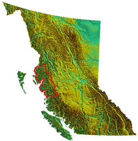
Kitimat Ranges as defined in S. Holland Landforms of British Columbia
Location British Columbia, Canada
Range coordinates 53°49′59″N128°30′05″W / 53.83306°N 128.50139°W / 53.83306; -128.50139 [2]
Parent range Coast Mountains

The Kitimat Ranges are one of the three main subdivisions of the Coast Mountains in British Columbia, Canada, the others being the Pacific Ranges to the south and the Boundary Ranges to the north.

Contents

Geography

The Kitimat Ranges, rising behind Kitimat, British Columbia Kitimat BC - aerial.jpg
The Kitimat Ranges, rising behind Kitimat, British Columbia

The Kitimat Ranges lie between the Nass River and Portland Inlet in the north [2] and the Bella Coola River and Burke Channel on the south, and are bounded on their east by the Hazelton Mountains and include the mountainous islands of the North Coastal Archipelago, as well as King Island, which lies between Dean Channel and the aforesaid Burke Channel. Some of those islands are part of a separate formation known as the Coastal Trough. [3] [4]

Although lower than the neighbouring Pacific Ranges to the south, they are in some ways more rugged, and are heavily indented by coastal inlets as well as by fjord-like lake valleys on the Interior side of the range.

Sub-ranges

Parks

Rivers

Rivers within or originating in, or which transit the Kitimat Ranges, are:

See also

Related Research Articles

<span class="mw-page-title-main">Coast Mountains</span> Mountain range in Canada and the United States

The Coast Mountains are a major mountain range in the Pacific Coast Ranges of western North America, extending from southwestern Yukon through the Alaska Panhandle and virtually all of the Coast of British Columbia south to the Fraser River. The mountain range's name derives from its proximity to the sea coast, and it is often referred to as the Coast Range. The range includes volcanic and non-volcanic mountains and the extensive ice fields of the Pacific and Boundary Ranges, and the northern end of the volcanic system known as the Cascade Volcanoes. The Coast Mountains are part of a larger mountain system called the Pacific Coast Ranges or the Pacific Mountain System, which includes the Cascade Range, the Insular Mountains, the Olympic Mountains, the Oregon Coast Range, the California Coast Ranges, the Saint Elias Mountains and the Chugach Mountains. The Coast Mountains are also part of the American Cordillera—a Spanish term for an extensive chain of mountain ranges—that consists of an almost continuous sequence of mountain ranges that form the western backbone of North America, Central America, South America and Antarctica.

<span class="mw-page-title-main">Pacific Coast Ranges</span> Series of mountain ranges along the Pacific coast of North America

The Pacific Coast Ranges are the series of mountain ranges that stretch along the West Coast of North America from Alaska south to Northern and Central Mexico. Although they are commonly thought to be the westernmost mountain range of the continental United States and Canada, the geologically distinct Insular Mountains of Vancouver Island lie farther west.

<span class="mw-page-title-main">Pacific Ranges</span> Subrange of the Coast Mountains in British Columbia, Canada

The Pacific Ranges are the southernmost subdivision of the Coast Mountains portion of the Pacific Cordillera. Located entirely within British Columbia, Canada, they run northwest from the lower stretches of the Fraser River to Bella Coola and Burke Channel, north of which are the Kitimat Ranges. The Coast Mountains lie between the Interior Plateau and the Coast of British Columbia.

<span class="mw-page-title-main">Rainbow Range (Chilcotin Plateau)</span> Mountain range in British Columbia, Canada

The Rainbow Range, formerly gazetted as the Rainbow Mountains, is a mountain range in British Columbia, Canada, located 40 kilometres (25 mi) northwest of Anahim Lake. Located on the western edge of the Chilcotin Plateau, the range adjoins the Coast Mountains Pacific Ranges to the south, and the Kitimat Ranges to the north. In some classification systems it is considered part of the Coast Mountains. It lies north of the Bella Coola and Atnarko Rivers and south and west of the Dean River, which curves around its north flank, and is relatively drier in climate and easier of terrain than more mountainous areas immediately west.

<span class="mw-page-title-main">Monarch Mountain</span>

Monarch Mountain is one of the principal summits of the Pacific Ranges subdivision of the Coast Mountains in southern British Columbia. It stands just east of a pass between the Klinaklini River and the south branch of the Atnarko River, which is a tributary of the Bella Coola River. Surrounding Monarch Mountain is the Monarch Icefield, the northernmost of the major icefields of the Pacific Ranges, and just south of it is the Ha-Iltzuk Icefield, which is the largest. Monarch is in the southern end of Tweedsmuir South Provincial Park.

<span class="mw-page-title-main">British Columbia Coast</span> Coastal region of British Columbia, Canada

The British Columbia Coast, popularly referred to as the BC Coast or simply the Coast, is a geographic region of the Canadian province of British Columbia. As the entire western continental coastline of Canada along the Pacific Ocean is in the province, it is synonymous with being the West Coast of Canada.

Dean Channel is the upper end of one of the longest inlets of the British Columbia Coast, 105 km (65.2 mi) from its head at the mouth of the Kimsquit River. The Dean River, one of the main rivers of the Coast Mountains, enters Dean Channel about 9.5 km (5.9 mi) below the head of the inlet, at the community of Kimsquit.

<span class="mw-page-title-main">Douglas Channel</span> Inlet on the coast of British Columbia, Canada

Douglas Channel is one of the principal inlets of the British Columbia Coast. Its official length from the head of Kitimat Arm, where the aluminum smelter town of Kitimat to Wright Sound, on the Inside Passage ferry route, is 90 km (56 mi). The actual length of the fjord's waterway includes waters between there and the open waters of the Hecate Strait outside the coastal archipelago, comprising another 60 km (37 mi) for 140 km (87 mi)in total.

<span class="mw-page-title-main">Great Bear Rainforest</span> Coastal temperate rainforest in British Columbia, Canada.

The Great Bear Rainforest is a temperate rain forest on the Pacific coast of British Columbia, comprising 6.4 million hectares. It is part of the larger Pacific temperate rainforest ecoregion, which is the largest coastal temperate rainforest in the world.

Tweedsmuir South Provincial Park is a provincial park covering parts of the eastern Kitimat Ranges, northern Pacific Ranges, and the Rainbow Range in British Columbia, Canada. It was established on May 21, 1938 in the western interior of the province, to protect its important natural features. The park hosts a variety of recreation activities for visitors. This park encompasses a range of diverse species in this park including bears, moose, and various fish. There are also a few at risk species in this park.

<span class="mw-page-title-main">British Columbia mainland coastal forests</span> Temperate coniferous forest ecoregion in British Columbia, Canada and Washington, United States

British Columbia mainland coastal forests is a temperate coniferous forest ecoregion the Pacific coast of North America, as defined by the World Wildlife Fund (WWF) categorization system.

<span class="mw-page-title-main">Hazelton Mountains</span> Canada Mountain

The Hazelton Mountains are a grouping of mountain ranges on the inland lee of the Kitimat Ranges of the Coast Mountains in northwestern British Columbia, Canada, spanning the area of Hazelton south to the Nechako Reservoir. Defined by the British Columbia geographic names office, they span from the Nass River to the Nechako Plateau, and between the Coast Mountains and the Bulkley River, they are considered by geographers to be part of the Interior Mountains complex, though in local perspective they are considered to be part of the Coast Mountains. They are neighboured on the west by the Kitimat Ranges and on the east by the southernmost section of the Skeena Mountains; beyond the Nass River, which is their northern boundary, are the Boundary Ranges of the Coast Mountains. To their southeast is the Nechako Plateau, including the Quanchus Range on the near-island between Ootsa and Eutsuk Lakes of the Nechako Reservoir.

<span class="mw-page-title-main">Hart Ranges</span> Subrange of the Northern Canadian Rockies in British Columbia, Canada

The Hart Ranges are a major subrange of the Canadian Rockies located in northeastern British Columbia and western Alberta. The mountains constitute the southernmost portion of the Northern Rocky Mountains.

<span class="mw-page-title-main">Alexander MacKenzie Heritage Trail</span>

The Alexander MacKenzie Heritage Trail is a 420 km (260 mi) long historical overland route between Quesnel and Bella Coola, British Columbia, Canada Of the many grease trails connecting the Coast with the Interior, it is the most notable and often is referred to as the Grease Trail.

<span class="mw-page-title-main">Pacific Maritime Ecozone (CEC)</span>

The Pacific Maritime Ecozone, as defined by the Commission for Environmental Cooperation (CEC), is a Canadian terrestrial ecozone, spanning a strip approximately 200 kilometres wide along the British Columbia Coast, then narrowing along the border with Alaska. It also includes all marine islands of British Columbia and a small portion of the southwestern corner of the Yukon. Fourteen ecoregions comprise the Ecozone, ranging from the Mount Logan Ecoregion in the north to the Cascade Ecoregion and Lower Mainland Ecoregion in the south.

The Nechako Reservoir, sometimes called the Ootsa Lake Reservoir, is a hydroelectric reservoir in British Columbia, Canada that was formed by the Kenney Dam making a diversion of the Nechako River through a 16-km intake tunnel in the Kitimat Ranges of the Coast Mountains to the 890 MW Kemano Generating Station at sea level at Kemano to service the then-new Alcan aluminum smelter at Kitimat. When it was constructed on the Nechako River in 1952, it resulted in the relocation of over 75 families. It was one of the biggest reservoirs built in Canada until the completion of the Columbia Treaty Dams and the W.A.C. Bennett Dam that created Lake Williston. The water level may swing 10 feet between 2790 and 2800 feet.

<span class="mw-page-title-main">Kitlope River</span> River in British Columbia, Canada

The Kitlope River is a river in the Kitimat Ranges in the North Coast of British Columbia, Canada, flowing north for 100 km (62 mi), into the head of the Gardner Canal to the south of the smelter town of Kitimat. It is named for the Gitlope group of Haisla, now part of the Haisla Nation government and community at Kitamaat Village near Kitimat. The name is a Tsimshian language reference to the people, who call themselves Henaksiala, and means "people of the rocks" or "people of the opening in the mountains". The Haisla language name for the river is Xesduwaxwsdu.

Chatsquot Mountain, 2365 m, is a high-prominence summit in the Kitimat Ranges of the Coast Mountains in British Columbia, Canada, located northwest of Kimsquit Lake, east of the lower Kitlope River, and at the upper end of the basin of the Kimsquit River. It is part of the Kitimat Ranges which in turn form part of the Coast Mountains. With a topographic prominence of 1,981 m (6,499 ft), it is one of Canada's Ultra peaks and is the 98th most prominent summits of North America. It is also one of the most isolated mountain peaks of Canada.

<span class="mw-page-title-main">Kitlope Heritage Conservancy</span> Provincial park in Kitimat-Stikine Regional District, British Columbia

The Kitlope Heritage Conservancy or Huchsduwachsdu Nuyem Jees in the Haisla language, is a conservancy located on the Pacific coast of the province of British Columbia, Canada. It preserves the largest continuous tract of coastal temperate rainforest in the world. Beginning at the head of Gardner Canal, the park stretches inland along the Kitlope River to the border of Tweedsmuir Provincial Park.

The Bella Coola Valley is a relatively small but distinct region located in the Central Coast region of British Columbia, Canada, comprising the valley of the Bella Coola River and its tributaries. The region is served by BC Hwy 20, which runs from Williams Lake to the town of Bella Coola at the head of North Bentinck Arm, from where there is seasonal ferry service to Vancouver Island and Prince Rupert.

References

  1. "Kitimat Ranges - Peakbagger.com". www.peakbagger.com. Retrieved 2021-11-26.
  2. 1 2 "Kitimat Ranges". BC Geographical Names . Retrieved 2021-02-24.
  3. "S. Holland, Landforms of British Columbia, Province of British Columbia, 1976, p. 41" (PDF). Archived from the original (PDF) on 2016-03-04. Retrieved 2014-04-26.
  4. "Map from Bulletin 48: Landforms of British Columbia" (PDF). Archived from the original (PDF) on 2016-03-03. Retrieved 2014-04-26.