
Mount Seymour is a mountain located in Mount Seymour Provincial Park in the District of North Vancouver, British Columbia, Canada. It is a part of the North Shore Mountains, rising to the north from the shores of Burrard Inlet and Indian Arm to a summit of 1,449 m (4,754 ft) above the Indian River and Deep Cove neighbourhoods. Mount Seymour is most commonly identified for its ski area of the same name, and as a popular hiking area. It is named in honour of Frederick Seymour, second governor of the Colony of British Columbia. The name is used to refer to the ridge although the main summit is one of several, and is also known as Third Peak.
Cypress Provincial Park is a provincial park on the North Shore of Metro Vancouver Regional District, British Columbia. The park has two sections: a 21 km2 (8.1 sq mi) southern section which is accessible by road from West Vancouver, and a 9 km2 (3.5 sq mi) northern section which is only accessible by hiking trails. The two sections are linked by a narrow strip of park along the mountainous Howe Sound Crest Trail.

Cypress Mountain is a ski area in West Vancouver, British Columbia, Canada, located in the southern section of Cypress Provincial Park, operated under a BC Parks Park Use Permit.

The District of North Vancouver is a district municipality in British Columbia, Canada, and is part of Metro Vancouver. It surrounds the City of North Vancouver on three sides. It is largely characterized as a relatively quiet, affluent suburban hub home to many middle and upper-middle-class families. Homes in the District of North Vancouver generally range from mid-sized family bungalows to very large luxury houses. A number of dense multi-family and mixed-use developments have popped up across the district in recent years; however, the district remains a primarily suburban municipality. It is served by the Royal Canadian Mounted Police, British Columbia Ambulance Service, and the District of North Vancouver Fire Department.

Mount Bishop is a mountain located on the northern border of Mount Seymour Provincial Park in the District of North Vancouver, British Columbia. It is a part of the North Shore Mountains, rising from the shores of Indian Arm to a summit of 1,509 metres (4,951 ft). Mount Bishop is a rocky summit with bluffs and old growth on its lower slopes.
The Baden-Powell Trail is a rugged but well-maintained 48 km hiking trail, that traverses from Horseshoe Bay in West Vancouver to Deep Cove in North Vancouver, British Columbia, Canada. It was named after Robert Baden-Powell, Lord Baden-Powell, founder of the world Scouting Movement.

Strathcona Provincial Park is the oldest provincial park in British Columbia, Canada, and the largest on Vancouver Island. Founded in 1911, the park was named for Donald Alexander Smith, 1st Baron Strathcona and Mount Royal, a wealthy philanthropist and railway pioneer. It lies within the Strathcona Regional District. The Clayoquot Sound Biosphere Reserve, established in 2000, includes three watersheds in the western area of the park.

Mount Fromme is one of the North Shore Mountains that overlook Burrard Inlet north of Vancouver, British Columbia. It stands just east of Grouse Mountain, and the District of North Vancouver and the City of North Vancouver lie on its lower slope where it descends to the inlet. Mount Fromme, like the other mountains of the Pacific Ranges, is covered with temperate rainforest of the Coastal Western Hemlock Zone. In the case of Mount Fromme this is largely secondary forest, since the mountain was extensively logged in the early 20th century. Outside of the Vancouver area Mount Fromme is known as a mountain biking destination.
Lynn Valley is a neighbourhood in the District of North Vancouver, British Columbia. Located at the northern edge of Metro Vancouver, it sits between Mount Fromme and Mount Seymour. The area's natural parks include Lynn Headwaters Regional Park, the Lower Seymour Conservation Reserve and Lynn Canyon Park, whose main attraction is the Lynn Canyon Suspension Bridge. Lynn Valley is named after British Royal Engineer John Linn, who settled in the area after 1869. The main intersection of Lynn Valley Road and Mountain Highway is the location of the Main Library and Town Centre. The area is now known as Lynn Valley Village.
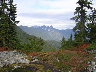
The Lions, known as Ch'ích'iyúy Elx̱wíḵn in the Sḵwx̱wú7mesh (Squamish) language, are a pair of pointed peaks along the North Shore Mountains in Metro Vancouver, British Columbia, Canada. They can be seen from much of the Greater Vancouver area, as far as Robert Burnaby Park in East Burnaby, south to parts of Surrey, and from the west on the Howe Sound Islands and the Sunshine Coast. Along with the Lions Gate Bridge named in their honour, these twin summits have become one of the most recognizable Vancouver landmarks. The city's BC Lions CFL football team is also named in their honour. Lions Gate Entertainment which was founded in Vancouver in July, 1997 is also named for the peaks.

The Fannin Range is a small mountain range in the Pacific Ranges of the Coast Mountains of British Columbia, Canada. Lying between the Seymour River and the glacial fjord Indian Arm, the range extends from the slopes of Mount Seymour on the Burrard Inlet to the district of North Vancouver more than 34 km (21 mi) north to the headwaters of the Indian River. It is named after the naturalist John Fannin It is commonly considered to be part of the North Shore Mountains.

Mount Elsay is a mountain in southwestern British Columbia, Canada, located near the middle of Mount Seymour Provincial Park in the District of North Vancouver. It is a part of the North Shore Mountains, rising from the shores of Indian Arm to a summit of 1,419 m (4,656 ft). It is named after nearby Elsay Lake and Creek. These names are thought to derive from a Scottish settler, probably after a place name in Scotland.

The Britannia Range is a small mountain range of the Coast Mountains that runs along the eastern shore of Howe Sound just north of Vancouver, British Columbia, Canada. It is a subrange of the Pacific Ranges and often considered part of the North Shore Mountains. The range is bounded by the Howe Sound to the west, the Stawamus River to the north, Loch Lomond on the upper Seymour River to the east, and Deeks Lake to the south. However, some official maps extend the range further south of these boundaries and many local sources such as hiking guidebooks will often include all of the peaks along the Howe Sound between Deeks Lake and Cypress Mountain as part of the range.
Grouse Mountain is one of the North Shore Mountains of the Pacific Ranges in the District Municipality of North Vancouver, British Columbia, Canada. With a maximum elevation of over 1,200m (4,100ft) at its peak, the mountain is the site of an alpine ski area, Grouse Mountain Resort, which overlooks Metro Vancouver and has four chairlifts servicing 33 runs. In the summer, Grouse Mountain Resort features lumberjack shows, the "Birds in Motion" birds of prey demonstration, a chairlift ride, disc golf, mountain biking, zip lining, tandem paragliding, helicopter tours, and guided ecowalks. Year-round operations include a 100-seat mountaintop theatre and a wildlife refuge. The mountain operates two aerial tramways, known officially as the Skyride. The Blue Skyride is used mainly for freight transportation, while public access to the mountain top is provided by the Swiss-built Garaventa Red Skyride, which has a maximum capacity of 101 passengers. Summer access is also provided by the 2.9 kilometre Grouse Grind hiking trail, which is open for hiking from May to October. Similar to the nearby Capilano Suspension bridge, Grouse Mountain can be accessed via a free, regular shuttle bus that runs from 'Canada Place' in downtown Vancouver.

Unnecessary Mountain, also called Mount Unnecessary, is a peak in the North Shore Mountains near Vancouver, British Columbia, Canada and a popular hiking destination. Its two summits are within Cypress Provincial Park, accessible via the Howe Sound Crest Trail and the Unnecessary Mountain Trail from Lions Bay. The taller south summit has an elevation of 1,548 m and its north summit is slightly lower at 1,543 m.
Lynn Headwaters Regional Park is an area of North Vancouver, British Columbia, and is the largest of twenty-two regional parks in Metro Vancouver. At 9,216.5 acres (3,729.8 ha), the park boasts a variety of trails for hikers, including easy, intermediate, and challenging. The trails are colour-coded and range from 3 kilometres (1.9 mi) to 21.4 kilometres (13.3 mi). Bikes and dogs are allowed on select trails.

Mount Seymour Provincial Park is a park in Vancouver, British Columbia's North Shore Mountains. With an area of 35 square kilometres, it is located approximately 15 kilometres north of Downtown Vancouver. The park, named after Frederick Seymour, was established in 1936. Mount Seymour Provincial Park provides visitors with a variety of recreational activities and animals with natural habitat.

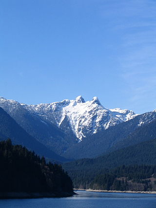
The Metro Vancouver watersheds, also known as the Greater Vancouver watersheds, supply potable water to approximately 2.7 million residents in the Lower Mainland of British Columbia. They provide tap water to a land area covering more than 2,600 square kilometres (1,000 sq mi), serving a total of 21 member municipalities, one electoral district, and one treaty First Nation. From west to east, the watersheds are the Capilano, the Seymour, and the Coquitlam. They are located in the North Shore Mountains and Coquitlam Mountain, respectively. Each watershed possesses a reservoir for water storage purposes, under the control of Metro Vancouver. The reservoirs are supplied by about 3.5 metres (11 ft) of rain and 4.5 metres (15 ft) of snowpack annually. Two additional off-catchment areas under control of Metro Vancouver contribute to the water supply. The watersheds have a long history of controversies surrounding logging, highway development, and salmon run conservation.
The Howe Sound Crest Trail is a rugged 32.8-kilometre (20.4 mi) wilderness hiking trail located near Vancouver, British Columbia, Canada. The trail is located mostly within Cypress Provincial Park and is typically traveled as a single or multi-day hike from south to north, or as a means to access peaks along the route such as Mount Brunswick. It gets its name because it follows the crests of the North Shore Mountains that rise above the Howe Sound, the deep saltwater glacial fjord which parallels the trail to the west. It can be accessed in the south from Cypress Mountain Ski Area and in the north from the Sea to Sky Highway at Porteau Road, or via many intersecting trails that start at Lions Bay.

Mount Burwell is a 1,541-metre (5,056 ft) mountain summit in the Metro Vancouver Regional District of British Columbia, Canada. It is part of the North Shore Mountains, which are a small subrange of the Pacific Ranges of the Coast Mountains.


