Related Research Articles
Whistler Blackcomb is a ski resort located in Whistler, British Columbia, Canada. By many measures, it is the largest ski resort in North America and has the greatest uphill lift capacity. It features the Peak 2 Peak Gondola for moving between Whistler and Blackcomb mountains at the top. With its capacity, Whistler Blackcomb is a busy ski resort, often surpassing two million visitors a year.

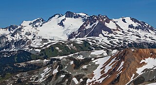
Mount Garibaldi is a dormant stratovolcano in the Garibaldi Ranges of the Pacific Ranges in southwestern British Columbia, Canada. It has a maximum elevation of 2,678 metres and rises above the surrounding landscape on the east side of the Cheakamus River in New Westminster Land District. In addition to the main peak, Mount Garibaldi has two named sub-peaks. Atwell Peak is a sharp, conical peak slightly higher than the more rounded peak of Dalton Dome. Both were volcanically active at different times throughout Mount Garibaldi's eruptive history. The northern and eastern flanks of Mount Garibaldi are obscured by the Garibaldi Névé, a large snowfield containing several radiating glaciers. Flowing from the steep western face of Mount Garibaldi is the Cheekye River, a tributary of the Cheakamus River. Opal Cone on the southeastern flank is a small volcanic cone from which a lengthy lava flow descends. The western face is a landslide feature that formed in a series of collapses between 12,800 and 11,500 years ago. These collapses resulted in the formation of a large debris flow deposit that fans out into the Squamish Valley.

Garibaldi Provincial Park, also called Garibaldi Park, is a wilderness park located on the coastal mainland of British Columbia, Canada, 70 kilometres (43.5 mi) north of Vancouver. It was established in 1920 and named a Class A Provincial Park of British Columbia in 1927. The park is a popular destination for outdoor recreation, with over 30,000 overnight campers and over 106,000 day users in the 2017/2018 season.

The Pacific Ranges are the southernmost subdivision of the Coast Mountains portion of the Pacific Cordillera. Located entirely within British Columbia, Canada, they run northwest from the lower stretches of the Fraser River to Bella Coola and Burke Channel, north of which are the Kitimat Ranges. The Coast Mountains lie between the Interior Plateau and the Coast of British Columbia.
The Garibaldi Ranges are the next-to-southwesternmost subdivision of the Pacific Ranges of the Coast Mountains; only the North Shore Mountains are farther southwest. They lie between the valley formed by the pass between the Cheakamus River and Green River on the west and the valley of the Lillooet River on the east, and extend south into Maple Ridge, an eastern suburb of Vancouver, and the northern District of Mission. To their south are the North Shore Mountains overlooking Vancouver while to their southeast are the Douglas Ranges.

Whistler Mountain is a mountain in the Fitzsimmons Range of the Pacific Ranges of the Coast Mountains, located on the northwestern edge of Garibaldi Provincial Park. It is the location of the Whistler-Blackcomb ski resort and the town of Whistler, British Columbia, Canada, and played host to the 2010 Winter Olympics.

Wedge Mountain, 2,895 m (9,498 ft) prominence: 2,249 m (7,379 ft), often locally referred to as The Wedge or simply "Wedge", is the highest summit in the Garibaldi Ranges and therefore also Garibaldi Provincial Park, and is among the nearest of the many peaks visible from the Whistler Blackcomb Ski Area, lying north across the valley of Billygoat Pass from the Spearhead Range, which includes one of that resort's two flagship mountains, Blackcomb. It was named for its distinctive wedge shape by the Garibaldi Park Board in 1932 in preference to Mount Vancouver, which had been submitted earlier. It is part of an unnamed range forming the most northerly group of peaks in the Garibaldi Ranges, the other two most notable being Mount Weart, known as the Armchair because of its shape, and Mount Currie, which overlooks the First Nations Reserve of the same name and the neighbouring town of Pemberton. Wedge's very high prominence is defined by the divide between the Green and Cheakamus Rivers at a locality at the south end of Alta Lake known as Tokum Corners.

The Spearhead is a 2,457 m (8,061 ft) peak in the Garibaldi Ranges of British Columbia, Canada, and is one of the main summits of the Blackcomb Mountain portion of the Whistler Blackcomb ski resort, located at the apex of the Blackcomb and Spearhead Glaciers, which is named for it. It also is the namesake of the Spearhead Range, which is the short range flanking the north side of Fitzsimmons Creek and ending on its northwest end at Blackcomb Mountain. The mountain's name was officially adopted on August 27, 1965, by the Geographical Names Board of Canada.

The Spearhead Range is a short subrange of the Garibaldi Ranges of southwestern British Columbia, Canada, adjacent to the resort town of Whistler, British Columbia and ending at its northwestern apex in Blackcomb Mountain, one of two mountains forming the Whistler Blackcomb ski resort. Other notable summits are Tremor Mountain, The Spearhead, Mount Macbeth, Decker Mountain, Mount Trorey, Phalanx Mountain and Shatter, Shudder, Quiver and other similarly named peaks and glaciers. The range was named by Don and Phyllis Munday as the range's peaks resembled spearheads rising from the alpine fog. To the north of the range is Lone Goat Pass, formed by Wedge Creek and Lone Goat Creek, which is fed by the Spearhead Glacier, the largest glacier in the range. The valley of Fitzsimmons Creek is on the range's south side, and is the location of the Whistler Sliding Centre, which was built for the 2010 Winter Olympics.

Mount Cayley is an eroded but potentially active stratovolcano in the Pacific Ranges of southwestern British Columbia, Canada. Located 45 km (28 mi) north of Squamish and 24 km (15 mi) west of Whistler, the volcano resides on the edge of the Powder Mountain Icefield. It consists of massif that towers over the Cheakamus and Squamish river valleys. All major summits have elevations greater than 2,000 m (6,600 ft), Mount Cayley being the highest at 2,385 m (7,825 ft). The surrounding area has been inhabited by indigenous peoples for more than 7,000 years while geothermal exploration has taken place there for the last four decades.
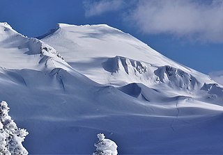
Overlord Mountain is a 2,625-metre (8,612-foot) glacier-clad peak located in the Garibaldi Ranges of the Coast Mountains, in Garibaldi Provincial Park of southwestern British Columbia, Canada. It is the highest point of the Fitzsimmons Range, which is a subset of the Garibaldi Ranges, and can be readily seen from the Whistler Blackcomb ski area. It is situated 15 km (9 mi) southeast of Whistler, and its nearest higher peak is Mount Macbeth, 3 km (2 mi) to the north-northeast. The Benvolio Glacier rests below the south aspect of the summit, the Fitzsimmons Glacier on the east aspect, and the expansive Overlord Glacier spans the northern and western aspects of the mountain. Precipitation runoff from the peak and meltwater from its glaciers drains into tributaries of the Cheakamus River. The first ascent of the mountain was made in 1923 by Phyllis Munday and Don Munday via the Benvolio Glacier. The mountain's descriptive name was recommended by the Garibaldi Park Board and officially adopted on September 2, 1930, by the Geographical Names Board of Canada.

Mount Fitzsimmons is a 2,603-metre (8,540-foot) glacier-clad peak located in the Garibaldi Ranges of the Coast Mountains, in Garibaldi Provincial Park of southwestern British Columbia, Canada. It is the third-highest point of the Fitzsimmons Range, which is a subset of the Garibaldi Ranges. It is situated 15 km (9 mi) southeast of Whistler, and its nearest higher peak is Mount Benvolio, 0.5 km (0 mi) to the west-southwest. The Diavolo Glacier spreads out below the southeast aspect of the summit, and the Fitzsimmons Glacier descends the northwest slopes. Precipitation runoff from the peak and meltwater from its glaciers drains into tributaries of the Cheakamus River. The first ascent of the mountain was made on August 19, 1924, by a party of the British Columbia Mountaineering Club. The peak was named for prospector James Fitzsimmons, who built a trail along Fitzsimmons Creek in an effort to haul supplies to a small copper mine he staked and worked. The mountain's name was officially adopted on September 2, 1930, by the Geographical Names Board of Canada.
Mount Macbeth is a 2,639-metre (8,658-foot) glacier-clad peak located in the Garibaldi Ranges of the Coast Mountains, in Garibaldi Provincial Park of southwestern British Columbia, Canada. It is part of the Spearhead Range, which is a subset of the Garibaldi Ranges. It is situated 14 km (9 mi) southeast of Whistler, and 2 km (1 mi) south of Tremor Mountain, which is the highest point in the Spearhead Range. The Naden Glacier spreads out below the eastern aspect of the summit, the Macbeth Glacier lies below the south aspect, and the Curtain Glacier descends the northern slope. Precipitation runoff from the peak and meltwater from its glaciers drains into Fitzsimmons Creek which is a tributary of the Cheakamus River. Macbeth is most often climbed as part of the Spearhead Traverse. The first ascent of the mountain was made in 1969 by P. Starr, E. Bass, B. Ellis, and P. Macec via the northeast ridge. The peak was named in 1964 by an Alpine Club of Canada climbing party, to commemorate the 400th anniversary of William Shakespeare's birth. The mountain's name was officially adopted on August 27, 1965, by the Geographical Names Board of Canada.

Mount Davidson is a 2,516-metre (8,255-foot) mountain summit located in the Garibaldi Ranges of the Coast Mountains, in Garibaldi Provincial Park of southwestern British Columbia, Canada. Visible from the Whistler Blackcomb ski area, it is situated 18 km (11 mi) south of Whistler, and its nearest higher peak is Castle Towers Mountain, 3 km (2 mi) to the west. The Cheakamus Glacier lies between these two summits, and precipitation runoff from the peak and meltwater from the glacier drains into tributaries of the Cheakamus River. The first ascent of the mountain was made in 1929 by Neal M. Carter and Emmy Milledge. The mountain is named after Professor John Davidson, who contributed a large amount of botanical knowledge about Garibaldi Park. The mountain's name was officially adopted on September 2, 1930, by the Geographical Names Board of Canada.

Decker Mountain is a 2,421-metre (7,943-foot) flat-topped peak located in the Garibaldi Ranges of the Coast Mountains, in Garibaldi Provincial Park of southwestern British Columbia, Canada. It is part of the Spearhead Range, which is a subset of the Garibaldi Ranges. It is situated 9 km (6 mi) southeast of Whistler, and 3.9 km (2 mi) west-northwest of Tremor Mountain, which is the highest point in the Spearhead Range. Precipitation runoff from the south side of the peak drains into Fitzsimmons Creek which is a tributary of the Cheakamus River, and meltwater from the Decker Glacier on the northeastern slope drains to Wedge Creek.

Mount Benvolio is a 2,613-metre (8,573-foot) glacier-clad peak located in the Garibaldi Ranges of the Coast Mountains, in Garibaldi Provincial Park of southwestern British Columbia, Canada. It is the second-highest point of the Fitzsimmons Range, which is a subset of the Garibaldi Ranges. It is situated 15 km (9 mi) southeast of Whistler, and its nearest higher peak is Overlord Mountain, 0.7 km (0 mi) to the northwest. The Benvolio Glacier is set on the western slope of the peak, the Diavolo Glacier spreads out below the eastern aspect of the summit, and the Fitzsimmons Glacier descends the north slope. Precipitation runoff from the peak and meltwater from its glaciers drains into tributaries of the Cheakamus River.
Cheakamus Mountain is a 2,588-metre (8,491-foot) glacier-clad peak located in the Garibaldi Ranges of the Coast Mountains, in Garibaldi Provincial Park of southwestern British Columbia, Canada. It is the fourth-highest peak of the Fitzsimmons Range, which is a subset of the Garibaldi Ranges. It is situated 16 km (10 mi) southeast of Whistler, and its nearest higher peak is Mount Benvolio, 1.65 km (1 mi) to the northwest. The Diavolo Glacier spreads out below the north aspect of the peak, and precipitation runoff from the peak with meltwater from the glacier drains into tributaries of the Cheakamus River. The peak was named in association with the river, which in turn is anglicized from Tseearkamisht, a Squamish word meaning "people who use the cedar rope fishing net". The mountain's name was officially adopted on September 2, 1930, by the Geographical Names Board of Canada. The first ascent of the mountain was made in 1950 by Roy Hooley, Jimmy Kilborn, and Ian Kirk.
Mount Trorey is a 2,461-metre (8,074-foot) mountain summit located in British Columbia, Canada.
Whirlwind Peak is a 2,427-metre (7,963-foot) mountain summit in southwestern British Columbia, Canada.

Diavolo Peak is a 2,569-metre (8,428-foot) mountain located in British Columbia, Canada.
References
- ↑ "Overlord Mountain". Bivouac.com. Retrieved 2009-04-03.
- "Fitzsimmons Range". BC Geographical Names .
- Fitzsimmons Range in the Canadian Mountain Encyclopedia
- Mount Fitzsimmons in the Canadian Mountain Encyclopedia
- Mount Benvolio in the Canadian Mountain Encyclopedia
- Cheakamus Mountain in the Canadian Mountain Encyclopedia
| | This article about a location on the South Coast of British Columbia, Canada is a stub. You can help Wikipedia by expanding it. |