Mount Fitzsimmons (British Columbia)

Last updated
Mount Fitzsimmons
Mount Fitzsimmons.jpg
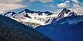
Mount Fitzsimmons and Fitzsimmons Glacier as seen from Overlord Mountain
Highest point
Elevation 2,603 m (8,540 ft) [1]
Prominence 133 m (436 ft) [1]
Parent peak Overlord Mountain (2625 m) [1]
Listing Mountains of British Columbia
Coordinates 50°0′50″N122°48′24″W / 50.01389°N 122.80667°W / 50.01389; -122.80667 [2]
Geography
Canada British Columbia relief location map.jpg
Red triangle with thick white border.svg
Mount Fitzsimmons
Location in British Columbia
Canada relief map 2.svg
Red triangle with thick white border.svg
Mount Fitzsimmons
Mount Fitzsimmons (Canada)
Country Canada
Province British Columbia
District New Westminster Land District
Protected area Garibaldi Provincial Park
Parent range Fitzsimmons Range
Garibaldi Ranges
Coast Ranges
Topo map NTS 92J2 Whistler [2]
Climbing
First ascent 1924 by BCMC party [1]
Easiest route class 2-3 via Diavolo Glacier

Mount Fitzsimmons is a 2,603-metre (8,540-foot) glacier-clad peak located in the Garibaldi Ranges of the Coast Mountains, in Garibaldi Provincial Park of southwestern British Columbia, Canada. It is the third-highest point of the Fitzsimmons Range, which is a subset of the Garibaldi Ranges. [3] It is situated 15 km (9 mi) southeast of Whistler, and its nearest higher peak is Mount Benvolio, 0.5 km (0 mi) to the west-southwest. [3] The Diavolo Glacier spreads out below the southeast aspect of the summit, and the Fitzsimmons Glacier descends the northwest slopes. Precipitation runoff from the peak and meltwater from its glaciers drains into tributaries of the Cheakamus River. The first ascent of the mountain was made on August 19, 1924, by a party of the British Columbia Mountaineering Club. [4] The peak was named for prospector James Fitzsimmons, who built a trail along Fitzsimmons Creek in an effort to haul supplies to a small copper mine he staked and worked. [4] The mountain's name was officially adopted on September 2, 1930, by the Geographical Names Board of Canada. [2]

Contents

Climate

Mt. Fitzsimmons' NE face Mt. Fitzsimmons of Spearhead.jpg
Mt. Fitzsimmons' NE face

Based on the Köppen climate classification, Mount Fitzsimmons is located in the marine west coast climate zone of western North America. [5] Most weather fronts originate in the Pacific Ocean, and travel east toward the Coast Mountains where they are forced upward by the range (Orographic lift), causing them to drop their moisture in the form of rain or snowfall. As a result, the Coast Mountains experience high precipitation, especially during the winter months in the form of snowfall. Winter temperatures can drop below −20 °C with wind chill factors below −30 °C. The months July through September offer the most favorable weather for climbing Mount Fitzsimmons.

Climbing Routes

Established climbing routes on Mount Fitzsimmons : [1]

See also

Related Research Articles

<span class="mw-page-title-main">The Spearhead</span>

The Spearhead is a 2,457 m (8,061 ft) peak in the Garibaldi Ranges of British Columbia, Canada, and is one of the main summits of the Blackcomb Mountain portion of the Whistler Blackcomb ski resort, located at the apex of the Blackcomb and Spearhead Glaciers, which is named for it. It also is the namesake of the Spearhead Range, which is the short range flanking the north side of Fitzsimmons Creek and ending on its northwest end at Blackcomb Mountain. The mountain's name was officially adopted on August 27, 1965, by the Geographical Names Board of Canada.

<span class="mw-page-title-main">Alpha Mountain</span> Mountain in British Columbia, Canada

Alpha Mountain is a 2,302-metre (7,552-foot) summit located in the Tantalus Range, in Tantalus Provincial Park, in southwestern British Columbia, Canada. It is situated 14 km (9 mi) northwest of Squamish, and 4.6 km (3 mi) southeast of Mount Tantalus, which is the highest peak in the Tantalus Range. Its nearest higher peak is Serratus Mountain, 1.9 km (1 mi) to the west. The Serratus Glacier lies to the west of Alpha, unnamed glaciers lie on the northern and eastern slopes, and Lake Lovely Water lies below the south slope. Precipitation runoff from the peak drains into tributaries of the Squamish River.

<span class="mw-page-title-main">Mount Niobe</span> Mountain in British Columbia, Canada

Mount Niobe is a 2,021-metre (6,631-foot) summit located in the Tantalus Range, in Tantalus Provincial Park, in southwestern British Columbia, Canada. It is situated 10 km (6 mi) northwest of Squamish, and 7.2 km (4 mi) southeast of Mount Tantalus, which is the highest peak in the Tantalus Range. Its nearest higher peak is Lydia Mountain, 2.03 km (1 mi) to the west-northwest, and Omega Mountain lies 1.1 km (1 mi) to the east. Lake Lovely Water lies below the northern slope of the peak and precipitation runoff from the peak drains into tributaries of the Squamish River. The first ascent of the mountain was made in 1910 by E. Kingsford-Smith and G. Warren via the south side. The mountain's name was officially adopted on June 6, 1957, by the Geographical Names Board of Canada. The mountain was named for Niobe, daughter of Tantalus in Greek mythology, with several peaks in the Tantalus Range being named for family members of Tantalus.

<span class="mw-page-title-main">Ossa Mountain</span> Mountain in British Columbia, Canada

Ossa Mountain is a 2,261-metre (7,418-foot) summit located in the Tantalus Range, in Tantalus Provincial Park, in southwestern British Columbia, Canada. It is situated 21 km (13 mi) northwest of Squamish, and 3.54 km (2 mi) north-northwest of Mount Tantalus, which is the highest peak in the Tantalus Range. Its nearest higher peak is Pelion Mountain, 0.77 km (0 mi) to the east. Unnamed glaciers lie on the northern and eastern slopes. Precipitation runoff from the peak drains into tributaries of the Squamish River and Clowhom River. The first ascent of the mountain was made on July 25, 1960, by Dick Chambers, Jack Bryan, and Howie Rode via the east ridge. The mountain names in the Tantalus Range have a Greek mythology theme, and Ossa Mountain was named for legendary Mount Ossa in Thessaly, upon which the Aloadaes are said to have attempted to pile Mount Pelion on top of Mount Ossa in their attempt to scale Olympus, home of the Greek gods. The mountain's name was officially adopted on June 6, 1957, by the Geographical Names Board of Canada.

<span class="mw-page-title-main">Mount Dione</span> Mountain in British Columbia, Canada

Mount Dione is a 2,589-metre (8,494-foot) summit located in the Tantalus Range, in Tantalus Provincial Park, in southwestern British Columbia, Canada. It is situated 17 km (11 mi) northwest of Squamish, and 0.24 km (0 mi) north of Mount Tantalus, which is its nearest higher peak and the highest peak in the Tantalus Range. The Dione Glacier lies on the southern slope, and the Rumbling Glacier lies to the northeast. Precipitation runoff from the peak drains east into tributaries of the Squamish River, or west into tributaries of the Clowhom River. The first ascent of the mountain was made in 1916 by Tom Fyles and his brother, John Fyles, via the southeast ridge. The mountain names in the Tantalus Range have a Greek mythology theme, and Mount Dione was named for Dione, the wife of Tantalus. The mountain's name was submitted by Neal Carter of the British Columbia Mountaineering Club, and was officially adopted on June 6, 1957, by the Geographical Names Board of Canada.

<span class="mw-page-title-main">Mount Matier</span> Mountain in the country of Canada

Mount Matier is a prominent 2,783-metre (9,131-foot) mountain summit located in the Coast Mountains, in Joffre Lakes Provincial Park, in southwestern British Columbia, Canada. It is the highest point of the Joffre Group, which is a subset range of the Coast Mountains. It is situated 26 km (16 mi) east of Pemberton, and 9 km (6 mi) northeast of Lillooet Lake. Its nearest higher peak is Mount Weart, 30 km (19 mi) to the southwest. The slopes of the mountain are covered by the Matier Glacier on the northwest, Anniversary Glacier on the northeast, Twin One Glacier on the southeast, and Hartzell Glacier to the south. Precipitation runoff from the peak drains into Joffre Creek and Twin One Creek, both tributaries of the Lillooet River.

<span class="mw-page-title-main">Joffre Peak</span> Mountain in the country of Canada

Joffre Peak is a 2,721-metre (8,927-foot) mountain summit located in the Coast Mountains, in Joffre Lakes Provincial Park, in southwestern British Columbia, Canada. It is the second-highest point of the Joffre Group, which is a subset of the Lillooet Ranges. It is situated 26 km (16 mi) east of Pemberton and 11 km (7 mi) northeast of Lillooet Lake. Joffre is more notable for its steep rise above local terrain than for its absolute elevation as topographic relief is significant with the summit rising 1,500 meters (4,920 ft) above Cayoosh Creek in 4 km (2.5 mi). The nearest higher peak is Mount Matier, 1.6 km (1 mi) to the south. The mountain's climate supports the Matier Glacier on the southwest slope, and the Anniversary Glacier on the southeast slope. Precipitation runoff from the peak drains into Joffre Creek and Cayoosh Creek which are both within the Fraser River watershed.

<span class="mw-page-title-main">Slalok Mountain</span> Mountain in British Columbia, Canada

Slalok Mountain, originally known as Rex's Pillar, is a 2,653-metre (8,704-foot) mountain summit located in the Coast Mountains, in Joffre Lakes Provincial Park, in southwestern British Columbia, Canada. It is the third-highest point of the Joffre Group, which is a subset of the Lillooet Ranges. It is situated 24 km (15 mi) east of Pemberton, and 8 km (5 mi) northeast of Lillooet Lake. It is 4 km (2 mi) northeast of Duffey Peak and the nearest higher peak is Mount Matier, 1.9 km (1 mi) to the east. Precipitation runoff from the peak drains into Joffre Creek and Twin One Creek, both tributaries of the Lillooet River. The first ascent of the mountain was made in 1963 by C. Adam, T. Anderson, and G. Richardson. The mountain's name Slalok is the traditional name for the settlement of nearby Mount Currie. The name was officially adopted on June 11, 1979, by the Geographical Names Board of Canada. The mountain and its climate supports the Matier Glacier, Stonecrop Glacier, and Tszil Glacier on the northern slopes.

<span class="mw-page-title-main">Mount Weart</span> Triple summit mountain in the country of Canada

Mount Weart is a 2,835-metre (9,301-foot) triple-summit mountain located in the Garibaldi Ranges of the Coast Mountains, in northwestern Garibaldi Provincial Park of southwestern British Columbia, Canada. It is situated 14 km (9 mi) northeast of Whistler, and its nearest higher peak is Wedge Mountain, 3.7 km (2 mi) to the south, which is the only peak within the park higher than Weart. The Armchair Glacier rests below the west aspect of the summit, and the massive Weart Glacier spans the northern and eastern aspects of the mountain. Precipitation runoff from the peak and meltwater from the glaciers drains into Wedgemount Lake and tributaries of the Lillooet River.

<span class="mw-page-title-main">Overlord Mountain</span> Mountain in the country of Canada

Overlord Mountain is a 2,625-metre (8,612-foot) glacier-clad peak located in the Garibaldi Ranges of the Coast Mountains, in Garibaldi Provincial Park of southwestern British Columbia, Canada. It is the highest point of the Fitzsimmons Range, which is a subset of the Garibaldi Ranges, and can be readily seen from the Whistler Blackcomb ski area. It is situated 15 km (9 mi) southeast of Whistler, and its nearest higher peak is Mount Macbeth, 3 km (2 mi) to the north-northeast. The Benvolio Glacier rests below the south aspect of the summit, the Fitzsimmons Glacier on the east aspect, and the expansive Overlord Glacier spans the northern and western aspects of the mountain. Precipitation runoff from the peak and meltwater from its glaciers drains into tributaries of the Cheakamus River. The first ascent of the mountain was made in 1923 by Phyllis Munday and Don Munday via the Benvolio Glacier. The mountain's descriptive name was recommended by the Garibaldi Park Board and officially adopted on September 2, 1930, by the Geographical Names Board of Canada.

<span class="mw-page-title-main">Mount Macbeth</span> Mountain in British Columbia, Canada

Mount Macbeth is a 2,639-metre (8,658-foot) glacier-clad peak located in the Garibaldi Ranges of the Coast Mountains, in Garibaldi Provincial Park of southwestern British Columbia, Canada. It is part of the Spearhead Range, which is a subset of the Garibaldi Ranges. It is situated 14 km (9 mi) southeast of Whistler, and 2 km (1 mi) south of Tremor Mountain, which is the highest point in the Spearhead Range. The Naden Glacier spreads out below the eastern aspect of the summit, the Macbeth Glacier lies below the south aspect, and the Curtain Glacier descends the northern slope. Precipitation runoff from the peak and meltwater from its glaciers drains into Fitzsimmons Creek which is a tributary of the Cheakamus River. Macbeth is most often climbed as part of the Spearhead Traverse. The first ascent of the mountain was made in 1969 by P. Starr, E. Bass, B. Ellis, and P. Macec via the northeast ridge. The peak was named in 1964 by an Alpine Club of Canada climbing party, to commemorate the 400th anniversary of William Shakespeare's birth. The mountain's name was officially adopted on August 27, 1965, by the Geographical Names Board of Canada.

<span class="mw-page-title-main">Mount Davidson (British Columbia)</span>

Mount Davidson is a 2,516-metre (8,255-foot) mountain summit located in the Garibaldi Ranges of the Coast Mountains, in Garibaldi Provincial Park of southwestern British Columbia, Canada. Visible from the Whistler Blackcomb ski area, it is situated 18 km (11 mi) south of Whistler, and its nearest higher peak is Castle Towers Mountain, 3 km (2 mi) to the west. The Cheakamus Glacier lies between these two summits, and precipitation runoff from the peak and meltwater from the glacier drains into tributaries of the Cheakamus River. The first ascent of the mountain was made in 1929 by Neal M. Carter and Emmy Milledge. The mountain is named after Professor John Davidson, who contributed a large amount of botanical knowledge about Garibaldi Park. The mountain's name was officially adopted on September 2, 1930, by the Geographical Names Board of Canada.

<span class="mw-page-title-main">Decker Mountain</span> Mountain in the country of Canada

Decker Mountain is a 2,421-metre (7,943-foot) flat-topped peak located in the Garibaldi Ranges of the Coast Mountains, in Garibaldi Provincial Park of southwestern British Columbia, Canada. It is part of the Spearhead Range, which is a subset of the Garibaldi Ranges. It is situated 9 km (6 mi) southeast of Whistler, and 3.9 km (2 mi) west-northwest of Tremor Mountain, which is the highest point in the Spearhead Range. Precipitation runoff from the south side of the peak drains into Fitzsimmons Creek which is a tributary of the Cheakamus River, and meltwater from the Decker Glacier on the northeastern slope drains to Wedge Creek.

<span class="mw-page-title-main">Mount Benvolio</span> Mountain in the country of Canada

Mount Benvolio is a 2,613-metre (8,573-foot) glacier-clad peak located in the Garibaldi Ranges of the Coast Mountains, in Garibaldi Provincial Park of southwestern British Columbia, Canada. It is the second-highest point of the Fitzsimmons Range, which is a subset of the Garibaldi Ranges. It is situated 15 km (9 mi) southeast of Whistler, and its nearest higher peak is Overlord Mountain, 0.7 km (0 mi) to the northwest. The Benvolio Glacier is set on the western slope of the peak, the Diavolo Glacier spreads out below the eastern aspect of the summit, and the Fitzsimmons Glacier descends the north slope. Precipitation runoff from the peak and meltwater from its glaciers drains into tributaries of the Cheakamus River.

<span class="mw-page-title-main">Pelion Mountain</span>

Pelion Mountain is a 2,312-metre (7,585-foot) summit located in the Tantalus Range, in Tantalus Provincial Park, in southwestern British Columbia, Canada. It is situated 21 km (13 mi) northwest of Squamish, 0.8 km (0 mi) east of Ossa Mountain, and 5.5 km (3 mi) north-northwest of Mount Tantalus, which is its nearest higher peak and the highest peak in the Tantalus Range. Unnamed glaciers surround the peak and precipitation runoff from the peak drains into tributaries of the Squamish River and Clowhom River. The first ascent of the mountain was made in 1944 by V. Brink and B. McLellan. The mountain names in the Tantalus Range have a Greek mythology theme, and Pelion Mountain was named for the legendary Pelion mountain in Thessaly, upon which the Aloadaes are said to have attempted to pile Mount Pelion on top of Mount Ossa in their attempt to scale Olympus, home of the Greek gods. The mountain's name was officially adopted on June 6, 1957, by the Geographical Names Board of Canada.

<span class="mw-page-title-main">Tremor Mountain</span> Mountain in the country of Canada

Tremor Mountain is a prominent 2,691-metre (8,829-foot) summit located in the Garibaldi Ranges of the Coast Mountains, in Garibaldi Provincial Park of southwestern British Columbia, Canada. It is the highest point of the Spearhead Range, which is a subset of the Garibaldi Ranges. It is situated 13 km (8 mi) southeast of Whistler, and 8.7 km (5 mi) south of Wedge Mountain, its nearest higher peak. Precipitation runoff from the south side of the peak as well as meltwater from the Platform Glacier drains into Fitzsimmons Creek which is a tributary of the Cheakamus River. Meltwater from the Tremor Glacier on the northwestern slope drains to Wedge Creek, and meltwater from the Shudder Glacier on the northeast slope drains into Billygoat Creek, a tributary of the Lillooet River. Tremor Mountain is often climbed as part of the Spearhead Traverse. The first ascent of the mountain was made in 1928 by A.J. Campbell Garibaldi survey party. The mountain's name origin refers to unexplained earth tremors when the first ascent party was on the summit. The mountain's name was officially adopted on September 6, 1951, by the Geographical Names Board of Canada.

<span class="mw-page-title-main">Mount Cook (British Columbia)</span> Mountain in the country of Canada

Mount Cook is a 2,676-metre (8,780-foot) mountain located in the Garibaldi Ranges of the Coast Mountains, in northwestern Garibaldi Provincial Park of southwestern British Columbia, Canada. It is situated above the north shore of Wedgemount Lake, 13 km (8 mi) northeast of Whistler, and its nearest higher peak is Mount Weart, 1.2 km (1 mi) to the southeast. The Armchair Glacier is set between Cook and Weart, and the Weart Glacier rests on the northern slope of Cook. Precipitation runoff from the peak and meltwater from the glaciers drains into Wedgemount Lake and Green River.

<span class="mw-page-title-main">Cheakamus Mountain</span> Mountain in British Columbia, Canada

Cheakamus Mountain is a 2,588-metre (8,491-foot) glacier-clad peak located in the Garibaldi Ranges of the Coast Mountains, in Garibaldi Provincial Park of southwestern British Columbia, Canada. It is the fourth-highest peak of the Fitzsimmons Range, which is a subset of the Garibaldi Ranges. It is situated 16 km (10 mi) southeast of Whistler, and its nearest higher peak is Mount Benvolio, 1.65 km (1 mi) to the northwest. The Diavolo Glacier spreads out below the north aspect of the peak, and precipitation runoff from the peak with meltwater from the glacier drains into tributaries of the Cheakamus River. The peak was named in association with the river, which in turn is anglicized from Tseearkamisht, a Squamish word meaning "people who use the cedar rope fishing net". The mountain's name was officially adopted on September 2, 1930, by the Geographical Names Board of Canada. The first ascent of the mountain was made in 1950 by Roy Hooley, Jimmy Kilborn, and Ian Kirk.

<span class="mw-page-title-main">Mount Trorey</span> Mountain in the country of Canada

Mount Trorey is a 2,461-metre (8,074-foot) mountain summit located in British Columbia, Canada.

<span class="mw-page-title-main">Diavolo Peak</span>

Diavolo Peak is a 2,569-metre (8,428-foot) mountain located in British Columbia, Canada.

References

Left to right: Mount Fitzsimmons, Overlord Mountain, and Fissile Peak Overlord Mountain over forest.jpg
Left to right: Mount Fitzsimmons, Overlord Mountain, and Fissile Peak
  1. 1 2 3 4 5 "Mount Fitzsimmons". Bivouac.com. Retrieved 2019-11-15.
  2. 1 2 3 "Mount Fitzsimmons". Geographical Names Data Base . Natural Resources Canada . Retrieved 2019-11-15.
  3. 1 2 "Mount Fitzsimmons, British Columbia". Peakbagger.com. Retrieved 2019-11-15.
  4. 1 2 "Mount Fitzsimmons". BC Geographical Names . Retrieved 2019-11-12.
  5. Peel, M. C.; Finlayson, B. L.; McMahon, T. A. (2007). "Updated world map of the Köppen−Geiger climate classification". Hydrol. Earth Syst. Sci. 11. ISSN   1027-5606.