
Queen Charlotte Sound is a sound of the Pacific Ocean in British Columbia, Canada, between Vancouver Island in the south and Haida Gwaii in the north. It merges with Hecate Strait in the north and Queen Charlotte Strait in the south.
The Nass River is a river in northern British Columbia, Canada. It flows 380 km (240 mi) from the Coast Mountains southwest to Nass Bay, a sidewater of Portland Inlet, which connects to the North Pacific Ocean via the Dixon Entrance. Nass Bay joins Portland Inlet just south of Observatory Inlet.
Háthayim Marine Provincial Park, formerly Von Donop Marine Provincial Park, is a provincial park in British Columbia, Canada, located on the north end of Cortes Island in the Discovery Islands.

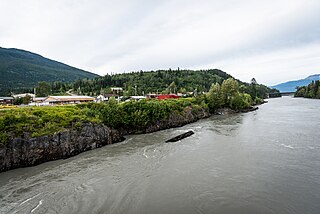
Lax̱g̱altsʼap is a Nisg̱a’a village of approximately 248, in the Nass River valley of British Columbia, Canada. It is one of the four main villages in the Nisg̱a’a Lisims, the formal name for their territory, and is situated on the north side of the Nass River between Gitwinksihlkw to the east and Ging̱olx to the west. It is approximately 24 km from where the Nass empties into the Pacific Ocean at Nass Bay. Road access is via the Nisga'a Highway.

West Redonda Island is an island in British Columbia, Canada. It is part of the Discovery Islands, an archipelago between Vancouver Island and the mainland, and between the Strait of Georgia and Johnstone Strait.

The Ksi Sii Aks is a tributary of the Nass River in northwestern British Columbia, Canada. It is most notable as the namesake of Tseax Cone, a volcano within its basin that was responsible for an eruption in the 17th century that killed 2,000 Nisgaʼa people. Prior to the eruption, the Nisgaʼa name for this river was Ksi Gimwitsʼax. Buried by the eruption, it eventually resurfaced. The Nisgaʼa recognized it as the same stream but renamed it Ksi Sii Aks: sii aks means "new body of water".

Gitwinksihlkw formerly Canyon City, is a Nisga'a Village in the Nass River valley of northwestern British Columbia, Canada, near that river's confluence with the Tseax River. An older spelling is Kitwilluchsilt. It is one of four Nisga'a villages. Road access is via the Nisga'a Highway.
The Kitwanga River is a tributary of the Skeena River near Hazelton in northwestern British Columbia, Canada, joining that stream at the community of Kitwanga (Gitwangak), which means "people of the place of rabbits".
The McGregor River is a tributary of the Fraser River in the Canadian province of British Columbia.
The Inklin River is a tributary of the Taku River in the northwest part of the province of British Columbia, Canada. It originates at the confluence of its two main tributaries, the Nahlin River and the Sheslay River and flows generally west and northwest about 83 km (52 mi) to join the Nakina River. The confluence of the Inklin and Nakina Rivers, at the uninhabited locality of Inklin, marks the beginning of the Taku River. The mouth of the Inklin River is located about 100 km (62 mi) northeast of Juneau, Alaska and about 160 km (99 mi) northwest of Telegraph Creek, British Columbia.

The Tahltan River is a tributary of the Stikine River in northwest part of the province of British Columbia, Canada. It flows generally east and southeast about 95 km (59 mi) to join the Stikine River at Tahltan, British Columbia. The lower Tahltan River marks the boundary between the Tahltan Highland and the Nahlin Plateau, both of which are part of the larger Stikine Plateau region.
The Wannock River is a short river in the Central Coast region of British Columbia, Canada, draining Owikeno Lake and entering Rivers Inlet at the head of that inlet, adjacent to the town of the same name, which is the main modern settlement of the Wuikinuxv (Owikeno) people. Katit Indian Reserve No. 1 is located around the banks of the river, including Katit Island, which is an island in the river.
The Stawamus River is a small, creek-like river in British Columbia. It enters the Howe Sound east of the mouth of the Squamish River.
The Twin River is a tributary of the Iskut River in the northwest part of the province of British Columbia, Canada. From its source in Twin Glacier the Twin River flows south for about 11 km (6.8 mi), east of Hoodoo Mountain to the Iskut River north of the Craig River watershed. The Twin River's watershed covers 203 km2 (78 sq mi), and its mean annual discharge is an estimated 16.7 m3/s (590 cu ft/s). The river's watershed's land cover is classified as 77.2% snow/glacier, 9.8% barren, 4.5% conifer forest, and small amounts of other cover.
The Little Tuya River is a tributary of the Tuya River in northwest part of the province of British Columbia, Canada. It flows generally south and east about 71 km (44 mi) to join the Tuya River near Cariboo Meadows. The Little Tuya River's watershed covers 569 km2 (220 sq mi), and its mean annual discharge is an estimated 6.69 m3/s (236 cu ft/s).
The Chilako River is a tributary of the Nechako River, one of the main tributaries of the Fraser River, in the Canadian province of British Columbia. It flows through the Nechako Plateau.
The Khtada River is a tributary of the Skeena River in the North Coast Regional District of the province of British Columbia, Canada. It originates in the Kitimat Ranges of the Coast Mountains, and flows south about 26 km (16 mi) to the lower tidal reach of the Skeena River, about 24 km (15 mi) upriver from Port Essington, 48 km (30 mi) southeast of Prince Rupert, and about 74 km (46 mi) southwest of Terrace.
The Koshin River is a tributary of the Nahlin River in northwest part of the province of British Columbia, Canada. It flows generally north about 58 km (36 mi) to join the Nahlin River, which forms the Inklin River, one of the main tributaries of the Taku River. The Koshin River flows through the Nahlin Plateau. It joins the Nahlin River at the boundary between the Nahlin and Kawdy plateaus. Both plateaus are part of the larger Stikine Plateau region.
The Inhini River is a tributary of the Iskut River in the northwest part of the province of British Columbia, Canada, in Cassiar Land District. From its source in the glaciers of Simma Mountain and Mount Rastus, the Inhini River flows north for about 25 km (16 mi) to the Iskut River just east of the Iskut's confluence with the Stikine River.