Castle Towers Mountain

Last updated
Castle Towers Mountain
Castle Towers Mountain.jpg
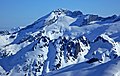
Castle Towers Mountain seen from Gentian Ridge
Highest point
Elevation 2,676 m (8,780 ft) [1]
Prominence 1,103 m (3,619 ft) [1]
Coordinates 49°56′23″N122°56′33″W / 49.93972°N 122.94250°W / 49.93972; -122.94250 [2]
Geography
Canada British Columbia relief location map.jpg
Red triangle with thick white border.svg
Castle Towers Mountain
Location of Castle Towers Mountain in SW B.C.
Location British Columbia, Canada
District New Westminster Land District
Parent range Pacific Ranges
Topo map NTS 92G15 Mamquam Mountain
Climbing
First ascent 1911 T. Park; H. Korten [1]

Castle Towers Mountain is a triple summit mountain on the east side of Garibaldi Lake in southwestern British Columbia, Canada. [1] The first ascent party from the BC Mountaineering Club named the mountain after its appearance in August 1911. [2]

Contents

Climate

Based on the Köppen climate classification, the mountain is located in the marine west coast climate zone of western North America. [3] Most weather fronts originate in the Pacific Ocean, and travel east toward the Coast Mountains where they are forced upward by the range (Orographic lift), causing them to drop their moisture in the form of rain or snowfall. As a result, the Coast Mountains experience high precipitation, especially during the winter months in the form of snowfall. Temperatures can drop below −20 °C with wind chill factors below −30 °C.

See also

Related Research Articles

<span class="mw-page-title-main">Mount Munday</span>

Mount Munday is one of the principal summits of the Pacific Ranges of the Coast Mountains in British Columbia, Canada. It is 3,356 m (11,010 ft) in elevation and stands in the Waddington Range six kilometres southeast of Mount Waddington 4,019 m (13,186 ft), which is the highest summit in the Coast Mountains.

<span class="mw-page-title-main">Glacier Pikes</span> Mountain in British Columbia, Canada

Glacier Pikes is a lava dome, located in the Garibaldi Lake volcanic field, British Columbia, Canada. The dome has two rocky points at the southern end of the Sentinel Glacier Neve. It is located within Garibaldi Provincial Park and is part of the Garibaldi Ranges of the Coast Mountains. The mountain's toponym was officially adopted on May 3, 1951, by the Geographical Names Board of Canada.

<span class="mw-page-title-main">Blackcomb Peak</span> Mountain in British Columbia, Canada

Blackcomb Peak is a mountain located east of Whistler, British Columbia that forms the boundary between the Whistler Blackcomb ski resort and Garibaldi Provincial Park. Like Whistler Mountain, it is located on the edge of Garibaldi Provincial Park and the ski lifts are often used to access the park, particularly for the Spearhead Traverse.

<span class="mw-page-title-main">The Sphinx (British Columbia)</span>

The Sphinx is a mountain in the southernmost Coast Mountains of British Columbia, Canada. It is southeast of Garibaldi Lake.

<span class="mw-page-title-main">The Spearhead</span>

The Spearhead is a 2,457 m (8,061 ft) peak in the Garibaldi Ranges of British Columbia, Canada, and is one of the main summits of the Blackcomb Mountain portion of the Whistler Blackcomb ski resort, located at the apex of the Blackcomb and Spearhead Glaciers, which is named for it. It also is the namesake of the Spearhead Range, which is the short range flanking the north side of Fitzsimmons Creek and ending on its northwest end at Blackcomb Mountain. The mountain's name was officially adopted on August 27, 1965, by the Geographical Names Board of Canada.

<span class="mw-page-title-main">Mamquam Mountain</span>

Mamquam Mountain is a mountain in the Pacific Ranges of the Coast Mountains in southwestern British Columbia, Canada, located 6 km (3.7 mi) southeast of Eanastick Meadows and 22 km (14 mi) east of Brackendale. It represents the highest summit of the Mamquam Icefield and lies at the southern end of Garibaldi Provincial Park. Mamquam Mountain was named on September 2, 1930, in association with the Mamquam River.

<span class="mw-page-title-main">Fissile Peak</span>

Fissile Peak, formerly known as Red Mountain, is a mountain peak located on the eastern side of Cheakamus Lake southeast of Whistler in Garibaldi Provincial Park of British Columbia, Canada. The mountain is composed of red slate which is easily divided into thin sheets of uniform thickness; in geological terms this feature is known as fissility.

<span class="mw-page-title-main">Overlord Mountain</span> Mountain in the country of Canada

Overlord Mountain is a 2,625-metre (8,612-foot) glacier-clad peak located in the Garibaldi Ranges of the Coast Mountains, in Garibaldi Provincial Park of southwestern British Columbia, Canada. It is the highest point of the Fitzsimmons Range, which is a subset of the Garibaldi Ranges, and can be readily seen from the Whistler Blackcomb ski area. It is situated 15 km (9 mi) southeast of Whistler, and its nearest higher peak is Mount Macbeth, 3 km (2 mi) to the north-northeast. The Benvolio Glacier rests below the south aspect of the summit, the Fitzsimmons Glacier on the east aspect, and the expansive Overlord Glacier spans the northern and western aspects of the mountain. Precipitation runoff from the peak and meltwater from its glaciers drains into tributaries of the Cheakamus River. The first ascent of the mountain was made in 1923 by Phyllis Munday and Don Munday via the Benvolio Glacier. The mountain's descriptive name was recommended by the Garibaldi Park Board and officially adopted on September 2, 1930, by the Geographical Names Board of Canada.

<span class="mw-page-title-main">Mount Davidson (British Columbia)</span> Mountain in the country of Canada

Mount Davidson is a 2,516-metre (8,255-foot) mountain summit located in the Garibaldi Ranges of the Coast Mountains, in Garibaldi Provincial Park of southwestern British Columbia, Canada. Visible from the Whistler Blackcomb ski area, it is situated 18 km (11 mi) south of Whistler, and its nearest higher peak is Castle Towers Mountain, 3 km (2 mi) to the west. The Cheakamus Glacier lies between these two summits, and precipitation runoff from the peak and meltwater from the glacier drains into tributaries of the Cheakamus River. The first ascent of the mountain was made in 1929 by Neal M. Carter and Emmy Milledge. The mountain is named after Professor John Davidson, who contributed a large amount of botanical knowledge about Garibaldi Park. The mountain's name was officially adopted on September 2, 1930, by the Geographical Names Board of Canada.

<span class="mw-page-title-main">Mount Benvolio</span> Mountain in the country of Canada

Mount Benvolio is a 2,613-metre (8,573-foot) glacier-clad peak located in the Garibaldi Ranges of the Coast Mountains, in Garibaldi Provincial Park of southwestern British Columbia, Canada. It is the second-highest point of the Fitzsimmons Range, which is a subset of the Garibaldi Ranges. It is situated 15 km (9 mi) southeast of Whistler, and its nearest higher peak is Overlord Mountain, 0.7 km (0 mi) to the northwest. The Benvolio Glacier is set on the western slope of the peak, the Diavolo Glacier spreads out below the eastern aspect of the summit, and the Fitzsimmons Glacier descends the north slope. Precipitation runoff from the peak and meltwater from its glaciers drains into tributaries of the Cheakamus River.

<span class="mw-page-title-main">Panorama Ridge</span>

Panorama Ridge is a mountain ridge in the Garibaldi Ranges of the Pacific Ranges in southwestern British Columbia, Canada. It is located on the north side of Garibaldi Lake in Garibaldi Provincial Park.

<span class="mw-page-title-main">Mount Carr</span> Mountain in the country of Canada

Mount Carr is a 2,590-metre (8,497-foot) mountain summit located in British Columbia, Canada.

<span class="mw-page-title-main">Spire Peaks</span> Mountain in the country of Canada

Spire Peaks is a 2,279-metre (7,477-foot) mountain located in British Columbia, Canada.

<span class="mw-page-title-main">Isosceles Peak</span> Mountain in the country of Canada

Isosceles Peak is a 2,488-metre (8,163-foot) mountain summit located in British Columbia, Canada.

<span class="mw-page-title-main">Phyllis's Engine</span> Mountain in the country of Canada

Phyllis's Engine is a 2,517-metre (8,258-foot) granite pinnacle located in British Columbia, Canada.

<span class="mw-page-title-main">Guard Mountain</span> Mountain in the country of Canada

Guard Mountain is a 2,177-metre (7,142-foot) summit in British Columbia, Canada.

<span class="mw-page-title-main">Parapet Peak (Garibaldi Provincial Park)</span> Mountain in the country of Canada

Parapet Peak is a 2,463-metre (8,081-foot) mountain summit located in British Columbia, Canada.

<span class="mw-page-title-main">Gentian Peak</span> Mountain in the country of Canada

Gentian Peak is a 2,197-metre (7,208-foot) summit in British Columbia, Canada.

<span class="mw-page-title-main">Corrie Peak</span> Mountain in British Columbia, Canada

Corrie Peak is a 2,263-metre (7,425-foot) summit in British Columbia, Canada.

<span class="mw-page-title-main">Deception Peak</span> Mountain in the country of Canada

Deception Peak is a 2,233-metre (7,326-foot) summit in British Columbia, Canada.

References

  1. 1 2 3 4 "Castle Towers Mountain". Bivouac.com. Retrieved 2008-04-30.
  2. 1 2 "Castle Towers Mountain". BC Geographical Names . Retrieved 2009-01-13.
  3. Peel, M. C.; Finlayson, B. L. & McMahon, T. A. (2007). "Updated world map of the Köppen−Geiger climate classification". Hydrol. Earth Syst. Sci. 11. ISSN   1027-5606.