Mount Carr

Last updated
Mount Carr
Mount Carr.jpg
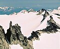
West aspect, from Garibaldi Lake
Highest point
Elevation 2,590 m (8,497 ft) [1] [2]
Prominence 133 m (436 ft) [1]
Parent peak Castle Towers Mountain [2]
Isolation 1.61 km (1.00 mi) [2]
Listing Mountains of British Columbia
Coordinates 49°55′27″N122°55′52″W / 49.92417°N 122.93111°W / 49.92417; -122.93111 [3]
Naming
Etymology Pvt. Frank Edward Carr
Geography
Canada British Columbia relief location map.jpg
Red triangle with thick white border.svg
Mount Carr
Location in British Columbia
Canada relief map 2.svg
Red triangle with thick white border.svg
Mount Carr
Mount Carr (Canada)
Country Canada
Province British Columbia
District New Westminster Land District
Protected area Garibaldi Provincial Park
Parent range Garibaldi Ranges
Coast Mountains
Topo map NTS 92G15 Mamquam Mountain [3]
Climbing
First ascent 1911
Easiest route via Sphinx Glacier [4]

Mount Carr is a 2,590-metre (8,497-foot) mountain summit located in British Columbia, Canada.

Contents

Description

Mount Carr is set within Garibaldi Provincial Park and is part of the Garibaldi Ranges of the Coast Mountains. [1] It is situated 70 km (43 mi) north of Vancouver and 2 km (1 mi) south-southeast of line parent Castle Towers Mountain. [1] Precipitation runoff and glacial meltwater from the west side of the peak drains to Garibaldi Lake, and the eastern slope drains to Cheakamus Lake. Topographic relief is significant as the summit rises 1,440 meters (4,724 feet) above Isosceles Creek in 4 kilometers (2.5 miles).

History

The peak is named after Frank Edward Carr (1886–1915), Vancouver post office clerk and British Columbia Mountaineering Club executive member, who served with the 7th Battalion, Canadian Expeditionary Forces, in Canada, England and France during World War I. [5] He was killed in action April 26, 1915, in France and is commemorated at the Menin Gate Memorial to the Missing in Belgium. [6] The toponym was officially adopted September 2, 1930, by the Geographical Names Board of Canada. [3]

The first ascent of Mt. Carr, which at the time was known as Copper Peak, was made in 1911 by a large BC Mountaineering Club party including Don Munday. [4] [7]

Climate

Based on the Köppen climate classification, Mount Carr is located in the marine west coast climate zone of western North America. [8] Most weather fronts originate in the Pacific Ocean, and travel east toward the Coast Mountains where they are forced upward by the range (Orographic lift), causing them to drop their moisture in the form of rain or snowfall. As a result, the Coast Mountains experience high precipitation, especially during the winter months in the form of snowfall. Winter temperatures can drop below −20 °C with wind chill factors below −30 °C. This climate supports the Sphinx Glacier on the west slope, Gray Glacier on the east, and the Cheakamus Glacier on the north slope.

See also

Related Research Articles

<span class="mw-page-title-main">Mount Waddington</span> Mountain in British Columbia, Canada

Mount Waddington, once known as Mystery Mountain, is the highest peak in the Coast Mountains of British Columbia, Canada. Although it is lower than Mount Fairweather and Mount Quincy Adams, which straddle the United States border between Alaska and British Columbia, Mount Waddington is the highest peak that lies entirely within British Columbia. It and the subrange which surround it, known as the Waddington Range, stand at the heart of the Pacific Ranges, a remote and extremely rugged set of mountains and river valleys.

<span class="mw-page-title-main">Mount Garibaldi</span> Stratovolcano in British Columbia, Canada

Mount Garibaldi is a dormant stratovolcano in the Garibaldi Ranges of the Pacific Ranges in southwestern British Columbia, Canada. It has a maximum elevation of 2,678 metres and rises above the surrounding landscape on the east side of the Cheakamus River in New Westminster Land District. Mount Garibaldi contains three summits, two of which are individually named. Atwell Peak is a sharp, conical summit slightly higher than the more rounded summit of Dalton Dome. Both summits were volcanically active at different times throughout Mount Garibaldi's eruptive history. The northern and eastern flanks of Mount Garibaldi are obscured by the Garibaldi Névé, a large snowfield containing several radiating glaciers. Flowing from the steep western face of Mount Garibaldi is the Cheekye River, a tributary of the Cheakamus River. Opal Cone on the southeastern flank is a small volcanic cone from which a lengthy lava flow descends. The western face is a landslide feature that formed in a series of collapses between 12,800 and 11,500 years ago. These collapses resulted in the formation of a large debris flow deposit that fans out into the Squamish Valley.

<span class="mw-page-title-main">Mount Munday</span>

Mount Munday is one of the principal summits of the Pacific Ranges of the Coast Mountains in British Columbia, Canada. It is 3,356 m (11,010 ft) in elevation and stands in the Waddington Range six kilometres southeast of Mount Waddington 4,019 m (13,186 ft), which is the highest summit in the Coast Mountains.

<span class="mw-page-title-main">Wedge Mountain</span> Mountain in British Columbia, Canada

Wedge Mountain, 2,895 m (9,498 ft) prominence: 2,249 m (7,379 ft), often locally referred to as The Wedge or simply "Wedge", is the highest summit in the Garibaldi Ranges and therefore also Garibaldi Provincial Park, and is among the nearest of the many peaks visible from the Whistler Blackcomb Ski Area, lying north across the valley of Billygoat Pass from the Spearhead Range, which includes one of that resort's two flagship mountains, Blackcomb. It was named for its distinctive wedge shape by the Garibaldi Park Board in 1932 in preference to Mount Vancouver, which had been submitted earlier. It is part of an unnamed range forming the most northerly group of peaks in the Garibaldi Ranges, the other two most notable being Mount Weart, known as the Armchair because of its shape, and Mount Currie, which overlooks the First Nations Reserve of the same name and the neighbouring town of Pemberton. Wedge's very high prominence is defined by the divide between the Green and Cheakamus Rivers at a locality at the south end of Alta Lake known as Tokum Corners.

<span class="mw-page-title-main">Castle Towers Mountain</span> Triple summit mountain in the country of Canada

Castle Towers Mountain is a triple summit mountain on the east side of Garibaldi Lake in southwestern British Columbia, Canada. The first ascent party from the BC Mountaineering Club named the mountain after its appearance in August 1911.

<span class="mw-page-title-main">Overlord Mountain</span> Mountain in the country of Canada

Overlord Mountain is a 2,625-metre (8,612-foot) glacier-clad peak located in the Garibaldi Ranges of the Coast Mountains, in Garibaldi Provincial Park of southwestern British Columbia, Canada. It is the highest point of the Fitzsimmons Range, which is a subset of the Garibaldi Ranges, and can be readily seen from the Whistler Blackcomb ski area. It is situated 15 km (9 mi) southeast of Whistler, and its nearest higher peak is Mount Macbeth, 3 km (2 mi) to the north-northeast. The Benvolio Glacier rests below the south aspect of the summit, the Fitzsimmons Glacier on the east aspect, and the expansive Overlord Glacier spans the northern and western aspects of the mountain. Precipitation runoff from the peak and meltwater from its glaciers drains into tributaries of the Cheakamus River. The first ascent of the mountain was made in 1923 by Phyllis Munday and Don Munday via the Benvolio Glacier. The mountain's descriptive name was recommended by the Garibaldi Park Board and officially adopted on September 2, 1930, by the Geographical Names Board of Canada.

<span class="mw-page-title-main">Mount Fitzsimmons (British Columbia)</span> Mountain in the country of Canada

Mount Fitzsimmons is a 2,603-metre (8,540-foot) glacier-clad peak located in the Garibaldi Ranges of the Coast Mountains, in Garibaldi Provincial Park of southwestern British Columbia, Canada. It is the third-highest point of the Fitzsimmons Range, which is a subset of the Garibaldi Ranges. It is situated 15 km (9 mi) southeast of Whistler, and its nearest higher peak is Mount Benvolio, 0.5 km (0 mi) to the west-southwest. The Diavolo Glacier spreads out below the southeast aspect of the summit, and the Fitzsimmons Glacier descends the northwest slopes. Precipitation runoff from the peak and meltwater from its glaciers drains into tributaries of the Cheakamus River. The first ascent of the mountain was made on August 19, 1924, by a party of the British Columbia Mountaineering Club. The peak was named for prospector James Fitzsimmons, who built a trail along Fitzsimmons Creek in an effort to haul supplies to a small copper mine he staked and worked. The mountain's name was officially adopted on September 2, 1930, by the Geographical Names Board of Canada.

<span class="mw-page-title-main">Mount Macbeth</span> Mountain in British Columbia, Canada

Mount Macbeth is a 2,639-metre (8,658-foot) glacier-clad peak located in the Garibaldi Ranges of the Coast Mountains, in Garibaldi Provincial Park of southwestern British Columbia, Canada. It is part of the Spearhead Range, which is a subset of the Garibaldi Ranges. It is situated 14 km (9 mi) southeast of Whistler, and 2 km (1 mi) south of Tremor Mountain, which is the highest point in the Spearhead Range. The Naden Glacier spreads out below the eastern aspect of the summit, the Macbeth Glacier lies below the south aspect, and the Curtain Glacier descends the northern slope. Precipitation runoff from the peak and meltwater from its glaciers drains into Fitzsimmons Creek which is a tributary of the Cheakamus River. Macbeth is most often climbed as part of the Spearhead Traverse. The first ascent of the mountain was made in 1969 by P. Starr, E. Bass, B. Ellis, and P. Macec via the northeast ridge. The peak was named in 1964 by an Alpine Club of Canada climbing party, to commemorate the 400th anniversary of William Shakespeare's birth. The mountain's name was officially adopted on August 27, 1965, by the Geographical Names Board of Canada.

<span class="mw-page-title-main">Mount Davidson (British Columbia)</span>

Mount Davidson is a 2,516-metre (8,255-foot) mountain summit located in the Garibaldi Ranges of the Coast Mountains, in Garibaldi Provincial Park of southwestern British Columbia, Canada. Visible from the Whistler Blackcomb ski area, it is situated 18 km (11 mi) south of Whistler, and its nearest higher peak is Castle Towers Mountain, 3 km (2 mi) to the west. The Cheakamus Glacier lies between these two summits, and precipitation runoff from the peak and meltwater from the glacier drains into tributaries of the Cheakamus River. The first ascent of the mountain was made in 1929 by Neal M. Carter and Emmy Milledge. The mountain is named after Professor John Davidson, who contributed a large amount of botanical knowledge about Garibaldi Park. The mountain's name was officially adopted on September 2, 1930, by the Geographical Names Board of Canada.

<span class="mw-page-title-main">Mount Benvolio</span> Mountain in the country of Canada

Mount Benvolio is a 2,613-metre (8,573-foot) glacier-clad peak located in the Garibaldi Ranges of the Coast Mountains, in Garibaldi Provincial Park of southwestern British Columbia, Canada. It is the second-highest point of the Fitzsimmons Range, which is a subset of the Garibaldi Ranges. It is situated 15 km (9 mi) southeast of Whistler, and its nearest higher peak is Overlord Mountain, 0.7 km (0 mi) to the northwest. The Benvolio Glacier is set on the western slope of the peak, the Diavolo Glacier spreads out below the eastern aspect of the summit, and the Fitzsimmons Glacier descends the north slope. Precipitation runoff from the peak and meltwater from its glaciers drains into tributaries of the Cheakamus River.

<span class="mw-page-title-main">Baby Munday Peak</span>

Baby Munday Peak is a 2,250-meter-elevation (7,382-foot) mountain summit located in the Cheam Range of British Columbia, Canada.

<span class="mw-page-title-main">Mount Trorey</span> Mountain in the country of Canada

Mount Trorey is a 2,461-metre (8,074-foot) mountain summit located in British Columbia, Canada.

<span class="mw-page-title-main">Spire Peaks</span>

Spire Peaks is a 2,279-metre (7,477-foot) mountain located in British Columbia, Canada.

<span class="mw-page-title-main">Isosceles Peak</span> Mountain in the country of Canada

Isosceles Peak is a 2,488-metre (8,163-foot) mountain summit located in British Columbia, Canada.

<span class="mw-page-title-main">Phyllis's Engine</span> Mountain in the country of Canada

Phyllis's Engine is a 2,517-metre (8,258-foot) granite pinnacle located in British Columbia, Canada.

<span class="mw-page-title-main">Guard Mountain</span>

Guard Mountain is a 2,177-metre (7,142-foot) summit in British Columbia, Canada.

<span class="mw-page-title-main">Parapet Peak (Garibaldi Provincial Park)</span>

Parapet Peak is a 2,463-metre (8,081-foot) mountain summit located in British Columbia, Canada.

<span class="mw-page-title-main">Gentian Peak</span> Mountain in the country of Canada

Gentian Peak is a 2,197-metre (7,208-foot) summit in British Columbia, Canada.

<span class="mw-page-title-main">Corrie Peak</span> Mountain in the country of Canada

Corrie Peak is a 2,263-metre (7,425-foot) summit in British Columbia, Canada.

<span class="mw-page-title-main">Deception Peak</span> Mountain in the country of Canada

Deception Peak is a 2,233-metre (7,326-foot) summit in British Columbia, Canada.

References

  1. 1 2 3 4 "Mount Carr, British Columbia". Peakbagger.com. Retrieved 2023-01-06.
  2. 1 2 3 "Mount Carr, Peakvisor.com" . Retrieved 2023-01-06.
  3. 1 2 3 "Mount Carr". Geographical Names Data Base . Natural Resources Canada . Retrieved 2023-01-06.
  4. 1 2 Dick Culbert (1969), A Climber's Guide to the Coastal Ranges of British Columbia, Alpine Club of Canada, p. 136
  5. "Mount Carr". BC Geographical Names . Retrieved 2023-01-06.
  6. Private Frank Edward Carr, veterans.gc.ca
  7. Kathryn Bridge (2006), A Passion for Mountains: The Lives of Don and Phyllis Munday, Rocky Mountain Books, ISBN   9781894765695, p. 224
  8. Peel, M. C.; Finlayson, B. L.; McMahon, T. A. (2007). "Updated world map of the Köppen−Geiger climate classification". Hydrol. Earth Syst. Sci. 11. ISSN   1027-5606.