
The Squamish-Lillooet Regional District is a quasi-municipal administrative area in British Columbia, Canada. It stretches from Britannia Beach in the south to Pavilion in the north. Lillooet, Pemberton, Whistler and Squamish are the four municipalities in the regional district. Its administrative offices are in the Village of Pemberton, although the district municipalities of Squamish and Whistler are larger population centres. The district covers 16,353.68 km2 of land area.
Concepción Huista is a town and municipality in the Guatemalan department of Huehuetenango.

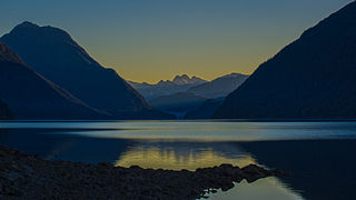
Birkenhead Lake Provincial Park is a provincial park in British Columbia, Canada, located in the Lillooet Country region. The park lies north of the communities of Squamish, Whistler and Pemberton, and immediately northwest of Birkenhead Peak and Gates Lake at the community of Birken.
Bishop River Provincial Park is a provincial park in the Pacific Ranges of the Coast Mountains on the Mainland of British Columbia, Canada, located southwest of and adjoining Ts'yl-os Provincial Park."Bishop River Park". BC Geographical Names. It lies along the upper course of the Bishop River, the main tributary of the Southgate River, from the Bishop's source at the western side of the Lillooet Icecap to midway along its course above its confluence with the Southgate. The park is 19,947 ha. in size. There are no roads or trails in the park although a forest service road from Waddington Harbour at the head of Bute Inlet leads up the Southgate to within a few miles of the park boundary.
Clendinning Provincial Park is a provincial park in British Columbia, Canada. It surrounds the drainage of Clendinning Creek, which is a tributary of the Elaho River. Its name is shared by the Clendinning Range, of which Mount Clendinning is the highest summit.
Princess Louisa Marine Provincial Park is a provincial park in British Columbia, Canada surrounding Princess Louisa Inlet.

The Spruce Lake Protected Area, formerly known variously as the Southern Chilcotin Mountains Provincial Park, Southern Chilcotins, and also as South Chilcotin Provincial Park, is a 71,347-hectare Protected Area in the British Columbia provincial parks system, approximately 200 km north of Vancouver. The area had been the subject of an ongoing preservationist controversy since the 1930s. In 2007, its status as a provincial park was downgraded to protected area.
Stuart River Provincial Park is a provincial park in British Columbia, Canada. It is located in two sections north and northwest of Vanderhoof along the Stuart River southeast of Stuart Lake and the city of Fort St. James. The upper section is located at 54°13′20″N124°00′00″W and comprises c.7391 ha. while the lower, eastern section is centred at 54°03′00″N123°37′00″W and comprises c.3390 ha. and is within the Greater Prince George area. The upper site, which is located around the confluence of the Stuart and Nechako Rivers, includes the site of Chinlac, a Dakelh village whose inhabitants were massacred and enslaved by the Tsilhqot'in of Anahim Lake c. 1745.

Gold Bridge is an unincorporated community in the Bridge River Country of British Columbia, Canada. Although numbering only around 40 inhabitants, Gold Bridge is the service and supply centre for the upper basin of the Bridge River Valley, which includes recreation-residential areas at the Gun Lakes, Tyaughton Lake, Marshall Creek, and Bralorne; and the nearby ghost towns of Brexton and Pioneer Mine.
The Bridge River Cones, sometimes referred to as the Lillooet Cones and Salal Creek Cones, is the name given to a volcanic field located on the north flank of the upper Bridge River, about 40 km (25 mi) west of the town of Gold Bridge. The cones are in the lee of the Lillooet Icecap and sit astride a group of passes between the Bridge River, which flows W-E to their south, and the Lord River, which flows north to the Taseko Lakes in the Chilcotin District.

The Lil'wat First Nation, a.k.a. the Lil'wat Nation or the Mount Currie Indian Band, is a First Nation band government located in the southern Coast Mountains region of the Interior of the Canadian province of British Columbia. It is a member of the Lillooet Tribal Council, which is the largest grouping of band governments of the St'at'imc or Stl'atl'imx people. Other St'at'imc governments include the smaller In-SHUCK-ch Nation on the lower Lillooet River to the southwest, and the independent N'quatqua First Nation at the near end of Anderson Lake from Mount Currie, which is the main reserve of the Lil'wat First Nation, and also one of the largest Indian reserves by population in Canada.
The Lillooet Icecap, also called the Lillooet Icefield or the Lillooet Crown, is a large icefield in the Pacific Ranges of the Coast Mountains in southwestern British Columbia, Canada. It is about 90 km (56 mi) northwest of the towns of Pemberton and Whistler, and about 175 km (109 mi) north of Vancouver, British Columbia. The Lillooet Icecap is one of the largest of several large icefields in the Pacific Ranges which are the largest temperate-latitude glacial fields in the world. At its maximum extent including its glacial tongues it measures 30 km (19 mi) east to west and 20 km (12 mi) north to south; its central icefield area is approximately 15 km (9 mi) in diameter.
Railroad Pass, 1385 m (4544 ft), usually known locally as Railway Pass, is a mountain pass in the Pacific Ranges of the Coast Mountains in southwestern British Columbia, Canada. Traversed by a seasonal dirt road known as the Hurley Main and sometimes also referred to therefore as Hurley Pass, the pass connects the Pemberton Meadows area of the upper valley of the Lillooet River, via Railroad Creek, to the uppermost reaches of the Hurley River, the main south fork of the Bridge River which the Hurley joins at the settlement of Gold Bridge.

Meager Creek is a creek in the southern Pacific Ranges of the Coast Mountains in British Columbia, Canada. It flows northeast into the Lillooet River approximately 95 km (59 mi) northwest of the village of Pemberton and is adjacent to the Upper Lillooet Provincial Park.
Alouette Lake, originally Lillooet Lake and not to be confused with the lake of that name farther north, is a lake and reservoir in Maple Ridge, British Columbia, Canada. It is at the southeastern foot of the mountain group known as the Golden Ears and is about 16 km in length on a northeast–southwest axis. It, and the Alouette River, were renamed in 1914 to avoid confusion with the larger river and lake farther north, with "Alouette", the French word for "lark", being chosen as being melodious and reminiscent of the original name in tone.
Wedge Pass, also known as Billygoat Pass, 1430 m (4692 ft), is a mountain pass in the northern Garibaldi Ranges, the southwesternmost subdivisions of the Pacific Ranges of the Coast Mountains in British Columbia, Canada. Located immediately on the southern flank of Wedge Mountain and to the immediate north of the Spearhead Range, site of the Blackcomb half of the Whistler Blackcomb Ski Area, it connects the head of Wedge Creek (W), a tributary of the Green River with those of Billgoat Creek (E), a tributary of the Lillooet River. The pass is within Garibaldi Provincial Park and has no road access.
Bridge River Delta Provincial Park is a provincial park in British Columbia, Canada, located 65 kilometres (40 mi) north of Pemberton and 80 kilometres (50 mi) west of Lillooet. Established in 2010, the park covers 992 hectares.
Fred Antoine Provincial Park is a provincial park in British Columbia, Canada, 25 kilometres northwest of Lillooet, British Columbia. The park, which is 2,230 hectares in size, was established in 2010.
There are many lakes named Long Lake in British Columbia, Canada.
The Bishop River is a river in the Pacific Ranges of the Coast Mountains, flowing west from the western edge of the Lillooet Icecap to join the Southgate River east of the Homathko Icefield. Bishop River Provincial Park surrounds the upper course of the river, from the source at the Lillooet Icecap to midway along its course above its confluence with the Southgate.

