
Pacific Rim National Park Reserve is a 511 km2 (197 sq mi) national park located in British Columbia, Canada, which comprises three separate regions: Long Beach, the Broken Group Islands, and the West Coast Trail. It is located in the Pacific Coast Mountains, which are characterized by rugged coasts and temperate rainforests.
Englishman River is a river in the eastern side of Vancouver Island, British Columbia, Canada. It starts on the eastern slopes of the Beaufort Range, originating from tiny Jewel Lake and flowing in an easterly direction for 40 km (25 mi), entering the Strait of Georgia at Parksville, British Columbia. It is an important watershed providing habitat for various species of salmon and community water to the residents of Parksville and surrounding area. The Englishman River watershed includes Arrowsmith Lake, Hidden Lake, Fishtail Lake, Rowbotham Lake, Healy Lake, Shelton Lake, and Rhododendron Lake.

Adams Lake Provincial Park is a provincial park in British Columbia, Canada. It encompasses three distinct parks: Adams Lake Provincial Park, Adams Lake Marine Provincial Park, and Adams Lake Marine Provincial Park.
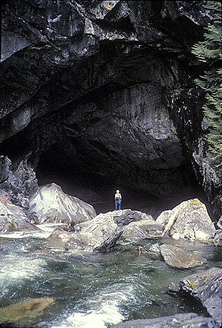
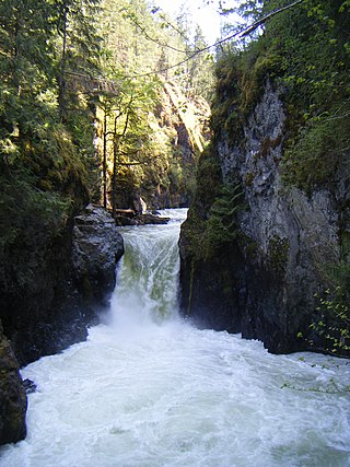
Artlish Caves Provincial Park is a provincial park on Vancouver Island in British Columbia, Canada.

Broughton Archipelago Provincial Park is the largest marine provincial park located in British Columbia, Canada. The park is located in the Queen Charlotte Strait around 30 kilometres (19 mi) east of Port McNeill, a town situated on Vancouver Island. In terms of its functions, the park offers tourism opportunities such as kayaking and whale watching, preserves a wide array of wildlife including many at-risk species, and has a long history of use by First Nation peoples.

Parts of this article have been adapted from the BC Parks website.

Carmanah Walbran Provincial Park, originally Carmanah Pacific Provincial Park, is a remote wilderness park located inside traditional Ditidaht First Nation ancestral territory. The park covers a land area of 16,450 ha (63.5 sq mi) immediately adjacent to Pacific Rim National Park Reserve's West Coast Trail on the south-western, coastal terrain of Vancouver Island. The provincial park comprises the entire drainage of Carmanah Creek, and a good portion of the lower Walbran River drainage, both of which independently empty into the Pacific Ocean. The park is named after the Anglicized diitiid?aatx word kwaabaaduw7aa7tx, or Carmanah, meaning "as far up as a canoe can go" and John Thomas Walbran, a colonial explorer and ship's captain. Access to the park is by gravel logging road from Port Alberni, Lake Cowichan, or Port Renfrew.

Golden Ears Provincial Park is a 555.9 square kilometres (214.6 sq mi) provincial park in British Columbia, Canada. It is named after the prominent twin peaks, which are commonly referred to as Golden Ears. The park was originally part of Garibaldi Provincial Park but was split off as a separate park in 1967. The area was logged extensively in the 1920s by the Lougheed and Abernathy Logging Company. Many recreational attractions are found within the park. Golden Ears Provincial Park is a protected area that contains many endangered species of flora and fauna.
Desolation Sound Marine Provincial Park is a provincial park in British Columbia, Canada located along Desolation Sound. The park is distinguished by its many picturesque sheltered coves and anchorages, frequented by yachts and pleasure craft. The scenery consists of waterfalls, rugged glaciated peaks, and steep forested slopes that fall into the ocean.
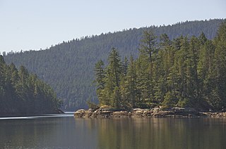
Nimpkish Lake Provincial Park is a provincial park on northern Vancouver Island, British Columbia, Canada on Vancouver Island. The park is 3,949 ha. in area and was established on 1995. It is 32 km south of Port McNeill and on the southwest side of Nimpkish Lake. Primary access is by boat launch, though radio-controlled logging roads lead to the edge of the park. Western Forest Products in Woss, British Columbia should be contacted for road advisories. The park is in the traditional territory of the Namgis First Nation.
Schoen Lake Provincial Park is a provincial park in northeastern Vancouver Island, British Columbia, Canada, located east of the community of Woss Lake and southwest of Sayward. The park lies inside the Nimpkish Valley watershed. On October 28, 1977, the "Class A" park was officially created to protect, exhibit and interpret an example of the natural features and processes of the Insular Mountains Natural Region. The park covers a total area of 8,775 hectares. Within those hectares of park land is a number of lakes, creeks and mountain ranges.
Spatsizi Plateau Wilderness Provincial Park is located in the northern portion of British Columbia, Canada, approximately 698, 659 hectares and encompasses the Spatsizi River and Gladys Lake Ecological Reserve. The park is a designated protected area that is intended for the conservation and research on caribou, grizzly bears, fish, and other wildlife species populations. Before the provincial park's establishment in 1975, the area was a historical hunting ground for local Indigenous communities like the Tahltan First Nations. It is the second largest provincial park in British Columbia.
Tweedsmuir South Provincial Park is a provincial park covering parts of the eastern Kitimat Ranges, northern Pacific Ranges, and the Rainbow Range in British Columbia, Canada. It was established on May 21, 1938 in the western interior of the province, to protect its important natural features. The park hosts a variety of recreation activities for visitors. This park encompasses a range of diverse species in this park including bears, moose, and various fish. There are also a few at risk species in this park.
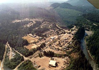
Woss, also commonly known as Woss Lake after the nearby lake of the same name, is a small village in the Nimpkish Valley, located 75 km (47 mi) southeast of Port McNeill and 128 km (80 mi) north of Campbell River on Highway 19, in northeastern Vancouver Island, British Columbia, Canada. The estimated population of Woss and the Nimpkish Valley is 200. The town of Woss lies about 3 km north of Woss Lake, a long, narrow lake stretching about 10 km in a primarily north–south direction with a maximum width of about one km, the southern portion of which is part of Woss Lake Provincial Park.
The Tuya River is a major tributary of the Stikine River in northwest part of the province of British Columbia, Canada. From its source at High Tuya Lake in Tuya Mountains Provincial Park just south of Ash Mountain, the highest peak of the Tuya Range, the Tuya River flows south about 200 km (120 mi) to meet the Stikine River in the Grand Canyon of the Stikine. The Tuya River's main tributary is the Little Tuya River. The Tuya River divides the Tanzilla Plateau on the east from the Kawdy Plateau, to the northwest, and the Nahlin Plateau, to the southwest. All three are considered sub-plateaus of the Stikine Plateau. The Tuya River's watershed covers 3,575 km2 (1,380 sq mi), and its mean annual discharge is estimated at 36.9 m3/s (1,300 cu ft/s). The mouth of the Tuya River is located about 24 km (15 mi) northeast of Telegraph Creek, British Columbia, about 67 km (42 mi) southwest of Dease Lake, British Columbia, and about 210 km (130 mi) east of Juneau, Alaska. The Tuya River's watershed's land cover is classified as 35.7% shrubland, 31.4% conifer forest, 14.0% mixed forest, 7.2% herbaceous, and small amounts of other cover.

South Chilcotin Mountains Provincial Park is a provincial park in British Columbia, Canada, located on Highway 40 northwest of Lillooet, British Columbia. The park, which is 56,796 ha. in size, was established on April 18, 2001, and It was created out of a portion of the Spruce Lake Protected Area. The park is located on three Indigenous Nations: The Tsilhqot’in, St’at’imc, and Secwepemc.
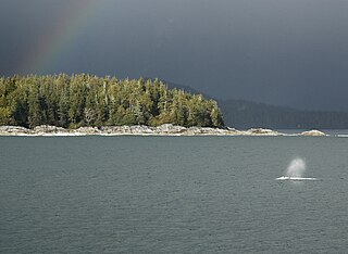
Clayoquot Sound Biosphere Reserve is a UNESCO Biosphere Reserve situated in Clayoquot Sound on the west coast of Vancouver Island in British Columbia, Canada. A diverse range of ecosystems exist within the biosphere reserve boundaries, including temperate coastal rainforest, ocean and rocky coastal shores.
The Gitnadoix River is a tributary of the Skeena River in the province of British Columbia, Canada. It originates in the Kitimat Ranges, and flows about 38 km (24 mi) north to the Skeena River, about 45 km (28 mi) west of Terrace.
The Dudidontu River is a tributary of the Nahlin River in northwest part of the province of British Columbia, Canada. It joins the Nahlin River, which forms the Inklin River, one of the main tributaries of the Taku River. The Dudidontu River's watershed covers 964 km2 (372 sq mi), and its mean annual discharge is 15.4 m3/s (540 cu ft/s). Almost half of the Dudidontu's flow comes from its main tributary, Kakuchuya Creek, and Kakuchuya Creek's main tributary, Matsatu Creek. The mouth of the Dudidontu River is located about 150 km (93 mi) northeast of Juneau, Alaska and about 110 km (68 mi) northwest of Telegraph Creek, British Columbia.
Scott Islands Marine National Wildlife Area is a National Wildlife Area off the northwestern tip of Vancouver Island in the Canadian province of British Columbia. Covering an area of 11,570.65 km2 (4,467.45 sq mi), it is the second largest protected area in British Columbia after Offshore Pacific Seamounts and Vents Closure and is the largest national wildlife area in Canada.


