
Keswick (/ˈkɛzˌwɪk/) is a community located in the Canadian province of Ontario. Situated in Cook's Bay on Lake Simcoe, 72 km (45 mi) north of Toronto. Keswick is part of the Town of Georgina, the northernmost municipality in the Regional Municipality of York. In the Canada 2016 Census, the municipal population of Keswick was 26,757.

Mount Robson Provincial Park is a provincial park in the Canadian Rockies with an area of 2,249 km2. The park is located entirely within British Columbia, bordering Jasper National Park in Alberta. The B.C. legislature created the park in 1913, the same year as the first ascent of Mount Robson by a party led by Conrad Kain. It is the second oldest park in the provincial system. The park is named for Mount Robson, which has the highest point in the Canadian Rockies and is located entirely within the park.

Georgina is a town in south-central Ontario. The northernmost municipality in the Regional Municipality of York, the town is bounded to the north by Lake Simcoe. Although incorporated as a town, it operates as a township in which dispersed communities share a common administrative council. The largest communities are Keswick, Sutton, and Jackson's Point. Smaller communities include Pefferlaw, Port Bolster, Roches Point, Udora, and Willow Beach. The town was formed by the merger of the Village of Sutton, the Township of Georgina, and the Township of North Gwillimbury in 1971 and incorporated in 1986. North Gwillimbury had been part of Georgina but became its own township in 1826. It took its name from the family of Elizabeth Simcoe, née Gwillim.

The Canadian is a transcontinental passenger train operated by Via Rail with service between Union Station in Toronto, Ontario, and Pacific Central Station in Vancouver, British Columbia, Canada.

Whiteshell Provincial Park is a provincial park in southeast Manitoba, approximately 120 kilometres (75 mi) east of the city of Winnipeg. The park is considered to be a Class II protected area under the IUCN protected area management categories. It is 275,210 hectares in size.
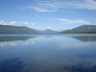
Blue Earth Lake Provincial Park is a provincial park in the Upper Hat Creek area at the south end of the Cornwall Hills, just northwest of Ashcroft, British Columbia, Canada.
Kootenay Lake Provincial Park is a provincial park in British Columbia, Canada. It encompasses five widely dispersed parks around Kootenay Lake: Kootenay Lake Provincial Park, Kootenay Lake Provincial Park, Kootenay Lake Provincial Park, Kootenay Lake Provincial Park, and Kootenay Lake Provincial Park.
Kinaskan Lake Provincial Park is a provincial park in British Columbia, Canada, located at the south end of Kinaskan Lake along the Stewart-Cassiar Highway near Mowdade Lake and southeast of Mount Edziza. At the south end of the park, the Iskut River, of which the lake is an expansion, spills over 12.2-metre Cascade Falls. The park is approximately 800 ha. in size.
Uncha Mountain Red Hills Provincial Park is a provincial park in British Columbia, Canada, comprising two parcels of land on the north and south shores of Francois Lake. Total area of the park is 9,421 hectares.
Wapiti Lake Provincial Park is a 16,837-hectare (41,610-acre) provincial park in British Columbia, Canada. It is 60 kilometres (37 mi) south of Tumbler Ridge, at the headwaters of Wapiti River, including its watershed from the Wapiti Pass to Wapiti Lake in the Canadian Rockies. The area contains significant amounts of fossils (ichthyosaurs) and fossil beds. There is habitat for grizzly bears, mountain goats, and bull trout. It was established as a Provincial Park on June 26, 2000. It is recognized by the provincial government as being an area traditionally used by First Nations people. Hunting and fishing are permitted in the park.

Ross Lake Provincial Park is a provincial park in British Columbia, Canada. The park is located within the asserted traditional territory of the Gitxsan people, south of Nine Mile Mountain, just east of Hazelton in the Skeena Country.
Tweedsmuir North Provincial Park and Protected Area is a provincial park in British Columbia, Canada, which along with Tweedsmuir South Provincial Park and Entiako Provincial Park were once part of Tweedsmuir Provincial Park, then B. C.'s largest park, 9,810 square kilometres (3,790 sq mi) located in the Coast Range.
Sibbald Point Provincial Park is a provincial park located in Sutton West, Ontario, Canada on the southern shores of Lake Simcoe, 70 kilometres (43 mi) north of Toronto. The park is located to the east of the vacation town of Jackson's Point, and The Briars Resort and Country Club which was still owned by the Sibbald family until it was sold in 2017.
Highway 38 is a provincial highway in the south-east portion of the Canadian province of Saskatchewan. It runs north from Kuroki to Chelan providing access to Greenwater Lake Provincial Park and Kelvington. Highway 38 is a primary highway that is paved in its entirety and maintained by the provincial government. It is approximately 89 kilometres (55 mi) long.

Highway 39 is a provincial paved highway in the southern portion of the Canadian province of Saskatchewan connecting North Portal and Moose Jaw in the north. This is a primary Saskatchewan highway maintained by the provincial and federal governments that provides a major trucking and tourism route between the United States at Portal, North Dakota and the Trans-Canada Highway near Moose Jaw.

Vaseux Lake is a shallow freshwater lake located along the course of the Okanagan River in the Okanagan Valley of British Columbia, Canada.
Two Lakes Provincial Park is a provincial park in Alberta, Canada, located 142 km (88 mi) south of Grande Prairie, 65 km (40 mi) south of Highway 666 and an additional 77 km (48 mi) south on forestry roads, where 4WD is recommended for access.
The Northern Rocky Mountains, usually referred to as the Northern Rockies, are a subdivision of the Canadian Rockies comprising the northern half of the Canadian segment of the Rocky Mountains. While their northward limit is easily defined as the Liard River, which is the northward terminus of the whole Rockies, the southward limit is debatable, although the area of Mount Ovington and Monkman Pass is mentioned in some sources, as south from there are the Continental Ranges, which are the main spine of the Rockies forming the boundary between British Columbia and Alberta. Some use the term to mean only the area north of the Peace Arm of the Williston Reservoir, and in reference to Northern Rocky Mountains Provincial Park, while others consider the term to extend all the way south, beyond the limit of the Hart Ranges at Mount Ovington, to include the McBride area, the Sir Alexander Group and Mount Robson.
Bridge Lake is a lake in the Interlakes District of the South Cariboo region of the Interior of British Columbia, Canada. It is the source of Bridge Creek which runs in a curving course west and then northeast to Canim Lake via the town of 100 Mile House. The lake is approximately 16 km2 in area (including the area of several islands and rocks in the lake, the largest of which is named Long Island and is 1136 m in elevation. It is located 560 km north of Vancouver and around 140 km northwest of Kamloops in the Interlakes District close to the Little Fort Highway. It and its neighbours Sheridan Lake and Lac des Roches are the largest lakes along the Interlakes Highway.
Roche Percee is a village in the Canadian province of Saskatchewan within the RM of Coalfields No. 4 and Census Division No. 1. The village is near the Canada–United States border, just off Highway 39. Roche Percee is about 20 kilometres (12 mi) east of Estevan in the Souris River valley.


