Arrow Lakes Provincial Park is a provincial park in British Columbia, Canada.
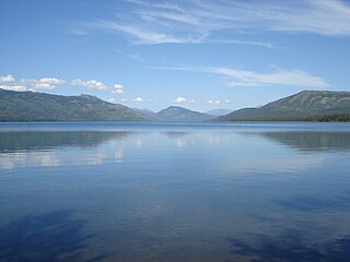
Atlin/Áa Tlein Téix'i Provincial Park is a provincial park in British Columbia, Canada. Situated in the remote northwestern corner of the province, the park protects large tracts of boreal forest, alpine tundra and glaciated terrain. The southern third of Atlin Lake, the largest natural body of freshwater in the province, is within the park boundary. The park is very undeveloped; no roads traverse it and no facilities, supplies, developed campsites or maintained hiking trails are available inside the park. The area has become a focal point in controversies involving proposed hydroelectric projects affecting Atlin Lake and environmental groups who view these proposals as potentially damaging to the lake's environment and its surroundings.
Christina Lake Provincial Park is a provincial park in British Columbia, Canada. The lake it's on, Christina Lake, is renowned as the warmest lake in Canada.
Duffey Lake Provincial Park is a provincial park in British Columbia, Canada, located at the lake of the same name, which lies along BC Highway 99 just east of the summit of Cayoosh Pass. The lake's inflow and outflow are Cayoosh Creek. The park's highest point is Mount Rohr at the westernmost boundary.
Ed Bird – Estella Lakes Provincial Park is a provincial park in British Columbia, Canada.
Edge Hills Provincial Park is a provincial park in British Columbia, Canada, located west of the town of Clinton. The Edge Hills flank the wall of the Fraser Canyon north of Moran Canyon and form a small fore-range between the river and the higher Marble Range just east. Access to the Edge Hills is via the Jesmond Road, which cuts north off the Pavilion Mountain Road at Kelly Lake. A spur road from the Jesmond Road west goes to an overlook atop the Edge Hills, known as Cougar Point.
Elk Lakes Provincial Park is a provincial park in southeastern British Columbia, Canada, located west of the continental divide. It is located adjacent to Height of the Rockies Provincial Park and is about 104 kilometers north of Sparwood. The park features sub-alpine landscapes, remnant glaciers, rugged peaks and productive lakes. Much of the park is above treeline and features several prominent mountains including Mount Fox, Mount Aosta, Mount McCuaig, and Mount Elkan. The Petain, Castelnau, Nivelle, and Elk Glaciers lie on the northeastern edge of the park. The following lakes are also present inside park boundaries: Upper and Lower Elk Lake, Frozen Lake, Fox Lake, Cadorna Lake, and Abruzzi Lake. Below the treeline, the park features mature growth forests of alpine fir, Engelmann spruce, and lodgepole pine. These trees are also intermingled with juniper, twinberry, false azalea, white rhododendron, and buffalo berry. The wildlife of the area includes Beaver, Snowshoe Hare, Red Squirrel, white-tailed deer, moose, and many varieties of birds.

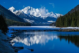
Hamber Provincial Park is a provincial park in British Columbia, Canada, located 130 kilometres (80.7 mi) north of Golden. Straddling the Great Divide on the provincial boundary with Alberta, the park is surrounded on three sides by Jasper National Park and protects the headwaters of the Wood River at Fortress Lake.
James Chabot Provincial Park is a provincial park in British Columbia, Canada. Formerly Athalmer Beach Provincial Park, it is located in Invermere at the northeast end of Windermere Lake in the Columbia Valley region of the East Kootenay. Windermere Lake Provincial Park is located at the lake's southwestern end.
Kootenay Lake Provincial Park is a provincial park in British Columbia, Canada. It encompasses five widely dispersed parks around Kootenay Lake: Kootenay Lake Provincial Park, Kootenay Lake Provincial Park, Kootenay Lake Provincial Park, Kootenay Lake Provincial Park, and Kootenay Lake Provincial Park.
Kinaskan Lake Provincial Park is a provincial park in British Columbia, Canada, located at the south end of Kinaskan Lake along the Stewart-Cassiar Highway near Mowdade Lake and southeast of Mount Edziza. At the south end of the park, the Iskut River, of which the lake is an expansion, spills over 12.2-metre Cascade Falls. The park is approximately 800 ha. in size.

Mara Provincial Park is a day-use provincial park in British Columbia, Canada, located on Mara Lake south of Sicamous. The park is open with services from May 1 to September 27. The gate is locked open during the off season.
Monte Lake Provincial Park is a provincial park in British Columbia, Canada, located on the east side of Monte Lake and to the south of the community of Monte Lake, British Columbia which is at the north end of the lake. About five hectares in size, it protects an area of Ponderosa pine and grasslands.
Nickel Plate Provincial Park is a provincial park in British Columbia, Canada. Formerly known as Clearwater Park, it is located in the Similkameen District at the northeast corner of Nickel Plate Lake. The park is also 29km northeast of Hedley near the Apex Ski Resort.
One Island Lake Provincial Park is a provincial park in British Columbia, Canada.
Wapiti Lake Provincial Park is a 16,837-hectare (41,610-acre) provincial park in British Columbia, Canada. It is 60 kilometres (37 mi) south of Tumbler Ridge, at the headwaters of Wapiti River, including its watershed from the Wapiti Pass to Wapiti Lake in the Canadian Rockies. The area contains significant amounts of fossils (ichthyosaurs) and fossil beds. There is habitat for grizzly bears, mountain goats, and bull trout. It was established as a Provincial Park on June 26, 2000. It is recognized by the provincial government as being an area traditionally used by First Nations people. Hunting and fishing are permitted in the park.

Ross Lake Provincial Park is a provincial park in British Columbia, Canada. The park is located within the asserted traditional territory of the Gitxsan people, south of Nine Mile Mountain, just east of Hazelton in the Skeena Country.
Spatsizi Plateau Wilderness Provincial Park is located in the northern portion of British Columbia, Canada, approximately 698, 659 hectares and encompasses the Spatsizi River and Gladys Lake Ecological Reserve. The park is a designated protected area that is intended for the conservation and research on caribou, grizzly bears, fish, and other wildlife species populations. Before the provincial park's establishment in 1975, the area was a historical hunting ground for local Indigenous communities like the Tahltan First Nations. It is the second largest provincial park in British Columbia.
Tweedsmuir North Provincial Park and Protected Area is a provincial park in British Columbia, Canada, which along with Tweedsmuir South Provincial Park and Entiako Provincial Park were once part of Tweedsmuir Provincial Park, then B. C.'s largest park, 9,810 square kilometres (3,790 sq mi) located in the Coast Range.

Rainbow/Q'iwentem Provincial Park is a provincial park in the Cariboo region of British Columbia. The park was established in 2013 and is 385 hectares in size, protecting the land between Sulphurous Lake and Deka Lake. While there are no developed trails in the park, routes used by locals exist connecting roads on the North Shore of Deka Lake to the North Shore of Sulphurous Lake. The park is accessible by road only from the southwest.

