
Bear Glacier Provincial Park is a provincial park in British Columbia, Canada. The park is 542 ha in size and was established, effective 11 May 2000, by the Nisga'a Treaty, Appendix G-3.
Beatton River Provincial Park is a provincial park in the Peace River Country of northeastern British Columbia, Canada.
Conkle Lake Provincial Park is a provincial park in British Columbia, Canada, west of the confluence of the Kettle and West Kettle Rivers. The park size is 587 hectares. Bird species that live in the area are the common loon, merganser, ruffed grouse, pileated woodpecker, black-capped chickadee, and ruby-crowned kinglet. Mammals that live in the area are bears, squirrels, raccoons, rodents, beavers, deer, rabbits, foxes, and moose.
Kekuli Bay Provincial Park, formerly Kalamalka West Provincial Park, is a provincial park in British Columbia, Canada, located on the west shore of Kalamalka Lake on BC Highway 97 south of Vernon. The lake is popular for waterskiing and boating, and the park includes a boat launch, as well as a campground with a view of the lake. The park was established in 1990. Its size is about 57 hectares.
Main Lake Provincial Park is a provincial park on Quadra Island in British Columbia, Canada. Established in 1996 as Main Lakes Chain Park and renamed and expanded in 1997, the park encompasses a large wilderness area of six lakes with many diverse animal, bird and plant species. Opportunities for visitor observation and outdoor recreation include wilderness camping, canoeing, kayaking and hiking. Main Lake, Village Bay Lake and Mine Lake are connected by narrow, shallow marshes. Clear Lake, Stramberg Lake and Little Main Lake are accessible by hiking or rough portage.
Upper Violet Creek Provincial Park is a provincial park in British Columbia, Canada.
Pennask Lake Provincial Park is a provincial park in British Columbia, Canada, located on the easternmost heights of the Thompson Plateau, 50 km (31 mi) to the northwest of the Okanagan town of Peachland.
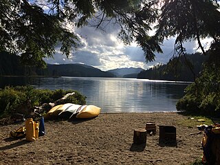
Princess Louisa Marine Provincial Park is a provincial park in British Columbia, Canada surrounding Princess Louisa Inlet.
Read Island Provincial Park is a provincial park in British Columbia, Canada. It is located on the south end of Read Island. Established in 1996, the park contains approximately 637 ha.
Rock Bay Marine Provincial Park is a provincial park in British Columbia, Canada, located on the Inside Passage at the junction of Johnstone Strait and Discovery Passage. The park contains approximately 525 ha. Rock Bay is located on the shore of Vancouver Island, immediately south of East Thurlow Island.
Small Inlet Marine Provincial Park is a provincial park in British Columbia, Canada on the northwest side of Quadra Island, near the city of Campbell River.
Stuart Lake Marine Provincial Park is a provincial park in British Columbia, Canada.
Tahsish-Kwois Provincial Park is a provincial park in British Columbia, Canada. Located west of Woss Lake, it is approximately 10,829 ha. in size.
Takla Lake Marine Provincial Park is a provincial park in British Columbia, Canada. Located northeast of the town of Smithers and roughly parallel to Babine Lake to its west/southwest, it comprises three sites on Takla Lake in the northwestern part of the Omineca Country of the province's North-Central Interior. The three sites are the Sandy Point Site, containing about 160 ha, Takla Lake West containing about 41 ha, and White Bluff, containing about 349 ha.
Thurston Bay Marine Provincial Park is a provincial park on the northwest side of Sonora Island in British Columbia, Canada.

The Gwa'sala-Nakwaxda'xw Nations are an amalgamation of two Kwakwaka'wakw peoples in a band government based on northern Vancouver Island in British Columbia, whose main reserve community is near the town of Port Hardy in the Queen Charlotte Strait region of the Central Coast region of British Columbia, Canada. In the 1960s the Gwa'sala (Gwaʼsa̱la), the 'Nakwaxda'xw (ʼNakʼwaxdaʼx̱w) and the Kwakiutl peoples were amalgamated. Later the Gwa'sala-'Nakwaxda'xw Nations and the Kwakiutl First Nation separated into the two groups that are recognized by the federal government. Gwa'sala-'Nakwaxda'xw Nations were forcibly relocated from their homelands to a location near Port Hardy.
The Rural Municipality of Park is a former rural municipality (RM) in the Canadian province of Manitoba. It was originally incorporated as a rural municipality on January 1, 1997. It ceased on January 1, 2015 as a result of its provincially mandated amalgamation with the RM of Harrison to form the Municipality of Harrison Park.

Read Island is an island in British Columbia, Canada. It is part of the Discovery Islands between Vancouver Island and the mainland, between the Strait of Georgia and Johnstone Strait.
Wedge Pass, also known as Billygoat Pass, 1430 m (4692 ft), is a mountain pass in the northern Garibaldi Ranges, the southwesternmost subdivisions of the Pacific Ranges of the Coast Mountains in British Columbia, Canada. Located immediately on the southern flank of Wedge Mountain and to the immediate north of the Spearhead Range, site of the Blackcomb half of the Whistler Blackcomb Ski Area, it connects the head of Wedge Creek (W), a tributary of the Green River with those of Billgoat Creek (E), a tributary of the Lillooet River. The pass is within Garibaldi Provincial Park and has no road access.
The Leq'á:mel First Nation, formerly known as Lakahahmen First Nation, is a First Nations band government whose community and offices are located in the area near Deroche, British Columbia in the Fraser Valley region in Canada, about 12 kilometres east of the District of Mission. They are a member government of the Sto:lo Nation Chiefs Council, which is one of two tribal councils of the Sto:lo.


