
The Red Deer River is a river in Alberta and a small portion of Saskatchewan, Canada. It is a major tributary of the South Saskatchewan River and is part of the larger Saskatchewan / Nelson system that empties into Hudson Bay.

Alice Lake Provincial Park is a provincial park in British Columbia, Canada.
Arrow Lakes Provincial Park is a provincial park in British Columbia, Canada.
Burns Lake Park is a provincial park in British Columbia, Canada, located near the town of Burns Lake. The park was established per Order in Council 63 on January 25, 2001, and constitutes approximately 65 hectares.
Bobtail Mountain Provincial Park is a provincial park in British Columbia, Canada. It was established on June 29, 2000, under the Protected Areas of British Columbia Act.
Chase Provincial Park is a provincial park in British Columbia, Canada, located around Carina and Tomias Lakes, 70 kilometres (43 mi) north of Germansen Landing in the Omineca Mountains and just west of the Finlay Arm of Williston Lake. Approximately 32,226 hectares (124.43 sq mi), it was established in 2001.
Ethel F. Wilson Memorial Provincial Park is a provincial park in central British Columbia, Canada. The park is situated on the northern tip of Pinkut Lake. Activities in the park include rainbow trout fishing and boating. The park has five campsites that are allocated on a first-come first-served basis. The area of the park is 33 hectares.
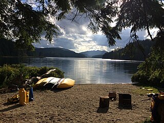
Ed Bird – Estella Lakes Provincial Park is a provincial park in British Columbia, Canada.
Edge Hills Provincial Park is a provincial park in British Columbia, Canada, located west of the town of Clinton. The Edge Hills flank the wall of the Fraser Canyon north of Moran Canyon and form a small fore-range between the river and the higher Marble Range just east. Access to the Edge Hills is via the Jesmond Road, which cuts north off the Pavilion Mountain Road at Kelly Lake. A spur road from the Jesmond Road west goes to an overlook atop the Edge Hills, known as Cougar Point.
Finger-Tatuk Provincial Park is a provincial park in British Columbia, Canada. Established in 1999, it covers 17,151 hectares and includes Finger Lake and Tatuk Lake, as well as several smaller lakes and archaeological sites once used by Dakelh (Carrier) First Nations peoples. The lakes are known for rainbow trout and kokanee salmon, and each of the two larger lakes has a resort.
François Lake Provincial Park is a provincial park in British Columbia, Canada, located at the east end of Francois Lake. The total park area is 7,214 hectares. It is about 12 kilometres (7.5 mi) off BC Highway 16, southwest of the town of Fraser Lake. There is no potable water at the site so campers should bring their own.
Main Lake Provincial Park is a provincial park on Quadra Island in British Columbia, Canada. Established in 1996 as Main Lakes Chain Park and renamed and expanded in 1997, the park encompasses a large wilderness area of six lakes with many diverse animal, bird and plant species. Opportunities for visitor observation and outdoor recreation include wilderness camping, canoeing, kayaking and hiking. Main Lake, Village Bay Lake and Mine Lake are connected by narrow, shallow marshes. Clear Lake, Stramberg Lake and Little Main Lake are accessible by hiking or rough portage.
Tłu Tue - Maxhamish Lake Provincial Park and Protected Area is a 27,516-hectare (67,990-acre) provincial park in British Columbia, Canada.
Muscovite Lakes Provincial Park is a provincial park in British Columbia, Canada. It is located on the western shore of Lake Williston, about 125 kilometres (78 mi) north of Mackenzie.
Nation Lakes Provincial Park is a provincial park in British Columbia, Canada.

Sugarbowl-Grizzly Den Provincial Park and Protected Area is a provincial park in British Columbia, Canada.
Taylor Arm Provincial Park is a provincial park in British Columbia, Canada, located on the north side of Sproat Lake 23 km northwest of Port Alberni on Vancouver Island. Situated along Highway 4, the 71-hectare park has few services but provides group camping sites, undeveloped beaches, and day-use areas. The group camping site has pit toilets and a hand pump water supply, and is connected to the lake shore via a trail that passes under the highway.
There are many lakes named Long Lake in British Columbia, Canada.
The Fawnie Range is a small hill-range located to the south of the Ootsa Lake reservoir and to the north of the West Road River in the Nechako Plateau region of the Central Interior of British Columbia, Canada. The northwest part of the park is within Entiako Provincial Park and includes Mount Swannell,, one of the range's main summits, overlooking Natalkuz Lake from the south. Other named summits include Tutial Mountain, Fawnie Dome and Fawnie Nose, the highest summit in the range.
Pasquia Hills are hills in the Canadian province of Saskatchewan. They are located in the east central part of the province in the RM of Hudson Bay No. 394 near the Manitoba border. The hills are the northern most in a series of hills called the Manitoba Escarpment. The Manitoba Escarpment marks the western edge of the pre-historical glacial Lake Agassiz. The other four hills include Porcupine Hills, Duck Mountain, and Riding Mountain.

