British Columbia Ferry Services Inc., operating as BC Ferries (BCF), is a former provincial Crown corporation, now operating as an independently managed, publicly owned Canadian company. BC Ferries provides all major passenger and vehicle ferry services for coastal and island communities in the Canadian province of British Columbia. Set up in 1960 to provide a similar service to that provided by the Black Ball Line and the Canadian Pacific Railway, which were affected by job action at the time, BC Ferries has become the largest passenger ferry line in North America, operating a fleet of 41 vessels with a total passenger and crew capacity of over 27,000, serving 47 locations on the B.C. coast.

Flores Island is a small island in Clayoquot Sound, off the west coast of Vancouver Island, British Columbia, Canada.
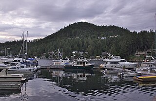
The Sunshine Coast is a geographic subregion of the British Columbia Coast that generally comprises the regional districts of qathet and Sunshine Coast.

Desolation Sound is a deep water sound at the northern end of the Salish Sea and of the Sunshine Coast in British Columbia, Canada.

Parts of this article have been adapted from the BC Parks website.

Bligh Island Marine Provincial Park is a provincial park in British Columbia, Canada.

Vargas Island Provincial Park is a provincial park in British Columbia, Canada, comprising the west side of the island of the same name, which is located west of Meares Island and northwest of the resort community of Tofino in the Clayoquot Sound region of the West Coast of Vancouver Island, British Columbia, Canada. The park was created as part of the Clayoquot Land-Use Decision on July 13, 1995 and contains 5,805 hectares, 1,543 hectares of it being upland and 4,262 hectares being foreshore. Also located on Vargas Island, on its north side, is Epper Passage Provincial Park.
Cormorant Channel Marine Provincial Park is a provincial park in British Columbia, Canada, located in the Pearse Islands, a small archipelago to the east of Cormorant Island and the Village of Alert Bay at the western end of Johnstone Strait.
Dawley Passage Provincial Park is a provincial park in British Columbia, Canada, located at the south end of Fortune Channel, which lies between Meares Island and the mainland of Vancouver Island just south. The park is to the north of the resort town of Tofino and is accessible by boat only. It was created on July 13, 1995 as part of the Clayoquot Land-Use Decision and contains 154 ha, .
Epper Passage Provincial Park is a provincial park in British Columbia, Canada, located on the north side of Vargas Island in the Clayoquot Sound region of the West Coast of Vancouver Island. Also on Vargas Island is Vargas Island Provincial Park. Other provincial parks nearby are Flores Island Marine Provincial Park, Gibson Marine Provincial Park, Maquinna Marine Provincial Park, Sydney Inlet Provincial Park, Dawley Passage Provincial Park and Hesquiat Peninsula Provincial Park. The park was created as part of the Clayoquot Land-Use Decision on July 13, 1995, and contains approximately 306 ha.

Flores Island Marine Provincial Park, also known as Flores Island Provincial Park, is a provincial park in British Columbia, Canada, located on the island of the same name in the central Clayoquot Sound region of the West Coast of Vancouver Island, British Columbia, Canada. The park contains 7113 ha. and was created on July 13, 1995, as part of the Clayoqout Land-Use Decision. Gibson Marine Provincial Park, which was created in 1967, adjoins it to the southeast. Sulphur Passage Provincial Park is off the northeast coast of Flores Island, surrounding Obstruction Island.

God's Pocket Marine Provincial Park is a provincial park in southwest British Columbia, Canada, established on July 12, 1995. It is well known as a cold water scuba diving and kayaking destination. The park is 2,036 hectares in size, and includes two main islands, Hurst and Bell, as well as many smaller isles.

Kitson Island Marine Provincial Park is a provincial park protecting all 45 hectares of Kitson Island and Kitson Islet. The park is located within the asserted traditional territory of the Tsimshian and Metlakatla First Nation, at the mouth of the Skeena River in British Columbia, Canada.

Mitlenatch Island Nature Provincial Park is a provincial park in British Columbia, Canada encompassing Mitlenatch Island, a small islet in the northern Strait of Georgia within the Strathcona Regional District.

Plumper Cove Marine Provincial Park is a provincial park in British Columbia, Canada. The park is located on the northwest shore of Keats Island in Howe Sound, northwest of Vancouver, British Columbia.
Sabine Channel Provincial Park, also known as Sabine Channel Marine Provincial Park, is a provincial park in British Columbia, Canada, in the waters surrounding Jervis Island in Sabine Channel, which separates Texada Island, to the north, from Lasqueti Island, which lies to the south. Established in 2001, the park is approximately 2,254 hectares in size.
Sulphur Passage Provincial Park is a provincial park in British Columbia, Canada, located in the central part of the Clayoquot Sound region of the West Coast of Vancouver Island, British Columbia, Canada. It is located around Obstruction Island to the northeast of Flores Island. The eponymous Sulphur Passage is located on the east side Obstruction Island.

BC Parks is an agency of the British Columbia Ministry of Environment and Climate Change Strategy that manages all of the, as of 2020, 1,035 provincial parks and other conservation and historical properties of various title designations within the province's Parks oversaw of the British Columbia Parks and Protected Areas System. The Lieutenant Governor-in-Council created the agency on March 1, 1911, through the Strathcona Park Act. The agency is charged with a dual role of preserving the ecological and historical integrity of the places entrusted to its management, while also making them available and accessible for public use and enjoyment.

Keats Island is an inhabited island located in Howe Sound near Vancouver, British Columbia. Most people who spend time on the island are visitors to one of the camps or the Marine Park, or owners of seasonal cottages.

Hot Springs Cove, formerly Refuge Cove, is an unincorporated settlement on Sydney Inlet on West Coast of Vancouver Island. It is located on the west side of the Openit Peninsula in the western Clayoquot Sound region. Hot Springs Cove derives its name from its proximity to Ramsay Hot Springs, and is protected by Maquinna Marine Provincial Park. The post office at Hot Springs Cove was closed in 1974 but had operated since 1947, when it was first named Sydney Inlet until being renamed in 1948. Despite the closure of the post office, there remains a year-round population in the vicinity.


