Pacific Rim National Park Reserve is a 511 km2 (197 sq mi) national park located in British Columbia, Canada, which comprises three separate regions: Long Beach, the Broken Group Islands, and the West Coast Trail. It is located in the Pacific Coast Mountains, which are characterized by rugged coasts and temperate rainforests.
Akamina-Kishinena Provincial Park is a provincial park located in the southeastern corner of British Columbia, Canada. The park was established by order-in-council on July 13, 1995 to protect the ecological integrity of a relatively narrow stretch of the Rocky Mountains in the southeastern corner of the province.

Pinecone Burke Provincial Park is a provincial park in British Columbia, Canada. It extends from the southwest corner of Garibaldi Provincial Park, west of Pitt Lake and Pitt River to include Burke Mountain in the City of Coquitlam. Most of the park is unserviced wilderness with very rough trails such as the Fools Gold Trail in the Boise Valley. There is canoe access to Widgeon Slough and from there hiking trails that lead to Widgeon Lake, and a network of old logging roads, hiking and mountain biking trails on Burke Mountain. Visitors can also use the park for camping, backcountry skiing, and snowshoeing.
Coquihalla River Provincial Park is a provincial park in British Columbia, Canada, located 25 km (16 mi) north of the town of Hope on BC Highway 5 adjacent to the Coquihalla River.
Cedar Point Provincial Park is a Class C provincial park located on the western end of Quesnel Lake in the Cariboo Region of British Columbia, Canada. As a Class "C" park, it is managed locally by a park board based in the nearby town of Likely. The park was established in 1962 and is approximately 8 hectares in area.

Sx̱ótsaqel/Chilliwack Lake Provincial Park is a provincial park in British Columbia, Canada. Covering 92.58 km2, the park is located 150 km east of Vancouver in the Chilliwack River Valley.
Choquette Hot Springs Provincial Park is a provincial park located in the Stikine Country region of British Columbia, Canada. It was established on January 25, 2001, to protect Stikine River Hot Springs, the largest hot springs on the Canadian side of the lower Stikine River.
Dune Za Keyih Provincial Park and Protected Area, also known as the Frog-Gataga Provincial Park, is a provincial park in British Columbia, Canada. It is part of the larger Muskwa-Kechika Management Area and is located in the area of the Gataga River, between Denetiah Provincial Park, which lies west across the Kechika River, and Kwadacha Wilderness Provincial Park to its east. Established in 2001 as Frog-Gataga, the park is 346,833 hectares in area; its newer name is a Kaska Dena translation of Frog-Gataga.
Denetiah Provincial Park and Protected Area is a provincial park and protected area located in the northern interior of British Columbia, Canada. It was established on June 29, 1999 to protect a large area of pristine wilderness at the headwaters of the Denetiah and Dahl Rivers.
Entiako Provincial Park is a provincial park in British Columbia, Canada, located on the south flank of the Nechako River watercourse.
Ferry Island Provincial Park is a Class C provincial park in British Columbia that is located on the south side of the Fraser River northeast of Rosedale. This park is northwest of Bridal Falls, British Columbia and adjacent to the Agassiz-Rosedale Bridge. The Ferry Island Park was established in 1963, and it has an area of about 29 hectares.

Juniper Beach Provincial Park is a provincial park in the Thompson Country region of south central British Columbia, Canada. The facility is on the north side of the Thompson River, west of the town of Savona, and downstream from the Kamloops Lake outflow. On BC Highway 1, the locality is by road about 20 kilometres (12 mi) east of Cache Creek and 65 kilometres (40 mi) west of Kamloops.

Juan de Fuca Provincial Park is a provincial park located on the west coast of Vancouver Island in British Columbia, Canada. The park was established on April 4, 1996 by combining three former parks — China Beach, Loss Creek, and Botanical Beach — into one provincial park. It is the location of the majority of the Juan de Fuca Marine Trail, which is a southern compliment to the West Coast Trail within Pacific Rim National Park Reserve.
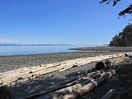
Kin Beach Provincial Park is a Class C provincial park in British Columbia, Canada, located just northwest of Kye Bay, to the north of Comox, British Columbia. As a Class "C" park, it is managed locally by a park board.

Kitson Island Marine Provincial Park is a provincial park protecting all 45 hectares of Kitson Island and Kitson Islet. The park is located within the asserted traditional territory of the Tsimshian and Metlakatla First Nation, at the mouth of the Skeena River in British Columbia, Canada.

Miracle Beach Provincial Park is a provincial park on the eastern shore of Vancouver Island in British Columbia, Canada. Located between Comox and Campbell River, the park includes a foreshore area in the Strait of Georgia, much of the Black Creek estuary, and a forested area. According to its Master Plan, it fulfills primarily a recreational role with a focus on beach play, picnicking, nature appreciation, and camping, and a secondary conservation role with a focus on the natural shoreline and estuary. In support of its recreational focus the park is developed with a day-use parking area with accessible trails leading to the shoreline and a camping area with 200 drive-in sites. The park is also hosts a nature centre building and a sheltered group picnic shelter. Vegetation in the park is typical for the region's second-growth forests with Douglas-fir most prominent. Common associates include Western hemlock, Sitka spruce, red alder and bigleaf maple. Salal and sword fern are the most abundant shrub. Black Creek, which flows through the park, is a spawning area for coho salmon.

Penrose Island Marine Provincial Park is a provincial park in the Central Coast region of British Columbia, Canada, located on the north side of the entrance to Rivers Inlet, 86 km north of Port Hardy at the south end of Fitz Hugh Sound. Comprising 1,079 hectares of marine area and 934 hectares of land area, the park is accessible by boat only and entrance to its anchorages are on its eastern side, the western being exposed to the open ocean. Exploration by dinghy and kayak are popular with visitors, as are nature viewing, scuba diving and exploring the islands many beaches and adjoining islets. The nearest supply centre for fuel and food is at the community of Rivers Inlet.

Rathtrevor Beach Provincial Park is a provincial park in Parksville, British Columbia, Canada. Located at the east end of the town, the 347-hectare park features a two-kilometre long stretch of sandy beach, a stand of old-growth Douglas fir trees and 250 vehicle-accessible and 25 walk-in camping spaces. Popular year-round, the park is easily accessible from Highway 19. The sandy beach is the main attraction. At low tide, it stretches nearly a kilometre out into the Strait of Georgia.
Sustut Provincial Park and Protected Area is a provincial park in British Columbia, Canada, located on the east side of the Sustut River and above the Bear River. Established by order-in-council in 2001, the park has an area of 75,037 ha. The park protects the Hogem Ranges and the Connelly Range and is in the traditional territories of the Tsay Keh Dene First Nation and the Gitxsan First Nation.
Tweedsmuir North Provincial Park and Protected Area is a provincial park in British Columbia, Canada, which along with Tweedsmuir South Provincial Park and Entiako Provincial Park were once part of Tweedsmuir Provincial Park, then B. C.'s largest park, 9,810 square kilometres (3,790 sq mi) located in the Coast Range.