Widgeon Valley National Wildlife Area

Last updated

Widgeon Valley National Wildlife Area
Canada British Columbia location map 2.svg
Red pog.svg
Location in British Columbia
15 Metro Vancouver Regional District British Columbia.svg
Red pog.svg
Location Metro Vancouver, British Columbia, Canada
Nearest city Pitt Meadows
Coordinates 49°22′10″N122°38′00″W / 49.36944°N 122.63333°W / 49.36944; -122.63333
Area125 ha (310 acres)
Designation National Wildlife Area
EstablishedOctober 1973
Governing body Canadian Wildlife Service
Website www.canada.ca/en/environment-climate-change/services/national-wildlife-areas/locations/widgeon-valley.html

Widgeon Valley National Wildlife Area is a National Wildlife Area located near the south end of Pitt Lake in British Columbia, Canada. [2] The property was purchased by the Nature Trust of British Columbia in 1973 and declared a National Wildlife Area by the Canadian Wildlife Service in October of that year. [3] The Widgeon Valley National Wildlife Area is a biologically diverse marsh wetland. [4] It is the traditional territory of various First Nations groups. [5] The Widgeon Valley Wildlife Area is a protected wildlife area that is home to a number of sensitive waterfowl and fish species. [6] The public uses the channels through the Widgeon Valley National Wildlife Area for recreational canoeing, anywhere else within the protected area is strictly off-limits to the public. [5] There are future plans to develop interpretive trails through the park and open it to the public. [7]

Contents

Ecology

Despite its small size, Widgeon Valley NWA hosts a variety of habitat types. The central lowlands are dominated by a dense stand of hardhack interspersed with grasses, forbs, and skunk cabbage. The uplands along the western end of the NWA feature a mixed deciduous-conifer woodland. The wetlands of Widgeon Valley feature lodgepole pine interspersed within a diverse collection of shrubby vegetation, most notably Labrador tea and horsetail. [3]

The wetlands of Widgeon Valley provide critical habitat for migratory waterfowl and other wetland-dependent wildlife. Its close proximity to Pitt Polder and other wetland areas contribute to the biodiversity and ecological resilience of the Pitt Lake region. [3]

History

Given that one of the main activities of the Katzie First Nation was harvesting waterfowl, anadromous and freshwater fish, these may have been common species within Widgeon Creek, it is also possible that shellfish could have been a common species within the surrounding waterbodies given the evidence of shell middens that can be found in the Pitt Lake. Popular vegetation and plant species would have been cranberries, wapato, and berries as these were commonly cultivated by the Katzie. The red cedar and hemlock trees were quite vast and popular as they were often harvested and used by the Katzie for hunting, trading, and gathering purposes. [4]

Wetland status

The marsh wetland ecosystem in Widgeon Valley National Wildlife Area is one of few remaining wetland ecosystems in British Columbia. Estimates of British Columbia's wetland ecosystem land area vary from 5.6% (5.28 million hectares) to 7%. [8] [9] An approximate 85% of British Columbia’s freshwater wetland ecosystems have been either disturbed or destroyed completely. [8] [10] Threats to wetland ecosystems include invasive species; land development activities, such as mining and oil and gas extraction; forest management practices, and recreational activities. [11] The majority of British Columbia’s wetland ecosystems are located in and around the developed Lower Mainland. [12]

Adjacent wetlands to Widgeon Valley National Wildlife Area include the Pitt Polder Ecological Reserve, a fen wetland, and the Pitt Addington Wildlife Management Area, a swamp wetland. [12]

Wildlife

The Widgeon Valley’s proximity to the Pacific Flyway has made it a local hotspot for avian wildlife. [6] Red-tailed hawk, and western screech owls (Kennicotti) fill the valley’s avian predator niche. [6] Aquatic migratory birds such as the Canada goose, and several varieties of duck; mallard, wood, and cinnamon teal occupy the valley's water system. [6] Northern pintails, greater scaups, common goldeneyes, bufflehead, dunlins, horned grebes, and western grebes also make the Widgeon Valley their winter refuge. [6] The aquatic ecosystem supports fish such as steelhead, cutthroat trout, and a unique population of sockeye salmon that have adapted to the water system's tidal conditions. [13] Amphibians such as northwestern salamanders, rough skinned newts and red legged frogs can be found in the Widgeon Valley's large marsh. [13] Larger fauna include beaver, river otter, with cougars, bobcats, black bears, and deer also frequenting the area. [6] [13]

Western screech owl

The western screech owl’s (Kennicotti) risk status was raised from "special concern" to "threatened" in 2017 by Canada’s Species at Risk Registry (SARA). [14] The total population is estimated to be 10000 individuals across the coast of British Columbia. [15] The most recent estimates show a population decline of at least 30% from the early 2000s to 2014. [15] In some regions such as Metro Vancouver, where human activities and habitat destruction is of a high degree, the western screech owl has been extirpated. [15] The Western Screech owl is being outcompeted and preyed upon by the invasive barred owl. The Widgeon Valley is an essential region to the western screech owl as its main competitor, the barred owl, has yet to establish a population in the valley. [6] Climate change poses a significant threat to the western screech owl through habitat destruction and resource depletion. Extreme summers cause heat waves resulting in decreased biodiversity and increased resource scarcity. [13] Increased frequency of extreme weather such as storms and floods fell trees used as shelter by the Western Screech owl. [13]

Vegetation

Much of the Widgeon Valley is dominated by wetland vegetation as the largest ecosystem of the protected area is marsh. [6] The marsh supports a sweet gale shrub community with much of the area being densely populated by shrubbery. [13] Indigenous groups have traditionally harvested many of the edible plants in the marsh such as wapato, wild rice, bog blueberries, bog cranberries, and water plantain. [6] [13] Widgeon Valley's forests also supports many edible plants such as salmon berry, black caps, coastal strawberry, trailing blackberry, salal berry, thimbleberry, saskatoon berry, and huckleberry. [6] [13] Widgeon Valley is located within the Coastal Western Hemlock dry maritime biogeoclimatic zone with approximately 66% its forests being dominated by two distinct ecosystems: the hemlock and flat moss ecosystem, and the red cedar and sword fern ecosystem. [13] The widgeon valley hosts trees such as douglas fir, sitka spuce, red abig-leaf, and big leaf maple. [6] [13] The age of the trees vary based on location and species due to logging. Hemlock and red cedar make up the older population being considered second growth while big leaf maple trees in the area are significantly younger. [13]

Invasive species

Several non-native plant species have been observed in Widgeon Valley National Wildlife Area, some of which are considered invasive species. [4] Many of these invasive species have been introduced from local residential areas. [4] A list of observed invasive species in Widgeon Valley National Wildlife Area can be found below.

Invasive Plant Species in Widgeon Valley National Wildlife Area [4]
Bog Loosestrife
Butterfly bush
Bulbous rush
Canada thistle
Common foxglove
Common St. John’s-wort
English holly
English ivy
European mountain-ash
Evergreen blackberry
Hairy cat’s-ear
Hedge bindweed
Himalayan blackberry
Japanese knotweed
Orange hawkweed
Purple loosestrife
Reed canarygrass
Scotch broom
Small touch-me-not
Southern wild rice (Zizania aquatica var. aquatic)
Sticky ragwort
Yellow archangel
Yellow flag iris

Human activity

Aboriginal history

For thousands of years prior to Widgeon Valley becoming protected, the Katzie First Nations occupied the area. [5] The Katzie people used the Widgeon Valley Wildlife Area to fish for freshwater fish, to hunt small animals and waterfowl, to gather cedar bark, and even used the slough banks to cultivate wild cranberries and wapato. [5] Widgeon Valley was used for ceremonial purposes by the Katzie First Nation, Kwikwetlem First Nation, Stó:l– o First Nation, Tsawwassen First Nation, Soowahlie First Nation, Shxw’ow’hamel First Nation, Skawahlook First Nation, and The Seabird Island Band. [7] [5] Ethnographers have discovered at least one ancient Katzie village within the wildlife area. [5]

Ownership

In 1940, two logging companies sold the land that would become The Widgeon Valley National Wildlife Area to the Burnett family. [5] The Burnett family later sold the land to The Nature Trust of British Columbia in 1973, who later that year leased the land for 99 years to Environment and Climate Change Canada for conservation purposes. [5] These areas are established to protect sensitive species and species at risk. [5] The Widgeon Valley National Wildlife Area would become part of a larger complex of wildlife areas set within the largest natural freshwater marsh in Southwestern British Columbia. [16]

Recreational use

The channels through the Widgeon Valley National Wildlife Area are open to the public. [5] Canoes and other non-motorized floatation devices are permitted in the channels, and many people use the channels to reach Widgeon Creek campsite in Pinecone Burke Provincial Park. [5] A nearby canoe renrents outtion rents-out up to 60 canoes a day. [17] [5] The most recreational use of the Widgeon Valley channels happens mid-fall through to early spring as the waterfowl population within the channels is at its highest. [5] Many people exit their canoes explore and to picnic in the wildlife area, which becomes potentially harmful to the protected area. [5] Most of the conservation efforts within the Widgeon Valley National Wildlife Area go towards putting up signs along the channels banks to deter people from entering the protected wildlife areas. [5]

Future plans

Plans approved in 2019 by the Metro Vancouver Regional District include opening the Widgeon Valley National Wildlife Area to the public. [7] The future plans involve the development of numerous trails, day-use areas, facilities, interpretive signage, a canoe launch, and canoe tie-offs along the channel. [7] These developments will cover roughly 6% of the Widgeon Valley National Wildlife Area. [7] Consultation and planning will be done with the Katzie First Nation as well as numerous other local First Nations that have historically used the area. [7] Interpretive signage along the trails through the Widgeon Valley National Wildlife Area will provide information to the public about the natural and cultural history of the Except [7] With the exception of hunting, First Nations will once again be able to use the land traditionally. [7]

Geography

The protected area is located in a broad, flat-bottomed valley immediately west of the south end of Pitt Lake. The valley is dominated by Widgeon Creek, which meanders throughout the valley to form a vast wetland before draining into Widgeon Slough. [18]

Geomorphology

Major glacial movement and processes have been key components of Widgeon Valley's current landscape. The landscape's formation can be attributed to a major glacial advance in which ice covered the land over 10,000 years ago, retreated, and left numerous fiords and elongated lakes in interior valleys and the valley’s typical U-shape. The rapid expansion of the Fraser River delta is believed to be the major cause of the formation of both Widgeon valley and Pitt Lake about 7,000 to 8,000 years ago when these two were believed to be former fiords before being sealed off by this fluvial process. [4]

Terrestrial and aquatic habitats

While Widgeon Valley comprises both wetland and terrestrial habitats, it is dominated by wetlands. Riverine and slough processes are the most significant traits of Widgeon Valley wetlands, these processes and occurrences are synonymous with the Widgeon Creek channels. The existence of high elevated banks of riverine and tidal sloughs supports riparian shrub species and some trees. The high occurrence of tidal sloughs has created so many channels and allowed the scattering of open ponds throughout the interior with its connection to the river. The Ponds are also surrounded by herbaceous wetland habitats which are flooded seasonally. [4] [19]

Extending from riparian streams, and slough banks down to herbaceous wetlands are the Hardhack shrub regions which are the biggest habitat type that includes large areas of mixed communities and species of herbaceous plants and encroaching shrubs. Despite comprising mainly wetland habitats, the valley has terrestrial habitats that are made up of old-growth and second-growth forests. [4] [19]

See also

Related Research Articles

<span class="mw-page-title-main">Tantramar Marshes</span>

The Tantramar Marshes, also known as the Tintamarre National Wildlife Area, is a tidal saltmarsh around the Bay of Fundy on the Isthmus of Chignecto. The area borders between Route 940, Route 16 and Route 2 near Sackville, New Brunswick. The government of Canada proposed the boundaries of the Tantramar Marshes in 1966 and was declared a National Wildlife Area in 1978.

<span class="mw-page-title-main">Missisquoi National Wildlife Refuge</span>

Missisquoi National Wildlife Refuge is a National Wildlife Refuge located in the eastern shore of Lake Champlain in the U.S. state of Vermont. The refuge is in Franklin County in the northwest corner of the state near the International Boundary with Canada. It is the only National Wildlife Refuge located entirely in Vermont, and is administered by the United States Fish and Wildlife Service.

<span class="mw-page-title-main">Suisun Marsh</span> Largest brackish water marsh on west coast of US

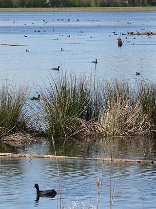
Located in northern California, the Suisun Marsh has been referred to as the largest brackish water marsh on west coast of the United States of America. The marsh land is part of the San Francisco Bay tidal estuary, and subject to tidal ebb and flood. The marsh is home to many species of birds and other wildlife, and is formed by the confluence of the Sacramento and San Joaquin rivers between Martinez and Suisun City, California and several other smaller, local watersheds. Adjacent to Suisun Bay, the marsh is immediately west of the legally defined Sacramento-San Joaquin Delta as well as part of the San Francisco Bay estuary.

<span class="mw-page-title-main">Pinecone Burke Provincial Park</span> Provincial park in British Columbia, Canada


Pinecone Burke Provincial Park is a provincial park in British Columbia, Canada. It extends from the southwest corner of Garibaldi Provincial Park, west of Pitt Lake and Pitt River to include Burke Mountain in the City of Coquitlam. Most of the park is unserviced wilderness with very rough trails such as the Fools Gold Trail in the Boise Valley. There is canoe access to Widgeon Slough and from there hiking trails that lead to Widgeon Lake, and a network of old logging roads, hiking and mountain biking trails on Burke Mountain. Visitors can also use the park for camping, backcountry skiing, and snowshoeing.

<span class="mw-page-title-main">Golden Ears Provincial Park</span> Provincial park in British Columbia, Canada

Golden Ears Provincial Park is a Provincial park in British Columbia, Canada and is 555.9 square kilometres (214.6 sq mi). It is named after the prominent twin peaks which are commonly referred to as Golden Ears. The park was originally part of Garibaldi Provincial Park but was split off as a separate park in 1967. Golden Ears Provincial Park is situated in the unceded traditional territories of the Coast Salish people. The area was logged extensively in the 1920s by the Lougheed and Abernathy Logging Company. Many recreational attractions are found within the park. Golden Ears Provincial Park is a protected area that contains many endangered species of flora and fauna.

<span class="mw-page-title-main">Ankeny National Wildlife Refuge</span>

Ankeny National Wildlife Refuge is located in the fertile Willamette Valley of northwestern Oregon, 12 miles (19 km) south of Salem. The valley was once a rich mix of wildlife habitats. Valley wetlands were once extensive, with meandering stream channels and vast seasonal marshes. Today, the valley is a mix of farmland and growing cities, with few areas remaining for wildlife.

<span class="mw-page-title-main">Baskett Slough National Wildlife Refuge</span>

Baskett Slough National Wildlife Refuge is in northwestern Oregon, 10 miles (16 km) west of Salem in Polk County. The Refuge consists of 1,173 acres (4.75 km²) of cropland, which provide forage for wintering geese, 300 acres (1.2 km²) of forests, 550 acres (2.2 km²) of grasslands, and 500 acres (2.0 km²) of shallow water seasonal wetlands and 35 acres (0.14 km²) of permanent open water. In 1965, Baskett Slough National Wildlife Refuge was created to help ensure some of the original habitat remained for species preservation. The refuge is managed by the U.S. Fish and Wildlife Service, an agency of the U.S. Department of the Interior.

<span class="mw-page-title-main">Alaksen National Wildlife Area</span> National Wildlife Area of Canada in Delta, British Columbia

The Alaksen National Wildlife Area is located on Westham Island in the city of Delta, British Columbia. It is an important stopover point for many species of birds migrating along the Pacific Flyway.

<span class="mw-page-title-main">Oak Hammock Marsh</span> Marsh in Manitoba, Canada

Oak Hammock Marsh is a marsh and a wildlife management area located 34 kilometres (21 mi) north of Winnipeg, Manitoba, Canada. The WMA is considered to be a Class IV protected area under the IUCN protected area management categories. The marsh is recognized as an Important Bird Area (IBA) for its globally significant numbers of waterfowl and shorebirds. It is a designated Ramsar site due to its international importance as a breeding and staging area for waterfowl and other migratory birds. It is 3,578.47 hectares in size.

<span class="mw-page-title-main">Elkhorn Slough</span> Body of water in Monterey County, California

Elkhorn Slough is a 7-mile-long (11 km) tidal slough and estuary on Monterey Bay in Monterey County, California. It is California's second largest estuary and the United States' first estuarine sanctuary. The community of Moss Landing and the Moss Landing Power Plant are located at the mouth of the slough on the bay.

<span class="mw-page-title-main">Okanagan Desert</span>

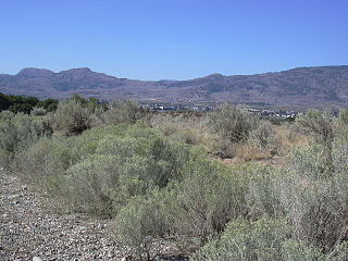
The Okanagan Desert is the common name for a semi-arid shrubland located in the southern region of the Okanagan Valley in British Columbia and Washington. It is centred around the city of Osoyoos and is the only semi-arid shrubland in Canada. Part of this ecosystem is referred to as the Nk'mip Desert by the Osoyoos Indian Band, though it is identical to the shrublands elsewhere in the region. To the northwest of this area lies an arid shrubland near Kamloops.

<span class="mw-page-title-main">Turnbull National Wildlife Refuge</span>

The Turnbull National Wildlife Refuge is located six miles (10 km) south of Cheney, Washington, on the eastern edge of the Columbia Basin in Spokane County in northeastern Washington. Turnbull NWR encompasses more than 18,000 acres (7,300 ha) of the Channeled Scablands. The ecosystem that predominates the refuge is unique within the National Wildlife Refuge System and has characteristics that distinguish it from natural reserves worldwide. The combination of basalt outcrops, channeled canyons, and ponderosa pine forests infused in a diverse landscape of over 130 marshes, wetlands, and lakes creates an environment of aesthetic beauty as well as high quality wildlife habitat. The refuge is named for Cyrus Turnbull who lived on the site in the 1880s.

Lake Ophelia National Wildlife Refuge was established in 1988 to protect the Mississippi/Red River floodplain ecosystem. The refuge is located in Avoyelles Parish, Louisiana, east central Louisiana. The refuge is named for its most prominent water body, the 350-acre (1.4 km2) Lake Ophelia that was at one time a channel of the nearby Red River of the South.

<span class="mw-page-title-main">Smith and Bybee Wetlands Natural Area</span> Public park and nature reserve in Portland, Oregon, U.S.

Smith and Bybee Wetlands Natural Area is a public park and nature reserve between the Columbia Slough and the Columbia River in Portland, Oregon. At about 2,000 acres (810 ha), it is one of the largest urban freshwater wetlands in the United States. Metro, the regional government for the Oregon part of the Portland metropolitan area, manages the park. A covered shelter, restrooms, a paved walkway, and a canoe launch lie on the north side of the natural area.

<span class="mw-page-title-main">Summer Lake Wildlife Area</span> Wildlife refuge in Oregon

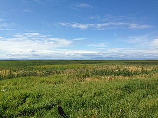
The Summer Lake Wildlife Area is a 29.6-square-mile (77 km2) wildlife refuge located on the northwestern edge of the Great Basin drainage in south-central Oregon. It is administered by the Oregon Department of Fish and Wildlife. The refuge is an important stop for waterfowl traveling along the Pacific Flyway during their spring and fall migrations. The Summer Lake Wildlife Area also provides habitat for shorebirds and other bird species as well as wide variety of mammals and several fish species. The Ana River supplies the water for the refuge wetlands.

<span class="mw-page-title-main">Marshall-Stevenson Wildlife Sanctuary</span> Wetlands area in Canada

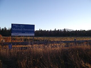
The Marshall-Stevenson Wildlife Sanctuary is a limited-access wetlands area located on Vancouver Island west of Qualicum Beach, British Columbia, Canada.

Vaseux-Bighorn National Wildlife Area is a National Wildlife Area in British Columbia, Canada, primarily set aside to protect winter rangeland for California bighorn sheep. In 1979, the Vaseux-Bighorn Wildlife Area was established in response to substantial reduction in wild animal populations in the area. Identified factors contributing to species decline at the time were high predator population, overharvesting of species, and illegal hunting. Land development, cattle raising, and lumbering also might have altered species populations. Under these conditions, the area was able to be classified as a Category IV area by the IUCN and is now used for wildlife habitat and conservation. Even with minimal anthropogenic use of the area, threats persist through invasive species. Recreational use is limited spatially and is only open to the public during the day.

Located in the southern part of British Columbia, Columbia National Wildlife Area was established to protect its wetlands and as a temporary home for migratory birds travelling to South America. The National Wildlife Area (NWA) is divided into four unit areas: Wilmer, Spillimacheen, Brisco and Harrogate, which are home to many diverse species of animals and plants which are significant in Canada.

<span class="mw-page-title-main">Puget lowland forests</span> Temperate coniferous forest ecoregion in British Columbia, Canada and Washington, United States

Puget lowland forests is a temperate coniferous forest ecoregion the Pacific coast of North America, as defined by the World Wildlife Fund (WWF) categorization system.

References

  1. "Widgeon Valley National Wildlife Area". Protected Planet. Retrieved 15 September 2020.
  2. "Widgeon Valley National Wildlife Area". BC Geographical Names .
  3. 1 2 3 Canada, Environment and Climate Change (25 November 2011). "Widgeon Valley National Wildlife Area". aem. Retrieved 29 October 2020.
  4. 1 2 3 4 5 6 7 8 "Widgeon Marsh Regional Park Reserve: Biophysical Summary." Metro Vancouver. Retrieved 2022-10-28.
  5. 1 2 3 4 5 6 7 8 9 10 11 12 13 14 15 Government of Canada, Public Services and Procurement Canada. "Information archivée dans le Web" (PDF). publications.gc.ca. Retrieved 8 October 2022.
  6. 1 2 3 4 5 6 7 8 9 10 11 "Widgeon Valley National Wildlife Area". Canada.ca. 10 March 2020. Retrieved 10 October 2020.
  7. 1 2 3 4 5 6 7 8 "Widgeon Marsh Regional Park Management Plan 2019" (PDF). Retrieved 12 October 2022.
  8. 1 2 Strategy, Ministry of Environment and Climate Change. "Wetlands in B.C. - Province of British Columbia". www2.gov.bc.ca. Retrieved 14 October 2022.
  9. "Taking Nature's Pulse: The Status of Biodiversity in British Columbia". www.biodiversitybc.org. Retrieved 14 October 2022.
  10. "British Columbia". Ducks Unlimited Canada. Retrieved 14 October 2022.
  11. "Wetlands Action Plan for BC." https://bc-wetlands.ca . Retrieved 2022-10-14.
  12. 1 2 "Canadian Wetland Inventory Progress Map". maps.ducks.ca. Retrieved 14 October 2022.
  13. 1 2 3 4 5 6 7 8 9 10 11 "Widgeon Marsh Regional Park DRAFT Management Plan 2019" (PDF). www.metrovancouver.org. March 2019. Retrieved 10 October 2022.
  14. "Western Screech-Owl kennicottii subspecies (Megascops kennicottii kennicottii)". Canada.ca. 2 February 2021. Retrieved 10 October 2022.
  15. 1 2 3 Gahbauer, Marcel; McCracken, Jon (December 2014). "Review of the COSEWIC 2012 assessment of Western Screech-Owl (kennicottii subspecies)" (PDF). www.sararegistry.gc.ca.
  16. Gebauer, Martin (2020). "Desktop assessment of species at risk occurrence at the Widgeon Valley National Wildlife Area, British Columbia". Environment Canada.
  17. "Active Vancouver : A Year-round Guide to Outdoor Recreation in the City's Natural Environments | Canada Commons". viewer.canadacommons.ca. Retrieved 8 October 2022.
  18. "Widgeon Slough". apps.gov.bc.ca. Retrieved 29 October 2020.
  19. 1 2 Government of Canada, Public Services and Procurement Canada (1 July 2002). "Widgeon Valley Wildlife Area management plan. : CW66-587/2019E-PDF - Government of Canada Publications - Canada.ca". publications.gc.ca. Retrieved 7 November 2022.

Commons-logo.svg Media related to Widgeon Valley National Wildlife Area at Wikimedia Commons