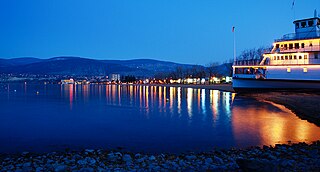
Penticton is a city in the Okanagan Valley of the Southern Interior of British Columbia, Canada, situated between Okanagan and Skaha lakes. In the 2016 Canadian Census, its population was 33,761, while its census agglomeration population was 43,432.

The Okanagan, also called the Okanagan Valley and sometimes the Okanagan Country, is a region in the Canadian province of British Columbia defined by the basin of Okanagan Lake and the Canadian portion of the Okanagan River. It is part of the Okanagan Country, extending into the United States as Okanogan County in north-central Washington. According to the 2016 Canadian census, the region's population is 362,258. The largest populated cities are Kelowna, Penticton, Vernon, and West Kelowna.

Okanagan Mountain Provincial Park is a provincial park within the Okanagan-Similkameen Regional District of British Columbia, Canada, focused on the mountain of the same name and located on the east side of Okanagan Lake, opposite Peachland and immediately south of the City of Kelowna. The park is one of the largest in the area, covering 110.38 square kilometres (42.62 sq mi). Most of the park is only accessible by foot, horseback, bicycle, or boat as motor vehicle access is restricted to BC Parks staff and technicians servicing the three telecommunications towers in the park.

Pinecone Burke Provincial Park is a provincial park in British Columbia, Canada. It extends from the southwest corner of Garibaldi Provincial Park, west of Pitt Lake and Pitt River to include Burke Mountain in the City of Coquitlam. Most of the park is unserviced wilderness with very rough trails such as the Fools Gold Trail in the Boise Valley. There is canoe access to Widgeon Slough and from there hiking trails that lead to Widgeon Lake, and a network of old logging roads, hiking and mountain biking trails on Burke Mountain. Visitors can also use the park for camping, backcountry skiing, and snowshoeing.

Cathedral Provincial Park and Protected Area, usually known as Cathedral Provincial Park and also as Cathedral Park, is a provincial park in British Columbia, Canada. It is located east of E.C. Manning Provincial Park, south of BC Highway 3, and southeast of the town of Princeton, and southwest of Keremeos. Its southern boundary is the border with the United States. Much of the park is the basin of the Ashnola River. Cathedral Park is home to teal sub-alpine lakes, vast ridges and jarred peaks, old-growth forests, and rock formations of siltstone, granodiorite, and basalt. Hikers can scramble along various peaks such as the 8000-foot Grimface Mountain and Lakeview Mountain. Tourists flock to Smokey the Bear and Stone City because of their unique formations with incredible views formed by millennia of erosion, volcanic and tectonic activity, and glacial recession.

Golden Ears Provincial Park is a 555.9 square kilometres (214.6 sq mi) provincial park in British Columbia, Canada. It is named after the prominent twin peaks, which are commonly referred to as Golden Ears. The park was originally part of Garibaldi Provincial Park but was split off as a separate park in 1967. The area was logged extensively in the 1920s by the Lougheed and Abernathy Logging Company. Many recreational attractions are found within the park. Golden Ears Provincial Park is a protected area that contains many endangered species of flora and fauna.
Driftwood Canyon Provincial Park is a provincial park in British Columbia, Canada. Driftwood Canyon Provincial Park covers 23 hectares of the Bulkley River Valley, on the east side of Driftwood Creek, a tributary of the Bulkley River, 10 km northeast of the town of Smithers. The park is accessible from Driftwood Road from Provincial Highway 16. It was created in 1967 by the donation of the land by the late Gordon Harvey (1913–1976) to protect fossil beds on the east side of Driftwood Creek. The beds were discovered around the beginning of the 20th century. The park lands are part of the asserted traditional territory of the Wet'suwet'en First Nation.

E.C. Manning Provincial Park is a provincial park in British Columbia, Canada. It is usually referred to as Manning Park, although that nomenclature is also used to refer to the resort and ski area at the park's core. The park covers 83,671 hectares (323 mi2) and was the second most visited provincial park in 2017-18 after Cypress Provincial Park. The park lies along British Columbia Highway 3, and occupies a large amount of land between Hope and Princeton along the Canada-United States border.

sw̓iw̓s Provincial Park is a provincial park in British Columbia, Canada, located on the west side of Osoyoos Lake in the town of Osoyoos, which is on the Canada-United States border at the southern end of the Okanagan region of British Columbia. Approximately 38 hectares in size, the park was originally created in 1939. The name was changed from Haynes Point to sw̓iw̓s, the original Okanagan (Syilx'tsn) name for the region, meaning "narrowing of the waters".
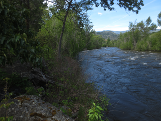
Inkaneep Provincial Park is a provincial park near Oliver, British Columbia, Canada, located just south of the town of Okanagan Falls. The park contributes to the protection of critical riparian values on the Okanagan River. The park is popular with naturalists, particularly bird-watchers. First Nations have identified the river and riparian area of the park as very important contributor to the long-term viability of the Okanagan River salmon run.

MacMillan Provincial Park is a 301-hectare (740-acre) provincial park in British Columbia, Canada. Located 25 km (16 mi) west of Qualicum Beach and 16 km (9.9 mi) east of Port Alberni, the park straddles Highway 4 and the Island Rail Corridor in central Vancouver Island. It is nestled on the western shore of Cameron Lake, and protects the delta of the Cameron River. The park is home to a famous, 157-hectare (390-acre) stand of ancient Douglas fir, known as Cathedral Grove, which draws visitors from all over the world. The park provides the only highway-accessible protected old-growth Douglas-fir forest in British Columbia. In 2007 Cathedral Grove made the short list on CBC's competition Seven Wonders of Canada.
Okanagan Falls Provincial Park, now officially named sx̌ʷəx̌ʷnitkʷ Provincial Park, is a provincial park in British Columbia, Canada, located within the traditional territory of the Osoyoos Indian Band. Since time immemorial, the Osoyoos Indian Band's Okanagan ancestors have inhabited and cared for the lands and waters in their traditional territory. The park is also located within the town of Okanagan Falls, protecting the area around the waterfall of the same name, which lies below the outlet of Skaha Lake in the course of the Okanagan River.

Sun-Oka Beach Provincial Park is a provincial park in British Columbia, Canada. Established as Claybanks Beach Park in 1969, the park covers a total area of 30 hectares, the park also conserves 558m of shoreline and 100m of Okanagan Lake foreshore.

Vaseux Lake is a shallow freshwater lake located along the course of the Okanagan River in the Okanagan Valley of British Columbia, Canada.
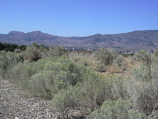
The Okanagan Desert is the common name for a semi-arid shrubland located in the southern region of the Okanagan Valley in British Columbia and Washington. It is centred around the city of Osoyoos and is the only semi-arid shrubland in Canada. Part of this ecosystem is referred to as the Nk'mip Desert by the Osoyoos Indian Band, though it is identical to the shrublands elsewhere in the region. To the northwest of this area lies an arid shrubland near Kamloops.

South Chilcotin Mountains Provincial Park is a provincial park in British Columbia, Canada, located on Highway 40 northwest of Lillooet, British Columbia. The park, which is 56,796 ha. in size, was established on April 18, 2001, and It was created out of a portion of the Spruce Lake Protected Area. The park is located on three Indigenous Nations: The Tsilhqot’in, St’at’imc, and Secwepemc.

Mount Seymour Provincial Park is a park in Vancouver, British Columbia's North Shore Mountains. With an area of 35 square kilometres, it is located approximately 15 kilometres north of Downtown Vancouver. The park, named after Frederick Seymour, was established in 1936. Mount Seymour Provincial Park provides visitors with a variety of recreational activities and animals with natural habitat.
Vaseux-Bighorn National Wildlife Area is a National Wildlife Area in British Columbia, Canada, primarily set aside to protect winter rangeland for California bighorn sheep. In 1979, the Vaseux-Bighorn Wildlife Area was established in response to substantial reduction in wild animal populations in the area. Identified factors contributing to species decline at the time were high predator population, overharvesting of species, and illegal hunting. Land development, cattle raising, and lumbering also might have altered species populations. Under these conditions, the area was able to be classified as a Category IV area by the IUCN and is now used for wildlife habitat and conservation. Even with minimal anthropogenic use of the area, threats persist through invasive species. Recreational use is limited spatially and is only open to the public during the day.

The Central British Columbia Mountain forests is a temperate coniferous forest ecoregion in north-central British Columbia, as defined by the World Wildlife Fund (WWF) categorization system.

White Lake Grasslands Protected Area is a conservation site located in the Regional District of Okanagan-Similkameen of British Columbia, Canada. It was established on April 18, 2001 by an order-in-council under the Environment and Land Use Act to protect the semi-arid grassland and pine forest ecosystem west of Vaseux Lake.


