Indian rodeo is the rodeo subculture of Native-American rodeo athletes and, in Canada, First Nations athletes. In the United States, there are a number of regional associations and at least two national finals. In Canada, Indian rodeos share a major role in small aboriginal communities and are also featured events in larger centres with aboriginal populations. Some major rodeos in British Columbia such as the Williams Lake Stampede are, while not aboriginally-organized and unlike some Indian rodeos open to non-natives, heavily "Indian" in character and in the ranks of competitors. The Indian rodeo is sponsored by a few well known companies including the Boot Barn, Cooper Tires and Yeti.

Quesnel is a city located in the Cariboo Regional District of British Columbia, Canada. Located nearly evenly between the cities of Prince George and Williams Lake, it is on the main route to northern British Columbia and the Yukon. Quesnel is located at the confluence of the Fraser River and Quesnel River. As of 2021, Quesnel's metropolitan area had a population of 23,113 making it one of the largest urban centres between Prince George and Kamloops.
The Stuart River or Nak'alkoh is one of the largest tributaries of the Nechako River in northeastern British Columbia, Canada. The Nechako is in turn one the more important tributaries of the Fraser River. The Stuart River flows 187 kilometres (116 mi) from Stuart Lake to its junction with the Nechako River. The river drains a portion of the Nechako Plateau—a gently-rolling region characterized by small lakes and tributaries. Low but impressive ridges interact with the river, creating high bluffs and hoodoos.

Adams Lake Provincial Park is a provincial park in British Columbia, Canada. It encompasses three distinct parks: Adams Lake Provincial Park, Adams Lake Marine Provincial Park, and Adams Lake Marine Provincial Park.
Babine Lake Marine Park is on Babine Lake, which borders the Skeena and Omineca regions of central British Columbia. This provincial park comprises six separate sites around the lake. Vehicle access to the lake, via BC Highway 16 and Nilkitkwa forestry service road, is by road about 105 kilometres (65 mi) northeast of Smithers; via BC Highway 16 and Central Babine Lake Highway, is about 132 kilometres (82 mi) east of Smithers; or via Babine Lake Road, is about 20 kilometres (12 mi) northeast of Burns Lake.

Tā Chʼilā Provincial Park, formerly Boya Lake Provincial Park, is a provincial park located in the Stikine Region of British Columbia, Canada. The park located 120 km north-by-northwest of the community of Dease Lake near BC Highway 37. Boya Lake is named for Charlie Boya, a First Nations man from the area.

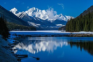
Duffey Lake Provincial Park is a provincial park in British Columbia, Canada, located at the lake of the same name, which lies along BC Highway 99 just east of the summit of Cayoosh Pass. The lake's inflow and outflow are Cayoosh Creek. The park's highest point is Mount Rohr at the westernmost boundary.

Davis Lake Provincial Park is a 185 acres (0.75 km2) park in British Columbia, Canada, established as a protected provincial park in October 1963. It is located east of the southern end of Stave Lake, northeast of Mission, British Columbia, approximately 18 km north on Sylvester Rd from BC Highway 7. There are campgrounds and beaches at the south end of the lake, access is walk-in only via a 1 km unmaintained gravel road.
Elk Lakes Provincial Park is a provincial park in southeastern British Columbia, Canada, located west of the continental divide. It is located adjacent to Height of the Rockies Provincial Park and is about 104 kilometers north of Sparwood. The park features sub-alpine landscapes, remnant glaciers, rugged peaks and productive lakes. Much of the park is above treeline and features several prominent mountains including Mount Fox, Mount Aosta, Mount McCuaig, and Mount Elkan. The Petain, Castelnau, Nivelle, and Elk Glaciers lie on the northeastern edge of the park. The following lakes are also present inside park boundaries: Upper and Lower Elk Lake, Frozen Lake, Fox Lake, Cadorna Lake, and Abruzzi Lake. Below the treeline, the park features mature growth forests of alpine fir, Engelmann spruce, and lodgepole pine. These trees are also intermingled with juniper, twinberry, false azalea, white rhododendron, and buffalo berry. The wildlife of the area includes Beaver, Snowshoe Hare, Red Squirrel, white-tailed deer, moose, and many varieties of birds.
Kootenay Lake Provincial Park is a provincial park in British Columbia, Canada. It encompasses five widely dispersed parks around Kootenay Lake: Kootenay Lake Provincial Park, Kootenay Lake Provincial Park, Kootenay Lake Provincial Park, Kootenay Lake Provincial Park, and Kootenay Lake Provincial Park.

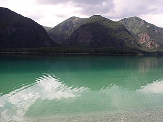
Muncho Lake Provincial Park is a provincial park in British Columbia, Canada, located on the Alaska Highway as it transits the northernmost Canadian Rockies west of Fort Nelson. The park is part of the larger Muskwa-Kechika Management Area. It is named after Muncho Lake, which is in the park and is both the name of the lake and of the community located there.
Woss Lake Provincial Park is a provincial park in British Columbia, Canada, located 75 kilometres southeast of Port McNeill, near the community of Woss, which is also known as Woss Lake.
Tsintsunko Lakes Provincial Park is a 333-hectare provincial park in British Columbia, Canada, located south of the Deadman River between Kamloops (SE) and Bonaparte Lake (NW). It is located on the Bonaparte Plateau. It was established April 30, 1996.

Nazko Cone is a small potentially active basaltic cinder cone in central British Columbia, Canada, located 75 km west of Quesnel and 150 kilometers southwest of Prince George. It is considered the easternmost volcano in the Anahim Volcanic Belt. The small tree-covered cone rises 120 m above the Chilcotin-Nechako Plateau and rests on glacial till. It was formed in three episodes of activity, the first of which took place during the Pleistocene interglacial stage about 340,000 years ago. The second stage produced a large hyaloclastite scoria mound erupted beneath the Cordilleran Ice Sheet during the Pleistocene. Its last eruption produced two small lava flows that traveled 1 km to the west, along with a blanket of volcanic ash that extends several km to the north and east of the cone.

The Ilgachuz Range is a name given to an extinct shield volcano in British Columbia, Canada. It is not a mountain range in the normal sense, because it was formed as a single volcano that has been eroded for the past 5 million years. It lies on the Chilcotin Plateau, located some 350 kilometres (220 mi) north-northwest of Vancouver and 30 km north of Anahim Lake. The highest peak of the range is Far Mountain. The range supports a unique grassland ecosystem. This type of grassland has not been seen anywhere else in central and southern British Columbia. The climate is cool and dry; typical of higher elevations of the Interior Plateau.
The Anahim hotspot is a hypothesized hotspot in the Central Interior of British Columbia, Canada. It has been proposed as the candidate source for volcanism in the Anahim Volcanic Belt, a 300 kilometres long chain of volcanoes and other magmatic features that have undergone erosion. This chain extends from the community of Bella Bella in the west to near the small city of Quesnel in the east. While most volcanoes are created by geological activity at tectonic plate boundaries, the Anahim hotspot is located hundreds of kilometres away from the nearest plate boundary.
Nazko is a small ranching and logging community, including a historic First Nations community located 100 km west of Quesnel on the Nazko River in the Central Interior of British Columbia, Canada. Nazko means, "river flowing from the south".
The Nazko First Nation is a First Nations government of the Dakelh people in the north-central Interior of British Columbia. Its reserves are located around the community of Nazko, British Columbia, which is 120 km west of Quesnel and southwest of Prince George.
A series of small volcanic earthquakes measuring less than 4.0 on the Richter magnitude scale took place in the sparsely populated Nazko area of the Central Interior of British Columbia, Canada, from October 9, 2007, to June 12, 2008. They occurred just west of Nazko Cone, a small tree-covered cinder cone that last erupted about 7,200 years ago.
The Nazko River is a tributary of the West Road River, one of the main tributaries of the Fraser River, in the Canadian province of British Columbia. It flows through the Fraser Plateau region west of Quesnel.


