Marine Protected Areas of Canada

Last updated
The Endeavour Hydrothermal Vents were designated as the first Marine Protected Area of Canada in 2003. Main Endeavour black smoker.jpg
The Endeavour Hydrothermal Vents were designated as the first Marine Protected Area of Canada in 2003.

Marine Protected Areas (MPAs) (French : zones de protection marine) are zones within Canadian waters where the marine environment receives a high level of environmental protection. Marine Protected Areas are governed by the Oceans Act of 1996 and administered by Fisheries and Oceans Canada. [1] The federal government of Canada has committed to protecting 25% of its oceans as Marine Protected Areas by the year 2025, and a further 5% (30% of the ocean area of the Exclusive Economic Zone) by 2030. [2]

Contents

Scope of protection

On 25 April 2019, new standards were adopted for marine protected areas that prohibit four industrial activities: oil and gas activities, mining, dumping, and bottom trawling. These standards do not retroactively void existing oil and gas licenses, or void previously approved bottom trawling activities. Instead, the department will assess each issue of these now prohibited activities on a case-by-case basis to ensure they're in line with the conservation objectives of the specific area. [3] However, designation as a Marine Protected Area does not automatically prohibit fishing and other activities. Activities within these areas are assessed on a case-by-case basis and are permitted if they are consistent with the conservation objectives of the specific area. [1]

Adding to the system

Fisheries and Oceans Canada collaborates with interested and affected parties to provide input into the establishment of a marine protected area. When an area is under consideration to become a marine protected area, it is identified as an Area of Interest. If further study is required to develop an appropriate long-term conservation approach, it is identified as a Study Area. [4]

The department determines the viability of a proposal based upon the ecological, biophysical, social, cultural, and economic aspects of the area. Based on the overview and assessment reports, the conservation objectives of the proposed MPA are elaborated upon and the regulatory measures are developed. The proposal is then published in Canada Gazette, Part I for public comment, at which point regulations may be modified to reflect comments received. Once finalized, official MPA designation occurs when its regulations are published in Canada Gazette, Part II . [4]

List of Marine Protected Areas

As of June 2023, there were 14 Marine Protected Areas covering an area of approximately 351,514 km2 (135,720 sq mi), or about 6% of Canada’s marine and coastal areas. [5]

NameLocationEstablishedArea (km2) [5] Natural region [5] Description
Anguniaqvia niqiqyuam Flag of the Northwest Territories.svg  Northwest Territories 20162,358Western ArcticProtects ecologically important habitats for Arctic char, cod, beluga and bowhead whales, ringed and bearded seals, polar bears, and numerous sea birds. [6]
Banc-des-Américains Flag of Quebec.svg  Quebec 20191,000 Estuary and Gulf of Saint Lawrence Protects the benthic and pelagic ecosystems of an underwater ridge extending southeast from Cap Gaspé.
Basin Head Flag of Prince Edward Island.svg  Prince Edward Island 20059 Estuary and Gulf of Saint Lawrence Protects an underwater ecosystem supporting Irish moss
Eastport Flag of Newfoundland and Labrador.svg  Newfoundland and Labrador 20052Newfoundland-Labrador ShelvesProtects an area of high biological productivity and the spawning grounds of lobster fish. [7]
Endeavour Hydrothermal Vents Flag of British Columbia.svg  British Columbia 200397 Offshore Pacific Protects a collection of hydrothermal vents nestled within the Juan de Fuca Ridge.
Gilbert Bay Flag of Newfoundland and Labrador.svg  Newfoundland and Labrador 200560Newfoundland-Labrador ShelvesProtects a genetically unique resident population of Atlantic cod known as "Gilbert Bay cod". [8]
The Gully Flag of Nova Scotia.svg  Nova Scotia 20042,363 Scotian Shelf Protects a deep submarine canyon ecosystem and endangered cetacean populations in the area.
Hecate Strait and Queen Charlotte Sound Glass Sponge Reefs Flag of British Columbia.svg  British Columbia 20172,410 Northern Shelf Protects four glass sponge reefs that were the first discovered living specimens and are the largest glass sponge reefs in the world.
Laurentian Channel Flag of Newfoundland and Labrador.svg  Newfoundland and Labrador 201911,580Newfoundland-Labrador ShelvesProtects a variety of endangered species within the channel.
Musquash Estuary Flag of New Brunswick.svg  New Brunswick 20067 Scotian Shelf Protects the largest ecologically-intact salt marsh in the Bay of Fundy.
Saint Anns Bank Flag of Nova Scotia.svg  Nova Scotia 20174,364 Scotian Shelf Protects a region of high biodiversity and biological productivity off the east coast of Cape Breton Island.
SGaan Kinghlas-Bowie Seamount Flag of British Columbia.svg  British Columbia 20086,103 Offshore Pacific Protects a unique, biologically diverse marine community of deep sea, subtidal, and intertidal species. [9]
Tarium Niryutait Flag of the Northwest Territories.svg  Northwest Territories
Flag of Yukon.svg  Yukon
20101,750Western ArcticProtects a dynamic, highly productive, and biologically diverse marine ecosystem located within the outer reaches of the Mackenzie River delta. [10]
Tuvaijuittuq Flag of Nunavut.svg  Nunavut 2019319,411 Arctic Basin and Arctic Archipelago Protects a diverse marine ecosystem dependent on thick, multi-year pack ice created by the circulation of the Beaufort Gyre. [11]

Areas of Interest

NameLocationArea (km2) [4] Natural region [4] Description
Eastern Shore IslandsFlag of Nova Scotia.svg  Nova Scotia 2,000 Scotian Shelf A large, highly productive, and ecologically intact stretch of coastline between the villages of Marie Joseph and Jeddore. [12]
Fundian Channel-Browns BankFlag of Nova Scotia.svg  Nova Scotia 7,200 Scotian Shelf Area hosting diverse benthic habitats and depleted fish species. [13]
Northern Gulf of St. LawrenceFlag of Quebec.svg  Quebec TBD [14] Estuary and Gulf of Saint Lawrence
Race Rocks (XwaYeN) Flag of British Columbia.svg  British Columbia 2Southern Shelf [15]
St. Lawrence EstuaryFlag of Quebec.svg  Quebec 6,000 Estuary and Gulf of Saint Lawrence Currently undergoing additional studies to develop an appropriate long-term conservation approach.
Shediac ValleyFlag of New Brunswick.svg  New Brunswick
Flag of Prince Edward Island.svg  Prince Edward Island
1,530 Estuary and Gulf of Saint Lawrence Area of high biological productivity and a key habitat for various fish species. [16]
Southampton IslandFlag of Nunavut.svg  Nunavut 93,087 Hudson Complex Area of high biological productivity. [17]
Tang.ɢwan – ḥačxwiqak – Tsig̱isFlag of British Columbia.svg  British Columbia 133,019 Offshore Pacific To protect seamounts and hydrothermal vents. [18]

See also

Related Research Articles

Fisheries and Oceans Canada is a department of the Government of Canada that is responsible for developing and implementing policies and programs in support of Canada's economic, ecological and scientific interests in oceans and inland waters. Its mandate includes responsibility for the conservation and sustainable use of Canada's fisheries resources while continuing to provide safe, effective and environmentally sound marine services that are responsive to the needs of Canadians in a global economy.

The Gully is a large underwater canyon in the Atlantic Ocean near the edge of the eastern continental shelf of North America. It is located east of Nova Scotia near Sable Island.
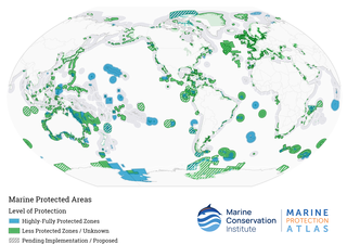
<span class="mw-page-title-main">Marine protected area</span> Protected areas of seas, oceans, estuaries or large lakes

Marine protected areas (MPA) are protected areas of the world's seas, oceans, estuaries or in the US, the Great Lakes. These marine areas can come in many forms ranging from wildlife refuges to research facilities. MPAs restrict human activity for a conservation purpose, typically to protect natural or cultural resources. Such marine resources are protected by local, state, territorial, native, regional, national, or international authorities and differ substantially among and between nations. This variation includes different limitations on development, fishing practices, fishing seasons and catch limits, moorings and bans on removing or disrupting marine life. In some situations, MPAs also provide revenue for countries, potentially equal to the income that they would have if they were to grant companies permissions to fish. The value of MPA to mobile species is unknown.

<span class="mw-page-title-main">Protected areas of Canada</span> Areas protected for conservation or historical reasons

Protected areas of Canada consist of approximately 12.1 percent of the nation's landmass and freshwater are considered conservation areas, including 11.4 percent designated as protected areas. Approximately 13.8 percent of Canada's territorial waters are conserved, including 8.9 percent designated as protected areas. Terrestrial areas conserved have increased by 65 percent in the 21st century, while marine areas conserved have increased by more than 3,800 percent.

<span class="mw-page-title-main">Salish Sea</span> Marginal sea in British Columbia and Washington state

The Salish Sea is a marginal sea of the Pacific Ocean located in the Canadian province of British Columbia and the U.S. state of Washington. It includes the Strait of Georgia, the Strait of Juan de Fuca, Puget Sound, and an intricate network of connecting channels and adjoining waterways.

<span class="mw-page-title-main">Laurentian Channel</span> Undersea Feature, Valley in Gulf of Saint Lawrence

The Laurentian Channel is a deep submarine valley off the coast of eastern Canada in the Gulf of Saint Lawrence.

<span class="mw-page-title-main">Sponge reef</span>

Sponge reefs are reefs produced by sea sponges. All modern sponge reefs are formed by hexactinellid sponges, which have an endoskeleton made of silica spicules and are often referred to as "glass sponges", while historically the non-spiculed, calcite-skeletoned archaeocyathid and stromatoporoid sponges were the primariy reef-builders.

<span class="mw-page-title-main">Fishing industry in Canada</span>

Canada's fishing industry is a key contributor to the success of the Canadian economy. In 2018, Canada's fishing industry was worth $36.1 billion in fish and seafood products and employed approximately 300,000 people. Aquaculture, which is the farming of fish, shellfish, and aquatic plants in fresh or salt water, is the fastest growing food production activity in the world and a growing sector in Canada. In 2015, aquaculture generated over $1 billion in GDP and close to $3 billion in total economic activity. The Department Of Fisheries and Oceans (DFO) oversees the management of Canada's aquatic resources and works with fishermen across the country to ensure the sustainability of Canada's oceans and in-land fisheries.

<span class="mw-page-title-main">Pacific North Coast Integrated Management Area</span>

The Pacific North Coast Integrated Management Area is one of five Large Ocean Management Areas (LOMAs), areas of high ecological, social and economic importance, that have been identified by Fisheries and Oceans Canada (DFO) as priority regions for marine planning as part of Canada’s Oceans Action Plan.

<span class="mw-page-title-main">Aquatic invasive species in Canada</span>

Canadian aquatic invasive species are all forms of life that traditionally has not been native to Canada's waterways. In Eastern Canada, non-native plant and animal species are a concern to biologists. Bringing non-native species such as invasive fishes into Canada can damage the environment and ecosystem by repressing native species due to food competition or preying. Invasive fishes enter the fresh waters of Canada in several ways including drifting, deliberate introduction, accidental release, experimental purposes and, most commonly, through the attachment on international boat hulls. Invasive species are the second biggest threat to fish and other marine life in Canada behind loss of habitat and degradation. The threat to native species is primarily caused by impacts on the food web; however, invasive species also bring dangerous pathogens and physically interfere with existing aquatic life. Invasive species include sea lampreys, zebra mussels, smallmouth bass, European green crab, vase tunicate, and sea squirts.

<i>Sebastes reedi</i> Species of fish

Sebastes reedi the yellowmouth rockfish, is a species of marine ray-finned fish belonging to the subfamily Sebastinae, the rockfishes, part of the family Scorpaenidae. It is found in the Eastern Pacific.

The marine protected areas of South Africa are in an area of coastline or ocean within the exclusive economic zone (EEZ) of the Republic of South Africa that is protected in terms of specific legislation for the benefit of the environment and the people who live in and use it. An MPA is a place where marine life can thrive under less pressure than unprotected areas. They are like underwater parks, and this healthy environment can benefit neighbouring areas.

The Margaree Salmon Association is a wildlife conservation group that was established in 1982 in Margaree, Cape Breton Island, Nova Scotia, Canada. The association is a nonprofit organization, that dedicates itself to restoration ecology, through conservation, protection and enhancement of spawning and rearing habitat of the salmonid lineage; specific to the Atlantic salmon and trout species. The association engineers habitat enhancing structures into tributaries of the Margaree River watershed. The Margaree River is public domain, attracting yearly visits by anglers near and far. The Association was involved in the nomination and designation of the Margaree River-Lake Ainslie watershed; as a Canadian Heritage Rivers System. As well, the Association works in collaboration with the Inland Fisheries Division of the Nova Scotia Department of Fisheries and Aquaculture and Fisheries and Oceans Canada, to assist with scientific study in areas of broodstock collection, stock assessment and water quality sampling.

<span class="mw-page-title-main">Hecate Strait and Queen Charlotte Sound Glass Sponge Reefs Marine Protected Area</span> Protected marine area in British Columbia

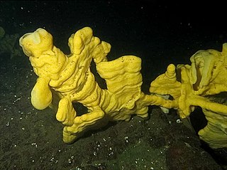
Hecate Strait and Queen Charlotte Sound Glass Sponge Reefs Marine Protected Area is a 2,410-square-kilometre marine protected area located in Hecate Strait and Queen Charlotte Sound off the North Coast of British Columbia, Canada. The marine protected area was established in February 2017 with the goal of conserving the biological diversity, structural habitat, and ecosystem function of four glass sponge reefs. These reefs were the first discovered living specimens and are the largest glass sponge reefs in the world.

<span class="mw-page-title-main">Tuvaijuittuq Marine Protected Area</span> Nature reserve in Canada

Tuvaijuittuq Marine Protected Area is a marine protected area located off the northwest coast of Ellesmere Island in Nunavut, Canada. The goal of the marine protected area is to protect the rich biodiversity and dynamism of the High Arctic sea ice ecosystem. Covering an area of 319,411 square kilometres (123,325 sq mi), Tuvaijuittuq is the largest protected area in Canada and among the largest protected areas in the world. It is part of a large oceanic region referred to as the Last Ice Area, located adjacent to the coasts of northern Greenland and the Canadian Arctic Archipelago, which contain and accumulate the oldest remaining sea ice in the Arctic.

<i>Fisheries Act</i> (Canada)

The Fisheries Act is legislation enacted by the Parliament of Canada, governing the powers of government to regulate fisheries and fishing vessels. The act has been undergoing major regulatory revisions in recent years, including those attached to treaty rights of Miꞌkmaq in Atlantic Canada. The Minister designated under the Act is the Ministers of Fisheries, Oceans and the Canadian Coast Guard.

<span class="mw-page-title-main">Tarium Niryutait Marine Protected Area</span> Canadian Arctic Marine Protected Area

Tarium Niryutait is a marine protected area (MPA) located in the coastal areas of the Yukon and Northwest Territories in Canada. It is located within the Inuvialuit Settlement Region and was the first Arctic MPA established in Canada. The MPA was established with the goal of protecting Beluga whales and the biodiversity of other bird and fish species and their habitats.

<span class="mw-page-title-main">Anguniaqvia niqiqyuam Marine Protected Area</span>

The Anguniaqvia niqiqyuam Marine Protected Area (MPA) is located in the Inuvialuit Settlement Region in the Northwest Territories, Canada. The MPA was established in October 2016 to support habitat for important marine species, and to help protect the marine environment adjacent to the Cape Parry Migratory Bird Sanctuary. The area is culturally important to the Inuvialuit for subsistence hunting and fishing activities. The MPA was named in honour of Nelson Green, an Inuvialuit elder from Paulatuk.

<span class="mw-page-title-main">Gwaxdlala/Nalaxdlala (Lull/Hoeya) Marine Refuge</span> Marine refuge in British Columbia, Canada

The Gwaxdlala/Nalaxdlala (Lull/Hoeya) Marine Refuge is located in Knight Bay on the Central Coast of British Columbia and encompasses Lull Bay, Hoeya Sound and their corresponding watersheds. This Marine Refuge was created in partnership by the Mamalilikulla First Nation and the British Columbia Provincial Government. It was officially established on November 29, 2021, by the Mamalilikulla First Nation. The Lull/Hoeya Marine Refuge was created with the purpose of protecting biodiversity, endangered species, Indigenous culture and heritage, in an area with unique physical geography and oceanography.

References

  1. 1 2 Government of Canada, Fisheries and Oceans Canada (2018-03-05). "About Marine Protected Areas". www.dfo-mpo.gc.ca. Retrieved 2020-09-13.
  2. Government of Canada, Fisheries and Oceans Canada (2023-05-09). "Canada's Oceans: Protecting and conserving marine and coastal areas". www.dfo-mpo.gc.ca. Retrieved 2023-06-02.
  3. Government of Canada, Fisheries and Oceans Canada (2019-04-25). "Protection Standards to better conserve our oceans". www.dfo-mpo.gc.ca. Retrieved 2020-09-13.
  4. 1 2 3 4 Government of Canada, Fisheries and Oceans Canada (2019-11-22). "Establishing new Marine Protected Areas". www.dfo-mpo.gc.ca. Retrieved 2020-09-15.
  5. 1 2 3 Government of Canada, Fisheries and Oceans Canada (2019-11-22). "Marine Protected Areas across Canada". www.dfo-mpo.gc.ca. Retrieved 2020-09-13.
  6. Government of Canada, Fisheries and Oceans Canada (2019-09-18). "Anguniaqvia niqiqyuam Marine Protected Area (MPA)". www.dfo-mpo.gc.ca. Retrieved 2020-09-14.
  7. Government of Canada, Fisheries and Oceans Canada (2019-09-18). "Eastport Marine Protected Area (MPA)". www.dfo-mpo.gc.ca. Retrieved 2020-09-14.
  8. Government of Canada, Fisheries and Oceans Canada (2019-09-18). "Gilbert Bay Marine Protected Area (MPA)". www.dfo-mpo.gc.ca. Retrieved 2020-09-13.
  9. Government of Canada, Fisheries and Oceans Canada (2019-09-18). "SGaan Kinghlas-Bowie Seamount Marine Protected Area (SK-B MPA)". www.dfo-mpo.gc.ca. Retrieved 2020-09-14.
  10. Government of Canada, Fisheries and Oceans Canada (2019-09-18). "Tarium Niryutait Marine Protected Area (TN MPA)". www.dfo-mpo.gc.ca. Retrieved 2020-09-14.
  11. Government of Canada, Fisheries and Oceans Canada (2019-09-18). "Tuvaijuittuq Marine Protected Area (MPA)". www.dfo-mpo.gc.ca. Retrieved 2020-09-14.
  12. Government of Canada, Fisheries and Oceans Canada (2019-08-27). "Eastern Shore Islands: Area of Interest (AOI)". www.dfo-mpo.gc.ca. Retrieved 2020-09-13.
  13. Government of Canada, Fisheries and Oceans Canada (2018-05-07). "Fundian Channel-Browns Bank Area of Interest (AOI)". www.dfo-mpo.gc.ca. Retrieved 2020-09-13.
  14. Government of Canada, Fisheries and Oceans Canada (2019-09-06). "Protection of the marine environment under the Canada-Quebec Collaborative Agreement". www.dfo-mpo.gc.ca. Retrieved 2020-09-13.
  15. "Race Rocks Ecological Reserve". B.C. Parks. Retrieved 2023-06-11.
  16. Government of Canada, Fisheries and Oceans Canada (2017-09-28). "Shediac Valley Area of Interest (AOI)". www.dfo-mpo.gc.ca. Retrieved 2020-09-13.
  17. Government of Canada, Fisheries and Oceans Canada (2019-08-26). "Southampton Island Area of Interest (AOI)". www.dfo-mpo.gc.ca. Retrieved 2020-09-13.
  18. Government of Canada, Fisheries and Oceans Canada (2023-02-18). "Tang.ɢwan – ḥačxwiqak – Tsig̱is Area of Interest (TḥT AOI)". www.dfo-mpo.gc.ca. Retrieved 2023-06-02.