
The Gulf of St. Lawrence fringes the shores of the provinces of Quebec, New Brunswick, Nova Scotia, Prince Edward Island, Newfoundland and Labrador, in Canada, plus the islands Saint-Pierre and Miquelon, possessions of France, in North America.

The Honguedo Strait, the toponym designates the wide passage of the Gulf of St. Lawrence between the Gaspésie peninsula and Anticosti Island, Quebec, Canada.

The Atlantic wolffish, also known as the seawolf, Atlantic catfish, ocean catfish, devil fish, wolf eel, woof or sea cat, is a marine fish of the wolffish family Anarhichadidae, native to the North Atlantic Ocean. The numbers of the Atlantic wolffish in US waters are rapidly being depleted, most likely due to overfishing and bycatch, and it is currently a Species of Concern according to the U.S. National Oceanic and Atmospheric Administration's National Marine Fisheries Service.

The Channel Islands National Marine Sanctuary is a sanctuary off the coast of Santa Barbara and Ventura counties in Southern California 350 miles (563 km) south of San Francisco and 95 miles (153 km) north of Los Angeles. It was designated on October 2, 1980, by the National Oceanic and Atmospheric Administration and was expanded in 2007.

A marine reserve is a type of marine protected area (MPA). An MPA is a section of the ocean where a government has placed limits on human activity. A marine reserve is a marine protected area in which removing or destroying natural or cultural resources is prohibited, marine reserves may also be "no-take MPAs,” which strictly forbid all extractive activities, such as fishing and kelp harvesting. As of 2007 less than 1% of the world's oceans had been set aside in marine reserves. Benefits include increases in the diversity, density, biomass, body size and reproductive potential of fishery and other species within their boundaries.

The porbeagle or porbeagle shark is a species of mackerel shark in the family Lamnidae, distributed widely in the cold and temperate marine waters of the North Atlantic and Southern Hemisphere. In the North Pacific, its ecological equivalent is the closely related salmon shark (L. ditropis). It typically reaches 2.5 m (8.2 ft) in length and a weight of 135 kg (298 lb); North Atlantic sharks grow larger than Southern Hemisphere sharks and differ in coloration and aspects of life history. Gray above and white below, the porbeagle has a very stout midsection that tapers towards the long, pointed snout and the narrow base of the tail. It has large pectoral and first dorsal fins, tiny pelvic, second dorsal, and anal fins, and a crescent-shaped caudal fin. The most distinctive features of this species are its three-cusped teeth, the white blotch at the aft base of its first dorsal fin, and the two pairs of lateral keels on its tail.
Fisheries and Oceans Canada is a department of the Government of Canada that is responsible for developing and implementing policies and programs in support of Canada's economic, ecological and scientific interests in oceans and inland waters. Its mandate includes responsibility for the conservation and sustainable use of Canada's fisheries resources while continuing to provide safe, effective and environmentally sound marine services that are responsive to the needs of Canadians in a global economy.
The Gully is a large underwater canyon in the Atlantic Ocean near the edge of the eastern continental shelf of North America. It is located east of Nova Scotia near Sable Island.
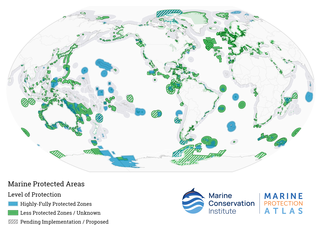
Marine protected areas (MPAs) are protected areas of the world's seas, oceans, estuaries or in the US, the Great Lakes. These marine areas can come in many forms ranging from wildlife refuges to research facilities. MPAs restrict human activity for a conservation purpose, typically to protect natural or cultural resources. Such marine resources are protected by local, state, territorial, native, regional, national, or international authorities and differ substantially among and between nations. This variation includes different limitations on development, fishing practices, fishing seasons and catch limits, moorings and bans on removing or disrupting marine life. MPAs can provide economic benefits by supporting the fishing industry through the revival of fish stocks, as well as job creation and other market benefits via ecotourism. The value of MPA to mobile species is unknown.

Sodwana Bay is a bay in South Africa on the KwaZulu Natal north coast, between St. Lucia and Lake Sibhayi. It is in the Sodwana Bay National Park, and the Maputaland Marine Reserve, and is a popular recreational diving destination. The term is commonly used to refer to both the marine reserve and the terrestrial park, as well as the geographical bay.

The northern wolffish, also known as the blue sea cat or jelly cat, is a species of marine ray-finned fish belonging to the family Anarhichadidae, the wolf fishes. This species is found in the North Atlantic Ocean and Arctic Ocean.

As with other countries, the 200 nautical miles (370 km) exclusive economic zone (EEZ) off the coast of the United States gives its fishing industry special fishing rights. It covers 11.4 million square kilometres, which is the second largest zone in the world, exceeding the land area of the United States.

In 1992, Northern Cod populations fell to 1% of historical levels, due in large part to decades of overfishing. The Canadian Federal Minister of Fisheries and Oceans, John Crosbie, declared a moratorium on the Northern Cod fishery, which for the preceding 500 years had primarily shaped the lives and communities of Canada's eastern coast. A significant factor contributing to the depletion of the cod stocks off Newfoundland's shores was the introduction of equipment and technology that increased landed fish volume. From the 1950s onwards, new technology allowed fishers to trawl a larger area, fish more in-depth, and for a longer time, with the catches peaking in the 1970s and 1980s. Cod stocks were depleted at a faster rate than could be replenished.

Cod fisheries are fisheries for cod. Cod is the common name for fish of the genus Gadus, belonging to the family Gadidae, and this article is confined to three species that belong to this genus: the Atlantic cod, the Pacific cod and the Greenland cod. Although there is a fourth species of the cod genus Gadus, Alaska pollock, it is commonly not called cod and therefore currently not covered here.

The Pacific spiny dogfish is a common species of the Squalidae (dogfish) family of sharks and are among the most abundant species of sharks in the world. This species is closely related to Squalus acanthias and for many years they were treated as a single species. Recent research, using meristic, morphological and molecular data led to the resurrection of the Pacific spiny dogfish as a separate species. The American Fisheries Society recommends the common name "Pacific spiny dogfish" for Squalus suckleyi over alternatives such as "spotted spiny dogfish" and "North Pacific spiny dogfish" and "spiny dogfish" for Squalus acanthias.
The marine protected areas of South Africa are in an area of coastline or ocean within the exclusive economic zone (EEZ) of the Republic of South Africa that is protected in terms of specific legislation for the benefit of the environment and the people who live in and use it. An MPA is a place where marine life can thrive under less pressure than unprotected areas. They are like underwater parks, and this healthy environment can benefit neighbouring areas.

Marine Protected Areas (MPAs) (French: zones de protection marine) are zones within Canadian waters where the marine environment receives a high level of environmental protection. Marine Protected Areas are governed by the Oceans Act of 1996 and administered by Fisheries and Oceans Canada. The federal government of Canada has committed to protecting 25% of its oceans as Marine Protected Areas by the year 2025, and a further 5% (30% of the ocean area of the Exclusive Economic Zone) by 2030.

The Fisheries Act is legislation enacted by the Parliament of Canada, governing the powers of government to regulate fisheries and fishing vessels. The act has been undergoing major regulatory revisions in recent years, including those attached to treaty rights of Miꞌkmaq in Atlantic Canada. The Minister designated under the Act is the Ministers of Fisheries, Oceans and the Canadian Coast Guard.
The Gwaxdlala/Nalaxdlala (Lull/Hoeya) Marine Refuge is located in Knight Bay on the Central Coast of British Columbia and encompasses Lull Bay, Hoeya Sound and their corresponding watersheds. This Marine Refuge was created in partnership by the Mamalilikulla First Nation and the British Columbia Provincial Government. It was officially established on November 29, 2021, by the Mamalilikulla First Nation. The Lull/Hoeya Marine Refuge was created with the purpose of protecting biodiversity, endangered species, Indigenous culture and heritage, in an area with unique physical geography and oceanography.

