Exclusive economic zone of Canada

Last updated
Canada's exclusive economic zone and territorial waters Canada Exclusive Economic Zone.PNG
Canada's exclusive economic zone and territorial waters

The exclusive economic zone of Canada is the area of the sea in which Canada has special rights regarding the exploration and use of marine resources, as prescribed by the 1982 United Nations Convention on the Law of the Sea. [1]

Contents

Canada's exclusive economic zone (EEZ) is the 7th largest in the world. [2] It is unusual in that its EEZ, covering 5,599,077 km2 (2,161,816 sq mi), is slightly smaller than its territorial waters. [3] The latter generally extend only 12 Nautical miles from the shore, but also include inland marine waters such as Hudson Bay—about 300 nautical miles (560 km; 350 mi) across—the Gulf of Saint Lawrence, and the internal waters of the Arctic archipelago.

Geography

Canada's EEZ is in the Pacific Ocean, Beaufort Sea, Arctic Ocean, Baffin Bay, Hudson Bay, Labrador Sea, Northwestern Passages, Gulf of St Lawrence, and the Atlantic Ocean. It borders with Alaska (US) to the west, Greenland to the east, and the United States to the south.

The fishing grounds in Canada's Atlantic Ocean zone are called the "Grand Banks". They extend beyond 200 nautical miles (370 km; 230 mi) in the northern area called the "Nose" and the southern area called the "Tail" of the Grand Banks. The fish habitat outside 200 nmi encompasses 327,000 square nautical miles (1,120,000 km2; 433,000 sq mi), compared to 673,000 sq nmi (2,310,000 km2; 891,000 sq mi) landwards in the limited area. [4]

Marine life

In 1973, the waters within 200 nautical miles, produced over 90% of the world's marine fish catches of 66 million metric tons, even if they only include 30% of the world's oceans and seas. [5]

There are issues with how to manage straddling and migratory fish stocks which are vulnerable for high seas fisheries that operate outside the EEZ. The increase in fish catches within the EEZ and outside cause overfishing and decline of major stock levels. Fish catches by foreign fleets outside Canada's EEZ became a significant problem during the 1980s and 1990s. International agreements were made with most fishing states which placed moratoriums on nearly all traditional Fish stocks. In the mid-1990s a conflict arose about a specific stock between Canada and the European Union. Canadian authorities arrested a vessel from the European Union in the mid-1990s. There was a Canadian initiative to resolve this global problem which gained enough support from other countries for another United Nations Conference. This resulted in a United Nations Convention to straddle the highly migratory fish stocks. It was adopted in 1995, but requires 30 ratifications to be enforced. [6] Another problem is salmon are not protected by UNCLOS from competitive fishing while the salmon migrates through the rivers and lakes of different coastal states to their spawning grounds. In some areas the issue of foreign fleets maximizing their catches on the high seas was replaced by coastal fisheries trying to do the same. There is a need for the implementation of effective policies to manage fisheries. [7]

History

In 1945, there were two United States presidential proclamations called the "Truman Proclamations". One was about how to manage the continental shelf and the other about fisheries. [8] This caused a fast erosion of the concept "freedom of the seas" (all countries can freely use the oceans for navigation and fishing). Thereafter, many countries claimed resource rights with a maximum of 200 nautical miles. [9]

The Canadian coastal areas in the Pacific and Atlantic contain among the richest fish resources in the world. In 1973 Canada's east coast territorial sea and fishing zones was 70,600 sq mi (183,000 km2). Thanks to the extension to 200 nautical miles it increased to 673,000 sq mi (1,740,000 km2). This encompassed 96% of the total fish catch by Canadian and foreign fishing fleets in the Atlantic zone of Canada. The marine life and natural resources in the Atlantic zone of Canada caused many foreign fishing vessels to exploit it. Since 1958 there was a dramatic increase of vessels from East Europe who joined West Europeans while the Canadian fishing fleet remained a stable size. [10]

The Canadian and foreign fish catches were in danger due to significant stock declines since the early '70s. [11] The International Commission for the Northwest Atlantic Fisheries (ICNAF) which existed since the 1940s could not prevent the rapid decline of fish stock. [12]

In 1973, Canada participated in the Third United Nations Conference on the Law of the Sea. [13] UNCLOS became effective since 16 November 1982. The Exclusive Economic Zone section of UNCLOS is described in Part V. It provides a "comprehensive framework for contemporary uses of the sea." It is the result of 15 years of negotiations which were initiated by the United Nations Seabed Committee and then at UNCLOS III. [14]

Before the 200 nautical mile limit was accepted only 4% of the fish catch occurred outside the limit off Canada's Atlantic coast by Canadian and all foreign fleets. [15]

In the Pacific, the Canadian territorial sea and fishing zones expanded from 46,600 sq mi (121,000 km2) to 135,546 sq mi (351,060 km2). [16]

The EEZ encompass all waters seaward of the territorial sea limits to a distance of 200 nautical miles. All countries still have numerous high seas rights for transit and communication. [17] In 1994, the Convention was adopted after the deposit of the minimum 60 ratifications. [18]

Disputes

Active

Resolved

In 1992, the Canada–France Maritime Boundary Case, which centered on the EEZ around the French islands of Saint Pierre and Miquelon, was decided by an arbitral tribunal which concurred on the whole with the arguments put forth by Canada. France was awarded 18% of the area it had originally claimed.

See also

Related Research Articles

<span class="mw-page-title-main">United Nations Convention on the Law of the Sea</span> International maritime law

The United Nations Convention on the Law of the Sea (UNCLOS), also called the Law of the Sea Convention or the Law of the Sea Treaty, is an international agreement that establishes a legal framework for all marine and maritime activities. As of May 2023, 168 countries and the European Union are parties.

<span class="mw-page-title-main">Grand Banks of Newfoundland</span> Group of underwater plateaus south-east of Newfoundland, Canada

The Grand Banks of Newfoundland are a series of underwater plateaus south-east of the island of Newfoundland on the North American continental shelf. The Grand Banks are one of the world's richest fishing grounds, supporting Atlantic cod, swordfish, haddock and capelin, as well as shellfish, seabirds and sea mammals.

<span class="mw-page-title-main">International waters</span> Water outside of national jurisdiction

The terms international waters or transboundary waters apply where any of the following types of bodies of water transcend international boundaries: oceans, large marine ecosystems, enclosed or semi-enclosed regional seas and estuaries, rivers, lakes, groundwater systems (aquifers), and wetlands.

<span class="mw-page-title-main">Territorial waters</span> Coastal waters that are part of a sovereign states sovereign territory

Territorial waters are informally an area of water where a sovereign state has jurisdiction, including internal waters, the territorial sea, the contiguous zone, the exclusive economic zone, and potentially the extended continental shelf. In a narrower sense, the term is often used as a synonym for the territorial sea.

<span class="mw-page-title-main">Law of the sea</span> International law concerning maritime environments

Law of the sea is a body of international law governing the rights and duties of states in maritime environments. It concerns matters such as navigational rights, sea mineral claims, and coastal waters jurisdiction.

<span class="mw-page-title-main">Exclusive economic zone</span> Adjacent sea zone in which a state has special rights

An exclusive economic zone (EEZ), as prescribed by the 1982 United Nations Convention on the Law of the Sea, is an area of the sea in which a sovereign state has exclusive rights regarding the exploration and use of marine resources, including energy production from water and wind. EEZ does not define the ownership of any maritime features within the EEZ.

<span class="mw-page-title-main">Turbot War</span> 1994–96 dispute between Canada and Spain

The Turbot War was an international fishing dispute and bloodless conflict between Canada and Spain and their respective supporters.

<span class="mw-page-title-main">Territorial claims in the Arctic</span>

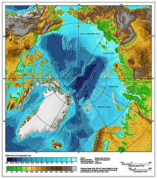
The Arctic consists of land, internal waters, territorial seas, exclusive economic zones (EEZs) and international waters above the Arctic Circle. All land, internal waters, territorial seas and EEZs in the Arctic are under the jurisdiction of one of the eight Arctic coastal states: Canada, Denmark, Finland, Iceland, Norway, Russia, Sweden and the United States. International law regulates this area as with other portions of Earth.

The South East Atlantic Fisheries Organisation (SEAFO) is an organization that maintains controls over fishing and fishing related acts in the Southeastern Atlantic Ocean.

<span class="mw-page-title-main">Fishing industry in New Zealand</span>

As with other countries, New Zealand's 200 nautical miles exclusive economic zone gives its fishing industry special fishing rights. It covers 4.1 million square kilometres. This is the sixth largest zone in the world, and is fourteen times the land area of New Zealand.

<span class="mw-page-title-main">Fishing industry in the United States</span>

As with other countries, the 200 nautical miles (370 km) exclusive economic zone (EEZ) off the coast of the United States gives its fishing industry special fishing rights. It covers 11.4 million square kilometres, which is the second largest zone in the world, exceeding the land area of the United States.

<span class="mw-page-title-main">Exclusive economic zone of Somalia</span>

The exclusive economic zone of Somalia covers 830,389 km2 in the Indian Ocean. It extends to a distance of 200 nautical miles from the baselines, from which the breadth of the nation's territorial waters is measured. In accordance with Law No. 37 passed in 1972, Somalia's EEZ falls under its territorial sovereignty.

<span class="mw-page-title-main">Marine policy of the Barack Obama administration</span>

The Marine Policy of the Barack Obama administration comprises several significant environmental policy decisions for the oceans made during his two terms in office from 2009 to 2017. By executive action, US President Barack Obama increased fourfold the amount of protected marine space in waters under United States control, setting a major precedent for global ocean conservation. Using the U.S. president's authority under the Antiquities Act of 1906, he expanded to 200 nautical miles the seaward limits of Papahānaumokuākea Marine National Monument in Hawaiʻi and the Pacific Remote Islands Marine National Monument around the U.S. island possessions in the Central Pacific. In the Atlantic, Obama created the Northeast Canyons and Seamounts Marine National Monument, the first marine monument in the U.S. exclusive economic zone (EEZ) in the Atlantic.

<span class="mw-page-title-main">Exclusive economic zone of Japan</span> Economic zone exclusive to Japan

Japan has the eighth-largest exclusive economic zone (EEZ) in the world. The total area of Japan is about 380 thousand km2. Japan's EEZ area is vast and the territorial waters and EEZ together is about 4.47 million km2.

Illegal, unreported and unregulated fishing (IUU) in the Arctic is an under researched scientific field. The most recent academic articles about IUU in the Arctic mainly concerns the mid-2000s.

<span class="mw-page-title-main">Exclusive economic zone of Vietnam</span> Economic zone exclusive to Vietnam

Vietnam claims an exclusive economic zone (EEZ) of 1,395,096 km2 (538,650 sq mi) with 200 nautical miles from its shores.

Malaysia claims an exclusive economic zone (EEZ) of 334,671 km2 (129,217 sq mi) with 200 nautical miles from its shores. The EEZ includes much of the southern area of the South China Sea. Malaysia has the 29th longest coastline of 4,675 km (2,905 mi). The coastline comprises two distinct parts of Malaysia. The Peninsular Malaysia's coastline to the west is 2,068 km (1,285 mi) and East Malaysia's coastline is 2,607 km (1,620 mi). They are separated by the South China Sea. The total land area, including inland bodies of water, of Malaysia is 330,803 km2 (127,724 sq mi). Peninsular Malaysia borders Thailand in the north, while East Malaysia borders Brunei and Indonesia on the island of Borneo.

<span class="mw-page-title-main">Exclusive economic zone of Indonesia</span> Areas of the sea in which Indonesia has special rights

Indonesia has the sixth-largest exclusive economic zone in the world with 6,159,032 km2 (2,378,016 sq mi). It claims an EEZ of 200 nautical miles (370 km) from its shores. This is due to the 13,466 islands of the Indonesian archipelago. It has the 3rd largest coastline of 54,720 km (34,000 mi). It is located in Southeast Asia between the Indian Ocean and the Pacific Ocean.

<span class="mw-page-title-main">Exclusive economic zone of India</span> Economic zone exclusive to India

India has the 18th-largest exclusive economic zone (EEZ) with a total size of 2,305,143 km2 (890,021 sq mi). It includes the Lakshadweep island group in the Laccadive Sea off the southwestern coast of India and the Andaman and Nicobar Islands in the Bay of Bengal and the Andaman Sea. India's EEZ is bordered to the west by Pakistan, to the south by the Maldives and Sri Lanka and to the east by Bangladesh, Myanmar, Thailand, Malaysia and Indonesia. Based on new scientific data, India has petitioned United Nations to extend its EEZ from 200 Nautical miles to 500 miles.

<span class="mw-page-title-main">Niue Nukutuluea Multiple-Use Marine Park</span> Marine protected area in Niue

The Niue Nukutuluea Multiple-Use Marine Park is a marine protected area that encompasses the territorial waters and exclusive economic zone surrounding the Pacific island of Niue, covering a total area of 318,140 square kilometres (122,830 sq mi). Established in April 2022, it incorporated the Niue Moana Mahu Marine Protected Area and Beveridge Reef Nukutulueatama Special Management Area, which had been established in April 2020.

References

    1. "PREAMBLE TO THE UNITED NATIONS CONVENTION ON THE LAW OF THE SEA". www.un.org. Retrieved 27 September 2021.
    2. "Sea Around Us – Fisheries, Ecosystems and Biodiversity" . Retrieved 1 April 2017.
    3. "Canada's Marine Waters: Integrating the Boundaries of Politics and Nature]". Wildlife Habitat Canada. Archived from the original on 21 December 2005.
    4. C. L. Mitchell, Canada's Law of the Sea Position, The Economic Implications, unpublished paper, 1974, Library of the Department of Fisheries and Oceans, Ottawa, pp.30.
    5. "Law Of The Sea – The Exclusive Economic Zone". Canadian Museum of History. Archived from the original on 4 December 2018. Retrieved 30 August 2020.
    6. Agreement for the Implementation of the Provisions of the United Nations Convention on the Law of the Sea of 10 December 1982 Relating to the Conservation and Management of Straddling Fish Stocks and Highly Migratory Fish Stocks adopted 4 August 1995 by the United Nations Conference on Straddling Fish Stocks and Highly Migratory Fish Stocks, United Nations Publications, New York 1995.
    7. A. H. Hoel, Performance of Exclusive Economic Zone, Dartmouth College Hanover New Hampshire U.S.A., Institutional Dimensions of Global Environmental Change. Scoping Report No. 2, July 2000, p.i.
    8. R. D. Eckert, The Enclosure of Ocean Resources, Hoover Institution Press, 1979, p.3 and pp.128–129.
    9. R. D. Eckert, The Enclosure of Ocean Resources, Hoover Institution Press, 1979, p.4.
    10. S. Parsons, Management of Marine Fisheries in Canada, National Research Council of Canada, 1993, p.228.
    11. S. Parsons, Management of Marine Fisheries in Canada, National Research Council of Canada, 1993, p.229.
    12. S. Parsons, Management of Marine Fisheries in Canada, National Research Council of Canada, 1993, p.239.
    13. United Nations Convention on the Law of the Sea (UNCLOS), United Nations, New York 1983.
    14. B. Kwiatowska, The 200 Mile Exclusive Economic Zone in the New Law of the Sea, Martinus Nijhoff Publishers, 1989, p.xx.
    15. C. L. Mitchell, Canada's Law of the Sea Position, The Economic Implications, unpublished paper, 1974, Library of the Department of Fisheries and Oceans, Ottawa, pp.30–31.
    16. C. L. Mitchell, Canada's Law of the Sea Position, The Economic Implications, unpublished paper, 1974, Library of the Department of Fisheries and Oceans, Ottawa, pp.27–30, 32.
    17. B. Kwiatowska, The 200 Mile Exclusive Economic Zone in the New Law of the Sea, Martinus Nijhoff Publishers, 1989, p.x.
    18. E. L. Miles, Global Ocean Politics, Kluwer Law International, 1998, p.3.