
The United Nations Convention on the Law of the Sea (UNCLOS), also called the Law of the Sea Convention or the Law of the Sea Treaty, is an international treaty that establishes a legal framework for all marine and maritime activities. As of October 2024, 169 States and the European Union are parties.

Territorial waters are informally an area of water where a sovereign state has jurisdiction, including internal waters, the territorial sea, the contiguous zone, the exclusive economic zone, and potentially the extended continental shelf. In a narrower sense, the term is often used as a synonym for the territorial sea.

An exclusive economic zone (EEZ), as prescribed by the 1982 United Nations Convention on the Law of the Sea, is an area of the sea in which a sovereign state has exclusive rights regarding the exploration and use of marine resources, including energy production from water and wind.

The Chilean Sea is the portion of the Pacific Ocean lying west of the Chilean mainland. The official Chilean usage for Chilean Sea was defined on 30 May 1974 when the Diario oficial de la Republica de Chile published Supreme Decree #346, which declared that "the waters surrounding or touching the shores of the national territory shall be known as Mar Chileno."
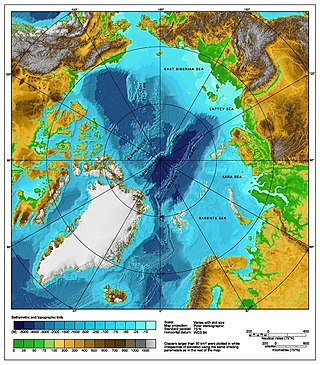
The Arctic consists of land, internal waters, territorial seas, exclusive economic zones (EEZs) and international waters above the Arctic Circle. All land, internal waters, territorial seas and EEZs in the Arctic are under the jurisdiction of one of the eight Arctic coastal states: Canada, Denmark, Finland, Iceland, Norway, Russia, Sweden and the United States. International law regulates this area as with other portions of Earth.
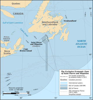
The Canada–France Maritime Boundary Case was a dispute between Canada and France that was decided in 1992 by an arbitral tribunal created by the parties to resolve the dispute. The decision established the extent of the Exclusive Economic Zone of the French territory of Saint Pierre and Miquelon.

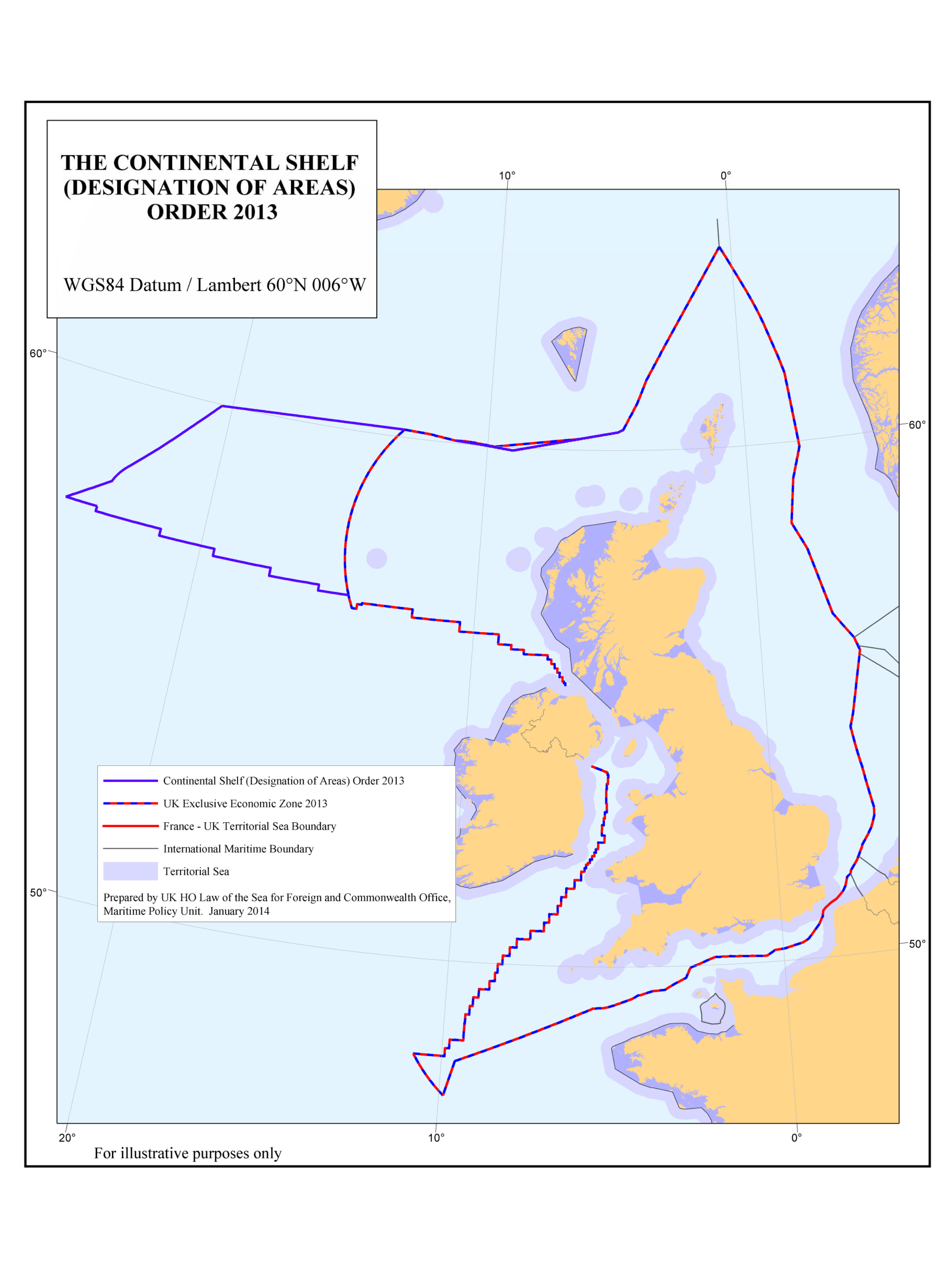
The Marine and Coastal Access Act 2009 is an act of the Parliament of the United Kingdom. It creates "a new system of marine management".

The Republic of Cyprus (Cyprus) and Turkey have been engaged in a dispute over the extent of their exclusive economic zones (EEZ), ostensibly sparked by oil and gas exploration in the area. Turkey objects to Cypriot drilling in waters that Cyprus has asserted a claim on. The present maritime zones dispute touches on the perennial Cyprus and Aegean disputes; Turkey is the only member state of the United Nations that does not recognise Cyprus, and is one of the countries which are not signatory to the United Nations Convention on the Law of the Sea, which Cyprus has signed and ratified.

There are disputes between China, Japan, Taiwan and South Korea over the extent of their respective exclusive economic zones (EEZs) in the East China Sea.
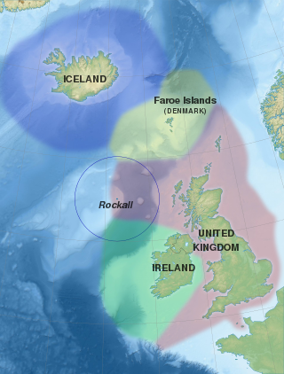
Several states have claimed interests over the sea bed adjoining Rockall, an uninhabitable granite islet which is located within the exclusive economic zone (EEZ) of the United Kingdom. Ireland, Denmark, Iceland, and the United Kingdom have all made submissions to the commission set up under the United Nations Convention on the Law of the Sea (UNCLOS).

The exclusive economic zone of Somalia covers 830,389 km2 in the Indian Ocean. It extends to a distance of 200 nautical miles from the baselines, from which the breadth of the nation's territorial waters is measured. In accordance with Law No. 37 passed in 1972, Somalia's EEZ falls under its territorial sovereignty.

The Blue Amazon or Brazilian maritime territory is the exclusive economic zone (EEZ) of Brazil. It is an offshore area of 3.6 million square km on the Brazilian coast, rich in marine biodiversity and energy resources. The size is equivalent to the surface of the Amazon rainforest. The name is a reference to the biologically rich region of the Brazilian Amazon, with the addition of the adjective blue denoting the ocean.

The marine ecoregions of the South African exclusive economic zone are a set of geographically delineated regions of similar ecological characteristics on a fairly broad scale, covering the exclusive economic zone along the South African coast.

Japan has the eighth-largest exclusive economic zone (EEZ) in the world. The total area of Japan is about 380 thousand km2. Japan's EEZ area is vast and the territorial waters and EEZ together is about 4.47 million km2.

Australia's exclusive economic zone (EEZ) was declared on 1 August 1994 and extends from 12 to 200 nautical miles from the coastline of Australia and its external territories, except where a maritime delimitation agreement exists with another state. To the 12 nautical-mile boundary is Australia's territorial waters. Australia has the third-largest exclusive economic zone, behind France and the United States but ahead of Russia, with the total area of 8,148,250 square kilometres (3,146,060 sq mi), which exceeds its land territory.

The exclusive economic zone of North Korea stretches 200 nautical miles from its basepoints in both the Yellow Sea and the Sea of Japan. The exclusive economic zone (EEZ) was declared in 1977 after North Korea had contested the validity of the Northern Limit Lines (NLL) set up after the Korean War as maritime borders. The EEZ has not been codified in law and North Korea has never specified its coordinates, making it difficult to determine its specific scope.
France has, due to its Overseas departments and regions that are scattered in all the oceans of Earth, the largest exclusive economic zone of the world. The total EEZ of France is 11,691,000 km2 (4,514,000 sq mi).

India has the 18th-largest exclusive economic zone (EEZ) with a total size of 2,305,143 km2 (890,021 sq mi). It includes the Lakshadweep island group in the Laccadive Sea off the southwestern coast of India and the Andaman and Nicobar Islands in the Bay of Bengal and the Andaman Sea. India's EEZ is bordered to the west by Pakistan, to the south by the Maldives and Sri Lanka and to the east by Bangladesh, Myanmar, Thailand, Malaysia and Indonesia. Based on new scientific data, India has petitioned United Nations to extend its EEZ from 200 Nautical miles to 500 miles.
Greece has claimed an Exclusive Economic Zone (EEZ) with a total size of 505,572 km2 (195,202 sq mi), which is the 53rd largest in the world.
The Adjacent Waters Boundaries Order 2002 is a statutory instrument of the United Kingdom government, defining the boundaries of internal waters, territorial sea, and British Fishing Limits adjacent to Northern Ireland. It was introduced in accordance with the Northern Ireland Act 1998, which established the devolved Northern Ireland Assembly.


