Yukon | |
---|---|
Coordinates: 63°N135°W / 63°N 135°W [1] | |
Country | Canada |
Before confederation | District of Yukon |
Confederation | June 13, 1898 (9th) |
Capital (and largest city) | Whitehorse |
Largest metro | Whitehorse |
Government | |
• Type | Parliamentary system |
• Commissioner | Adeline Webber |
• Premier | Ranj Pillai |
Legislature | Yukon Legislative Assembly |
Federal representation | Parliament of Canada |
House seats | 1 of 338 (0.3%) |
Senate seats | 1 of 105 (1%) |
Area | |
• Total | 482,443 km2 (186,272 sq mi) |
• Land | 474,391 km2 (183,163 sq mi) |
• Water | 8,052 km2 (3,109 sq mi) 1.7% |
• Rank | 9th |
4.8% of Canada | |
Population (2021) | |
• Total | 40,232 [3] |
• Estimate (Q4 2024) | 46,948 [4] |
• Rank | 12th |
• Density | 0.08/km2 (0.2/sq mi) |
Demonyms | Yukoner FR: Yukonnais(e) |
Official languages | |
GDP | |
• Rank | 13th |
• Total (2017) | C$3.089 billion [6] |
• Per capita | C$75,141 (3rd) |
HDI | |
• HDI (2021) | 0.930 [7] — Very high (4th) |
Time zone | UTC−07:00 |
Canadian postal abbr. | YT |
Postal code prefix | |
ISO 3166 code | CA-YT |
Flower | Fireweed |
Tree | Subalpine fir [8] |
Bird | Common raven |
Rankings include all provinces and territories |
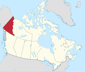
Yukon [a] is the smallest and westernmost of Canada's three territories. It is the most densely populated of the three territories, with an estimated population of 46,948 as of 2024, [4] though it has a smaller population than all provinces. Whitehorse, the territorial capital, is the largest settlement in any of the three territories. [10]
Yukon was split from the Northwest Territories in 1898 as the Yukon Territory. The federal government's Yukon Act, which received royal assent on March 27, 2002, established "Yukon" as the territory's official name, although Yukon Territory remains in popular usage. Canada Post uses the territory's internationally approved postal abbreviation of YT. [11] [9] In 2021, territorial government policy was changed so that "The Yukon" would be recommended for use in official territorial government materials. [12]
Although officially bilingual (English and French), the Yukon government recognizes First Nations languages.
At 5,959 m (19,551 ft), Yukon's Mount Logan, in Kluane National Park and Reserve, is the highest mountain in Canada and the second-highest on the North American continent (after Denali in the U.S. state of Alaska). Most of the Yukon has a subarctic climate, characterized by long, cold winters and brief, warm summers. The coastal area along the Arctic Ocean has a tundra climate.
Notable rivers include the Yukon, Pelly, Stewart, Peel, White, Liard, and Tatshenshini.
The territory is named after the Yukon River, the longest river in the Yukon. The name itself is from a contraction of the words in the Gwich'in phrase chųų gąįį han, which means "white water river" and refers to "the pale colour" of glacial runoff in the Yukon River. [13] [14]
Historically, the name of the Yukon Territory has been abbreviated to "The Yukon" in informal speech. In 2003, the territorial government announced that the territory should be referred to as "Yukon", but the change in name sparked discussion amongst Yukoners. In the 2021 election, the leader of the Yukon NDP, Kate White, campaigned on returning to using "The Yukon". Following the election, the Yukon Liberal Party government announced that "The Yukon" would again be used by the government. [15]
The territory is the approximate shape of a right triangle, bordering the U.S. state of Alaska to the west and northwest for 1,210 kilometres (752 mi) mostly along longitude 141° W, the Northwest Territories to the east and British Columbia to the south mostly along latitude 60° N. [16] Its northern coast is on the Beaufort Sea. Its ragged eastern boundary mostly follows the divide between the Yukon Basin and the Mackenzie River drainage basin to the east in the Mackenzie mountains.
Most of the territory is in the watershed of its namesake, the Yukon River. The southern Yukon is dotted with a large number of large, long and narrow glacier-fed alpine lakes, most of which flow into the Yukon River system. The larger lakes include Teslin Lake, Atlin Lake, Tagish Lake, Marsh Lake, Lake Laberge, Kusawa Lake and Kluane Lake. Bennett Lake on the Klondike Gold Rush trail is a lake flowing into Nares Lake, with the greater part of its area within Yukon. Other watersheds in the territory include the Mackenzie River, the Peel Watershed and the Alsek–Tatshenshini, and a number of rivers flowing directly into the Beaufort Sea. The two main Yukon rivers flowing into the Mackenzie in the Northwest Territories are the Liard River in the southeast and the Peel River and its tributaries in the northeast.
Canada's highest point, Mount Logan (5,959 m or 19,551 ft), is in the territory's southwest. Mount Logan and a large part of the Yukon's southwest are in Kluane National Park and Reserve, a UNESCO World Heritage Site. Other national parks include Ivvavik National Park and Vuntut National Park in the north. A second UNESCO World Heritage Site, Tr'ondëk-Klondike World Heritage Site, was designated in 2023.
Notable widespread tree species within the Yukon are the black spruce and white spruce. Many trees are stunted because of the short growing season and severe climate. [17]
While the average winter temperature in the Yukon is mild by Canadian arctic standards, no other place in North America gets as cold as the Yukon during extreme cold snaps. The temperature has dropped down to −60 °C (−76 °F) three times, 1947, 1952, and 1968. The most extreme cold snap occurred in February 1947 when the abandoned town of Snag dropped down to −63.0 °C (−81.4 °F). [18]
Unlike most of Canada where the most extreme heat waves occur in July, August, and even September, the Yukon's extreme heat tends to occur in June and even May. The Yukon has recorded 36 °C (97 °F) three times. The first time was in June 1969 when Mayo recorded a temperature of 36.1 °C (97 °F). 14 years later this record was almost beaten when Forty Mile recorded 36 °C (97 °F) in May 1983. The old record was finally broken 21 years later in June 2004 when the Mayo Road weather station, located just northwest of Whitehorse, recorded a temperature of 36.5 °C (97.7 °F). [19]
City | July average high | July average low | January average high | January average low |
---|---|---|---|---|
Whitehorse | 21 °C (70 °F) | 8 °C (46 °F) | −11 °C (12 °F) | −19 °C (−2 °F) |
Dawson City | 23 °C (73 °F) | 8 °C (46 °F) | −22 °C (−8 °F) | −30 °C (−22 °F) |
Old Crow | 20 °C (68 °F) | 9 °C (48 °F) | −25 °C (−13 °F) | −34 °C (−29 °F) |
Long before the arrival of Europeans, the central and southern Yukon was populated by First Nations people, and the area escaped glaciation. Sites of archeological significance in the Yukon hold some of the earliest evidence of the presence of human habitation in North America. [21] The sites safeguard the history of the first people and the earliest First Nations of the Yukon. [21]
The volcanic eruption of Mount Churchill in approximately 800 AD in what is now the U.S. state of Alaska blanketed the southern Yukon with a layer of ash which can still be seen along the Klondike Highway, and which forms part of the oral tradition of First Nations peoples in the Yukon and further south in Canada.
Coastal and inland First Nations had extensive trading networks. European incursions into the area began early in the 19th century with the fur trade, followed by missionaries. By the 1870s and 1880s, gold miners began to arrive. This drove a population increase that justified the establishment of a police force, just in time for the start of the Klondike Gold Rush in 1897. The increased population coming with the gold rush led to the separation of the Yukon district from the Northwest Territories and the formation of the separate Yukon Territory in 1898.
The 2021 census reported a Yukon population of 40,232. [22] With a land area of 474,712.64 km2 (183,287.57 sq mi), it had a population density of 0.1/km2 (0.2/sq mi) in 2011, the highest among Canada's three territories. [23] Statistics Canada has estimated Yukon's 2024 population to be 46,948, [24] an increase of 17.5% from the 2016 census. This is the largest percentage increase for any Canadian province or territory.
Unlike in other Canadian provinces and territories, Statistics Canada uses the entire territory as a single at-large census division.
This section's factual accuracy may be compromised due to out-of-date information.(April 2017) |
According to the 2016 Canada Census the majority of the territory's population was of European descent, although it has a significant population of First Nations communities across the territory. The 2011 National Household Survey examined the Yukon's ethnocultural diversity and immigration. At that time, 87.7% of residents were Canadian-born and 24.2% were of Indigenous origin. The most common countries of birth for immigrants were the United Kingdom (15.9%), the Philippines (15.0%), and the United States (13.2%). Among very recent immigrants (between 2006 and 2011) living in the Yukon, 63.5% were born in Asia. [25]
As of the 2016 census, the top ten ancestries in the Yukon were: [28]
Rank | Ethnic group | Population (2016) | Percentage |
---|---|---|---|
1 | English | 9,680 | 27.57% |
2 | Aboriginal | 8,665 | 24.68% |
3 | Canadian | 8,640 | 24.61% |
4 | Scottish | 8,295 | 23.63% |
5 | Irish | 6,930 | 19.74% |
6 | German | 5,575 | 15.88% |
7 | French | 5,040 | 14.35% |
8 | Ukrainian | 2,200 | 6.27% |
9 | Dutch | 1,760 | 5.01% |
10 | Norwegian | 1,380 | 3.93% |
The most commonly reported mother tongue among the 33,145 single responses to the 2011 Canadian census was English at 28,065 (85%). [29] The second-most common was 1,455 (4%) for French. [29] Among 510 multiple respondents, 140 of them (27%) reported a mother tongue of both English and French, while 335 (66%) reported English and a "non-official language" and 20 (4%) reported French and a "non-official language". [29]
The Yukon's Language Act "recognises the significance" of the territory's aboriginal languages in the Yukon, and permits their use in Legislative Assembly proceedings, although only English and French are available for laws and court proceedings. [30]
|
|
The 2021 Canadian census reported that 59.7% of Yukoners reported having no religious affiliation, the highest percentage in Canada. The most frequently reported religious affiliation was Christianity, reported by 35.0% of residents, followed by Sikhism at 1.0%. [32]
Religious beliefs in Yukon (2021 census) [33] | ||
---|---|---|
Religion | Adherents | % of the population |
No religion and secular perspectives | 23,640 | 59.71% |
Christian | 13,860 | 35.01% |
Sikh | 380 | 0.96% |
Traditional (North American Indigenous) spirituality | 325 | 0.82% |
Hindu | 265 | 0.67% |
Buddhist | 260 | 0.66% |
Muslim | 185 | 0.47% |
Jewish | 70 | 0.18% |
Other religions and spiritual traditions | 600 | 1.52% |
Total | 39,590 | 100% |
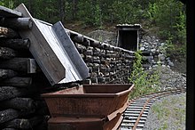
The Yukon's major industry is mining (lead, zinc, silver, gold, asbestos and copper). The federal government acquired the land from the Hudson's Bay Company in 1870 and split it from the Northwest Territories in 1898 to fill the need for local government created by the population influx of the gold rush. Thousands of these prospectors moved to the territory, ushering a period of Yukon history recorded by authors such as Robert W. Service and Jack London. The memory of this period and the early days of the Royal Canadian Mounted Police, as well as the territory's scenic wonders and outdoor recreation opportunities, makes tourism the second most important industry in the territory.
Manufacturing, including furniture, clothing, and handicrafts, follows in importance, along with hydroelectricity. The traditional industries of trapping and fishing have declined. As of 2012, the government sector directly employs approximately 6,300 out of a labour force of 20,800, on a population of 27,500. [34] [35]
On May 1, 2015, the Yukon modified its Business Corporations Act, [36] [37] [38] in an effort to attract more benefits and participants to its economy. One amendment to the BCA lets a proxy be given for voting purposes. Another change will allow directors to pursue business opportunities declined by the corporation, a practice off-limits in most other jurisdictions due to the inherent potential for conflicts of interest. [39] One of the changes will allow a corporation to serve as a director of a subsidiary registered in Yukon. [40] The legislation also allows companies to add provisions in their articles of incorporation giving directors blanket approval to sell off all of the company's assets without requiring a shareholder vote. [40] If provided for by a unanimous shareholders agreement, a corporation is not required to have directors at all. [41] There is increased flexibility regarding the location of corporate records offices, including the ability to maintain a records office outside of the Yukon so long as it is accessible by electronic means. [41]
The Yukon's tourism motto is "Larger than life". [42] The Yukon's tourism industry relies heavily on Yukon's natural environment, and there are many organized outfitters and guides available for activities such as hunting, angling, canoeing/kayaking, hiking, skiing, snowboarding, ice climbing, and dog sledding. These activities are offered both in an organized setting or in the backcountry, which is accessible by air or snowmobile. The Yukon's festivals and sporting events include the Adäka Cultural Festival, Yukon International Storytelling Festival, and the Yukon Sourdough Rendezvous. The Yukon's latitude enables the view of aurora borealis.
The Yukon Government maintains a series of territorial parks, [43] including parks such as Herschel Island Qikiqtaruk Territorial Park, [44] Tombstone Territorial Park, [45] Fishing Branch Ni'iinlii'njik Park, [46] and Coal River Springs Territorial Park. [47] Parks Canada, a federal agency of the Government of Canada, also maintains three national parks and reserves within the territory: Kluane National Park and Reserve, Ivvavik National Park, and Vuntut National Park.
The Yukon is also home to twelve National Historic Sites of Canada. The sites are also administered by Parks Canada, with five of the twelve sites being located within national parks. The territory is host to a number of museums, including the Copperbelt Railway & Mining Museum, the SS Klondike boat museum, the Yukon Beringia Interpretive Centre in Whitehorse; as well as the Keno City Mining Museum in Keno City. The territory also holds a number of enterprises that allows tourists to experience pre-colonial and modern cultures of Yukon's First Nations and Inuit. [48]
The Yukon has a wide array of cultural and sporting events that attract artists, local residents, and tourists. Annual events include the Adäka Cultural Festival, Dawson City Music Festival, Yukon International Storytelling Festival, Yukon Quest dog sled race, Yukon Sourdough Rendezvous, as well as Klondike Gold Rush memorials [49] [50] and the Northern Lights Centre. [51] [52]
The Yukon's Aboriginal culture is also strongly reflected in such areas as winter sports, as in the Yukon Quest sled dog race. The modern comic-book character Yukon Jack depicts a heroic aboriginal persona. Similarly, the territorial government also recognizes that First Nations and Inuit languages plays a part in cultural heritage of the territory; these languages include Tlingit, and the less common Tahltan, as well as seven Athapaskan languages, Upper Tanana, Gwich'in, Hän, Northern Tutchone, Southern Tutchone, Kaska, and Tagish, some of which are rare. [53]
Notable Yukon artists include Jim Robb and Ted Harrison, whose paintings have become iconic for their depictions of historic and contemporary life and culture in the Yukon. [54]
With the Klondike Gold Rush, a number of folk songs from the Yukon became popular, including "Rush to the Klondike" (1897, written by W. T. Diefenbaker), "The Klondike Gold Rush", "I've Got the Klondike Fever" (1898), and "La Chanson du Klondyke".
A notable cultural and tourist feature is the legacy of the Klondike Gold Rush (1897–1899), which inspired contemporary writers of the time such as Jack London, Robert W. Service, and Jules Verne, and which continues to inspire films and games, such as Mae West's Klondike Annie and The Yukon Trail .
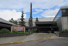
Executive power in the Yukon is formally vested in the Territorial Commissioner, [55] who plays an analogous role to that of a provincial lieutenant governor. As guarantor of responsible government in the territory, the Commissioner generally acts on the advice of the Premier of Yukon, who commands the confidence of the elected Legislative Assembly. Unlike lieutenant governors, commissioners are not direct representatives of the King but are instead appointed by the federal government.
The Yukon has numerous political parties and candidates who stand for election to the 19 seats in the Yukon Legislative Assembly. Those elected to the legislature are known as members of the Legislative Assembly and may use the post nominal letters "MLA". The three parties presently represented are the centre-leaning Yukon Liberal Party (8 seats) – who currently form government, the centre-right leaning Yukon Party (8), and the centre-left leaning Yukon New Democratic Party (3). [56]
The 10th and current premier of Yukon is Ranj Pillai, who represents the electoral district of Porter Creek South as its MLA. Pillai took office on January 14, 2023. After the 2021 Yukon general election, the Liberals were reduced to a minority government, though they were able to continue governing due to a formal agreement with the NDP. [57]
The vast majority of the Yukon's land mass is unorganized, with no defined municipal or otherwise supralocal level of government like in other parts of Canada.
For most individuals in the Yukon, though, local level governance is provided by municipalities. The Yukon's eight municipalities cover only 0.2% of the territory's land mass [b] but are home to 80.9% of its population. [59] [60] [61]
Municipal governments are created by the Yukon Government in accordance with the Municipal Act of 2001. [62] Municipal governments provide "jurisdiction services, facilities, or things that a local government considers necessary or desirable for all or part of its community". [62] Classifications of municipalities under the Municipal Act include cities and towns. [62] Whitehorse is the capital of the Yukon and its only city. The remaining seven municipalities are towns, of which four were villages that were continued as towns upon adoption of the 2001 Municipal Act. [62]
The usage is somewhat confusing: according to the Municipal Act of 2001 villages are legally given the status of towns, but may call themselves villages in English. In French they are called villages, and the French word ville, which means town, is not used for them. Instead larger settlements are called ville and even bigger ones grande ville, apart from Dawson which is called a cité, and in English is also called a city. Keno City, though unincorporated, also bears city in its name.
In the 19th century, the Yukon was a segment of North-Western Territory that was administered by the Hudson's Bay Company, and then of the Northwest Territories administered by the federal Canadian government. It only obtained a recognizable local government in 1895 when it became a separate district of the Northwest Territories. [63] In 1898, it was made a separate territory with its own commissioner and an appointed Territorial Council. [64]
Prior to 1979, the territory was administered by the commissioner who was appointed by the federal Minister of Indian Affairs and Northern Development. The commissioner had a role in appointing the territory's Executive Council, served as chair, and had a day-to-day role in governing the territory. The elected Territorial Council had a purely advisory role. In 1979, a significant degree of power was devolved from the commissioner and the federal government to the territorial legislature which, in that year, adopted a party system of responsible government. This change was accomplished through a letter from Jake Epp, Minister of Indian Affairs and Northern Development, rather than through formal legislation.
In preparation for responsible government, political parties were organized and ran candidates to the Yukon Legislative Assembly for the first time in 1978. The Progressive Conservatives won these elections and formed the first party government of the Yukon in January 1979. The Yukon New Democratic Party (NDP) formed the government from 1985 to 1992 under Tony Penikett and again from 1996 under Piers McDonald until being defeated in 2000. The conservatives returned to power in 1992 under John Ostashek after having renamed themselves the Yukon Party. The Liberal government of Pat Duncan was defeated in elections in November 2002, with Dennis Fentie of the Yukon Party forming the government as premier. In 2003, the old Yukon Act was repealed and replaced by a new Yukon Act, which continued the existing powers of the Yukon Government, and devolved additional powers to the territorial government such as control over land and natural resources. [65]
At the federal level, the Yukon is represented in the Parliament of Canada by one member of Parliament (MP) and one senator. MPs from Canadian territories are full and equal voting representatives and residents of the territory enjoy the same rights as other Canadian citizens. One Yukon MP, Erik Nielsen, served as Deputy Prime Minister under Brian Mulroney, while another, Audrey McLaughlin, was the leader of the federal New Democratic Party (NDP) from 1989 to 1995.
A substantial minority of the territory's population is First Nations. An umbrella land claim agreement representing 7,432 members of fourteen different First Nations was signed with the federal government in 1993. Eleven of the fourteen Yukon First Nations have negotiated and signed comprehensive land claim and self-government agreements. The fourteen First Nations speak eight different languages. The territory once had an Inuit settlement, located on Herschel Island off the Arctic Ocean coast. This settlement was dismantled in 1987 and its inhabitants relocated to the neighbouring Northwest Territories. As a result of the Inuvialuit Final Agreement, the island is now a territorial park and is known officially as Qikiqtaruk Territorial Park, Qikiqtaruk being the name of the island in Inuvialuktun. |
|
Before modern forms of transportation, the rivers and mountain passes were the main transportation routes for the coastal Tlingit people trading with the Athabascans of the Chilkoot Pass and Dalton Trail, as well as the first Europeans.
Erik Nielsen Whitehorse International Airport serves as the air transport infrastructure hub, with scheduled direct flights to Calgary, Dawson City, Edmonton, Inuvik, Kelowna, Ottawa, Toronto–Pearson, Vancouver, Victoria, Watson Lake, and Yellowknife. It was formerly connected to Frankfurt by Condor before the airline temporarily suspended the route in 2023 until completion of runway reconstruction project when services are expected to resume. [80]
Yukon passenger rail | ||||||||||||||||||||||||||||||||||||||||||
---|---|---|---|---|---|---|---|---|---|---|---|---|---|---|---|---|---|---|---|---|---|---|---|---|---|---|---|---|---|---|---|---|---|---|---|---|---|---|---|---|---|---|
| ||||||||||||||||||||||||||||||||||||||||||
The railway ceased operation in the 1980s with the first closure of the Faro mine. It is now run during the summer months for the tourism season, with operations between Carcross and Skagway, Alaska. [81]
The Alaska-Alberta Railway Development Corporation (A2A) is planning to construct a new railway line that would cross the Yukon, connecting Watson Lake and possibly Carmacks but not Whitehorse.
Today, major land routes include the Alaska Highway, the Klondike Highway (between Skagway and Dawson City), the Haines Highway (between Haines, Alaska, and Haines Junction), and the Dempster Highway (linking Inuvik, Northwest Territories to the Klondike Highway, and the only road access route to the Arctic Ocean in Canada), all paved except for the Dempster. Other highways with less traffic include the Robert Campbell Highway linking Carmacks (on the Klondike Highway) to Watson Lake (Alaska Highway) via Faro and Ross River, and the Silver Trail linking the old silver mining communities of Mayo, Elsa, and Keno City to the Klondike Highway at the Stewart River bridge. Air travel is the only way to reach the far-north community of Old Crow.
From the Gold Rush until the 1950s, riverboats plied the Yukon River, mostly between Whitehorse and Dawson City, with some making their way further to Alaska and over to the Bering Sea, and other tributaries of the Yukon River such as the Stewart River. Most of the riverboats were owned by the British-Yukon Navigation Company, an arm of the White Pass and Yukon Route, which also operated a narrow-gauge railway between Skagway, Alaska, and Whitehorse.
The Northwest Territories is a federal territory of Canada. At a land area of approximately 1,127,711.92 km2 (435,412.01 sq mi) and a 2021 census population of 41,070, it is the second-largest and the most populous of the three territories in Northern Canada. Its estimated population as of the second quarter of 2024 is 44,936. Yellowknife is the capital, most populous community, and the only city in the territory; its population was 20,340 as of the 2021 census. It became the territorial capital in 1967, following recommendations by the Carrothers Commission.
Whitehorse is the capital of the Yukon, and the largest city in Northern Canada. It was incorporated in 1950 and is located at kilometre 1426 on the Alaska Highway in southern Yukon. Whitehorse's downtown and Riverdale areas occupy both shores of the Yukon River, which rises in British Columbia and meets the Bering Sea in Alaska. The city was named after the White Horse Rapids for their resemblance to the mane of a white horse, near Miles Canyon, before the river was dammed.
The Yukon River is a major watercourse of northwestern North America. From its source in British Columbia, it flows through Canada's territory of Yukon. The lower half of the river continues westward through the U.S. state of Alaska. The river is 3,190 kilometres (1,980 mi) long and empties into the Bering Sea at the Yukon–Kuskokwim Delta. The average flow is 6,400–7,000 m3/s (230,000–250,000 cu ft/s). The total drainage area is 854,700 km2 (330,000 sq mi), of which 323,800 km2 (125,000 sq mi) lies in Canada. The total area is more than 25% larger than Texas or Alberta.
Northern Canada, colloquially the North or the Territories, is the vast northernmost region of Canada, variously defined by geography and politics. Politically, the term refers to the three territories of Canada: Yukon, Northwest Territories and Nunavut. This area covers about 48 per cent of Canada's total land area, but has less than 0.5 per cent of Canada's population.
Tutchone is an Athabaskan language spoken by the Northern and Southern Tutchone First Nations in central and southern regions of Yukon Territory, Canada. Tutchone belongs to the Northern Athabaskan linguistic subfamily and has two primary varieties, Southern and Northern. Although they are sometimes considered separate languages, Northern and Southern Tutchone speakers are generally able to understand each other in conversation, albeit with moderate difficulty.
Dawson City, officially the City of Dawson, is a town in the Canadian territory of Yukon. It is inseparably linked to the Klondike Gold Rush (1896–1899). Its population was 1,577 as of the 2021 census, making it the second-largest municipality in Yukon.
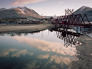
Carcross, originally known as Caribou Crossing, is an unincorporated community in Yukon, Canada, on Bennett Lake and Nares Lake. It is home to the Carcross/Tagish First Nation.
Carmacks is a village in Yukon, Canada, on the Yukon River along the Klondike Highway, and at the west end of the Robert Campbell Highway from Watson Lake. The population is 588, an increase from the Census of 2016. It is the home of the Little Salmon/Carmacks First Nation, a Northern Tutchone-speaking people.
Watson Lake is a town in Yukon, Canada, located at mile 635 on the Alaska Highway close to the British Columbia border. It had a population of 1,133 in 2021. The town is named for Frank Watson, an American-born trapper and prospector, who settled in the area at the end of the 19th century.
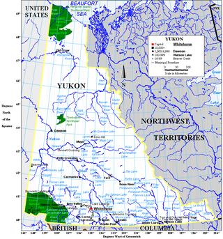
Yukon is in the northwestern corner of Canada and is bordered by Alaska, British Columbia and the Northwest Territories. The sparsely populated territory abounds with natural scenery, snowmelt lakes and perennial white-capped mountains, including many of Canada's highest mountains. The territory's climate is Arctic in territory north of Old Crow, subarctic in the region, between Whitehorse and Old Crow, and humid continental climate south of Whitehorse and in areas close to the British Columbia border. Most of the territory is boreal forest with tundra being the main vegetation zone only in the extreme north and at high elevations.
The White River First Nation (WRFN) is a First Nation of Upper Tanana, Northern Tutchone, and Southern Tutchone peoples in the western Yukon Territory in Canada. Its main population centre is Beaver Creek, Yukon.
Ross River is an unincorporated community in Yukon, Canada. It lies at the junction of the Ross River and the Pelly River, along the Canol Road, not far from the Campbell Highway. Primary access to the Campbell Highway is via a nine-mile access road. Formerly it was accessed along a six-mile Canol Road section that is no longer maintained. It is serviced by Ross River Airport, used mainly for charter and scheduled flights to and from Whitehorse and Watson Lake.
Pelly Crossing is a community in Yukon, Canada. It lies where the Klondike Highway crosses the Pelly River.
Marsh Lake is an unincorporated community on the Alaska Highway on the shores of Marsh Lake southeast of Whitehorse in Canada's Yukon. The area was organized in 2001, as a local area council to help the residents with some form of municipal government.
Kluane is an electoral district which returns a member to the Legislative Assembly of the Canadian territory of Yukon. It is named after Kluane National Park, which is within the riding. It is one of the Yukon's eight rural districts.
The history of the Yukon covers the period from the arrival of Paleo-Indians through the Beringia land bridge approximately 20,000 years ago. In the 18th century, Russian explorers began to trade with the First Nations people along the Alaskan coast, and later established trade networks extending into Yukon. By the 19th century, traders from the Hudson's Bay Company were also active in the region. The region was administered as a part of the North-Western Territory until 1870, when the United Kingdom transferred the territory to Canada and it became the North-West Territories.
Frederick Howard Collins October 1, 1897 – August 24, 1988) was the commissioner of Yukon from 1955 to 1962. He succeeded Wilfred George Brown and was followed in the position by George Robertson Cameron. The Yukon territorial government today resembles those in the Canadian provinces, i.e., parliamentary with a Legislative Assembly and a Premier as head of government. But historically, and during the term of Collins, the federally-appointed Commissioner was the empowered chief executive of the territory.
The Indigenous peoples of Yukon are ethnic groups who, prior to European contact, occupied the former countries now collectively known as Yukon. While most First Nations in the Canadian territory are a part of the wider Dene Nation, there are Tlingit and Métis nations that blend into the wider spectrum of indigeneity across Canada. Traditionally hunter-gatherers, indigenous peoples and their associated nations retain close connections to the land, the rivers and the seasons of their respective countries or homelands. Their histories are recorded and passed down the generations through oral traditions. European contact and invasion brought many changes to the native cultures of Yukon including land loss and non-traditional governance and education. However, indigenous people in Yukon continue to foster their connections with the land in seasonal wage labour such as fishing and trapping. Today, indigenous groups aim to maintain and develop indigenous languages, traditional or culturally-appropriate forms of education, cultures, spiritualities and indigenous rights.
{{cite web}}
: CS1 maint: multiple names: authors list (link)Length of boundary by province – Yukon- 1,210 km or 752 miles