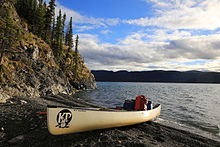
The Klondike is a region of the territory of Yukon, in northwestern Canada. It lies around the Klondike River, a small river that enters the Yukon River from the east at Dawson City. The area is merely an informal geographic region, and has no function to the territory as any kind of administrative region.

Yukon is the smallest and westernmost of Canada's three territories. It is the most densely populated of the three territories, with an estimated population of 46,704 as of 2024, though it has a smaller population than all provinces. Whitehorse, the territorial capital, is the largest settlement in any of the three territories.

The Yukon River is a major watercourse of northwestern North America. From its source in British Columbia, it flows through Canada's territory of Yukon. The lower half of the river continues westward through the U.S. state of Alaska. The river is 3,190 kilometres (1,980 mi) long and empties into the Bering Sea at the Yukon–Kuskokwim Delta. The average flow is 6,400–7,000 m3/s (230,000–250,000 cu ft/s). The total drainage area is 854,700 km2 (330,000 sq mi), of which 323,800 km2 (125,000 sq mi) lies in Canada. The total area is more than 25% larger than Texas or Alberta.

Dawson City, officially the City of Dawson, is a town in the Canadian territory of Yukon. It is inseparably linked to the Klondike Gold Rush (1896–1899). Its population was 1,577 as of the 2021 census, making it the second-largest municipality in Yukon.
"The Cremation of Sam McGee" is among the most famous of Robert W. Service's poems. It was published in 1907 in Songs of a Sourdough. It concerns the cremation of a prospector who freezes to death near Lake Laberge, Yukon, Canada, as told by the man who cremates him.

Bennett Lake is a lake in the Province of British Columbia and Yukon Territory in northwestern Canada, at an elevation of 656 m (2,152 ft). It is just north of the border with the United States state of Alaska, near the Alaskan port of Skagway. The lake has an estimated area of about 90.68 or 96.8 km2. The average depth is 61.9 m (203 ft) and the maximum depth is 123 m (404 ft).
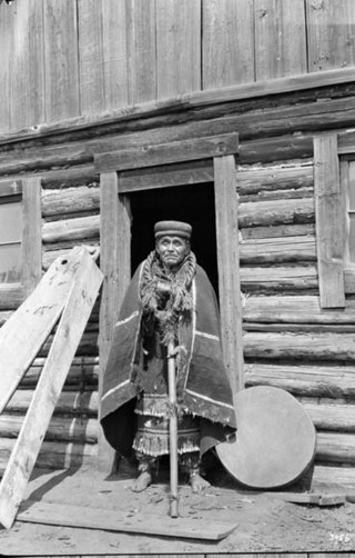
The Tagish or Tagish Khwáan are a First Nations people of the Athabaskan-speaking ethnolinguistic group that lived around Tagish Lake and Marsh Lake, in Yukon of Canada. The Tagish intermarried heavily with Tlingit from the coast and the Tagish language became extinct in 2008. Today Tagish people live mainly in Carcross or Whitehorse and are members of the Carcross/Tagish First Nation or the Kwanlin Dün First Nation.
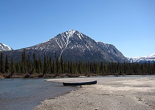
Tagish Lake is a lake in Yukon and northern British Columbia, Canada. The lake is 119 kilometres (74 mi) long and averages 3.2 km (2 mi) wide with an area of 354.48 km2 (136.87 sq mi), about two thirds of which is in British Columbia. The average depth is 62 m (203 ft) and maximum depth is 307 m (1,007 ft).

Klondike Gold Rush National Historical Park is a national historical park operated by the National Park Service that seeks to commemorate the Klondike Gold Rush of the late 1890s. Though the gold fields that were the ultimate goal of the stampeders lay in the Yukon Territory, the park comprises staging areas for the trek there and the routes leading in its direction. There are four units, including three in Municipality of Skagway Borough, Alaska and a fourth in the Pioneer Square National Historic District in Seattle, Washington.

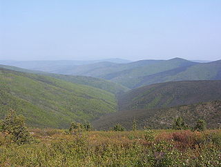
Yukon is in the northwestern corner of Canada and is bordered by Alaska, British Columbia and the Northwest Territories. The sparsely populated territory abounds with natural scenery, snowmelt lakes and perennial white-capped mountains, including many of Canada's highest mountains. The territory's climate is Arctic in territory north of Old Crow, subarctic in the region, between Whitehorse and Old Crow, and humid continental climate south of Whitehorse and in areas close to the British Columbia border. Most of the territory is boreal forest with tundra being the main vegetation zone only in the extreme north and at high elevations.
Marsh Lake is a widening of the Yukon River southeast of Whitehorse, Yukon, Canada. It is over 30 kilometres (19 mi) long and ranges from three to four kilometres wide. It has an area of 96.3 km2 (37.2 sq mi) and a mean depth of 12.8 m (42 ft). The co-ordinates of the lake are 60°26′10″N134°15′02″W, and is 654 metres (2,147 ft) above sea level. The lake forms part of a chain of finger lakes, sometimes referred to as "The Southern Lakes", that form the headwaters of the Yukon River.

Lake Laberge is an electoral district which returns a member to the Legislative Assembly of the Yukon Territory in Canada. It is one of the Yukon's eight rural districts and is named after the eponymous Lake Laberge, which is within the riding.
The Takhini River is a watercourse in Yukon, Canada. The river is located just north of Whitehorse, Yukon, and flows from west to east, meeting the Yukon River at a point between Whitehorse and Lake Laberge. During the winter, the river freezes and serves as part of the route of the Yukon Quest sled dog race.
The Snafu Lakes are a chain of lakes in southern Yukon, Canada, about 25 to 30 km north of the border with British Columbia. It is drained by Snafu Creek. The two lakes principally of interest to anglers are Upper Snafu and Lower Snafu, which are separated by about 1.5 kilometres (0.9 mi) of the Snafu Creek. The lakes have the following dimensions:
Tarfu Lake is a lake of Yukon, Canada. The lake is both fed and drained by Tarfu Creek. The name is from WWII-era Military slang, an acronym for Things Are Really Fouled Up. The lake is approximately 4.5 kilometres (2.8 mi) long, 1.21 km (0.75 mi) wide, has a surface area of 404 hectares, a mean depth of 11.6 metres (38 ft) and a maximum depth of 33 metres (108 ft).
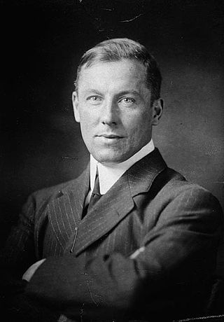
Robert William Service was a Scottish-Canadian poet and writer, often called “The Poet of the Yukon" and "The Canadian Kipling". Born in Lancashire of Scottish descent, he was a bank clerk by trade, but spent long periods travelling in the west in the United States and Canada, often in poverty. When his bank sent him to the Yukon, he was inspired by tales of the Klondike Gold Rush, and wrote two poems, "The Shooting of Dan McGrew" and "The Cremation of Sam McGee", which showed remarkable authenticity from an author with no experience of the gold rush or mining, and enjoyed immediate popularity. Encouraged by this, he quickly wrote more poems on the same theme, which were published as Songs of a Sourdough, and achieved a massive sale. When his next collection, Ballads of a Cheechako, proved equally successful, Service could afford to travel widely and live a leisurely life, basing himself in Paris and the French Riviera.
Songs of a Sourdough is a book of poetry published in 1907 by Robert W. Service. In the United States, the book was published under the title The Spell of the Yukon and Other Verses.
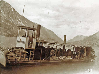
A. J. Goddard was a Klondike Gold Rush era sternwheeler owned by Seattle businessman Albert J. Goddard and built for transport of men and supplies on the Upper Yukon River in Canada. She was assembled from pieces which were manufactured in San Francisco, shipped up to Skagway, Alaska, hauled over the Coast Mountains, and finally assembled at Lake Bennett. She made one trip to Dawson during the gold rush, was sold and sank in a storm on Lake Laberge in 1901. Her wreck was discovered in 2008 by Doug Davidge and was designated as a Yukon Historic Site.

Jim Boss was an entrepreneur and the chief of the Southern Tutchone Ta’an Kwäch’än for over 40 years. He is most known for having initiated the first Yukon land claim, in 1902. His leadership allowed the First Nations from the southern region of the Yukon to make the transition from a traditional way of life to a Euro-Canadian economy. In 2001, he was designated a Person of National Historic Significance.