Yukon River

Last updated
Yukon River
Canoeing the Yukon River.jpg
Canoeing the Yukon River
Yukon watershed.png
Location of the Yukon River and watershed
Native name
Location
Countries
State Alaska
Province/Territory
Physical characteristics
Source Llewellyn Glacier at Atlin Lake
  location Atlin District, British Columbia, Canada
  coordinates 59°10′N133°50′W / 59.167°N 133.833°W / 59.167; -133.833
  elevation669 m (2,195 ft) [1]
Mouth Bering Sea
  location
Kusilvak, Alaska, U.S.
  coordinates
62°35′55″N164°48′00″W / 62.59861°N 164.80000°W / 62.59861; -164.80000
  elevation
0 m (0 ft)
Length3,190 km (1,980 mi)
Basin size833,232 km2 (321,713 sq mi) to 854,700 km2 (330,000 sq mi) [2]
Width 
  average0.8 km (0.50 mi) Rampart to Tanana; [3] 820 m (2,690 ft) to 1,000 m (3,300 ft) (Pilot Station) [4]
Depth 
  average9.1 m (30 ft)-12.1 m (40 ft) (Rampart to Tanana); [3]
  maximum40 m (130 ft) (Rampart); [3] 24.4 m (80 ft) (Pilot Station) [4]
Discharge 
  location Pilot Station, Alaska, U.S.— (121 miles upstream of mouth; Basin size: 820,856 km2 (316,934 sq mi); [5] 831,386 km2 (321,000 sq mi) [2] [6]
  average(Period of data: 2000/10/01–2023/09/30) 6,860.3 m3/s (242,270 cu ft/s) [7]

(Period of data: 1971–2015) 6,576 m3/s (232,200 cu ft/s) [5]

(Period of data: 1977–2006) 6,428

Contents

 m3/s (227,000 cu ft/s) [8]
  minimum340 m3/s (12,000 cu ft/s)
  maximum24,600 m3/s (870,000 cu ft/s) 34,000 m3/s (1,200,000 cu ft/s) (2005) [7]
Discharge 
  location Yukon Delta, U.S., Alaska, Bering Sea
  average
  • (Period of data: 1984–2018) 212 km3/a (6,700 m3/s)
  • (Period of data: 1951–2017) 214 km3/a (6,800 m3/s) [8]
  • (Period: 1980–2017) 206 km3/a (6,500 m3/s) [8] (Period: 1951–1979) 225 km3/a (7,100 m3/s) [8]
Discharge 
  location Kaltag (450 miles upstream of mouth; Basin size: 767,000 km2 (296,000 sq mi) [2]
  average6,040.2 m3/s (213,310 cu ft/s) [6] to 6,130.6 m3/s (216,500 cu ft/s) [2]
Discharge 
  location Stevens Village (Basin size: 508,417 km2 (196,301 sq mi) [6]
  average(Period of data: 1977–2022) 3,471.1 m3/s (122,580 cu ft/s) [2]
Discharge 
  location Dawson (1,300 miles upstream of mouth; Basin size: 264,000 km2 (102,000 sq mi) [6]
  average2,160 m3/s (76,000 cu ft/s) [6] to 2,319.1 m3/s (81,900 cu ft/s) [9]
Basin features
Tributaries 
  left White, Fortymile, Birch Creek, Tanana, Nowitna, Innoko
  rightTagish River, Atlin, Teslin, Big Salmon, Pelly, Stewart, Klondike, Porcupine, Christian, Chandalar, Melozitna, Koyukuk, Anvik, Atchuelinguk, Andreafsky
[10] [11]

The Yukon River is a major watercourse of northwestern North America. From its source in British Columbia, it flows through Canada's territory of Yukon (itself named after the river). The lower half of the river continues westward through the U.S. state of Alaska. The river is 3,190 kilometres (1,980 mi) [11] [12] long and empties into the Bering Sea at the Yukon–Kuskokwim Delta. The average flow is 6,400–7,000 m3/s (230,000–250,000 cu ft/s). [2] The total drainage area is 833,000 km2 (321,500 sq mi), [2] of which 323,800 km2 (125,000 sq mi) lies in Canada. [13] The total area is more than 25% larger than Texas or Alberta.

The longest river in Alaska and Yukon, it was one of the principal means of transportation during the 1896–1903 Klondike Gold Rush. A portion of the river in Yukon—"The Thirty Mile" section, from Lake Laberge to the Teslin River—is a national heritage river and a unit of Klondike Gold Rush International Historical Park. [14] [15] Paddle-wheel riverboats continued to ply the river until the 1950s, when the Klondike Highway was completed. After the purchase of Alaska by the United States in 1867, the Alaska Commercial Company acquired the assets of the Russian-American Company and constructed several posts at various locations on the Yukon River.

The Yukon River has a recent history of pollution from military installations, dumps, wastewater, and other sources. [16] [ failed verification ][ citation needed ] However, the Environmental Protection Agency does not list the Yukon River among its impaired watersheds, and water-quality data from the U.S. Geological Survey shows relatively good levels of turbidity, metals, and dissolved oxygen. [17] The Yukon and Mackenzie rivers have much higher suspended sediment concentrations than the great Siberian Arctic rivers. [18]

The Yukon River Inter-Tribal Watershed Council, a cooperative effort of 70 First Nations and tribes in Alaska and Canada, has the goal of making the river and its tributaries safe to drink from again by supplementing and scrutinizing government data.

Name

The name Yukon, or ųųg han, is a contraction of the words in the Gwich'in phrase chųų gąįį han, which means white water river and refers to "the pale colour" of glacial runoff in the Yukon River. [19] [20] The contraction is Ųųg Han, if the /ųų/ remains nasalized, or Yuk Han, if there is no vowel nasalization. [21] In the 1840s, different tribes had different opinions as to the literal meaning of Yukon. In 1843, the Holikachuks had told the Russian-American Company that their name for the river was Yukkhana and that this name meant big river. [22] However, Yukkhana does not literally correspond to a Holikachuk phrase that means big river. [23] [24] Then, two years later, the Gwich'ins told the Hudson's Bay Company that their name for the river was Yukon and that the name meant white water river. [19] White water river in fact corresponds to Gwich'in words that can be shortened to form Yukon. [20] Because the Holikachuks had been trading regularly with both the Gwich’ins and the Yup'iks, [25] the Holikachuks were in a position to borrow the Gwich'in contraction and to conflate its meaning with the meaning of Kuig-pak [River-big], which is the Yup'ik name for the same river. For that reason, the documentary evidence suggests that the Holikachuks had borrowed the contraction Ųųg Han [White Water River] from Gwich'in, and erroneously assumed that this contraction had the same literal meaning as the corresponding Yup'ik name Kuig-pak [River-big].

The Lewes River is the former name of the upper course of the Yukon, from Marsh Lake to the confluence of the Pelly River at Fort Selkirk.
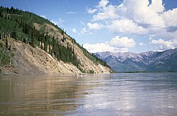
Course

Map of the Yukon River watershed Yukon River drainage basin.gif
Map of the Yukon River watershed

The generally accepted source of the Yukon River is the Llewellyn Glacier at the southern end of Atlin Lake in British Columbia. Others suggest that the source is Lake Lindeman at the northern end of the Chilkoot Trail. Either way, Atlin Lake flows into Tagish Lake (via the Atlin River), as eventually does Lake Lindeman after flowing into Bennett Lake. Tagish Lake then flows into Marsh Lake (via the Tagish River). The Yukon River proper starts at the northern end of Marsh Lake, just south of Whitehorse. Some argue that the source of the Yukon River should really be Teslin Lake and the Teslin River, which has a larger flow when it reaches the Yukon at Hootalinqua. The upper end of the Yukon River was originally known as the Lewes River until it was established that it actually was the Yukon. North of Whitehorse, the Yukon River widens into Lake Laberge, made famous by Robert W. Service's "The Cremation of Sam McGee". Other large lakes that are part of the Yukon River system include Kusawa Lake (into the Takhini River) and Kluane Lake (into the Kluane and then White River).

The river passes through the communities of Whitehorse, Carmacks, (just before the Five Finger Rapids) and Dawson City in Yukon, and crossing Alaska into Eagle, Circle, Fort Yukon, Stevens Village, Rampart, Tanana, Ruby, Galena, Nulato, Grayling, Holy Cross, Russian Mission, Marshall, Pilot Station, St. Marys (which is accessible from the Yukon at Pitkas Point), and Mountain Village. After Mountain Village, the main Yukon channel frays into many channels, sprawling across the delta. There are a number of communities after the "head of passes," as the channel division is called locally: Nunum Iqua, Alakanuk, Emmonak, and Kotlik. Of those delta communities, Emmonak is the largest with roughly 760 people in the 2000 census. Emmonak's gravel airstrip is the regional hub for flights.

Hazards

The bridge across the Yukon River at Carmacks on the Klondike Highway Carmacs-bridge across Yukon River.JPG
The bridge across the Yukon River at Carmacks on the Klondike Highway
The E. L. Patton Yukon River Bridge carries the Dalton Highway over the Yukon north of Fairbanks. Patton Yukon River Bridge.jpg
The E. L. Patton Yukon River Bridge carries the Dalton Highway over the Yukon north of Fairbanks.

Navigational obstacles on the Yukon River are the Five Finger Rapids and Rink Rapids downstream from Carmacks.

Bridges

Despite its length, there are only four vehicle-carrying bridges across the river, listed from upstream to downstream:

A car ferry crosses the river at Dawson City in the summer; it is replaced by an ice bridge over the frozen river during the winter. Plans to build a permanent bridge were announced in March 2004, although they are currently on hold because bids came in much higher than budgeted.

There are also two pedestrian-only bridges in Whitehorse, as well as a dam across the river and a hydroelectric generating station. The construction of the dam flooded the White Horse Rapids, which gave the city its name, and created Schwatka Lake.

Transportation is also performed along the river in summer by barge, enabling heavy goods, oil, and vehicles to be transported to communities along the Yukon, Tanana, Innoko, and Koyukuk rivers. This service is performed by Ruby Marine and reaches Tanana on the Yukon River and Nenana on the Tanana River. [26]

Geography and ecology

Some of the upper slopes of this watershed (e.g. Nulato Hills) are forested by Black Spruce. [27] This locale near the Seward Peninsula represents the near westernmost limit of the Black Spruce, Picea mariana, [28] one of the most widespread conifers in northern North America.

The river flows into several parklands and refuges including:

Crossing the Lake Laberge by canoe 2015-08-20 Canoeing the Yukon River - Whitehorse to Carmarcks 1442.jpg
Crossing the Lake Laberge by canoe

Discharge

Yukon at Pilot Station (121 miles upstream of mouth) minimum, average and maximum discharge: [7] [29] [30]

Water yearDischarge (Period: 1975/10/01 – 2023/09/30)
MinMeanMax
cfsm3/scfs m3/s km3cfsm3/s
1975/76 65,0001,840218,300 6,182 195 700,00019,800
1976/77 44,0001,250204,100 5,779 182 669,00018,900
1977/78 42,0001,190185,300 5,247 166 465,00013,200
1978/79 40,0001,130224,200 6,349 200 587,00016,600
1979/80 50,0001,420236,900 6,708 212 660,00018,700
1980/81 40,0001,130229,600 6,502 205 563,00015,900
1981/82 38,0001,080240,800 6,819 215 866,00024,500
1982/83 45,0001,270218,900 6,199 196 554,00015,700
1983/84 35,000990231,900 6,567 207 642,00018,200
1984/85 40,0001,130239,200 6,773 214 1,100,00031,150
1985/86 50,0001,420231,400 6,553 207 585,00016,600
1986/87 47,0001,330223,800 6,337 200 649,00018,400
1987/88 50,0001,420218,700 6,193 195 680,00019,300
1988/89 55,0001,560225,500 6,385 202 800,00022,650
1989/90 47,0001,330235,400 6,666 210 900,00025,500
1990/91 50,0001,420249,800 7,074 223 1,070,00030,300
1991/92 46,0001,300239,500 6,782 214 788,00022,300
1992/93 50,0001,420240,400 6,807 215 854,00024,200
1993/94 50,0001,420253,700 7,184 227 660,00018,700
1994/95 42,0001,190218,300 6,182 195 696,00019,700
1995/96 36,0001,020209,700 5,938 187 502,00014,200
1996/97 No incomplete data have been used

for statistical calculation

1997/98
1998/99
1999/00
1975–199645,8001,300227,4006,439203713,80020,200
2000/01 46,0001,300249,500 7,067 223 901,00025,500
2001/02 38,0001,080210,400 5,958 188 884,00025,000
2002/03 48,0001,360236,500 6,697 211 543,00015,400
2003/04 46,5001,320211,800 5,998 189 648,00018,350
2004/05 41,0001,160254,600 7,209 228 1,240,00035,100
2005/06 45,0001,270252,300 7,144 226 920,00026,050
2006/07 38,0001,080213,600 6,048 191 531,00015,000
2007/08 40,5001,150231,600 6,558 207 775,00021,950
2008/09 48,0001,360231,900 6,567 207 1,090,00030,900
2009/10 42,0001,190205,600 5,822 184 675,00019,100
2010/11 47,0001,330227,000 6,428 203 670,00019,000
2011/12 44,0001,250247,700 7,014 221 660,00018,700
2012/13 48,5001,370231,700 6,561 207 820,00023,200
2013/14 45,0001,270266,400 7,544 238 553,00015,700
2014/15 55,0001,560229,400 6,499 205 621,00017,600
2015/16 58,0001,640274,600 7,776 245 603,00017,100
2016/17 46,7001,320214,900 6,085 192 562,00015,900
2017/18 48,0001,360257,600 7,294 230 669,00018,900
2018/19 60,9001,730233,300 6,606 208 647,00018,300
2019/20 52,4001,480290,900 8,237 260 704,00019,900
2020/21 50,9001,440262,200 7,425 234 589,00016,700
2021/22 49,4001,400269,900 7,643 241 682,00019,300
2022/2364,9001,840268,8007,6112401,140,00032,300
2000–202348,0001,360242,3006,860216744,65021,100
1975–202347,0001,330234,7006,646210729,90020,650

Fisheries

The Yukon River is home to one of the longest salmon runs in the world. Each year Chinook, coho, and chum salmon return to their terminal streams in Alaska, the Yukon Territory, and British Columbia. As salmon do not eat during their spawning migration, Yukon River salmon must have great reserves of fat and energy to fuel their thousands-mile-long journey. The Chinook, which arrive at the mouth of the Yukon River in early June, have the longest journey – as many as 2,000 miles against the current, with an estimated 35–50% bound for Canada. As a result, Chinook salmon are noted for their especially rich and fatty meat and are the priciest of all Pacific salmon species. [31]

The villages along the Yukon have historically relied on and continue to rely on salmon for their cultural, subsistence, and commercial needs. Salmon are traditionally dried, smoked, and frozen for both human and sled dog consumption. Common methods of fishing on the Yukon include set gillnets, drift nets, dip nets, and fish wheels. The preference of certain gear is largely dependent on the river's varied characteristics in different areas. Some parts of the river do not have eddies to make set-nets successful, whereas in other places the tributaries are small enough to make drifting impractical.

Over the last 20 years salmon recruitment, the number of returning adults, has taken several shocks. The late 1980s, 1990s, and 2000s have been marked by radically reduced runs for various salmon species. In the summer of 2023, the U.S. Fish and Wildlife Service counted 58,500 Chinook salmon, the second lowest season on record. [32] The United States Department of Commerce issued a Federal Disaster Declaration for the 2008 and 2009 Commercial Chinook Yukon River fisheries, calling for the complete closure of commercial fishing along with restrictions on subsistence fishing.[ citation needed ] The root cause of these poor returns remains debated, with questions about the effects of climate change on ocean food-supply & disease prevalence in returning adults, the methods of fishing used on the river, and the effects of the Bering Sea Pollock trawl fleet on food supply and salmon bycatch. [33] [34] In 2010, the Alaska Department of Fish & Game's Board of Fisheries issued the first-ever restriction for net mesh size on the Yukon, reducing it to 7.5 inches (190 mm). [35] In 2021, the Alaska Department of Fish & Game's Division of Commercial Fisheries banned all fishing of Chinook and chum salmon, including for subsistence. [31] [36]

Various organizations are involved to protect healthy salmon runs into the future. The Yukon River Drainage Fisheries Association was formed in 1990 by a consensus of fishers representing the entire drainage in response to recent disaster years. Its organizational goals include giving voice to the village fishers that have traditionally managed these resources, enabling communication between fishers and fishery managers, and helping to preserve the ecological integrity of salmon runs and local cultures' Traditional Ecological Knowledge [37]

In March 2001, the U.S. & Canadian governments passed the Yukon River Salmon Agreement to better manage an internationally shared resource and ensure that more Canadian-originated salmon return across the border. [38] The agreement is implemented through the Yukon River Panel, an international body of 12 members, equal-parts American and Canadian, that advises managers of Yukon River fisheries concerning restoration, conservation, and coordinated management. [39]

Tribal organizations such as the Association of Village Council Presidents (AVCP), Council of Athabascan Tribal Governments (CATG), and Tanana Chiefs Conference (TCC) work to sustain Yukon River salmon to promote healthy people, cultures, and communities.

Tributaries

Yukon River near Carmacks Rio Yukon, Carmacks, Yukon, Canada, 2017-08-27, DD 01-04 PAN.jpg
Yukon River near Carmacks

Yukon Territory

The Yukon River, as seen from the Midnight Dome in Dawson City, Yukon The Yukon River.jpg
The Yukon River, as seen from the Midnight Dome in Dawson City, Yukon

Alaska

Anabranches near the junction of the Yukon River and the Koyukuk River in Alaska, August 24, 1941 Junction of the Yukon and Koyukuk Rivers, Alaska.jpg
Anabranches near the junction of the Yukon River and the Koyukuk River in Alaska, August 24, 1941

List of major tributaries

The main river and tributaries are (sorted in order from the mouth heading upstream):

Left

tributary

Right

tributary

Length

(km)

Basin size

(km2)

Average discharge

(m3/s)

Yukon Delta
Nanvaranak Slough 1,735 28.1
Archuelinguk 56 705 12.8
Lower Yukon
Andreafsky 193 5,369 91.4
Kashunuk

(distributary)

362 2,906 51.7
Atchuelinguk 266 5,439 73.8
Reindeer 97 1,191 22
Talbiksok 129 1,857 26.5
Kako Creek 550 9.8
Innoko 805 36,517 335.5
Koserefski 48 897 13.1
Bonasila 201 3,108 43.7
Anvik 225 4,610 65
Khotol 137 2,331 40.1
Nulato 114 2,287 54.2
Koyukuk 805 81,326 770
Bear Creek 789 10.8
Kala Creek 893 13
Yuki 137 2,771 33.4
Melozitna 217 7,045 67.6
Big Creek 814 4.6
Nowitna 455 18,596 102.4
Blind 34 587 3.4
Boney Creek 72 788 3.9
Tozitna 134 4,248 28.2
Tanana 1,061 113,959 1,246
Middle Yukon
Hess Creek 80 3,082 15.6
Ray 69 1,751 14.2
Dall 129 3,714 17.6
Old Lost Creek 10.3
Hodzana 201 4,323 19.5
Beaver Creek 290 5,426 54.9
Hadweenzic 150 2,422 19.4
Birch Creek 241 13,064 127
Chandalar 328 24,165 141.8
Christian 225 8,827 67.8
Porcupine 916 116,431 623
Charley 142 4,377 22.7
Kandik 132 2,840 19.7
Nation 113 2,411 24.6
Tatonduk 110 15.6
Upper Yukon
Seventymile 93 7.5
Fortymile 97 16,602 79.4
Klondike 161 8,044 63.9
Indian 2,242 20.4
Sixtymile 137 3,719 25.4
Stewart 533 51,023 510
White 322 46,900 566
Pelly 608 48,174 412
Nordenskiöld 6,371 16
Little Salmon 3,626 9.7
Big Salmon 240 6,760 67.6

Teslin

393 35,014 331
Takhini 180 6,993 103.1
Atlin 6,812 110

[2] [9] [40]

In media

See also

Related Research Articles

<span class="mw-page-title-main">Interior Alaska</span> Geographic region

Interior Alaska is the central region of Alaska's territory, roughly bounded by the Alaska Range to the south and the Brooks Range to the north. It is largely wilderness. Mountains include Denali in the Alaska Range, the Wrangell Mountains, and the Ray Mountains. The native people of the interior are Alaskan Athabaskans. The largest city in the interior is Fairbanks, Alaska's second-largest city, in the Tanana Valley. Other towns include North Pole, just southeast of Fairbanks, Eagle, Tok, Glennallen, Delta Junction, Nenana, Anderson, Healy and Cantwell. The interior region has an estimated population of 113,154.

<span class="mw-page-title-main">Yukon</span> Territory of Canada

Yukon is the smallest and westernmost of Canada's three territories. It is the third-least populated province or territory in Canada, with a population of 45,148 as of 2023. However, Whitehorse, the territorial capital, is the largest settlement in any of the three territories.

<span class="mw-page-title-main">Yukon–Koyukuk Census Area, Alaska</span> Census area in Alaska, United States

Yukon–Koyukuk Census Area is a census area in the U.S. state of Alaska. As of the 2020 census, the population was 5,343, down from 5,588 in 2010. With an area of 147,842.51 sq mi (382,910.3 km2), it is the largest of any county or county-equivalent in the United States, or slightly larger than the entire state of Montana. It is part of the unorganized borough of Alaska and therefore has no borough seat. Its largest communities are the cities of Galena, in the west, and Fort Yukon, in the northeast.

<span class="mw-page-title-main">Koyukuk River</span> River in Alaska, United States

The Koyukuk River is a 425-mile (684 km) tributary of the Yukon River, in the U.S. state of Alaska. It is the last major tributary entering the Yukon before the larger river empties into the Bering Sea.

<span class="mw-page-title-main">Chena River</span> River in Alaska, United States

The Chena River is a 100-mile (160 km) tributary of the Tanana River in the Interior region of the U.S. state of Alaska. It flows generally west from the White Mountains to the Tanana River near the city of Fairbanks, which is built on both sides of the river. The Tanana empties into the 2,300-mile (3,700 km) long Yukon River.

<span class="mw-page-title-main">Gwichʼin</span> Ethnic group

The Gwichʼin are an Athabaskan-speaking First Nations people of Canada and an Alaska Native people. They live in the northwestern part of North America, mostly north of the Arctic Circle.

<span class="mw-page-title-main">Chandalar River</span> River in the United States of America

The Chandalar River is a 100-mile (160 km) tributary of the Yukon River in the U.S. state of Alaska. Its peak flow, recorded by the United States Geological Survey (USGS) between 1964 and 1974 at a stream gauge at Venetie, was 62,800 cubic feet per second (1,780 m3/s) on June 9, 1968.

<span class="mw-page-title-main">Geography of Yukon</span>

Yukon is in the northwestern corner of Canada and is bordered by Alaska and the Northwest Territories. The sparsely populated territory abounds with natural scenery, snowmelt lakes and perennial white-capped mountains, including many of Canada's highest mountains. The territory's climate is Arctic in territory north of Old Crow, subarctic in the region, between Whitehorse and Old Crow, and humid continental climate south of Whitehorse and in areas close to the British Columbia border. Most of the territory is boreal forest with tundra being the main vegetation zone only in the extreme north and at high elevations.

<span class="mw-page-title-main">Northern Athabaskan languages</span> Languages spoken in northwest North America

Northern Athabaskan is a geographic sub-grouping of the Athabaskan language family spoken by indigenous peoples in the northern part of North America, particularly in Alaska, Yukon, and the Northwest Territories. The Northern Athabaskan languages consist of 31 languages that can be divided into seven geographic subgroups.

<span class="mw-page-title-main">Hän</span> Indigenous people of Yukon and Alaska

The Hän, Han or Hwëch'in / Han Hwech’in are a First Nations people of Canada and an Alaska Native Athabaskan people of the United States; they are part of the Athabaskan-speaking ethnolinguistic group. Their traditional lands centered on a heavily forested area around the Upper Yukon River, Klondike River (Tr'on'Dëk), Bonanza Creek and Sixtymile River and straddling what is now the Alaska-Yukon Territory border. In later times, the Han population became centered in Dawson City, Yukon and Eagle, Alaska.

<span class="mw-page-title-main">David Salmon (tribal chief)</span>

Chief David Salmon was an indigenous Alaskan that served as Chief of Chalkyitsik and later First Traditional Chief for the Gwich'in people. He was known for his commitment to improving his community and working for the people. Salmon would use his position and influence as chief to begin many public works and create programs dedicated to helping the Gwich'in people. As an advocate for education, Salmon would spread his knowledge by creating traditional Athabascan items for display or teaching his community to keep Athabascan traditions alive. At the same time, Chief Salmon would be trained and become the first Episcopal priest for Interior Alaska and spend a lot of his life spreading his faith.

<span class="mw-page-title-main">Interior Alaska–Yukon lowland taiga</span> Taiga ecoregion of Canada and the United States

The interior Alaska–Yukon lowland taiga is an ecoregion in the taiga and boreal forests biome, of far northern North America.

<span class="mw-page-title-main">Alaskan Athabaskans</span> Athabaskan-speaking Alaska Native group

The Alaskan Athabascans, Alaskan Athapascans or Dena are Alaska Native peoples of the Athabaskan-speaking ethnolinguistic group. They are the original inhabitants of the interior of Alaska.

<span class="mw-page-title-main">Tanana Athabaskans</span> Alaskan Athabaskan peoples

The Tanana Athabaskans, Tanana Athabascans or Tanana Athapaskans are an Alaskan Athabaskan peoples of the Athabaskan-speaking ethnolinguistic group. They are the original inhabitants of the Tanana River drainage basin in east-central Alaska Interior, United States and a little part lived in Yukon, Canada. Tanana River Athabaskan peoples are called in Lower Tanana and Koyukon language Ten Hʉt'ænæ, in Gwich'in language Tanan Gwich'in. In Alaska, where they are the oldest, there are three or four groups identified by the languages they speak. These are the Tanana proper or Lower Tanana and/or Middle Tanana, Tanacross or Tanana Crossing, and Upper Tanana. The Tanana Athabaskan culture is a hunter-gatherer culture and have a matrilineal system. Tanana Athabaskans were semi-nomadic and as living in semi-permanent settlements in the Tanana Valley lowlands. Traditional Athabaskan land use includes fall hunting of moose, caribou, Dall sheep, and small terrestrial animals, and also trapping. The Athabaskans did not have any formal tribal organization. Tanana Athabaskans were strictly territorial and used hunting and gathering practices in their semi-nomadic way of life and dispersed habitation patterns. Each small band of 20–40 people normally had a central winter camp with several seasonal hunting and fishing camps, and they moved cyclically, depending on the season and availability of resources.

<span class="mw-page-title-main">Upper Kuskokwim people</span>

The Upper Kuskokwim people or Upper Kuskokwim Athabaskans, Upper Kuskokwim Athabascans, and historically Kolchan, Goltsan, Tundra Kolosh, and McGrath Ingalik are an Alaskan Athabaskan people of the Athabaskan-speaking ethnolinguistic group. First delineation of this ethnolinguistic group was described by anthropologist Edward Howard Hosley in 1968, as Kolchan. According to Hosley, "Nevertheless, as a group possessing a history and a culture differing from those of its neighbours, the Kolchan deserve to be recognized as an independent group of Alaskan Athapaskans." They are the original inhabitants of the Upper Kuskokwim River villages of Nikolai, Telida, and McGrath, Alaska. About 25 of a total of 100 Upper Kuskokwim people still speak the language. They speak a distinct Athabaskan language more closely related to Lower Tanana language than to Deg Xinag language, spoken on the middle Kuskokwim. The term used by the Kolchan themselves is Dina'ena, but this is too similar to the adjacent Tanana and Tanaina for introduction into the literature. Nowadays, the term used by the Kolchan themselves is Dichinanek' Hwt'ana. Their neighbors also knew them by this name. In Tanaina they were Kenaniq' ht'an while the Koyukon people to the north referred to them as Dikinanek Hut'ana. The Upper Kuskokwim Athabaskan culture is a hunter-gatherer culture and have a matrilineal system. They were semi-nomadic and lived in semi-permanent settlements.

<span class="mw-page-title-main">Yukon River Basin</span> River

The Yukon River Basin is located between the Yukon Territory in Canada and Alaska in the United States, with a small portion in British Columbia, Canada. This basin is made up of 13 other individual basins that drain into the Yukon River and other adjoining rivers and tributaries. The Yukon River Basin is 330,000 square miles (850,000 km2) in area and 1,980 miles (3,190 km) in length. Many different geological features make up the basin, including several types of terrain, shrubland, and rivers.

References

  1. "Atlin Lake". Peakbagger.com. Retrieved 11 October 2020.
  2. 1 2 3 4 5 6 7 8 "USGS".
  3. 1 2 3 "Yukon River Panel".
  4. 1 2 "Yukon (Pilot) River".
  5. 1 2 Stadnyk, Tricia A.; Tefs, A.; Broesky, M.; Déry, S. J.; Myers, P. G.; Ridenour, N. A.; Koenig, K.; Vonderbank, L.; Gustafsson, D. (2021). "Changing freshwater contributions to the Arctic". Elementa: Science of the Anthropocene. 9. doi: 10.1525/elementa.2020.00098 . S2CID   236682638.
  6. 1 2 3 4 5 "GRDC".
  7. 1 2 3 "USGS 15565447 YUKON R AT PILOT STATION AK".
  8. 1 2 3 4 "River Discharge". Arctic.noaa.gov. Archived from the original on 13 August 2022. Retrieved 11 June 2022.
  9. 1 2 "Rivers Network".
  10. Brabets, Timothy P; Wang, Bronwen; Meade, Robert H. (2000). "Environmental and Hydrologic Overview of the Yukon River Basin, Alaska and Canada" (PDF). United States Geological Survey . Retrieved 5 March 2010.
  11. 1 2 Yukon River at the Encyclopædia Britannica
  12. "Yukoninfo.com". Yukoninfo.com. Archived from the original on 2013-10-24. Retrieved 2013-08-18.
  13. Walvoord, Michelle A.; Striegl, Robert G. (2007-06-28). "Increased groundwater to stream discharge from permafrost thawing in the Yukon River basin: Potential impacts on lateral export of carbon and nitrogen". Geophysical Research Letters. 34 (12): L12402. doi: 10.1029/2007GL030216 . ISSN   0094-8276. S2CID   128894194.
  14. The Thirty Mile (Yukon River) National Heritage River Archived January 6, 2011, at the Wayback Machine , National Heritage Rivers System
  15. Klondike Gold Rush International Historical Park Archived October 9, 2012, at the Wayback Machine , Parks Canada
  16. "Earth Snapshot • Yukon River". Eosnap.com. Archived from the original on 2020-10-27. Retrieved 2018-02-09.
  17. "USGS Water Quality Samples – 1 sites found". Nwis.waterdata.usgs.gov. Retrieved 2013-08-18.
  18. "Arctic Great Rivers Observatory". Arctic Great Rivers. Retrieved 2018-04-10.
  19. 1 2 "Dear Sir, I have great pleasure in informing you that I have at length after much trouble and difficulties, succeed[ed] in reaching the 'Youcon', or white water River, so named by the (Gwich'in) natives from the pale colour of its water. ..., I have the honour to Remain Your obt Servt, John Bell" Hudson's Bay Company Correspondence to George Simpson from John Bell (August 1, 1845), HBC Archives, D.5/14, fos. 212-215d, also quoted in, Coates, Kenneth S. & William R. Morrison (1988). Land of the Midnight Sun: A History of the Yukon. Hurtig Publishers. p. 21. ISBN   0-88830-331-9 . Retrieved 2017-10-16.
  20. 1 2 In Gwich'in, adjectives, such as choo [big] and gąįį [white], follow the nouns that they modify. Thus, white water is chųų gąįį [water white]. White water river is chųų gąįį han [water white river]. Peter, Katherine (1979). Dinjii Zhuh Ginjik Nagwan Tr'iłtsąįį: Gwich'in Junior Dictionary (PDF). Univ. of Alaska. pp. ii (ą, į, ų are nasalized a, i, u), xii (adjectives follow nouns), 19 (nitsii or choo [big]), 88 (ocean = chųų choo [water big]), 105 (han [river]), 142 (chųų [water]), 144 (gąįį [white]). Retrieved 2017-10-16.
  21. Gwich'in vowels may or may not be nasalized. A hook under a vowel, as in "ų," indicates that the vowel is nasalized. Peter (1979). Dinjii Zhuh Ginjik Nagwan Tr'iłtsąįį., at page ii (footnote). English, of course, has no nasalized vowels.
  22. "[The Yukon] in the language of the Kang-ulit (Yup'ik) people is Kvikhpak; in the dialect of the downriver Inkilik (Holikachuk), Yukkhana; of those upriver (Koyukon), Yuna. All these terms mean the same thing in translation–'Big River.' I have kept the local names as a clearer indication of the different tribes along the river." Lt. Zagoskin's Note 63 (1848), translated in, Zagoskin, Lavrenty A.; Henry N. Michael, eds. (1967). Lieutenant Zagoskin's Travels in Russian America, 1842-1844: The First Ethnographic and Geographic Investigations in the Yukon and Kuskokwim Valleys of Alaska. University of Toronto Press., at page 295. Zagoskin did not come into contact with the Gwich'in Indians and had no access to the information that Yukon means white water river in Gwich'in – the language from which the word came.
  23. In Holikachuk, big river or big water would be xinmiksekh, xinchux, toomiksekh, or toochux. Kari, James; et al. (1978). Holikachuk Noun Dictionary (PDF). Univ. of Alaska Fairbanks. p. 19 (xin [river], too [water]). Retrieved 2017-10-16.; Zagoskin; Michael (1967). Lieutenant Zagoskin's Travels., at page 309 (Inkilik proper [Holikachuk] tu [water], miksekh [large]); Hargus, Sharon (2008). Vowel quality and duration in Deg Xinag (PDF). Univ. of Washington. p. 29 (note 33: Holikachuk chux [big]). Retrieved 2017-10-16. Adjectives followed the nouns that they modified in Holikachuk.
  24. Thirty-nine pages of cited "Sources," representing over a century of research, did not verify Zagoskin's report that Yukon means big river. Orth (1967). Dictionary of Alaska Place Names., at pp. 6-44 ("Sources of Names"), 1069 ("The Eskimo ... descriptively called it 'Kuikpak' meaning 'big river.' The Indian name 'Yukon' probably means the same thing."). Orth does not say "probably" when discussing Kuikpak's meaning. Orth's use of "probably" is limited to the discussion of Yukon's meaning, which indicates that Zagoskin's report that Yukon means big river was never verified. In addition, Orth's "Sources" do not even include the Hudson's Bay Company correspondence, which states that Yukon means white water river in Gwich'in. Nor do Orth's "Sources" include aboriginal dictionaries.
  25. Lt. Zagoskin reported that: "The ... Inkilit [Holikachuk] ... live along the routes of communication between the Yukon and the coast and are occupied almost exclusively with buying up furs from the natives living along the Yunnaka (Koyukuk River, a Yukon tributary)." Zagoskin also reported that: "The Inkalik [Holikachuk] ..., who are chiefly occupied in trading both with their fellow tribesmen and with the neighboring tribes of Kang-ulit (Yup'ik), have adopted the way of life of the latter ..." Zagoskin; Michael (1967). Lieutenant Zagoskin's Travels., at pp. 196-97, 244. Because they had adopted the Yup’ik (Eskimo) way of life, and because they were the ones trading upriver, the Holikachuk would have been "the Esquimaux" referred to in John Bell's 1845 report: "The Esquimaux to the westwards likewise ascends the 'Youcon' and carry on a trade with the natives, as well as with the Musquash [Gwich'in] Indians ... I have seen a large camp of the latter tribe on the Rat River on my return, who, had about a doz: of beat [hammered] Iron Kettles of Russian Manufacture which they bartered from the Esquimaux." See, Hudson's Bay Company Correspondence to Simpson from Bell (1845), HBC Archives, D.5/14, fos. 212, 213. For these reasons, the Holikachuk were in a position to conflate the meanings of the Gwich'in and Yup'ik names, and to furnish this conflated information to the Russian-American Company.
  26. "Ruby Marine". Rubymarineinc.com. Retrieved 11 June 2022.
  27. Scott R. Robinson. 1988. Movement and Distribution of Western Arctic Caribou Herd across the Buckland Valley and Nulato Hills, U.S. Bureau of Land Management Open file Report 23, Alaska
  28. C. Michael Hogan, Black Spruce: Picea mariana, GlobalTwitcher.com, ed. Nicklas Stromberg, November, 2008 Archived October 5, 2011, at the Wayback Machine
  29. "USGS Surface Water for USA: USGS Surface-Water Daily Statistics for the Nation".
  30. "USGS Current Conditions for USGS 15565447 YUKON R AT PILOT STATION AK".
  31. 1 2 Graham, Max (November 9, 2023). "Salmon are vanishing from the Yukon River — and so is a way of life". Grist. Retrieved November 24, 2023.
  32. https://www.doi.gov/sites/doi.gov/files/tab2-yukon-river-salmon-summary-fall-2023508.pdf
  33. Thiessen, Mark. Feds declare fisheries disaster for Yukon River Archived December 6, 2010, at the Wayback Machine . Fairbanks Daily News-Miner. Retrieved 15 March 2010
  34. Hopkins, Kyle. Pollock vs. salmon bycatch issue stirs waters at meeting Archived June 10, 2011, at the Wayback Machine . Anchorage Daily News. Retrieved 15 March 2010
  35. Associated Press. Fisheries board restricts Yukon salmon gillnets Archived March 9, 2010, at the Wayback Machine . Anchorage Daily News. Retrieved 15 March 2010
  36. http://www.adfg.alaska.gov/static/applications/dcfnewsrelease/1323432313.pdf
  37. Sea Grant Alaska. Yukon Fishermen Celebrate Ten Years. Arctic Science Journeys. Retrieved 15 March 2010
  38. Yukon River Salmon Agreement. Yukonriverpanel.com, March 2001
  39. Bylaws of the Yukon River Panel Society. Yukonriverpanel.com, November 2002
  40. "Alaska Guide Co".
  41. Alcinii, Daniele (June 26, 2015). "Nat Geo sets summer premieres for adventure series". Real Screen. Retrieved August 31, 2015.