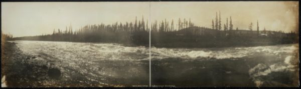
Whitehorse is the capital of Yukon, and the largest city in Northern Canada. It was incorporated in 1950 and is located at kilometre 1426 on the Alaska Highway in southern Yukon. Whitehorse's downtown and Riverdale areas occupy both shores of the Yukon River, which rises in British Columbia and meets the Bering Sea in Alaska. The city was named after the White Horse Rapids for their resemblance to the mane of a white horse, near Miles Canyon, before the river was dammed.

Yukon is the smallest and westernmost of Canada's three territories. It also is the second-least populated province or territory in Canada, with a population of 44,238 as of March 2023. Whitehorse, the territorial capital, is the largest settlement in any of the three territories.

The Yukon River is a major watercourse of northwestern North America. From its source in British Columbia, Canada, it flows through Canada's territory of Yukon. The lower half of the river continues westward through the U.S. state of Alaska. The river is 3,190 kilometres (1,980 mi) long and empties into the Bering Sea at the Yukon–Kuskokwim Delta. The average flow is 6,400–7,000 m3/s (230,000–250,000 cu ft/s). The total drainage area is 833,000 km2 (321,500 sq mi), of which 323,800 km2 (125,000 sq mi) lies in Canada. The total area is more than 25% larger than Texas or Alberta.

The White Pass and Yukon Route is a Canadian and U.S. Class III 3 ft narrow-gauge railroad linking the port of Skagway, Alaska, with Whitehorse, the capital of Yukon. An isolated system, it has no direct connection to any other railroad. Equipment, freight and passengers are ferried by ship through the Port of Skagway, and via road through a few of the stops along its route.

Bennett Lake is a lake in the Province of British Columbia and Yukon Territory in northwestern Canada, at an elevation of 2602 ft.. It is just north of the border with the United States state of Alaska, near the Alaskan port of Skagway.

The 2002 Yukon general election was held on November 4, 2002 to elect members of the 31st Yukon Legislative Assembly in Yukon, Canada.

Schwatka Lake is a reservoir created by the damming of the Yukon River in Whitehorse, Yukon, completed in 1958. The dam provides electrical power generation and is operated by the Yukon Energy Corporation. The White Horse Rapids, which gave the city its name, are now under the lake. The lake was named after Frederick Schwatka, a US Army Lieutenant who was first to explore the total length of the Yukon River.

The Canol Road was part of the Canol Project and was built to construct a pipeline from Norman Wells, Northwest Territories, to Whitehorse, Yukon, during World War II. The pipeline no longer exists, but the 449 kilometres (279 mi) long Yukon portion of the road is maintained by the Yukon Government during summer months. The portion of the road that still exists in the NWT is called the Canol Heritage Trail. Both road and trail are incorporated into the Trans-Canada Trail.

Yukon is in the northwestern corner of Canada and is bordered by Alaska and the Northwest Territories. The sparsely populated territory abounds with natural scenic beauty, with snowmelt lakes and perennial white-capped mountains, including many of Canada's highest mountains. The territory's climate is Arctic in territory north of Old Crow, subarctic in the region, between Whitehorse and Old Crow, and humid continental climate south of Whitehorse and in areas close to the British Columbia border. Most of the territory is boreal forest with tundra being the main vegetation zone only in the extreme north and at high elevations.
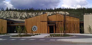
The Kwanlin Dün First Nation (KDFN) or Kwänlin Dän kwächʼǟn is located in and around Whitehorse in Yukon, Canada.

The Southern Tutchone are a First Nations people of the Athabaskan-speaking ethnolinguistic group living mainly in the southern Yukon in Canada. The Southern Tutchone language, traditionally spoken by the Southern Tutchone people, is a variety of the Tutchone language, part of the Athabaskan language family. Some linguists suggest that Northern and Southern Tutchone are distinct and separate languages.
Yukon Energy Corporation is a Crown corporation which is the primary producer of electricity in the Canadian territory of Yukon. It also distributes electricity to a small number of locations not served by the privately-owned ATCO Electric Yukon. YEC was established in 1987 to take over the Yukon assets of the Northern Canada Power Commission and is currently organised as a subsidiary of the Yukon Development Corporation. The company's headquarters is in Whitehorse, Yukon near the Whitehorse Rapids hydroelectric generating station.
Marsh Lake is a widening of the Yukon River southeast of Whitehorse, Yukon, Canada. It is over 30 kilometres long and ranges from three to four kilometres wide. The co-ordinates of the lake are 60°26′10″N134°15′02″W, and is 2,147 feet above sea level. The lake forms part of a chain of finger lakes, sometimes referred to as "The Southern Lakes", that form the headwaters of the Yukon River.
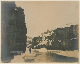
Canyon City is a Klondike Gold Rush ghost town and a Yukon Government Heritage Site. It is located about 7 km from downtown Whitehorse, Yukon at the upstream end of Miles Canyon on the Yukon River. Summer tours are encouraged.
Ibex Mountain is a young cinder cone in the Yukon Territory, Canada, located 33 km southwest of Whitehorse and 12 km southeast of Mount Arkell. It is in a group of basaltic cones and lava flows called Alligator Lake and is in the Northern Cordilleran Volcanic Province. It is believed Ibex Mountain last erupted during the Pleistocene. Ibex Mountain is at the head of the Ibex River, which is southeast of Whitehorse. There is a road that runs close to Ibex Lake on the southeast side of the summit. From there is the hike to the summit of the cone.
The Miles Canyon Basalts represent a package of rocks that include various exposures of basaltic lava flows and cones that erupted and flowed across an ancient pre-glacial landscape in south-central Yukon.
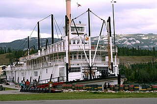
SS Klondike is the name of two sternwheelers, the second now a National Historic Site located in Whitehorse, Yukon. They ran freight between Whitehorse and Dawson City, along the Yukon River, the first from 1929 to 1936 and the second, an almost exact replica of the first, from 1937 to 1950.
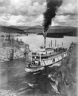
Steamboats on the Yukon River played a role in the development of Alaska and Yukon. Access to the interior of Alaska and Yukon was hindered by large mountains and distance, but the wide Yukon River provided a feasible route. The first steamers on the lower Yukon River were work boats for the Collins Overland Telegraph in 1866 or 1867, with a small steamer called Wilder. The mouth of the Yukon River is far to the west at St. Michael and a journey from Seattle or San Francisco covered some 4,000 miles (6,400 km).
The Takhini River is a watercourse in Yukon, Canada. The river is located just north of Whitehorse, Yukon, and flows from west to east, meeting the Yukon River at a point between Whitehorse and Lake Laberge. During the winter, the river freezes and serves as part of the route of the Yukon Quest sled dog race.

The SS Keno is a preserved historic sternwheel paddle steamer, a National Historic Site of Canada, and a unit of the Canadian national park system. The SS Keno is berthed in a dry dock on the waterfront of the Yukon River in Dawson City, Yukon, Canada.