Margaree River

Last updated
Margaree River
Margaree river sm.jpg
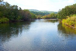
The Margaree River at Gillisdale
Location
Country Canada
Province Nova Scotia
Physical characteristics
Mouth  
  location
Gulf of Saint Lawrence
  coordinates
46°25′38.3″N61°5′50.4″W / 46.427306°N 61.097333°W / 46.427306; -61.097333 (Margaree River) Coordinates: 46°25′38.3″N61°5′50.4″W / 46.427306°N 61.097333°W / 46.427306; -61.097333 (Margaree River)
  elevation
sea level
Length120 km (75 mi)
Basin size1,375 km2 (531 sq mi) [1]

The Margaree River (Abhainn Mhargaraidh) is a river on Cape Breton Island in Nova Scotia. The northeast branch of the river derives from the watershed of the Cape Breton Highlands, while the Southwest Margaree flows northeast from Lake Ainslie. The two branches join at Margaree Forks. The river then flows north to empty into the Gulf of Saint Lawrence at Margaree Harbour, Nova Scotia. The river is 120 km in length and drains an area of 1,375 km². The Margaree has been well known for a century for its trout and Atlantic salmon sport fishery, that draws anglers from near and far. Fishing is highly regulated now and is restricted to fly fishing only, with barbless hooks, in the main stem of the river. Famed American angler and Atlantic salmon conservationist Lee Wulff caught his first salmon on a fly on the Margaree in 1933. [2]

Contents

The gravel bars of the upper Northeast Margaree provide spawning grounds for Atlantic salmon; its steep valleys provide habitat for American marten and the rare Gaspé shrew. The Margaree Valley includes a mix of farms and woodlands.

During the 18th century, Acadians settled along the coast near the mouth of the river; the French name for this river was St. Marguerite. Scottish Highlanders began to settle in the Margaree Valley at the beginning of the 19th century.

Moses Coady, a noted son of the Margaree Valley, attended school in Margaree Forks and later, taught there before completing his education in Antigonish and Rome. [3]

The Margaree was designated a Canadian Heritage River in 1998.

HMCS Margaree, a World War II Canadian naval destroyer, was named after this river.

See also

Related Research Articles

Cape Breton Island Island in Nova Scotia

Cape Breton Island is an island on the Atlantic coast of North America and part of the province of Nova Scotia, Canada.

The Maritimes Region in Canada

The Maritimes, also called the Maritime provinces, is a region of Eastern Canada consisting of three provinces: New Brunswick, Nova Scotia, and Prince Edward Island (PEI). The Maritimes had a population of 1,813,606 in 2016, which makes up 5.6% of Canada's population. Together with Canada's easternmost province, Newfoundland and Labrador, the Maritime provinces make up the region of Atlantic Canada.

Gulf of St. Lawrence The outlet of the North American Great Lakes via the St. Lawrence River into the Atlantic Ocean

The Gulf of St. Lawrence is the outlet of the North American Great Lakes via the St. Lawrence River into the Atlantic Ocean. The gulf is a semi-enclosed sea, covering an area of about 226,000 square kilometres (87,000 sq mi) and containing about 34,500 cubic kilometres (8,300 cu mi) of water, which results in an average depth of 152 metres (499 ft).

Cabot Trail

The Cabot Trail is a highway and scenic roadway in northern Victoria County and Inverness County on Cape Breton Island in Nova Scotia, Canada.

Jimmy Tompkins (priest)

Reverend James John Tompkins was a Roman Catholic priest who founded the Antigonish Movement, a progressive effort that incorporated adult education, cooperatives and rural community development to aid the fishing and mining communities of northern and eastern Nova Scotia, Canada. The Antigonish Movement later evolved into the Extension Department of St. Francis Xavier University.

Allan J. MacEachen Port Hawkesbury Airport Airport in Nova Scotia, Canada

Allan J. MacEachen Port Hawkesbury Airport is a registered aerodrome located 2.1 nautical miles north of Port Hawkesbury, Nova Scotia, Canada.

Cosseboom is a type of artificial fly, commonly used in fly fishing to catch salmon. It was created by the American angler John C. Cosseboom of Woonsocket, Rhode Island in around 1923, for use on the Margaree River in Nova Scotia, Canada.

Mira River (Nova Scotia)

The Mira River is a Canadian river located in eastern Cape Breton Island, Nova Scotia.

The Eastern Shore is a region of the Canadian province of Nova Scotia. It is the Atlantic coast running northeast from Halifax Harbour to the eastern end of the peninsula at the Strait of Canso.

Trunk 19 is part of the Canadian province of Nova Scotia's system of trunk highways. The road runs from Port Hastings to a junction with the Cabot Trail at Margaree Forks on Cape Breton Island, a distance of 107 kilometres (66 mi). Most of the route is known as the Ceilidh Trail.

Sheet Harbour, Nova Scotia Rural Community in Nova Scotia, Canada

Sheet Harbour is a rural community on the Eastern Shore of Nova Scotia, Canada. It is located in the eastern reaches of the Halifax Regional Municipality, approximately 117 km (73 mi) northeast of the central urban area of the municipality, concentrated on Downtown Halifax and Dartmouth. The community is located along the Marine Drive scenic route on Trunk 7 at its junctions with Route 224 and Route 374. Surrounding the branched harbour which its name is derived from, the community has a population of about 800 and its respective census tract, containing sizable amounts of land around the community, has a population of 3,478 as of the 2011 Census. Two rivers, West River and East River, flow through the community and into the Northwest and Northeast Arms of the harbour respectively. The coastline of the community is heavily eroded and the region in which the community is located has an abundance of lakes. The region has a humid continental climate, congruent with the majority of Nova Scotia, and the ocean significantly influences the temperature.

Geography of Nova Scotia

Nova Scotia is a province located in Eastern Canada fronting the Atlantic Ocean. One of the Maritime Provinces, Nova Scotia's geography is complex, despite its relatively small size in comparison to other Canadian provinces.

Moses Coady

Moses Michael Coady was a Roman Catholic priest, adult educator and co-operative entrepreneur best known for his instrumental role in the Antigonish Movement. Credited with introducing "an entirely new organizational technique: that of action based on preliminary study" to the co-operative movement in Canada, his work sparked a wave of co-operative development across the Maritimes and credit union development across English Canada. Due to his role and influence, he is often compared to Alphonse Desjardins in Québec. The influence of the movement he led spread across Canada in the 1930s and by the 1940s and 1950s, to the Caribbean, Africa and Asia.

Cape Breton Highlands Educations Centre and Academy (CBHEC/A) is a school located in Terre Noire, Nova Scotia, Canada, in the Cape Breton Highlands in Inverness County.

Lee Wulff, born Henry Leon Wulff, was an artist, pilot, fly fisherman, author, filmmaker, outfitter and conservationist who made significant contributions to recreational fishing, especially fly fishing and the conservation of Atlantic Salmon.

Henry Edison McDaniel was a watercolor artist of landscapes, trout and salmon fishing scenes.

West River Sheet Harbour

West River Sheet Harbour is a river on the Eastern Shore of Nova Scotia, Canada, in the Halifax Regional Municipality. Its headwaters are near the Musquodoboit Valley and the river flows southeast and empties in to the Northwest Arm of Sheet Harbour, Nova Scotia. The river has three main tributaries: West River Main, Killag River and Little River. The river was suffering from acidification, so a lime doser was installed and has been in use since September 2005. It stabilized the river's pH at 5.5, a healthy level for aquatic life.

Margaree Salmon Association

The Margaree Salmon Association is a wildlife conservation group that was established in 1982 in Margaree, Cape Breton Island, Nova Scotia, Canada. The association is a nonprofit organization, that dedicates itself to restoration ecology, through conservation, protection and enhancement of spawning and rearing habitat of the salmonid lineage; specific to the Atlantic salmon and trout species. The association engineers habitat enhancing structures into tributaries of the Margaree River watershed. The Margaree River is public domain, attracting yearly visits by anglers near and far. The Association was involved in the nomination and designation of the Margaree River-Lake Ainslie watershed; as a Canadian Heritage Rivers System. As well, the Association works in collaboration with the Inland Fisheries Division of the Nova Scotia Department of Fisheries and Aquaculture and Fisheries and Oceans Canada, to assist with scientific study in areas of broodstock collection, stock assessment and water quality sampling.

References

  1. Natural History of Nova Scotia Archived 2006-09-27 at the Wayback Machine , Volume 1, p. 152
  2. Sampson, Jack (1995). "A New Life" . Lee Wulff. Portland, Oregon: Frank Amato. pp.  26–41. ISBN   1571880194.
  3. Jim Lotz. Moses Coady: The Humble Giant, Novalis, St. Paul University, Ottawa, 2005, p. 17

Further reading