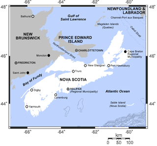
The Minas Basin is an inlet of the Bay of Fundy and a sub-basin of the Fundy Basin located in Nova Scotia, Canada. It is known for its extremely high tides.

Spencer's Island is a rural community in Cumberland County, Nova Scotia, located at the western end of Greville Bay on the Bay of Fundy. The community is named after a small island 45°19′50″N64°41′30″W of the same name located offshore from nearby Cape Spencer. According to local oral history, the island, cape and community trace their name to a man named Spencer who is buried on the island. However the name more likely comes from Lord Spencer, a British statesman at the time the community was settled.

Advocate Harbour is a rural community located in Cumberland County, Nova Scotia, Canada.

Parrsboro is a community located in Cumberland County, Nova Scotia, Canada.
The Fundy Shore Ecotour is a former scenic drive and network of tourist destinations in the Canadian province of Nova Scotia and encircles several sub-basins of the Bay of Fundy, which contains the highest tidal range on the planet.

The Fundy Geological Museum is a geological museum in Parrsboro, Nova Scotia, Canada. It first opened in 1993. It has received over 300,000 visitors since it opened, averaging more than 21,000 per year. The museum is part of the Nova Scotia Museum system.
Springhill Junction is a Canadian rural community in central Cumberland County, Nova Scotia approximately 4 kilometres (2.5 mi) northwest of Springhill, Nova Scotia.

Parrsboro Regional High School also known as PRHS is a school located in Parrsboro, Nova Scotia, Canada. PRHS consists of six grades- 7,8,9,10,11 and 12, with approximately 150 students and with 1 class per grade.

Parrsboro Harbour is a Canadian harbour located in Cumberland County, Nova Scotia.

Partridge Island is a significant historical, cultural and geological site located near the mouth of Parrsboro Harbour and the town of Parrsboro on the Minas Basin, in Cumberland County, Nova Scotia. It attracts many visitors including sightseers, swimmers, photographers, hikers and amateur geologists. Partridge Island is actually a peninsula that is connected to the mainland by a sandbar isthmus. According to local legend, the isthmus was created during the Saxby Gale of 1869. The hiking trail to the top of the island affords scenic views of key landforms on the Minas Basin including Cape Blomidon, Cape Split and Cape Sharp. The nearby Ottawa House By-the-Sea Museum contains artifacts and exhibits illustrating the history of the former village at Partridge Island, which dates from the 1770s. Partridge Island is a favourite hunting ground for rockhounds because its ancient sandstone and basalt cliffs are steadily eroded by the fast-moving currents of the world's highest tides. Rocks and debris worn away from its cliffs are dragged down the beach making it possible to find gemstones, exotic-looking zeolite minerals and fossils. Fossil hunters are warned, however, that although one or two loose specimens may be collected, Nova Scotia law requires that they be sent or taken to a museum for further study, and no fossils may be excavated from bedrock without a permit.

Athol is a very small community along Route 302 in the Canadian province of Nova Scotia. It is located between Amherst and Parrsboro. The community is named after John Murray, 4th Duke of Atholl.

The Kennetcook River is a river that flows through Hants County, Nova Scotia. From headwaters near the mouth of the Shubenacadie River, the Kennetcook traverses about 45 kilometres of mostly rural terrain, discharging into the Avon River at Windsor. The Kennetcook cuts through fossiliferous limestone rocks for part of its length. A tidal river near its mouth, the Kennetcook experiences a tidal bore which may be seen at Scotch Village. It is a known salmon river popular with anglers.
The Maccan River is a small tidal river contained completely within Cumberland County, Nova Scotia. The river terminates at the confluence of River Hebert at Amherst Point, and empties into the Cumberland Basin. The river's tidal bore may be viewed from the Tidal Wetlands Park in Maccan. According to estimates by the Province of Nova Scotia, there are 9,092 people resident within the Maccan/Kelly/Hebert watershed in 2011.

Petite Rivière is a river in Nova Scotia, Canada entirely within Lunenburg County. It is fed by numerous lakes, and a portion of the watershed is the drinking water supply for the town of Bridgewater.

Black Rock is a community in the Canadian province of Nova Scotia, located in Cumberland County. It is located approximately 10 kilometres west of Parrsboro.

Newport Landing is a community in the Canadian province of Nova Scotia, located in the Municipal District of West Hants. This community is also known as Avondale, and has civic signage listed for both names. The historical name was 'Newport Landing'.

The Age of Sail Heritage Centre is a museum and heritage centre at Port Greville, Nova Scotia, Canada. It focuses on the history of Parrsboro Shore communities along the Minas Channel of the Bay of Fundy with an emphasis on the area's shipbuilding and lumbering heritage.

There are various Black Lakes in Nova Scotia, Canada. They vary widely in size, depth and usability. Many counties, such as Cumberland, Halifax, Inverness, and Pictou Counties have more than one Black Lake so named, while other counties mentioned in this article have only one named Black Lake.

The Parrsboro Shore is an area of Cumberland County, Nova Scotia consisting of the shoreline communities west of the town of Parrsboro. The Parrsboro Shore is generally defined as stretching along the Bay of Fundy from the town of Parrsboro westward around Cape Chignecto as far as Apple River. It includes the communities of Diligent River, Fox River, Port Greville, Ward's Brook, Fraserville, Spencer's Island, Advocate, the ghost town of Eatonville. Linked by Nova Scotia's Route 209, the communities form part of the Fundy Shore Ecotour.

St. George's Anglican Church is an historic Carpenter Gothic style Anglican church building located at 216 Main Street in Parrsboro, Nova Scotia, Canada.


