Southern Nova Scotia

Last updated
South Shore
Southern Nova Scotia
Southern NS map.png
The Southern Nova Scotia region as defined by Statistics Canada
Country Flag of Canada (Pantone).svg  Canada
Province Flag of Nova Scotia.svg  Nova Scotia
Counties Lunenburg County
Queens County
Shelburne County
Yarmouth County
Digby County
Area
  Land12,417.79 km2 (4,794.54 sq mi)
Population
 (2016) [1]
  Total113,185
  Density9.1/km2 (24/sq mi)
  Change 2011-16
Decrease2.svg2.5%
Time zone UTC-4 (AST)
  Summer (DST) UTC-3 (ADT)
Area code(s) 902
Dwellings61,948

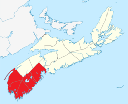
Southern Nova Scotia or the South Shore is a region of Nova Scotia, Canada. The area has no formal identity and is variously defined by geographic, county and other political boundaries. Statistics Canada, defines Southern Nova Scotia as an economic region, composed of Lunenburg County, Queens County, Shelburne County, Yarmouth County, and Digby County. According to Statistics Canada, the region had the highest decrease of population in Canada from 2009 to 2010, with a population decrease of 10.2 residents per thousand. [2] The region also has the second-highest median age in Canada at 47.1 years old. [3]

Contents

Politically defined

The South Shore is sometimes defined as part of the Halifax West, South Shore—St. Margaret's, and West Nova ridings at the federal level, or as the western rural part of the Halifax Regional Municipality, the Municipality of the District of Lunenburg, Queens County, and Shelburne County. There were five MLAs elected from this region in recent Nova Scotia provincial elections, when the region shifted from the Progressive Conservative Party to the more left-leaning New Democratic Party. It is generally considered to be a "swing" region that has changed political leanings in the recent past, and a key target for campaigning.

History

The South Shore was one of the first areas of North America to be colonized by Europeans following the French settlement at Port-Royal in 1605. The region, without good agricultural land, was only sparsely inhabited by the Acadians, although several settlements were established in present-day Shelburne County and the LaHave River valley. When the British took control of the region in 1713, they initiated a program of importing colonists from continental Europe, known as the Foreign Protestants, mostly from Germany and Switzerland. To this day the South Shore retains many German place names and surnames as well as a distinct accent compared to the New England settlers' influence in the Annapolis Valley or the Highland Scots' influence in northeastern Nova Scotia and Cape Breton Island.

On December 19, 1906, the Halifax and Southwestern Railway opened between Halifax and Yarmouth, finishing a project that had begun in 1885, and bringing more reliable land transport to the region. Although the South Shore did not play a major role during the First World War, the area saw significant military activity during the Second World War and the ensuing Cold War, as Shelburne and Mill Cove became home to Royal Canadian Navy bases, and a Pinetree Line radar station was established by the Royal Canadian Air Force at Baccaro. In 1966, Canada's first satellite communications (SATCOM) earth station began operations at Mill Village. In the 1970s and 1980s, the Highway 103 arterial highway was built.

During the 20th century, the South Shore became the centre of Nova Scotia's fishing industry, as fishermen in small boats operated from numerous tiny villages dotted along the coast. The larger communities also had fish plants and port facilities for larger off-shore trawlers, which began to see increased use following the Second World War. During the 1960s and 1970s, the impact of offshore processing and increasingly larger trawlers was being felt in communities, and the way of life on the South Shore was altered. As in many parts of Nova Scotia, many South Shore fishing communities all but disappeared as residents moved to larger urban centres in search of new opportunities. The decline in the fishery coincided with growth in the service industry, and specifically tourism.

The culture and economy along the South Shore gradually changed as the scenic area became a more common tourist destination. As more tourists came to appreciate the beauty and culture of the region, coastal land prices rose, small businesses catering to the industry sprouted up, and a vibrant art community took root.

Present day

Historical populations
YearPop.±%
1991126,812    
1996 124,538−1.8%
2001 121,935−2.1%
2006 119,175−2.3%
2011 116,080−2.6%
2016 113,185−2.5%
[4]

The South Shore is an important area for tourism in the province. It has a higher than average proportion of cottages, hotels, and tourist attractions, including Kejimkujik National Park. The provincial scenic travel way, the "Lighthouse Route" runs on Trunk 3 through most centres along the shore. The tourism industry is concentrated in the towns of Lunenburg, Chester, Mahone Bay, Liverpool, the five beaches surrounding Riverport, and the fishing community of Peggy's Cove. The largest community in the region is the town of Bridgewater, which is the commercial and industrial centre, although not a major tourism draw. Shelburne is second largest, with Liverpool and Lunenburg next. Lunenburg, a UNESCO World Heritage Site and the host to several major music festivals and arts events, plus the Bluenose II, is generally considered to be the cultural capital of the South Shore, with Bridgewater its industrial centre. However, that is over-generalized, as several key industries, notably shipping and aerospace and software, have a presence in Lunenburg that exceeds that in Bridgewater. Until 2009, the area was an important entry point for tourists travelling from New England, via a car ferry at Yarmouth. Two districts, Clare and Argyle, are notable for having proportionally large French-speaking populations. For the segment of tourism focused on Acadian history and culture, the major initiative is associated with the "Evangeline Trail" which extends through the Annapolis Valley and into the Southern Nova Scotia region as far as Yarmouth.

Climate

The region is one of the southernmost areas of Canada, second only to Southern Ontario. Due to this as well as its proximity to the Atlantic Ocean, the region enjoys a climate which is distinctly mild by Canadian standards. The microclimate phenomenon occurs frequently, as many settled areas are located a considerable distance from the ocean itself. Overall, the South Shore experiences a humid continental climate with high precipitation year-round. Summers are warm (occasionally hot inland) with high levels of humidity, although the heat is moderate compared with Central Canada. Winters are cold and damp, and although snowfall occurs frequently, it is often mixed with rain and snow accumulation is moderate, particularly along the immediate coast. Mild days occur comparatively often in winter, usually as a result of low-pressure systems. Spring and autumn are extremely unpredictable, and the most precipitation falls by far within the months of April and May. For example, in 2011, rainfall occurred in Lunenburg County for 43 consecutive days during this period.

Related Research Articles

The Maritimes Region of Atlantic Canada

The Maritimes, also called the Maritime provinces, is a region of Eastern Canada consisting of three provinces: New Brunswick, Nova Scotia, and Prince Edward Island (PEI). The Maritimes had a population of 1,813,606 in 2016, which makes up 5.6% of Canada's population. Together with Canada's easternmost province, Newfoundland and Labrador, the Maritime provinces make up the region of Atlantic Canada.

Lunenburg, Nova Scotia Coastal town and UNESCO World Heritage Site in Nova Scotia, Canada

Lunenburg is a port town on the South Shore of Nova Scotia, Canada. Founded in 1753, the town was one of the first British attempts to settle Protestants in Nova Scotia.

Lunenburg County, Nova Scotia County in Nova Scotia, Canada

Lunenburg County is an historical county and census division on the South Shore of the Canadian province of Nova Scotia. Major settlements include Bridgewater, Lunenburg, and Mahone Bay.

Yarmouth County County in Nova Scotia, Canada

Yarmouth County is a rural county in the Canadian province of Nova Scotia. It has both traditional Anglo-Scottish and Acadian French culture as well as significant inland wilderness areas, including over 365 lakes and several major rivers. It comprises three municipalities: the Town of Yarmouth, the Municipality of the District of Yarmouth, and the Municipality of the District of Argyle.

Bridgewater, Nova Scotia Town in Nova Scotia, Canada

Bridgewater is a town in Lunenburg County, Nova Scotia, Canada, at the navigable limit of the LaHave River. With a 2021 population of 8,790, Bridgewater is the largest town in the South Shore region.

Mahone Bay, Nova Scotia Town in Nova Scotia, Canada

Mahone Bay is a town on the northwest shore of Mahone Bay along the South Shore of Nova Scotia in Lunenburg County. A long-standing picturesque tourism destination, the town has recently enjoyed a growing reputation as a haven for entrepreneurs and business startups. The town has the fastest growing population of any municipality in Nova Scotia according to the 2016 census, experiencing 9.9% population growth.

Yarmouth, Nova Scotia Town in Nova Scotia, Canada

Yarmouth is a town in southwestern Nova Scotia, Canada. A port town, industries include fishing, and tourism. It is the terminus of a ferry service to Portland, Maine, run by Bay Ferries.

Middleton, Nova Scotia Town in Nova Scotia, Canada

Middleton is a town in Annapolis County, Nova Scotia, Canada. Situated on the north bank of the Annapolis River, it is located near the centre of the Annapolis Valley, from which it gets its nickname, "The Heart of the Valley".

Digby is an incorporated town in southwestern Nova Scotia, Canada. It is in the historical county of Digby and a separate municipality from the Municipality of the District of Digby. The town is situated on the western shore of the Annapolis Basin near the entrance to the Digby Gut, which connects the basin to the Bay of Fundy.

South Shore—St. Margarets Federal electoral district in Nova Scotia, Canada

South Shore—St. Margarets is a federal electoral district in Nova Scotia, Canada, that has been represented in the House of Commons of Canada since 1968. It covers the South Shore region of Nova Scotia.

Shelburne, Nova Scotia Town in Nova Scotia, Canada

Shelburne is a town located in southwestern Nova Scotia, Canada.

Riverport, Nova Scotia Community in Nova Scotia, Canada

Riverport is a village in Lunenburg County, Nova Scotia, Canada. The harbour of Ritcey Cove is free from shoals and safe from every wind, considered one of the finest in North America. Riverport is a five-minute drive to several public beaches including Hirtle's Beach, Kingsburg Beach, Oxner Beach, Rose Bay Beach and Spindler Beach.

Halifax and South Western Railway

The Halifax and South Western Railway was a historic Canadian railway operating in the province of Nova Scotia.

The Aspotogan Peninsula is a peninsula in the eastern part of Lunenburg County, Nova Scotia, separating St. Margarets Bay in the east from Mahone Bay in the west. The peninsula was originally settled by second generation French immigrants on the east side and by second generation German immigrants on the west side. Traditionally fishing was a major industry for communities throughout the peninsula, however other primary industries such as farming and forestry were historically important as well. Shipping and shipbuilding were secondary and tertiary industries that also came into prominence during the 19th and early 20th centuries.

Clarks Harbour Town in Nova Scotia, Canada

Clark's Harbour is a town on Cape Sable Island in southwestern Nova Scotia, Canada, located in the Municipality of the District of Barrington in Shelburne County. The main industry is lobster fishing. Owing to this as well as the town's history as a fishing community, the town is noted as the birthplace of the Cape Islander fishing boat.

Scouting and Guiding in Nova Scotia

Scouting in Nova Scotia has a long history, from the 1900s to the present day, serving thousands of youth in programs that suit the environment in which they live.

Geography of Nova Scotia

Nova Scotia is a province located in Eastern Canada fronting the Atlantic Ocean. One of the Maritime Provinces, Nova Scotia's geography is complex, despite its relatively small size in comparison to other Canadian provinces.

Nova Scotia Museum (NSM) is the corporate name for the 28 museums across Nova Scotia, Canada, and is part of the province's tourism infrastructure. The organization manages more than 200 historic buildings, living history sites, vessels, and specialized museums and about one million artifacts and specimens, either directly or through a system of co-operative agreements with societies and local boards. The NSM delivers programs, exhibits and products which provide both local residents and tourists in Nova Scotian communities an opportunity to experience and learn about Nova Scotia's social and natural history. More than 600,000 people visit the facilities each year.

Outline of Nova Scotia Overview of and topical guide to Nova Scotia

The following outline is provided as an overview of and topical guide to Nova Scotia:

Administrative divisions of Nova Scotia Local governance within Nova Scotia

The Canadian province of Nova Scotia is divided into 49 municipalities, of which there are three types: regional (4), town (25), and county or district municipality (20).

References

Coordinates: 44°13′30.4″N64°31′39.7″W / 44.225111°N 64.527694°W / 44.225111; -64.527694