
Cape Breton Island is an island on the Atlantic coast of North America and part of the province of Nova Scotia, Canada.

The Gulf of St. Lawrence is the outlet of the North American Great Lakes via the St. Lawrence River into the Atlantic Ocean. The gulf is a semi-enclosed sea, covering an area of about 226,000 square kilometres (87,000 sq mi) and containing about 34,500 cubic kilometres (8,300 cu mi) of water, which results in an average depth of 152 metres (499 ft).

Cape Breton Highlands National Park is a Canadian national park on northern Cape Breton Island in Nova Scotia. The park was the first national park in the Atlantic provinces of Canada and covers an area of 948 square kilometres (366 sq mi). It is one of 42 in Canada's system of national parks.

Cape Breton Regional Municipality is the Canadian province of Nova Scotia's second largest municipality and the economic heart of Cape Breton Island. As of 2016 the municipality has a population of 94,285. The municipality was created in 1995 through the amalgamation of eight municipalities located in Cape Breton County.
The Canadian Coast Guard College (CCGC) is a maritime training college and Canadian Coast Guard facility located in Westmount, Nova Scotia—a suburb of the former city of Sydney in the Cape Breton Regional Municipality.
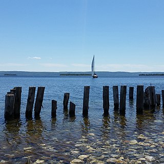
Bras d'Or Lake is an inland sea, or large body of partially fresh/salt water in the centre of Cape Breton Island in the province of Nova Scotia, Canada. Bras d'Or Lake is sometimes referred to as the Bras d'Or Lakes or the Bras d'Or Lakes system; however, its official geographic name is Bras d'Or Lake, as it is a singular entity. Canadian author and yachtsman Silver Donald Cameron describes Bras d'Or Lake as "A basin ringed by indigo hills laced with marble. Islands within a sea inside an island." The lake is connected to the North Atlantic by natural channels; the Great Bras d'Or Channel north of Boularderie Island and the Little Bras d'Or Channel to south of Boularderie Island connect the northeastern arm of the lake to the Cabot Strait. The Bras d'Or is also connected to the Atlantic Ocean by means of a lock canal completed in 1869—the St. Peters Canal, at the southern tip of the lake.

Highway 125 is a 28 km long controlled-access highway located in Nova Scotia's Cape Breton Regional Municipality. The provincial government named it Peacekeepers Way on August 18, 2008. Part of the provincial 100-series arterial highway network, Highway 125 encircles the west side of Sydney Harbour, from an interchange with Highway 105 at Sydney Mines to Trunk 4 immediately east of Sydney.
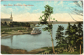
The Mira River is a Canadian river located in eastern Cape Breton Island, Nova Scotia.
Cape Breton South is a former provincial electoral district in Nova Scotia, Canada which existed from 1933-2013. It elected one member of the Nova Scotia House of Assembly. In its last configuration, the district included Sydney and its western suburbs until the North West Arm and south along the Sydney River until Blacketts Lake.
Route 305 is a collector road in the Canadian province of Nova Scotia.
Westmount is a suburban community in the Cape Breton Regional Municipality.

Nova Scotia is a province located in Eastern Canada fronting the Atlantic Ocean. One of the Maritime Provinces, Nova Scotia's geography is complex, despite its relatively small size in comparison to other Canadian provinces.

Coxheath is a community in the Canadian province of Nova Scotia, located north of the Sydney River in the Cape Breton Regional Municipality on Cape Breton Island. The community is home to Riverview Rural High School, a secondary school with approximately 900 students in Grades 10-12 and Coxheath Elementary.
South Harbour is a small community in Victoria County, Nova Scotia, Canada. The community is located in the Aspy Bay region of Cape Breton Island. It sits on the Cabot Trail, and borders the Cape Breton Highlands National Park to the south.
Blacketts Lake is a lake and community in Cape Breton Regional Municipality, Nova Scotia, Canada. The town is in the Sydney River watershed, of which the lake forms the headwaters. The lake is home to the northernmost known population of Yellow lampmussel.

Spanish Bay is a bay in the Canadian province of Nova Scotia. It is located on the Atlantic coast of Cape Breton Island at the mouth of Sydney Harbour, which forms part of Spanish Bay. The current name for the bay, "Spanish Bay" appears on maps of the area at least as far back as 1708.

Sydney River-Mira-Louisbourg is a provincial electoral district in Nova Scotia, Canada, that elects one member of the Nova Scotia House of Assembly. The riding is represented by Brian Comer of the Progressive Conservative Party.

Bras d'Or Lake Biosphere Reserve is a UNESCO Biosphere Reserve located at Bras d'Or Lake, Cape Breton Island, Nova Scotia, Canada. It consists of a salt-water estuary watershed inland sea with three passages to the Atlantic Ocean. The Holocene transgression flooded a complex river-lake system of diverse geology, creating the small, deep inland sea with 12 significant watersheds draining both highlands and lowlands.
The Middle River of Pictou is a Canadian river located in Pictou County, Nova Scotia.

The Pugwash River is a river in Nova Scotia, Canada. It flows north into the Northumberland Strait in the village of Pugwash
